Wednesday, April 28, 2021

April 28th, 2021 … Summer of Fun continues!


We departed Crooked River SP on GA 40 to I-95. When in Rome, do as the Romans do. We followed Gary & Sheryl, our wagon master team in training! Let me tell you … they did a great job! They are learning with our friends, Ray & Pat, who are learning to become tail-enders!

Since we are traveling on the interstate, there is not much to see … so I will share some Georgia trivia with you! Did you know that the Georgia Colony originally spanned all the way to the Mississippi River. So for all those Georgians who hate on Alabama for one reason or another, those Alabamians may have been Georgians at one point in time.

"Sleep tight! Don’t let the bed bugs bite!" You’ve probably said this before at some point or another. But the phrase actually originated in Georgia because of Georgian colonials who would use Spanish moss to bind their mattresses together, bringing tiny little creepy crawly bed bugs in.

There is only ONE county in Georgia named after a woman. Only one, guys?! Out of 159?! This… (sigh) … is pretty embarrassing. Nancy Hart, a Revolutionary war rebel received the honor of having Hart County named after her. While wonderful, we need some more female recognition!! A side note, we have been to Nancy Hart’s cabin in Elberton (Elbert County) Georgia!

Last one … Georgia was originally founded as a felon colony. In 1732, James Oglethorpe wanted to use the colony of Georgia as a place for prisoners who were unable to pay their debts.

From I-95 as we crossed the East River we could see the Sidney Lanier Bridge, located at the entrance to the harbor at Brunswick, Georgia. The bridge was named after Georgia poet Sidney Lanier, whose poem The Marshes of Glynn is set in Brunswick and describes the vast open saltwater marshes in Glynn County. It replaced an earlier lift bridge. Given that 20 large ships enter or exit the harbor each day, the lift bridge was often closed for many hours each day. In shrimping season, the bridge would be raised many more times. As a result, traffic across the old bridge was often backed up. Another key reason for building a new bridge is that many modern ocean going ships are larger than what the old lift bridge would allow. That prevented Brunswick from competing on a global scale. In fact, two ships struck the old lift bridge, causing 10 deaths and resulting in the bridge being closed for many months.

Our wagon masters did a great job telling us little known facts about Georgia, but they also pointed out interesting items to see along the way! The first interesting thing was spotted by Nancy … wild pigs on the side of the highway! Sheryl caught the second set of pigs a few miles up the road!


From its headwaters in Appalachia to its mouth at the Atlantic Ocean, the Savannah River forms the border between the states of Georgia and South Carolina, draining a watershed of 10,577 square miles. It originates in the mountains of North Carolina, South Carolina and Georgia near Ellicott Rock, the point where the three states meet. Tidal action influences water levels and flows about 45 miles upriver from the mouth. The Savannah broadens into a marine estuary before flowing into the Atlantic Ocean near Tybee Island.

I found this cute town logo on their water tower, the turtle interested me, as the town name is Ridgeland. That name does not conjure up the thoughts of a turtle! But, I learned it was originally known as Gopher Hill, the Town of Ridgeland was incorporated in 1894 and was the first railroad stop at the highest point between Savannah and Charleston, which is how the Town’s trademarked motto “The High Point of the Lowcountry” came about. Ridgeland is the historic “gateway” to the South Carolina lowcountry. Ridgeland is one of the last, remaining authentic lowcountry communities. Ridgeland is rich with pre-revolutionary and civil war history and is well-known for its commitment to preserving natural resources, small-town charm and business-friendly environment. They are home to several award-winning South Carolina BBQ Trail restaurants.

Coosawhatchie River … Coos a what? Named for the Coosa Indians that once inhabited the banks. The Coosawhatchie, a tidal river that originates near the Town of Allendale, and accepts drainage from Black Creek (Lake George Warren) and Cypress Creek before merging with the Pocotaligo River to form the Broad River. The Broad River joins the Chechessee River and the Beaufort River to form Port Royal Sound, emptying into the Atlantic Ocean.


We exited I-95 onto US 17 and I saw a sign for Port Royal Sound. It’s not a town, so what is it? Let’s first define a sound and describe some of the geological features that make up the Port Royal Sound Area. A sound is an ocean channel between two bodies of land, yet still accessible by ocean-going vessels. This means that the channels, which are relatively shallow and narrow bodies of water, are deep enough to allow deep-hulled ships to pass through unscathed. Almost all of the rivers and creeks in the Port Royal Sound watershed are not what you traditionally think of as rivers. Port Royal Sound rivers don’t have a headwater originating inland, either in the mountains or in the coastal plain, with fresh water flowing toward the ocean. Instead, ocean tides drive water flow in the Port Royal Sound Area rivers. These high tides drive ocean water through a network of tidal rivers and creeks that extend 20 miles inland. Tidal creeks are easily recognized at a distance because they are bordered by grasses and rushes that can tolerate regular salt-water flooding. Low tide reveals muddy banks pockmarked with thousands of holes made by fiddler crabs and bordered by intermittent oyster beds.

The Ashepoo, Combahee and Edisto Basin (abbreviated as ACE Basin) is one of the largest undeveloped estuaries along the Atlantic Coast of the United States. The Ashepoo, Combahee and South Edisto rivers combine into the larger St. Helena Sound and drain a significant portion of the Lowcountry region. The 1.6 million-acre ACE Basin watershed is one of the largest areas of undeveloped wetlands/uplands ecosystems remaining on the Atlantic Coast. This remarkable interlocking web of ecosystems includes forested uplands and wetlands, extensive tidal marshes, managed wetlands, barrier islands, and peatlands. It supports 33 types of natural plant communities and provides critical habitat for waterfowl, migratory birds and endangered species.

In historic Jacksonboro, SC you can find the Pon Pon Chapel of Ease. “Pon Pon” was Indian phrase for “settlement”. It was established 1725 by Act of the General Assembly, Pon Pon Chapel of Ease was one of two serving St. Bartholomew’s Parish after the Yemassee War in 1715 aborted plans for a parish church. At time of construction, the chapel site, was on the busy stage-coach thoroughfare which connected Charleston and Savannah.  President George Washington traveled this round on his Southern tour in spring 1791. In 1754, a brick chapel was erected to replace the earlier wooden structure.  This brick chapel burned in 1801, and Pon Pon Chapel has subsequently been known as the ‘Burnt Church’.  Rebuilt between 1819 and 1822, the chapel was in use until 1832 when it was reduced to ruins either by disrepair or a second burning. John Wesley preached two sermons at Pon Pon on April 24, 1737.  Also of significance is the church burial ground.  Here are the graves of two Congressmen, Aedanus Burke and O’Brien Smith, and numerous other local leaders.”


We arrived at Oak Plantation Campground in Charleston, our home for the next 5 nights. We got to work, by meeting the caravaneers that were here already and we put their numbers on their rigs and tow vehicles. We enjoyed an Italian dinner al fresco from a food truck! Provata - Authentic Italian & Fresh Pasta - Mobile Kitchen. We all had something different ... Stuffed Shells


Lagasana


Sausage with Peppers & Onions


Eggplant Parmesan


Stay tuned as our Adventures Continue!

April 27th, 2021 … Summer of Fun continues!

Today, we rose early and took the ferry to the Cumberland Island National Seashore. It’s a place where history and nature meet. St Mary’s is the gateway to Cumberland Island, Georgia's largest and southernmost barrier island. The pristine maritime forests, undeveloped beaches and wide marshes whisper the stories of both man and nature. Natives, missionaries, enslaved African Americans and wealthy industrialists all walked here.  Cumberland Island is 18-miles long and is also home to over 9,800 acres of congressionally designated wilderness.


After leaving the ferry, we started walking through the Maritime Forest toward the ruins. The Live Oaks form a dense canopy that shelters palmettos and delicate ferns cradled in branches. 


Spanish moss sways in the breeze. Painted bunting, summer tanagers, cardinals and pileated woodpeckers add color to the forest’s palette.


For our first stop on the island, we also explored the ruins of the Dungeness Estate. It’s really a glaring 19th Century example of the privileged 1%, Thomas Carnegie (Andrew’s brother) and his wife Lucy bought 90 percent of Cumberland Island off the southernmost coast of Georgia. This included building a gigantic 59-room St. Ann style mansion on the south shores. 


After being left abandoned and eventually burned, only ruins still remain. Initially planned as a winter getaway, after a series of illnesses, Thomas revised this to be his home in retirement. Construction began on the mansion in 1884, though, sadly, Thomas passed away before the estate was finished. When it was finally finished a few years later, Lucy and their nine children moved into the mansion. The estate also included an indoor pool, squash courts, a golf course, and other residences for the family’s 200 servants.


The estate flourished until the 1930s, and three other great estates (including Plum Orchard) were built elsewhere on the island for some of the children. With the advent of the Great Depression, the homes were slowly abandoned, as the island had no resources and everything had to be shipped in. Dungeness sat decaying until 1959, when a fire gutted the mansion, leaving only a skeletal group of ruins. Today, the ruins of the main house, the pool house, the gardens, and various other buildings still stand as a ghostly reminder of the wealth the island once contained. Although most of the island is now preserved under wildlife conservation efforts, we toured the exterior of the ruins and gained insightful knowledge of what the Dungeness mansion once looked like.


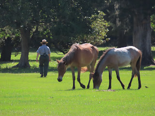
My main reason for wanting to travel to the island was to see the wild horses on the beach! But, first some history … A few horses were probably brought to Cumberland as livestock when Spanish missions were established in the late 1500s although evidence is sketchy. The earliest historic account of horses on Cumberland Island was in 1742. During the battle between the Spanish and the English over Fort St. Andrews on the north end of Cumberland, the Spanish found “fifty to sixty horses in a corral within the fort.” By the end of the 1700s, island landowners were reporting an estimate of 200 domestic horses and some mules kept as free ranging livestock on Cumberland.


During the early 1800s, several plantations were in operation on the island and horses played an integral role in transportation, work and recreation. In the turmoil during and after the Civil War, most of the horses were sold or otherwise removed from the island. When the Carnegie family moved to Cumberland in the 1880s, they brought horses for pulling carriages, riding, hunting and other recreational activities. Over 50 horses were stabled at Dungeness alone. 


Throughout the 1900s, new stock was introduced and some horses were taken off the island for sale. Property owners on Cumberland managed horses as free ranging livestock from the 1940s until the 1960s. By the time the park was established in 1972, horses had become feral on the island. We never did see them on the beach!


We asked a ranger for more information on the inhabitants of the island. We learned that there are still private residences on the island, with people living on the island include these residents, park rangers, volunteers and researchers. We learned that the horses, once domesticated, have reverted to a wild state and adjusted to surviving in a natural environment without help or support of any kind from humans. During their history on the island horses have been managed as both free-ranging and corralled livestock. 


But by the mid-1900s horses were roaming the island with no care provided from island residents. Cumberland has the only herd of feral horses on the Atlantic coast that is not managed (no food, water, veterinary care, or population control). The herd is affected by all the natural stressors faced by native wildlife. The Cumberland’s horses are closely related to Tennessee Walkers, American Quarter Horses, Arabians, and Paso Fino. She told us they estimate between 150 and 200 feral horses in residence on the island. The lifespan of horses on the island may be as long as 9 to 10 years. Causes of mortality include high parasite loads, drought-related stress, age, natural accidents, and suspected eastern equine encephalitis and West Nile virus.


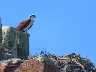
Some of us wanted to see the beach, so we walked and walked and walked. Before we found the beach, we found the Sand dunes, sometimes as high as 40-feet. They protect the island’s interior. These dunes, held in place by sea oats, are vital to the island’s ecosystem. We watched sand pipers scampering along the water’s edge and the sea gulls soaring on the ocean breezes. An Osprey may dive into a wave to emerge seconds later with a mullet.

As we walked back toward the ferry, we took the saltwater marsh boardwalk. At low tide the marshes resemble broad, tall grass plains. Fiddler crabs scurry across the mud flats and eat decaying vegetation. Raccoons hunt for crabs and shellfish. At high tide, it is all washed away and the grasses sway with the current and disappear into it.


Over 300 species of birds use the island and endangered sea turtles nest every year. Alligator, deer, turkey, armadillo and raccoon are commonly seen on the island. 


Besides the feral horses, we saw a turkey, 


an armadillo, 


a bright green gecko 


an Osprey with a nest 


and a snake with a gecko in it's grasp!


Stay tuned as our Adventure Continues!

Tuesday, April 27, 2021

April 26th, 2021 … Summer of Fun begins!

We enjoyed our last Monday morning coffee in the clubhouse with our friends before heading out on our Summer of Fun Adventure!

Zephyrhills is our home, it’s known for pure water, rolling topography, gentle breezes, and our senior population. It is also home to the headquarters of the Zephyrhills bottled water company. Zephyrhills began as the town of Abbott on April 18, 1888 and consisted of 281 acres. The town was named for Dr. Abbott who ran a drug store and practiced medicine in the area. The primary industries at the time were turpentine production and lumber. The Seaboard Coastline railroad established a depot in Abbott. In 1909, Captain Howard B. Jeffries, a Civil War Union veteran from Pennsylvania purchased 35,000 acres and created the Zephyrhills Colony Company with a plan to create a community for Civil War veterans, and the land sales industry became a part of the Zephyrhills story. It is said that Jeffries wanted to name the town after the soft, gentle breezes or “zephyrs” that blew across the rolling countryside. In 1910 the town of Abbott voted to change its name to “Zephyrhills” and was incorporated in 1914.

We took CR 54 to US 301, we will be on US 301 for most of our travel day! 

Dade City is the town next to Zephyrhills, it was named after Major Francis L. Dade, who was a Major in Company B, 4th Infantry of the United States Army during the Second Seminole War. Major Dade was killed in a battle with Seminole Indians that came to be known as the "Dade Massacre".  He is buried at the Saint Augustine National Cemetery in Saint Augustine, Florida in St. John's County. Dade City was originally established on December 23, 1836 as "Fort Dade", a year after the "Dade Massacre" and the death of Major Dade.  In 1845 the Fort Dade post office was established in the home of James Gibbons, who served as its postmaster until his death less than a year later.  This post office was later abandoned and a new one was erected in 1884, located on what is now Church Avenue.  The community of Dade City was incorporated into Pasco County in 1889. In 1944 Dade City was the home of a prisoner of war (POW) camp, constructed by the US Military, which housed over 200 German prisoners of war.  The camp was just one branch (No. 7) of the 22 prisoner of war camps that were in Florida at the time.  The headquarters was located at Camp Blanding in Starke, Florida. The use of the Dade City camp was short-lived, with the closing and demolition of the camp two years later, when the camp was no longer needed.  


The city of Bushnell was our next big town, we passed through Ridge Manor first, but there is not much there. Bushnell was established in 1884, named after railway surveyor John W. Bushnell. By 1886 there were more than 100 orange growers in the county. The freeze of 1894-95 practically destroyed the citrus industry. Many of the farmers converted to cattle ranching. The success of that new industry brought more people to the county, and its population nearly doubled within ten years. The cattle industry became the most important industry rivaled only by the vegetable industry. The county courthouse in Sumterville was destroyed by fire in 1909. The loss of the courthouse along with nearly two decades of county records set off a round of political infighting that eventually led to a 1912 county-wide vote to establish a new county seat. Votes were cast between the towns of Wildwood and Bushnell. By a margin of only nine, Bushnell was selected the new county seat for Sumter County – Bushnell 657, Wildwood 648 votes.

Coney Island Footlong Hot Dogs is coming to Wildwood Florida! In 1960, Darrell and Gertrude Todd and Family from Brooksville opened Coney Island Drive Inn in an old boat manufacturing building. Elvis Presley was in Inverness, Florida in 1961 filming a movie and legend has it he ventured down to Brooksville for one of the Famous Footlongs. In 1971, Coney Island Drive Inn was purchased by Ralph and Gene Collins. In 1972, the movie Death Dream was filmed in Coney Island for a day and was the highlight of the movie. In the Mid 1970's, Walt Disney World was the only other institution that used more footlong Hotdog buns in the state than Coney Island Drive Inn. Their iconic mascot, Diggity Dog was born into the Family in the mid-seventies and has been the Brooksville Icon since. Previous owners include, Tom Collins, son of Ralph and Gene Collins, purchased the family business with his daughter Daiquiri. The Hensley Family purchased the Drive – Inn and an old tradition was kept in place. Sally Lee purchased Coney Island Drive-Inn with her son Carter Lee. They purchased old turpentine building in Zephyrhills for their second location. Then they opened a location in Crystal River and Wildwood makes their fourth location.

Who does not love to get fresh citrus from Florida in the dead of winter in a northern state? In Oxford, Florida you will find Jennings Citrus Packing. They are currently closed for the 2020-2021 season, but will start taking orders in the fall again! Houston and Grace Jennings, moved with their five children from Alabama to Florida in 1949. They started sending citrus by train to family and friends for the holidays. As word spread, their business started and grew, and they continue the tradition today. 

In Callahan Florida we took FL 200 east toward US 17. The Florida Georgia State line is actually the St. Mary's River. It is a rambling stream of black-water that separates Florida & Georgia on the east coast. It starts in the Okefenokee Swamp and winds along a 130 mile path leading to the Atlantic Ocean & the Cumberland Sound. Total distance "as the crow flies" is about 40 miles.

The first town in Georgia is St Mary’s. St. Mary’s, Georgia originally began as a town, established by the British in 1787. After St. Augustine, Florida, St. Mary’s, Georgia is the second-oldest continually inhabited city in the US. Local inhabitants of Camden County gathered on Cumberland Island and signed a charter for "a town on the St. Mary’s" on November 20, 1787. There were twenty charter members who each received four town lots and one marsh lot; each lot was 4 acres square. These twenty city founders are named on an historical marker in downtown St. Mary’s: Isaac Wheeler, William Norris, Nathaniel Ashley, William Ashley, Lodowick Ashley, James Seagrove, James Finley, John Fleming, Robert Seagrove, Henry Osborne, Thomas Norris, Jacob Weed, John Alexander, Langley Bryant, Jonathan Bartlett, Stephen Conyers, William Keady, Prentis Gallup, Simeon Dillingham and Richard Cole. 


Today the city is home to The National Seashore's visitor center and boat access; the annual St. Mary’s Rock Shrimp Festival; the St. Mary’s Submarine Museum, and Crooked River State Park. It is bordered by Kings Bay Naval Submarine Base, home port for several Ohio-class submarines. 


We arrived at Crooked Island State Park, to meet up with our friends. The park is on the southern tip of Georgia’s Colonial Coast, this park is the perfect spot for enjoying the Intracoastal Waterway and maritime forest. Our campsites are surrounded by palmettos and Spanish moss-draped oaks, near the tidal river. 


Nancy and I walked to the boat ramp and the barnacles are plentiful! There is a nature trail that winds through forest and salt marsh. You can see gopher tortoises, fiddler crabs, herons and other birds. 

I was able to capture the first of only two supermoons of 2021. The Super Pink Full Moon. Supermoons are full moons that appear bigger in the sky than usual, though the difference may not be noticeable to the casual observer. During a supermoon, the full moon can appear up to 14% larger and 30% brighter than when it is at its farthest from Earth. That’s because it coincides with the moon's location at the closest point to Earth in its orbit.

Stay tuned for more, as our Adventures Continue!