Saturday, May 7, 2016

Florida to New York - 2016 - Day Four - SC to VA

This morning we departed Fort Chiswell RV Park. It is the perfect overnight stop. We have stayed before and will again! We got right onto Route 52 and right away got on US 11, which was on I-81. We traveled on I-81 for a while, until US 11 veered back onto its own course. It started out as a slightly overcast day, but the sun kept peeking through the clouds!

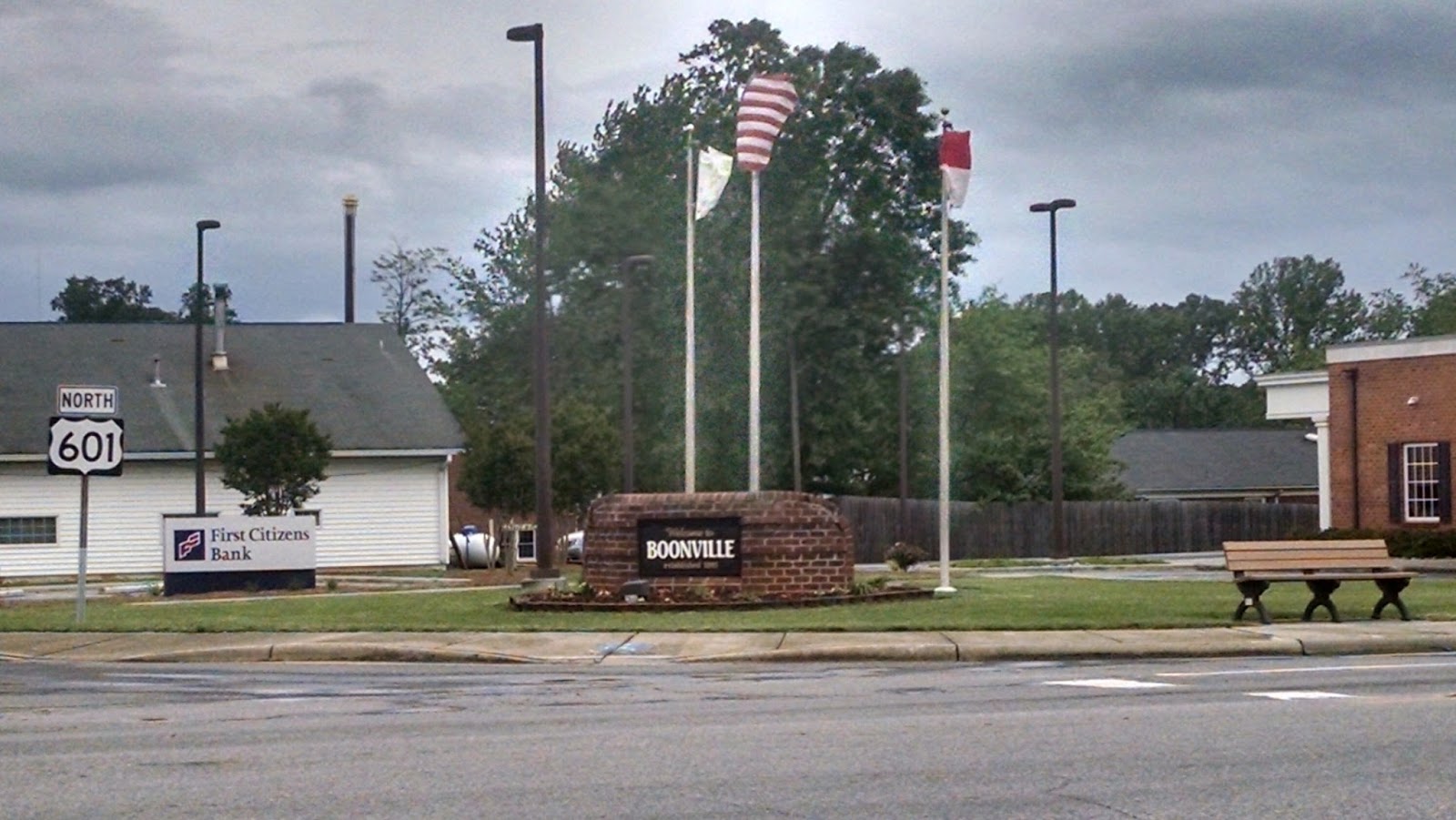
We passed through Troutville, Virginia. The name evokes the thought of huge trout swimming in the streams and rivers. But really, was the town named as a beacon to signal the fishermen to come! No, sorry to burst that bubble. The town of Troutville was established in 1956. In 1881, this area had no name. The railroad passed through and a station was built, there were three houses then which were occupied by brothers John, Jim, and George Trout, thus the area was called Troutsville. It became an important shipping center in the 1890s. In 1895, Troutsville was a thriving town with an active shipping point, farming, canneries, packing houses and factories. The name of the town was later changed to Troutville.

I often wonder how the Blue Ridge Mountains, got their name. Well, when you look at them, they really do look blue! I could look at these mountains all day and never get tired of the beauty of this mountain range! This time of year is especially beautiful, because the trees are just starting to bloom!

Established by Col. John Buchanan in 1811, the Town of Buchanan retains a blend of historic structures spanning almost two centuries. Standing as a testimony to successive generations, downtown’s historic buildings tell a story of each building, its occupants and their contributions to our community’s history and culture. You can explore elements of Buchanan’s Antebellum Canal Era, the site of Hunter’s Civil War Raid, witness the height of the Victorian era’s excitement as well as the arrival of the railroad and the twentieth century’s shift from horse and buggy to the model T Ford and beyond. My favorite thing to visit the Buchanan Swinging Bridge. It is the only one of its type to cross the James River. Portions of the bridge date back to 1851 as the Buchanan Turnpike Company Toll Bridge. On June 13, 1864, Confederate General McCausland burned the covered bridge to prevent Federal Troops under General Hunter’s command from crossing the James River. Following a series of replacement bridges, the Buchanan Swinging Bridge was constructed on the earlier piers in 1939. Due to its unique position between the Allegheny and Blue Ridge Mountains, Buchanan, Virginia is known as “Gateway to the Shenandoah Valley,” to those traveling north.

Natural Bridge – I great stop, it offers some amazing views. You had better like to walk, if you want to see the falls. But, there are some times of the year that the falls is only a trickle and you won’t know until you walk all the way to it! Oh well, it is still a nice walk after sitting in the RV. It is a must do, it you are in the area. There is ample parking for RVs closer to the road. It is not striped , so hopefully you are parking with other considerate RVers.

Enchanted Castle Studios offers a unique view from the road, a Viking on top of a windmill. The sad thing is it is not an attraction to visit or tour. They manufacture large fiberglass figures for the amusement industry. Once there was a studio tour here, but a fire forced it to close in 2001. The studio mastermind is Mark Cline. You can see some of his work in other areas around Virginia.
He also created the Elephant in front of the Natural Bridge Zoo on Route 11. He also is working on the Dinosaurs across the road from the Zoo and he created Foamhedge.
Foamhenge," a life-sized plastic foam replica of England's famous Stonehenge monument. Sadly, it has stood for 12 years and now it needs a new home. Originally installed an April Fool's Day stunt. News outlets report that artist Mark Cline must move the monument before Aug. 1 because Foamhenge sits on property that will become part of the new Natural Bridge State Park. The replica of the configuration of huge, upright stones in Wiltshire, England, has served as a local tourist landmark since it was unveiled. Cline says he built the free attraction to entice travelers off the road and has been impressed with its enduring popularity. He wants to give the replica to someone who is prepared to welcome a constant flow of curious visitors.

Virginia Gold, takes your mind to the nuggets of gold, big dollars, etc … but we are not the gold we blogged about yesterday. Virginia Gold is an Orchard, a family-run farm dedicated to growing the very best tasting Asian pears.  Asian pears are unique, but what makes Virginia Gold Orchard special is the fact that its pears are considered by many to be the best they have ever tasted. Many other pears - often shipped in from outside the United States - are picked green, days or weeks before they are truly ripe! They always pick there pears at the peak of ripeness, allowing the warm Virginia sun to give the pears their full, unique flavor. They then lovingly pack each box themselves at the orchard, by hand, to ensure only the very best pears reach you. Yum, can’t wait to get some when they are in season!

The monument to the 54th Pennsylvania Infantry Regiment is just north of New Market, Virginia. It was erected on October 25, 1905. A brass tablet beneath the monument explains the monument's rededication in 1984. The monument is next to the Bloody Cedars wayside marker, which tells the story of the 54th Pennsylvania at New Market, where they suffered the second-highest regimental loss in the battle. In 1984, title to this monument was given to the New Market Battlefield Park. The monument was originally dedicated on 25 October 1905 to the men of the 54th Pennsylvania Infantry, it now serves as a memorial to all who fought at the Battle of New Market on 15 May 1864.

McNeill’s Last Charge occurred just south of Mount Jackson, Virginia. History indicates that in the predawn darkness of 3 Oct. 1864, Capt. John Hanson McNeill led thirty of his Partisan Rangers against a hundred-man detachment of the 8th Ohio Cavalry Regiment that was guarding the Meems Bottom Bridge. The attack ended in fifteen minutes with most of the guard captured and McNeill, among the best-known Confederate partisan commanders, mortally wounded.

Last Indian Settler Conflict is the title on the wayside marker. It is on US 11, between Edinburg and Woodstock.
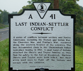
This history of the marker itself is interesting, but first this is what it says: ‘LAST INDIAN-SETTLER CONFLICT: A series of conflicts between settlers and Native Americans, including the French and Indian War, the Cherokee War, and Pontiac’s War, occurred along the western frontier of the colonies. The last documented clash in the Shenandoah Valley took place nearby in 1766. A small band of Indians attacked the Sheetz and Taylor families as they fled for safety to the fort of Woodstock. Mathias Sheetz and Taylor were both killed, but their wives used axes to fight off the Indians and escape with the children.’ I learned more about this marker in an e-book called ‘Lies Across America: What American Historic Sites Get Wrong’. In this case, there is a new sign that corrects an earlier version of the marker, which was hit by a snow plow in 1994 and had to be replaced. Here's what the old marker said: ‘LAST INDIAN OUTRAGE: Here, in 1766, took place the last Indian outrage in Shenandoah County. Five Indians attacked two settler families fleeing to Woodstock. Two men were killed; the women and children escaped.’ They used "Conflict" instead of "Outrage" in the title, all is politically correct now … why can’t we let historical markers be and take them at face value for the era they are representing?!
If you go through Woodstock Virginia, you must stop at a small garden in downtown. At first glance it looks like there is a stone hiker standing there. The garden is called “Jane's Garden” in honor of Jane Beasley, a former Enhancement Coordinator, for all of her hard work and dedication in the beautification and improvement of the Town. To increase its beauty, the Town of Woodstock has placed our first piece of public art in Jane's Garden. The theme of the piece at this location is meant to "Capture the Valley" and PAC-Man was chosen because he, or is it a she, represents people who long ago settled in our beautiful Shenandoah Valley. In the words of PAC-Man's talented sculptor, Craig Gray, "He is symbolic of the travelers who walked across our country to 'capture' better places to live, work, and raise families. He could be about life and our experiences... the sharp edges rounded as we make our journey."  Better hurry, if you want to catch a glimpse … PAC-Man will only stand still for so long … in August of 2017, he will walk on!

On Route 11, it is a quick trip through West Virginia and across the Potomac into Maryland. It is interesting how Route 11 transforms itself the entire length! It is a winding two lane road, with no shoulders. At other times, it is a four lane divided highway with majestic trees in the median. Lastly, it is joined with Interstate 81 and takes on the “fast pace” that many of us live today. Personally, we prefer the slower pace of the two lane Route 11. I love to pass through the small towns that take you back to the slower pace and family atmosphere that surround these towns.

Spending the night in Williamsport MD at Hagerstown Antietam KOA, we have been here before and love this place! Sits along a creek and offers loads of character!

Thursday, May 5, 2016

Florida to New York 2016 - Day Three - SC to VA


Everyone was up early this morning ready to hit the road! We departed the Cambridge Camden RV Park this morning and headed back north on Route 601, into the town of Lugoff, NC. The RV park is nothing fancy, but offered a great respite off the road. We were entertained by a mother cat trying to get her two kittens to follow her as she tried to relocate them from under a motorhome. She worked very hard at it and finally after several hours of back and forth and coaxing ... she got both kittens to follow her.

Right on Route 601 is the RC Pit Cross Track, an off-road supercross track. It reminded me of the RC track the residents and guest built at Majestic Oaks RV Resort. There are many lanes and many more humps and jumps and a few straightaways. There is a large raised driver’s stand and several spectator bleachers. The surface is hard packed clay. There were only a few racers this morning!

Camden South Carolina is home of the Battle of Camden, that was fought August 16, 1780, during the American Revolution.  The Battle of Camden was a lopsided victory for the British. Despite the spread of dysentery among his men, Continental General Horatio Gates chose to engage British General Charles Cornwallis’s forces. The illness depleted the Patriot advantage in troop numbers, and the British pressed forward aggressively as the only side in possession of bayonets. With the encounter resulting in nearly 2,000 Patriots killed or taken prisoner and heavy losses of artillery, Gates was removed from command and replaced by Nathanael Greene.

On Route 601 there is a huge mining operation, we saw countless trucks entering and exiting. Located in Lancaster County, the historic Haile Gold Mine was one of the first operating gold mines in the US. Established long before the gold rush of California, the mine was discovered in 1827 by Benjamin Haile and has been operated on and off for nearly 200 years. Today, it is owned by OceanaGold an exploration and development company focused on becoming a producer of precious metals in the United Sates. The mine is confirmed to contain 2 million ounces of gold reserves. Utilizing the most advanced technology and mining techniques, they are investing over $300 million to build the mine.  On average they spend about $3 million per month locally through labor and the purchase of local goods and services. That astounding figure doesn’t even account for the individual spending of our employees and contractors who will also make a range of purchases, from new homes and new cars to meals and gasoline. Wow, this mine has been a big boost to the economy and unemployment!

Have you ever seen a 40 Acre Rock? On Route 601, between Kershaw and Pageland is the Flat Creek Preserve. The most prominent feature is the massive rock that you can walk across and admire the scenery. It is named for a massive granite standing rock that is actually closer to fourteen acres in visible size. The rock is a celebrated example of granite outcropping in the Piedmont, is one of several exposures throughout the region. Many of the others, though, are mined for their valuable high-quality granite, the state's official rock. Unfortunately, vandals have defaced much of the main rock with spray-paint. However, it is still an amazing sight!

Crossing from SC into NC does not offer much fanfare. No welcome center, just a small sign after a gas station and a small sign.

In Midland North Carolina you can find the Reed Gold Mine Historic Site. The Reed Gold Mine is the site of the first documented gold find in the US. From this discovery, gold mining spread gradually to nearby counties and eventually into other southern states. During its peak years gold mining was second only to farming in the number of North Carolinians it employed. The estimated value of gold recovered reached over one million dollars a year. North Carolina led the nation in gold production until 1848, when it was eclipsed by the great rush to California. Who knew? Everyone always thought that California was the only great gold rush!

Our route today, took us through Historic Salisbury, why makes Salisbury so historic? Their chamber of commerce wants you to experience authentic North Carolina heritage in many unique ways while savoring the charm and character of an area rich with centuries of history, adventure and discovery.  From the early days of Daniel Boone, the African American Heritage Trail, to the civil war history and Historic Downtown Salisbury, there is something to interest everyone.

We went through Boonville NC and thought of our friends Claude & Shirley Riegler. Here is a picture of the “southern” Boonville … just for you northern Boonville folks!

I wish I could have snapped a picture of this … believe it or not … near the town of Dobson North Carolina, there was a home with beautifully manicured flower beds and in one of the beds was a life size wood carving of a character from the ‘Plant of the Apes.’ I kid you not … I stared at it too long to figure out what it was to capture a picture!

In Mt Airy NC, Route 601 ends and we navigated onto Route 52. Mt Airy is Hometown of Andy Griffith and host to the annual Mayberry Days celebration and every Andy Griffith, including many resturants. There is Aunt Bea Barbeque & Catering; Goober’s 52; Barney’s CafĂ© and Mayberry Meats & More.

Starting into Virginia, we knew we were getting closer to the Blue Ridge Mountains, because we started to climb in elevations. It is a winding narrow road for most of the way, but offers some beautiful sights, if it was not raining! Baby Geek-E-Bird was not a fan of the winding roads. Our Winnebago Aspect with a Ford V-10 engine, towing our Jeep, had no issues on the climb and the decent.

Do you wonder where the slogan ‘Virginia for Lovers’ came from? I always have! The phrase came from a creative team headed by George Woltz of Martin & Woltz Inc. According to Martin, a $100-a-week copywriter named Robin McLaughlin came up with an advertising concept that read, "Virginia is for history lovers." For a beach-oriented ad, the headline would have read, "Virginia is for beach lovers"; for a mountains ad, "Virginia is for mountain lovers," and so on. Martin thought the approach might be too limiting. Woltz agreed, and the agency dropped the modifier and made it simply "Virginia is for Lovers." The first ad mentioning the new slogan ran in the March 1969 issue of "Modern Bride." The phrase was considered bold and provocative, but it was also just plain smart from a marketing perspective.  Virginia is for Lovers of . . . No one knows exactly why "Virginia is for Lovers" has been so durable, but part of the mystique of the slogan is that it has meant many things to different people. Today, a new generation is discovering love for Virginia’s mountains, beaches, history, theme parks, vibrant cities, outdoor activities, sports and hospitality. And the love story continues.

Field of Flowers at Pleasant Hill Farm offers a cut your own flowers; fill a Mason jar for only $7. The farm is located in eastern Wythe County, in beautiful Southwest Virginia. The land in this part of Virginia features mountains, hills and rolling farm land. It offers spectacular views of the Blue Ridge Mountains. In the spring, they have Daffodils and Tulips, during the remainder of the year, they offer many varieties of annuals and perennials for you to choose from. There are over 50 large flower beds of blooming annuals and perennials spread over 5 acres. They also host weddings and other events year round!

We ended our day at Fort Chiswell RV Park in Max Meadows VA. Many of our friends have stayed here as they made their ways north … Patty & Ron Stevens; Jack & Jackie Laubach and Bob & Judy Carron before us! I am sure there will be more friends behind us! Happy Cinco De Mayo to everyone! I enjoyed a little "Rita" in honor of the special day!


Wednesday, May 4, 2016

Florida to New York 2016 - Day Two - Georgia to South Carolina

Departed Mossy Oaks and headed North on US 301 again today. Mossy Oaks got its name from the massive live oak trees at the entrance of the park. These are hundreds of years old, the mighyt oaks have large amounts of moss hanging from their huge limbs. This park offered us the quietness and tranquility of a restful forest of pines, cedars, oaks and other hardwoods.

Along US 301, where the sign for the park is located there is another sign for a local BBQ joint. Hillbilly’s Grill & BBQ some locals call it Hungry Hillbilly Grill & BBQ. The reviews are good and the prices are average. Next time, we will have to check it out! Both of these are just south of Jesup. Jesup, Georgia is home to the oldest Drive-In Movie Theater in Georgia. It is very well maintained and is playing current movies! Their motto is “See the Stars under the Stars.” The current owners have owned it since 2012. Renovations they completed were all to improve the experience of the Drive-In by enhancing the nostalgic ambiance. They added dĂ©cor from the 1950s era, including carhops (dressed in 50’s attire) who can take food orders from your car. The Jesup Drive-In is a real treasure! In 1958, there were more than 4,000 drive-ins in operation across the US, today only 338 remain.

GOD was watching over us today, and that was evident in the rays of sunshine that peaked out through the early morning clouds. It was a perfect morning to travel. It was light, but the sun was not beating down on us. Some of the roads we drove on today had seen rain last night, but we were dry where we stayed. Some of the rains must have been heavy, because we had standing water on some side roads.

In downtown Glennville, there is a mural on the wall that depicts all that makes Glennville great, including the cotton crop, the train that moves the goods and the famous Vidalia Onion. Tattnall County, which includes Glennville, is the largest and grows more Vidalia Sweet Onions than any of the other Vidalia Sweet Onion growing counties, contributing approximately half of the entire state crop each year.

US 301 takes us through Glennville Georgia. Glennville’s biggest annual event, the Glennville Sweet Onion Festival, is in its 40th year in 2016. We are just a few days ahead of the big event … I am sad, but Charlie is glad! It is held on the second Saturday of each May and celebrates the harvesting of the famous Vidalia sweet onion crop. The day begins with a “sweet” onion run and walk and a downtown parade, then on to the State Farmers’ Market on Highway 301 South for an array of arts and crafts, delightful entertainment, children's rides and games, delectable food (that includes fried sweet onion rings and blooming onions) of course!

We passed by many freshly plowed fields. Baby wanted to know why the dirt was red? There are over eighteen Georgia Grown Trail 301 locations in and around Glenville and Tattnall County. I found the Armstrong’s Cricket Farm, fresh produce at Georgia Grown U-picks DC Durrence Farms and Ray Farms. Just off 301 is the Watermelon Creek Vineyard. Hmmmm, sounds good to me! Isn’t there a country song about the Watermelon Crawl … could that be from Watermelon Wine? I would love to drive the whole trail and stop at each place, but it would have to be without the camper … let the Adventure Begin!

I wish I could have gotten a picture of this one! It had “Vinny’s Bargain Barn” stenciled on the roof. It is located on US 301 just outside Statesboro, Georgia. All I can say, is “one man’s junk, is another man’s treasure” … Vinny either had a bunch of junk or a million treasures! The piece that caught my attention was a Shoney’s Big Boy a top one of the roofs of the building, plus all the other large pieces of “treasure” around the building. I would be afraid to enter … but the American Pickers might venture inside!

As you cross the Savannah River, you can see the old swing bridge that used to be used to cross the river. This closed off section of the old highway has been converted by the state of South Carolina into a nice pedestrian walkway. At one time it was nicely shaded by the trees, now it is more overgrown and those branches have overtaken the bypassed highway and elevated bridge. The almost 3 mile pathway would allow you to walk right out onto the old bridge and look down into the Savannah River.

Before crossing the GA / SC State line, you see the Georgia Welcome Center. Surviving many rounds of budget cuts, Sylvania's welcome center, believed to be the nation's oldest continually operating roadside visitor center, soldiers on. It celebrated its 50th birthday in January of 2012. It was placed on the National Register of Historic Places at the end of 2011. This old 1962 relic perfectly captures the space age architecture that was so prevalent in the late 1950s and early 1960s.

Along the embankment of Interstate 26, where US 601 crosses over the Interstate you can see a patriotic rock formation of “USA” and an American Flag. This tribute to the US was created by SC Department of Transportation workers after 9/11. It looks as vibrant and alive today as it did the year they created it. Being a retired military officer, it warms my heart every time I see something a patriotic as this!

 
We followed along the back side of Fort Jackson and ended the day at Columbia Camden RV Park, just outside Ft Jackson SC. When we pulled into this park, we remembered that we had been here once before. It was when we had our truck camper and we were driving after dark. We found this place and paid at the “honesty box” check in and went to a site. Getting here in the daylight revealed that it is a quaint, well maintained family owned park. They have 83 sites with a few pull through sites, perfect for our overnight stop.
Each site even has 2 Adirondack chairs, which we enjoyed this afternoon in the nice breeze and sunshine. Maudine and Maynard enjoyed them too! Good Night!

Tuesday, May 3, 2016

Florida to New York to see Family and Friends


We started out our two lane adventure by heading north on Route 301. We are planning on taking 301 and 601 for most of this portion of our adventure. We have been seeing these pretty purple flowers along the road side for a few weeks now, as we head out of town I spotted these taller ones!

Today I learned about the history around the area we live. If you are a history buff, the Dade Battlefield Historical Site is the perfect stop for you. It is the site of the Dade Massacre. After Christmas in 1835, around 110 cold, tired soldiers marched north, headed to Ft. King, near present-day Ocala. Because of the cold, most of them had their muskets and ammunition buttoned beneath their heavy overcoats. They had been marching for five days and their commander, Major Francis Dade, had promised three days off to properly celebrate Christmas upon their arrival at Ft. King. The march had been quiet so far and there was no sign of the Seminoles. It is believed that Major Dade, ordered the scouts covering his flank back to the main column in order to move faster.
Along a half-mile stretch of trail that cut through pines, palmettos and tall grass, 180 Seminole warriors lay in ambush, an act of war for which the tribal leaders had been preparing for more than a year. Chief Micanopy fired the first shot, reportedly bringing down Major Dade himself, after that, the other Seminoles to begin firing. Within moments, half the American soldiers had fallen. The survivors regrouped and, under the command of Captain George Gardiner, drove the Seminoles back temporarily and managed to construct a makeshift battlement of logs. By the end of the day, however, only 2 Americans survived and the Second Seminole War had begun. The Dade Battlefield Historic State Park commemorates this battle and honors the participants on both sides. Every January features a reenactment of the battle, which is historically accurate and exquisitely detailed.

A good portion of our travel today was through Sumter County. Did you know the Sumter County seat has been located in more than 4 towns? Sumter County was officially created by the legislature in 1853 and Adamsville was originally designated the county seat. In 1858, the center of county government moved to Sumterville.  In 1868, the legislature again moved the county seat, this time to Leesburg.  In the late 1870’s, Leesburg became part of the newly created Lake County and Sumter County was directed to vote on a new county seat.  In October of 1881, the citizens voted for Sumterville to become the county seat once again.  After two years of legal wrangling, the legislature recognized the election and work began on a new courthouse. Less than 20 years later, in January of 1909, fire destroyed the Sumterville courthouse and virtually all the records stored within.  Again the legislature ordered an election, and again political in-fighting delayed the process.  Finally, in 1912 and by a margin of only 12 votes, the citizens chose Bushnell over Wildwood as the new county seat. There is a historical marker commemorating the old Sumterville courthouse. It is collocated with the Sumterville Community Center and Historical Site. 

Every time we drive the two lanes in Florida and southern Gerogia, we amazed by the grandeur of beautiful, draping Spanish moss decorating the huge live oak trees. While the hanging moss has a mysterious appeal for people not used to seeing such natural beauty, Spanish moss-draped live oak trees thrive in the southeastern United States. It is also native to much of Mexico, Bermuda, the Bahamas, Central America, South America and the West Indies as well as being naturalized in Australia and in the French Polynesia.

There is a charming and somewhat spooky appearance of the silver-gray strands, hanging like natural Halloween decorations. It creates images of old plantations, bayous and the swamps, like seen in movies. When it sways in the wind at night, this tangled ‘tree hair,’ as the Native Americans called it, is both eerie and intriguing. French explorers dubbed it ‘Spanish Beard’ as an insult, so the Spanish then named this moss ‘French Hair.’ This plant, is not even a true moss. It’s a distant member of the pineapple family and grows until it looks like it’s dripping from large trees. It can grow over 25 feet long. It grows wherever the climate is warm enough and has a relatively high average humidity. It has been introduced to similar locations around the world, including Hawaii and Australia. It propagates both by seed and by fragments that blow on the wind and stick to tree limbs, or are carried by birds as nesting material.

Where US 301 and US 441 run together in Ocala, the roadway is designated the Rosa Parks Memorial Highway.  US 301 and 441 were selected to honor parks because it is a national highway. It is hoped that other communities along US 301, those north and south of Alachua and Marion counties, will move to dedicate the road to Parks and keep the designation going around the state and nation.

The Purple Things We See … I saw a purple motorcycle, a purple car getting gas, a purple cargo van for sale, a purple fence and I found a Purple Rooster in front of Ceremonial Fireworks in northern Florida. He is an oversized fiberglass rooster. Here you go lovers of purple! Sorry, none of the other pictures turned out!

Crossing the FL/GA line, I was driving! I did my turn today! For everyone that is wondering, I highly recommend taking the driver confidence course at Lazy Days in Seffner, FL. I drove from Starke until after we crossed the FL/GA line.
We now have more than enough navigators for this trip … we have the GPS, myself, the map and we have our Geek-E Bird, Baby. She wanted to ride in the front, so Charlie stuck her on the dash and she just sat there and enjoyed the view all day! Naturally she tried to tell me where to turn!

Driving along 301 in Georgia , we found a 301 Trail Stop sign. What does that mean? Elected officials and members of the Georgia Grown coalition, brought the Georgia Grown Highway 301 Trail to fruition. There are 55 trail stops being promoted as tourist destinations along the 8-county route. The trail, which runs from Charlton County on the Florida line north through Brantley, Wayne, Long, Tattnall, Evans, Bulloch and Screven counties on the South Carolina border, they feature agri-tourism venues, local restaurants, art galleries and unique shops. We won’t be able to stop at all 55 … but might catch a few!

We traveled along the Upper Santilla River for several miles today. There were many fishing access points and a few boat launches running alongside of 301. The Satilla River is considered to be one of the most scenic and natural rivers in south Georgia.  Originating in Ben Hill County, the river takes a free flowing and winding course for 260 miles before emptying into the Atlantic Ocean.

 
Mossy Oaks RV & Campground is our overnight spot. It is a gem in the rough, just outside Jesup Georgia! It is about 5 miles off 301, near the intersection of 341. They have about 30 sites; the majority of them are pull through. The roads are dirt and gravel, but the sites are shaded and spacious. All have a picnic table and fire ring.
 
There is a wide nature trail and a beautiful fishing pond. I watched many fish jump, but I could not get them to cooperate for a picture! But the reflections on the pond are amazing! It is a Passport America park and our cost was $15.00. The owner met us in the driveway, took us right to our site and even completed our registration at his “mobile office.”


Tuesday, March 29, 2016

The Great Canadian Camping Adventure traveling from Trailside Carefree RV to Deer Lake Carefree RV Resort

Camping at Trailside Carefree RV Resort was amazing! You could walk through some of the greatest forested acreage and enjoy the many lakes that surround the resort. The access to the water and the many waterfront and water view sites are perfect for the kayaker, the people who like to canoe or the small boaters! Not to mention the "fish" we call our children or grandchildren! We really enjoyed the wooded separation of most sites, even though you have neighbors, they are not right next to you. If you wander around on foot, be sure to take your map of the park, or you could be wandering for a while ... until you are familiar with the property! The walk was a great work out, but I would not recommend it to a new guest to the park.

When we departed Trailside Carefree RV Resort, we traveled down highway 141 and found it to be a goldmine of waterfalls. We stumbled onto a roadside falls. It was perfect for a summer waterfalls there had been enough rain to make it enjoyable! You can see the rapids of the falls from the road. Research determined, that it was the Upper Rosseau Falls.

Skeleton Falls is a small hidden waterfall just off of Highway 141. If you want to see a waterfall in the Muskoka region that has no dam, and are willing to make a short but steep climb down into a gorge, this is the one for you! The Skeleton Falls is on the Skeleton River. Despite being only about three hundred feet from the road, you will not see it unless you get out of your car. The Skeleton River has cut out a deep gorge, and the road skirts the south side of the gorge above the falls. It is not a big waterfall, but it is as wild and pristine as nature can make it. You can hear the falls from the road once you are out of your car.
We were rerouted off 141, due to an accident and onto Route 3, where we discovered the Lower Rosseau Falls. It is just past the bridge over the Rosseau River on Route 3. It tumbles down a long slide as it enters Rosseau Lake. It is one of the best examples of a waterfall on the inlet of one of Muskoka's many lakes. Over a distance of about three hundred feet the river slides down the rocky Canadian Shield over a series of drops. None of the individual drops are over ten feet, but the total drop must be around thirty feet.

We located the Salvation Army Adventure Camp at Newport. It is a Christian summer camp operated by The Salvation Army Ontario Camping Ministries. It is for children and youth as well as a year round retreat center for group rentals. Newport Adventure Camp is on Skeleton Lake. This camp is about new things…experiencing the wilderness of Muskoka, swimming in the blue water of Skeleton Lake or shooting hoops with your new best friends!
It was kind of startling seeing a Moose Crossing - High Danger sign on Route 3. It is a heavily wooded road, but I was not thinking that anything that large was living in these woods! And then to add HIGH DANGER ... tells me that it might be likely that we could see on! Yikes! We have not seen a moose since our trip to Alaska. But doing my research, I learned that Moose live in every Canadian province!

We left the quiet two lane roads for just a bit and we headed north on Route 11. Exiting Route 11, we were heading toward HutchesonBeach.

You will arrive at Deer Lake Carefree RV Resort before you get to Hutcheson Beach. However, just a short walk from the park entrance is the beautiful Hutcheson Beach. Deer Lake offers the privacy of a wooded resort on 120 acres, surrounded by water where you can enjoy fishing, boating, and swimming. Many of the homes are water front, water view or are on a canal that runs through the park and takes you to the lake. From the lake you can travel all the way to downtown Huntsville on the water and dock downtown and enjoy all the town has to offer.

While at Deer Lake Carefree RV Resorts you can treasure the scenic countryside while visiting destinations in the Muskoka district of Ontario. Spend a day at the Huntsville Farmers Market for some fresh produce, flowers and so much more, or try one of the other eight nearby markets. Or travel on one of the six driving tours that capture the beauty and charm of the picturesque towns. Stretching from the vast wilderness of Algonquin Park in the east to the windswept shores of Georgian Bay in the west, Muskoka icrisscrossed with open roads. It is a driver’s paradise. Stop in at one of Muskoka’s charming towns and small communities.Watch the endless lakes and trees slip by as you go sightseeing, or stop at a waterfall for a picnic or photo opportunity. Of course, these tours are extra special during the height of the spectacular fall colors. When they are in their full glory, nature's canvass creates a spectacle like no other in the Muskoka region.

I would recommend a tour of the local breweries featuring unique crafts beers. Muskoka is already making quite a name for itself in the craft beer industry, with a number of local establishments receiving national recognition. Muskoka Brewery has won countless awards over the years for their beers, growing from a small start-up with a one-of-a-kind cream ale, to a recently expanded micro-brewery with five beers, a number of specialty beers, and one of Ontario's most popular IPAs (Mad Tom IPA). Lake of Bays Brewing Company features four beers; including a new lager they started brewing in conjunction with the NHL Alumni Association called Top Shelf. They have been recently named one of the top 11 new breweries in Canada according to the Huffington Post. Sawdust City Brewing Company is the newest establishment on the craft beer block in Muskoka. They offer a stunning new brewery, offering brewery tours, a saloon, and live music every Saturday night! They have also been recognized with Gold medals at the Ontario Brewing Awards for their Gateway Kolsch and Twin Pines IPA. Going on a brewery tour and tastings is a great social activitiy with friends and family. Not only do you get to try some of the best beers Ontario has to offer, but you also learn a few things that might surprise you along the way.
I do enjoy checking out all the local areas have to offer. But I am still a fan of enjoying the planned activities that Deer Lake's Team and dedicated volunteers set up. My second favorite activity is finding a quiet place, pulling out a chair, a good book and just relaxing while we watch the clouds go by!

Monday, March 28, 2016

HUD is Proposing a Regulation So You Can't Reside Seaonally or Full-time in Your RV ... ACT NOW!

This is long, but I am asking all my friends living in an RV or park model (remember a park model is considered an RV), seasonally or year-round, to read this blog post, copy my proposed comments and let HUD know how we feel about their proposed changes that could affect our way of living! This could affect anyone who is thinking about purchasing a park model in the future too!

There is a proposed rule document issued by the Department of Housing and Urban Development (HUD) titled FR-5877-p-01 - Manufactured Home Procedural and Enforcement Regulations; Revision of Exemption for Recreational Vehicles. To read the complete proposal, follow this link to FR-5877-p-01.

Keep in mind, this is only proposed and is only a rule or regulation, not a law. However, rules and regulations often become laws.

In the text of the proposed rule, HUD issues an invitation for commentary on questions drafted by HUD. Below are our comments to selected HUD questions:

3. As described in the preamble to this proposed rule, HUD has not exercised regulatory oversight over Fifth Wheel Recreational Vehicles that might meet the statutory and regulatory definitions of “manufactured home.” This proposed rule proposes to except Fifth Wheel Recreational Vehicles from regulatory oversight. Should HUD take a different approach and begin exercising regulatory oversight of these units that meet the statutory and regulatory definitions of a “manufactured home?” Should HUD exercise and regulatory authority over Fifth Wheelers or other forms of recreational vehicles?

My answer is .....

NO. HUD should not regulate fifth-wheels or any other type of recreational vehicle.

HUD’s stated mission is to “strengthen the housing market to bolster the economy and protect consumers.” However, HUD’s proposed regulation to exempt RVs is too narrow and seriously risks limiting the RV owners by preventing RV owners from buying RVs or choosing how to use an RV consistent with state and local laws.

Simply, HUD’s best option is not to regulate RVs, especially THE USE OF RVs. Instead, HUD’s proposed regulation could impede many RV owners from using their RVs, in the manner they choose, by injecting HUD into the regulation of the use of RVs. RV owners, including active adult community residents and senior citizens, should be empowered to participate in their chosen community without limitations on the duration of the use of the RV. RV owners currently may reside in their RVs full- time and seasonally. This is a matter between the RV owner, local housing authorities, and other local and state officials, who are in the best position to address the regulation of the use of RVs.
 
Lastly, HUD’s regulation of RVs, including Fifth-wheels, takes HUD away from the regulation of housing and into the regulation of vehicles-outside of HUD’s authority. It is important to note, that while RV owners can use their RVs as a dwelling, RVs of all types are subject to state registration as vehicles, regardless of the amount of time the owner resides in the RV. This wide-spread, established state level regulation of RVs as vehicles, and not as housing, would necessarily change if HUD began regulating RVs. HUD regulation of RVs would substantially impact the definitions of RVs as vehicles and cause many state and federal agencies to modify or terminate their regulation of RVs as vehicles. Therefore, HUD should not move to regulate RVs of any type. 
 
The proposed rule impacts the full-time and seasonal-use Recreational Vehicle (RV) community by proscribing, and limiting, the usage of RVs to “only” for recreational use, precluding the use of RVs for full-time or seasonal use as a residence. This limitation from a Federal agency could supersede, due to historic interpretations of the Supremacy Clause of the US Constitution, state or local laws or rules, driver licenses, insurance, and banking. Even if HUD’s proposed regulation does not preempt state or local laws, if it is finalized, there is a substantial risk that federal rules will be inconsistent with local or state rules, or will place a great burden on RV owners. It is important to note that many states incorporate the language of HUD’s rules, verbatim, into the language of the state’s laws. The incorporation of HUD’s language into state (and local) laws could limit the usage of RVs. While HUD may claim that, at this time, they are not attempting to regulate the usage of RVs, the unintended, but potentially substantial, damaging effect of HUD’s language is a crippling limitation on the use of RVs.

I am urging HUD to rewrite the proposed rule to clarify, in the text of the rule and its accompanying notes, that the HUD definition of an RV is for the purposes of exempting RVs from the manufacturing requirements imposed upon manufactured homes and, in effect, from any regulation by HUD.

Moreover, I request that HUD modify the language of the proposed rule to state the following: Recreational vehicles are not subject to this part, part 3280. A recreational vehicle is a factory built vehicular structure designed to be registered with a state transportation agency as a vehicle, built and certified in accordance with NFPA 1192-15 or ANSI A119.5-09 consensus standards for recreational vehicles and not certified as a manufactured home. 

Copy and paste everything from the word NO to the end of the paragraph above and use this link to send your comments to HUD.  

After you post the comment, you will need to enter your name, city state and zip code. You will have a chance to review your comment, then you will need to submit.

Thanks in advance for your help!

We have until April 11th to comment and there are less than 200 comments already! I know we can triple that with my friends and all our friends friends!

Sunday, March 27, 2016

The Great Canadian Camping Adventure traveling from LaFountaine Carefree RV to Trailside Carefree RV Resort

Departing Lafontaine Carefree RV Resort, we headed east along Route 26 to Route 93 into Penetanguishene. Penetanguishene is a community rich in cultural heritage. The past of the most historic town west of Quebec City is proudly displayed in their 135-year-old Centennial Museum. Built in 1875, the former C. Beck Lumber office and General Store became the Town's Museum in 1967 in celebration of the Country's 100th birthday. Condemned to close in 1991, an extensive fundraising campaign by the Friends of the Museum saved it. The museum also houses an active and vital genealogical research center that is maintained by dedicated and friendly volunteers. It is located on the shores of Penetanguishene Bay. The Museum grounds offer a quaint and beautiful setting for gathering of music and tales of their heritage. The naval and military base (now called Discovery Harbour) near Penetanguishene is another historic icon. There are reconstructed buildings from the historic Penetanguishene Naval Yard and two replica sailing ships from the 1812 period, HMS Bee and HMS Tecumseth. The King's Wharf Theatre located at Discovery Harbor has a program of popular plays and musicals every summer. Penetanguishene, along with Midland and Parry Sound, is one of the departure points for Georgian Bay's 30,000 Islands boat tours.

There are two notable and historic churches located in Penetanguishene. The oldest is St. James on-the-Lines, a small wooden Anglican church built in 1836 to serve the military garrison and civilian population. The most prominent is the large limestone Roman Catholic Church named St. Anne's. Originally named "Ste Anne's Jesuit Memorial Church: Canadian National Shrine", it is sometimes referred to today as the "Cathedral of the North". The Church was constructed between 1886 and 1902 by pastor Theophile Francis Laboureau. Laboureau secured major funding for the church from the Bishops of Rouen and Normandy in France as well as the governments of England, France and the United States. As it serves a bilingual Catholic community, services are held in both French and English.

We traveled along 12 East into Midland, along the beautiful Southern Georgian Bay area, and came upon Sainte-Marie among the Hurons. Ontario’s first European Community, Sainte-Marie among the Hurons was the headquarters for the French Jesuit Mission to the Huron Wendat people. In 1639, the Jesuits, along with French lay workers, began construction of a fenced community that included barracks, a church, workshops, residences, and a sheltered area for Native visitors. By 1648, Sainte-Marie was a wilderness home to 66 French men, representing one-fifth of the entire population of New France. Sainte-Marie's brief history ended in 1649, when members of the mission community were forced to abandon and burn their home of nearly 10 years. After extensive archaeological and historical research, Sainte-Marie among the Hurons is now recreated on its original site, where the mission’s compelling story is brought to life. This world-renowned reconstruction illustrates the interaction of the French and Wendat nations. Visitors get a unique opportunity to see the earliest Canadian pioneer life, through guided or self-guided visits, interactive education programs, and special events.. Sainte-Marie among the Hurons is operated by Huronia Historical Parks, and is an Attraction of the Ontario Ministry of Tourism, Culture and Sport.

As we headed north, we went through Muskoka. The name of the municipality derives from a First Nations chief of the 1850s. Lake Muskoka was then the hunting grounds of a band led by Chief Yellowhead or Mesqua Ukie. He was revered by the government, who built a home for him in Orillia where he lived until his death at the age of 95. Muskoka has a large number of permanent residents, but an additional 100,000 seasonal property owners spend their summers in the region every year, making this a major summer getaway. Many of the seasonal properties are large mansion-like summer estates, some of which have been passed down through families from generation to generation. Most of these expensive properties can be found along the shores of Muskoka's three major lakes: Lake Muskoka, Lake Rosseau, and Lake Joseph. In recent years, various Hollywood and sports stars have built retreats in Muskoka, including Steven Spielberg, Tom Hanks, Martin Short, Harry Hamlin, Cindy Crawford, Goldie Hawn and Kurt Russell.
Muskoka is also famous for a comfortable chair, in the United States we call them Adirondack chairs, here they are Muskoka chairs. What is the difference between the two? Nothing! They both feature short legs, wide arms, high backs and slanted seats. However, according to Woodmill of Muskoka, the Adirondack chairs are two inches higher off the ground and two inches wider between the arms than the Muskokas. Difference or no difference, the Muskoka and the Adirondack are the epitome of summer comfort. Anyone who slips into one cannot help but be consumed by a sense of calm and wellbeing. You can sit there for hours, confident in the opinion that nothing can go wrong and no harm can come to you. 

Also located in the Muskoka area, is the Wahta Mohawk Territory. A Mohawk group of people relocated to this area in 1881 from the Quebec. The Wahta Mohawks are mainly descended from Mohawks who were members of the Five Nations confederacy, which also included the Oneida, Onondaga, Cayuga and Seneca. When the Tuscarora joined in the in the early 1700’s they became the Six Nations Confederacy. The Mohawk Nation is the Eastern Door of the Iroquois Confederacy. It was responsible for protecting its easternmost territory, the trade relationship with the Dutch and later the English trade center at what is now Albany, New York. The Confederacy still exists and the People continue to refer to themselves as Haudenosaunee or People of the Longhouse. Today there are eight communities that comprise the Mohawk Nation: Akwesasne, Kahnawake, Kanesatake, Six Nations, Tyendinaga and Wahta as well as Kanatsiohareke and Ganienke in the United States.

Iroquois Marsh & Cranberry Store, largest cranberry marsh in Ontario. If you are a regular blog reader, you know how I love my Cranberry bogs! Iroquois Cranberry Growers (ICG) was started in 1969 by the then chief as an economic development venture. At that time people were able to traditionally pick and sell a’io (cranberries) from a bog just north of the Musquash River. That same spot had all the requirements for a commercial a’io (cranberry) operation. A good supply of water, impermeable peat soils, and an abundant supply of sand comes together at the site. Iroquois Cranberry Growers was started with just a few acres and has grown into the current 68 acre farm. It has provided employment for community members and has helped to support an economic base for community government. 

Seguin is the most southerly town in the District of Parry Sound. It is just a two-hour drive north, away from the hustle and bustle of the City of Toronto. Seguin, the sign says it is “the natural place to be.” As the Natural Place to Be, it is truly the natural place to plan your vacation. You can escape to their four-season paradise and take in the natural setting of lakes, rivers, forests, beaches and winding trails. Seguin is our little piece of paradise ready to be discovered.

Driving through the beautiful Parry Sound area of Georgian Bay, we arrived at Trailside Carefree RV Resort. At Trailside, you are sandwiched between Linger Long Lake, McDonald Lake, Vair Lake, Murdock Lake and Otter Lake.  Carefree’s Jewel in the Wilderness, with over 300 acres of wooded wilderness, Trailside RV Resort is one of Carefree Resorts larger destinations for summer fun. There are three picturesque lakes that provide nature trails offering unique hiking experiences. Explore the area by renting a boat, kayak, or paddleboat and shove off for adventure from one of the two sandy beaches. Camp in the natural beauty where there are so many trees sometimes you can’t see your neighbors’ camper. Ahhh, this is a million dollar view!