Sunday, May 8, 2016

Florida to New York 2016 - Day Five - Virginia to Pennsylvania

We departed Hagerstown Antietam KOA along Snug Harbor Road. This campground is a great place to spend a night or create your vacation spot around this. You can get to many great historical sites from here. It is a relaxing place and it even boasts a diner. We enjoyed a pizza last night and a great breakfast this morning! It was great to have a few meals off from cooking.

We saw a sign for extra parking for Hub City Vineyard. I thought oh a vineyard, we should stop. Then I discovered that the Hub City Vineyard is a church … you read that right, a church. The Vineyard movement is a global family of 2400+ churches in 75 countries. Committed to worship with passion, serve with devotion, and equip people of every age, ethnicity, language, and background to do the works that Jesus did. The Vineyard is a church planting movement that is growing daily. With hundreds of thousands in Kingdom centered communities worldwide, we will do whatever it takes to see Jesus made famous in our generation.

Along Route 11 in Hagerstown, we followed along the railroad for many miles. There were many overpasses for side roads to go under the tracks. These overpasses offered various designs and intricate brick work. This is an example of one of them. This one even had murals on each side of the underpass!

Early in Pennsylvania, Route is also known as Molly Pitcher Highway. Did you know Molly Pitcher’s real name was Mary Ludwig, the daughter of German settler? In 1775, the Revolutionary War began, and her husband enlisted. Mary followed her husband to war, a custom in the British Army and, to some extent, among the American troops. Following her husband’s regiment, she nursed the sick and assisted in cooking and washing. On June 28, 1778, in Freehold, New Jersey, during the Battle of Monmouth, Mary Ludwig Hays earned the nickname “Molly Pitcher,” becoming one of the most popular female images of the Revolutionary War. On that day, Molly Pitcher performed an act of unusual heroism, an act that would go down in history as legendary. As it is told, Mary trudged back and forth from a nearby spring bringing water to the soldiers on that hot and smoky battlefield. Welcoming the sight of the sparkling water, the weary soldiers nicknamed her “Molly Pitcher.” According to some accounts, on one of her trips from the spring, Molly Pitcher, as she was always called thereafter, saw her husband collapsing next to his cannon, unable to fight. Molly dropped her pitcher and took over his position, and she was seen firing the cannon throughout the dreadful battle until victory was achieved. Her act of heroism on that day earned her a sergeant’s commission, given by General Greene, some even say by George Washington himself.

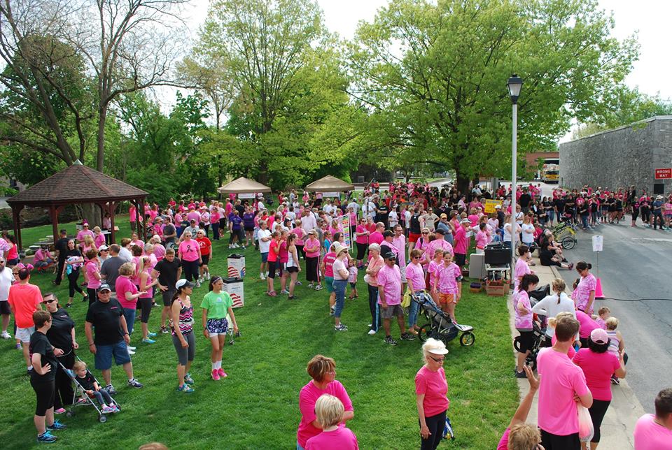
As we began coming out of downtown Chambersburg on Route 11 and saw Wilson College ahead, we also started to see peeks of individuals in pink cross an intersection a head of us. The police would let a car go between the Warriors in pink. As we turned the corner, we could see the steady stream of pink warriors walking on the right side of the road. It was obviously a run/walk for Breast Cancer. The runners were up front, because we missed most of them. Talking to the walkers are we passed, we discovered it was the Spring Cumberland Valley Breast Care Alliance and it was the 20th anniversary of their annual run/walk. It was evident that this event was a family tradition for many; a time to honor or remember their own “Pink Warriors” and start their children out walking and running at a young age. The course wound around and finished where it started, so we were able to see the masses walking and the finishers gathering!

Pennsylvania is rich in history too. In July of 1755, Edward Morris, the governor of Shippensburg ordered that a fort be built after he learned of General Braddock’s defeat at the hands of the French and Indians. His intent was to provide protection for the troops and colonists during the French and Indian War. So, over the next year, several buildings, a 70'-deep well, and a log palisade were built. Fort Morris was garrisoned until the early 1760’s, but preserved for several more years due to the efforts of Edward Shippen. Also, there is a record that an officer and eighteen provincial troops were stationed in Shippensburg during the winter of 1763-1764. On March 24, 1761, Shippen wrote, “I desire everybody in Shippensburg to take care of ye Fort for I will suffer a log of it to be thrown down on any pretense whatever.”
In Pennsylvania there are Amish and Mennonite homes and communities scattered through out the state. The portion we drove through today is no exception. I am just fascinated by their way of life, how they can remain so steadfast in their beliefs, traditions and way of life, while the lives around them are so different. We passed several horse and buggies on the road, from the open wagon with a father and son hauling goods, to a closed carriage with a family inside. The first one we spotted, Baby did not know what it was, she was very curious too! Maybe letting her ride in the front of the RV was not such a good idea?

In Newville PA along Route 11, in the middle of nowhere, we can upon the Cumberland Drive In, it has been “showing the stars since 1952.” The Cumberland Drive-in is one of only 338 drive-in theaters in America! It's affordable and a great place to bring the family for an evening of entertainment. That's why their movies are always family-friendly (Ratings of G, PG or PG-13). Watching a movie from the comfort of the driver’s seat with hundreds of your closest friends is a disappearing treat, but you can still find an iconic drive-in if you know where to look. This drive in made the list of the 11 drive-ins worth visiting in America. Here is the information from the article. “11. Cumberland Drive-In Theatre, Newville, Pennsylvania - This immaculately preserved drive-in has been in the same family since its opening in 1952. The Newville area’s dark skies help picture quality, so support a classic theater by treating yourself to a great American night out.”

We had to leave Route 11 and cross the Susquehanna onto 22/322 N because northbound Route 11 and 15 is closed due to rock slides. The closure is going to last 3 months! Change is good; we have never been up the east side of the river all the way.

Built on a bluff overlooking the Susquehanna River, Fort Hunter Mansion and Park has served as a war fort, a hub for frontier commerce, and an exclusive private estate. Now preserved and open to the public, it invites you to explore Pennsylvania's rich history. It commands a magnificent view of the Susquehanna River and Blue Mountains beyond. It was originally settled in 1725 by Benjamin Chambers, who later founded Chambersburg. Samuel Hunter, Chamber’s brother-in-law, inherited the well-favored property which included grist and saw mills. The bustling settlement thus became known as Hunter’s Mill. Faced with the mounting threat of the French and Indian War, the British built a series of small forts from Harris Ferry (Harrisburg) to Fort Augusta in Sunbury. Among these was Fort Hunter, ideally situated at a bend in the river, thereby serving as an alarm station and supply depot. The Fort was a 10′ by 14′ log blockhouse surrounded by a stockade and manned by volunteer soldiers, mostly farmers’ sons. In 1763, following the defeat of the Indian Nations, the Fort was left to decay. It was in 1787 that Captain Archibald McAllister, a dashing young officer who had served directly under General George Washington in the Revolutionary Army, bought the land.  This holding included the abandoned fort, Hunter’s mill, and farm.

Traveled on 147N, up the east side of the Susquehanna. It offered a great view of the beauty of the Susquehanna and a few small towns and naturally winding roads. The tree and rock lined route, gave way to some beautiful pictures, including this welcoming canopy of trees just budding out.

On Route 11 you will pass Fort Halifax Park, the first Saturday in May is their annual festival to honor the memory of the people and the Fort. As we passed there was a steady stream of cars entering to enjoy the one day event. Fort Halifax, one of a line of fortifications erected by the Provincial government along the Susquehanna River in 1756, it was built by Colonel William Clapham. He had 200 logs squared and cut 30 feet in length and preceded to have the fort built in two weeks "under guard of an officer and thirty men." It was a 160 feet square log stockade with four bastions and was an earthwork about 10 feet high surrounded by a ditch of equal depth. The fort was a sub post of Fort Augusta (at Sunbury), which was the largest of the Provincial forts. Fort Halifax was dismantled in 1757 and its garrison moved to Fort Hunter. A stone monument marking the site of this colonial fort along PA Route 147 just north of Halifax was erected. The area of the former fort is now part of the Halifax Township Park and Conservation area, which consists of 174 acres that is to be developed into a historical, passive recreation park.

The Cherry Blossom Festival in Washington DC was a little while ago, but driving in PA we see Cherry Blossom trees in bloom everywhere! One of the small towns we visited on Route 147 was Millersburg. The 27th annual Cherry Blossom Festival was in full swing! It is held down town and that made us get a scenic tour of Millersburg, as we were detoured off 147, as downtown Millersburg and the square was the location of the event. Sponsored by Millersburg Area Working Together (MAWT), the Cherry Blossom festival is touted as Millersburg's premier street festival.

We ended the day at Fantasy Island Campground in Sunbury PA to enjoy time with our friends, Jack & Jackie Laubach. Since they are both from the area, we will enjoy some great sightseeing. Here is one glimpse of it. Goodnight all.

Saturday, May 7, 2016

Florida to New York - 2016 - Day Four - SC to VA

This morning we departed Fort Chiswell RV Park. It is the perfect overnight stop. We have stayed before and will again! We got right onto Route 52 and right away got on US 11, which was on I-81. We traveled on I-81 for a while, until US 11 veered back onto its own course. It started out as a slightly overcast day, but the sun kept peeking through the clouds!

We passed through Troutville, Virginia. The name evokes the thought of huge trout swimming in the streams and rivers. But really, was the town named as a beacon to signal the fishermen to come! No, sorry to burst that bubble. The town of Troutville was established in 1956. In 1881, this area had no name. The railroad passed through and a station was built, there were three houses then which were occupied by brothers John, Jim, and George Trout, thus the area was called Troutsville. It became an important shipping center in the 1890s. In 1895, Troutsville was a thriving town with an active shipping point, farming, canneries, packing houses and factories. The name of the town was later changed to Troutville.

I often wonder how the Blue Ridge Mountains, got their name. Well, when you look at them, they really do look blue! I could look at these mountains all day and never get tired of the beauty of this mountain range! This time of year is especially beautiful, because the trees are just starting to bloom!

Established by Col. John Buchanan in 1811, the Town of Buchanan retains a blend of historic structures spanning almost two centuries. Standing as a testimony to successive generations, downtown’s historic buildings tell a story of each building, its occupants and their contributions to our community’s history and culture. You can explore elements of Buchanan’s Antebellum Canal Era, the site of Hunter’s Civil War Raid, witness the height of the Victorian era’s excitement as well as the arrival of the railroad and the twentieth century’s shift from horse and buggy to the model T Ford and beyond. My favorite thing to visit the Buchanan Swinging Bridge. It is the only one of its type to cross the James River. Portions of the bridge date back to 1851 as the Buchanan Turnpike Company Toll Bridge. On June 13, 1864, Confederate General McCausland burned the covered bridge to prevent Federal Troops under General Hunter’s command from crossing the James River. Following a series of replacement bridges, the Buchanan Swinging Bridge was constructed on the earlier piers in 1939. Due to its unique position between the Allegheny and Blue Ridge Mountains, Buchanan, Virginia is known as “Gateway to the Shenandoah Valley,” to those traveling north.

Natural Bridge – I great stop, it offers some amazing views. You had better like to walk, if you want to see the falls. But, there are some times of the year that the falls is only a trickle and you won’t know until you walk all the way to it! Oh well, it is still a nice walk after sitting in the RV. It is a must do, it you are in the area. There is ample parking for RVs closer to the road. It is not striped , so hopefully you are parking with other considerate RVers.

Enchanted Castle Studios offers a unique view from the road, a Viking on top of a windmill. The sad thing is it is not an attraction to visit or tour. They manufacture large fiberglass figures for the amusement industry. Once there was a studio tour here, but a fire forced it to close in 2001. The studio mastermind is Mark Cline. You can see some of his work in other areas around Virginia.
He also created the Elephant in front of the Natural Bridge Zoo on Route 11. He also is working on the Dinosaurs across the road from the Zoo and he created Foamhedge.
Foamhenge," a life-sized plastic foam replica of England's famous Stonehenge monument. Sadly, it has stood for 12 years and now it needs a new home. Originally installed an April Fool's Day stunt. News outlets report that artist Mark Cline must move the monument before Aug. 1 because Foamhenge sits on property that will become part of the new Natural Bridge State Park. The replica of the configuration of huge, upright stones in Wiltshire, England, has served as a local tourist landmark since it was unveiled. Cline says he built the free attraction to entice travelers off the road and has been impressed with its enduring popularity. He wants to give the replica to someone who is prepared to welcome a constant flow of curious visitors.

Virginia Gold, takes your mind to the nuggets of gold, big dollars, etc … but we are not the gold we blogged about yesterday. Virginia Gold is an Orchard, a family-run farm dedicated to growing the very best tasting Asian pears.  Asian pears are unique, but what makes Virginia Gold Orchard special is the fact that its pears are considered by many to be the best they have ever tasted. Many other pears - often shipped in from outside the United States - are picked green, days or weeks before they are truly ripe! They always pick there pears at the peak of ripeness, allowing the warm Virginia sun to give the pears their full, unique flavor. They then lovingly pack each box themselves at the orchard, by hand, to ensure only the very best pears reach you. Yum, can’t wait to get some when they are in season!

The monument to the 54th Pennsylvania Infantry Regiment is just north of New Market, Virginia. It was erected on October 25, 1905. A brass tablet beneath the monument explains the monument's rededication in 1984. The monument is next to the Bloody Cedars wayside marker, which tells the story of the 54th Pennsylvania at New Market, where they suffered the second-highest regimental loss in the battle. In 1984, title to this monument was given to the New Market Battlefield Park. The monument was originally dedicated on 25 October 1905 to the men of the 54th Pennsylvania Infantry, it now serves as a memorial to all who fought at the Battle of New Market on 15 May 1864.

McNeill’s Last Charge occurred just south of Mount Jackson, Virginia. History indicates that in the predawn darkness of 3 Oct. 1864, Capt. John Hanson McNeill led thirty of his Partisan Rangers against a hundred-man detachment of the 8th Ohio Cavalry Regiment that was guarding the Meems Bottom Bridge. The attack ended in fifteen minutes with most of the guard captured and McNeill, among the best-known Confederate partisan commanders, mortally wounded.

Last Indian Settler Conflict is the title on the wayside marker. It is on US 11, between Edinburg and Woodstock.
This history of the marker itself is interesting, but first this is what it says: ‘LAST INDIAN-SETTLER CONFLICT: A series of conflicts between settlers and Native Americans, including the French and Indian War, the Cherokee War, and Pontiac’s War, occurred along the western frontier of the colonies. The last documented clash in the Shenandoah Valley took place nearby in 1766. A small band of Indians attacked the Sheetz and Taylor families as they fled for safety to the fort of Woodstock. Mathias Sheetz and Taylor were both killed, but their wives used axes to fight off the Indians and escape with the children.’ I learned more about this marker in an e-book called ‘Lies Across America: What American Historic Sites Get Wrong’. In this case, there is a new sign that corrects an earlier version of the marker, which was hit by a snow plow in 1994 and had to be replaced. Here's what the old marker said: ‘LAST INDIAN OUTRAGE: Here, in 1766, took place the last Indian outrage in Shenandoah County. Five Indians attacked two settler families fleeing to Woodstock. Two men were killed; the women and children escaped.’ They used "Conflict" instead of "Outrage" in the title, all is politically correct now … why can’t we let historical markers be and take them at face value for the era they are representing?!
If you go through Woodstock Virginia, you must stop at a small garden in downtown. At first glance it looks like there is a stone hiker standing there. The garden is called “Jane's Garden” in honor of Jane Beasley, a former Enhancement Coordinator, for all of her hard work and dedication in the beautification and improvement of the Town. To increase its beauty, the Town of Woodstock has placed our first piece of public art in Jane's Garden. The theme of the piece at this location is meant to "Capture the Valley" and PAC-Man was chosen because he, or is it a she, represents people who long ago settled in our beautiful Shenandoah Valley. In the words of PAC-Man's talented sculptor, Craig Gray, "He is symbolic of the travelers who walked across our country to 'capture' better places to live, work, and raise families. He could be about life and our experiences... the sharp edges rounded as we make our journey."  Better hurry, if you want to catch a glimpse … PAC-Man will only stand still for so long … in August of 2017, he will walk on!

On Route 11, it is a quick trip through West Virginia and across the Potomac into Maryland. It is interesting how Route 11 transforms itself the entire length! It is a winding two lane road, with no shoulders. At other times, it is a four lane divided highway with majestic trees in the median. Lastly, it is joined with Interstate 81 and takes on the “fast pace” that many of us live today. Personally, we prefer the slower pace of the two lane Route 11. I love to pass through the small towns that take you back to the slower pace and family atmosphere that surround these towns.

Spending the night in Williamsport MD at Hagerstown Antietam KOA, we have been here before and love this place! Sits along a creek and offers loads of character!

Thursday, May 5, 2016

Florida to New York 2016 - Day Three - SC to VA


Everyone was up early this morning ready to hit the road! We departed the Cambridge Camden RV Park this morning and headed back north on Route 601, into the town of Lugoff, NC. The RV park is nothing fancy, but offered a great respite off the road. We were entertained by a mother cat trying to get her two kittens to follow her as she tried to relocate them from under a motorhome. She worked very hard at it and finally after several hours of back and forth and coaxing ... she got both kittens to follow her.

Right on Route 601 is the RC Pit Cross Track, an off-road supercross track. It reminded me of the RC track the residents and guest built at Majestic Oaks RV Resort. There are many lanes and many more humps and jumps and a few straightaways. There is a large raised driver’s stand and several spectator bleachers. The surface is hard packed clay. There were only a few racers this morning!

Camden South Carolina is home of the Battle of Camden, that was fought August 16, 1780, during the American Revolution.  The Battle of Camden was a lopsided victory for the British. Despite the spread of dysentery among his men, Continental General Horatio Gates chose to engage British General Charles Cornwallis’s forces. The illness depleted the Patriot advantage in troop numbers, and the British pressed forward aggressively as the only side in possession of bayonets. With the encounter resulting in nearly 2,000 Patriots killed or taken prisoner and heavy losses of artillery, Gates was removed from command and replaced by Nathanael Greene.

On Route 601 there is a huge mining operation, we saw countless trucks entering and exiting. Located in Lancaster County, the historic Haile Gold Mine was one of the first operating gold mines in the US. Established long before the gold rush of California, the mine was discovered in 1827 by Benjamin Haile and has been operated on and off for nearly 200 years. Today, it is owned by OceanaGold an exploration and development company focused on becoming a producer of precious metals in the United Sates. The mine is confirmed to contain 2 million ounces of gold reserves. Utilizing the most advanced technology and mining techniques, they are investing over $300 million to build the mine.  On average they spend about $3 million per month locally through labor and the purchase of local goods and services. That astounding figure doesn’t even account for the individual spending of our employees and contractors who will also make a range of purchases, from new homes and new cars to meals and gasoline. Wow, this mine has been a big boost to the economy and unemployment!

Have you ever seen a 40 Acre Rock? On Route 601, between Kershaw and Pageland is the Flat Creek Preserve. The most prominent feature is the massive rock that you can walk across and admire the scenery. It is named for a massive granite standing rock that is actually closer to fourteen acres in visible size. The rock is a celebrated example of granite outcropping in the Piedmont, is one of several exposures throughout the region. Many of the others, though, are mined for their valuable high-quality granite, the state's official rock. Unfortunately, vandals have defaced much of the main rock with spray-paint. However, it is still an amazing sight!

Crossing from SC into NC does not offer much fanfare. No welcome center, just a small sign after a gas station and a small sign.

In Midland North Carolina you can find the Reed Gold Mine Historic Site. The Reed Gold Mine is the site of the first documented gold find in the US. From this discovery, gold mining spread gradually to nearby counties and eventually into other southern states. During its peak years gold mining was second only to farming in the number of North Carolinians it employed. The estimated value of gold recovered reached over one million dollars a year. North Carolina led the nation in gold production until 1848, when it was eclipsed by the great rush to California. Who knew? Everyone always thought that California was the only great gold rush!

Our route today, took us through Historic Salisbury, why makes Salisbury so historic? Their chamber of commerce wants you to experience authentic North Carolina heritage in many unique ways while savoring the charm and character of an area rich with centuries of history, adventure and discovery.  From the early days of Daniel Boone, the African American Heritage Trail, to the civil war history and Historic Downtown Salisbury, there is something to interest everyone.

We went through Boonville NC and thought of our friends Claude & Shirley Riegler. Here is a picture of the “southern” Boonville … just for you northern Boonville folks!

I wish I could have snapped a picture of this … believe it or not … near the town of Dobson North Carolina, there was a home with beautifully manicured flower beds and in one of the beds was a life size wood carving of a character from the ‘Plant of the Apes.’ I kid you not … I stared at it too long to figure out what it was to capture a picture!

In Mt Airy NC, Route 601 ends and we navigated onto Route 52. Mt Airy is Hometown of Andy Griffith and host to the annual Mayberry Days celebration and every Andy Griffith, including many resturants. There is Aunt Bea Barbeque & Catering; Goober’s 52; Barney’s Café and Mayberry Meats & More.

Starting into Virginia, we knew we were getting closer to the Blue Ridge Mountains, because we started to climb in elevations. It is a winding narrow road for most of the way, but offers some beautiful sights, if it was not raining! Baby Geek-E-Bird was not a fan of the winding roads. Our Winnebago Aspect with a Ford V-10 engine, towing our Jeep, had no issues on the climb and the decent.

Do you wonder where the slogan ‘Virginia for Lovers’ came from? I always have! The phrase came from a creative team headed by George Woltz of Martin & Woltz Inc. According to Martin, a $100-a-week copywriter named Robin McLaughlin came up with an advertising concept that read, "Virginia is for history lovers." For a beach-oriented ad, the headline would have read, "Virginia is for beach lovers"; for a mountains ad, "Virginia is for mountain lovers," and so on. Martin thought the approach might be too limiting. Woltz agreed, and the agency dropped the modifier and made it simply "Virginia is for Lovers." The first ad mentioning the new slogan ran in the March 1969 issue of "Modern Bride." The phrase was considered bold and provocative, but it was also just plain smart from a marketing perspective.  Virginia is for Lovers of . . . No one knows exactly why "Virginia is for Lovers" has been so durable, but part of the mystique of the slogan is that it has meant many things to different people. Today, a new generation is discovering love for Virginia’s mountains, beaches, history, theme parks, vibrant cities, outdoor activities, sports and hospitality. And the love story continues.

Field of Flowers at Pleasant Hill Farm offers a cut your own flowers; fill a Mason jar for only $7. The farm is located in eastern Wythe County, in beautiful Southwest Virginia. The land in this part of Virginia features mountains, hills and rolling farm land. It offers spectacular views of the Blue Ridge Mountains. In the spring, they have Daffodils and Tulips, during the remainder of the year, they offer many varieties of annuals and perennials for you to choose from. There are over 50 large flower beds of blooming annuals and perennials spread over 5 acres. They also host weddings and other events year round!

We ended our day at Fort Chiswell RV Park in Max Meadows VA. Many of our friends have stayed here as they made their ways north … Patty & Ron Stevens; Jack & Jackie Laubach and Bob & Judy Carron before us! I am sure there will be more friends behind us! Happy Cinco De Mayo to everyone! I enjoyed a little "Rita" in honor of the special day!


Wednesday, May 4, 2016

Florida to New York 2016 - Day Two - Georgia to South Carolina

Departed Mossy Oaks and headed North on US 301 again today. Mossy Oaks got its name from the massive live oak trees at the entrance of the park. These are hundreds of years old, the mighyt oaks have large amounts of moss hanging from their huge limbs. This park offered us the quietness and tranquility of a restful forest of pines, cedars, oaks and other hardwoods.

Along US 301, where the sign for the park is located there is another sign for a local BBQ joint. Hillbilly’s Grill & BBQ some locals call it Hungry Hillbilly Grill & BBQ. The reviews are good and the prices are average. Next time, we will have to check it out! Both of these are just south of Jesup. Jesup, Georgia is home to the oldest Drive-In Movie Theater in Georgia. It is very well maintained and is playing current movies! Their motto is “See the Stars under the Stars.” The current owners have owned it since 2012. Renovations they completed were all to improve the experience of the Drive-In by enhancing the nostalgic ambiance. They added décor from the 1950s era, including carhops (dressed in 50’s attire) who can take food orders from your car. The Jesup Drive-In is a real treasure! In 1958, there were more than 4,000 drive-ins in operation across the US, today only 338 remain.

GOD was watching over us today, and that was evident in the rays of sunshine that peaked out through the early morning clouds. It was a perfect morning to travel. It was light, but the sun was not beating down on us. Some of the roads we drove on today had seen rain last night, but we were dry where we stayed. Some of the rains must have been heavy, because we had standing water on some side roads.

In downtown Glennville, there is a mural on the wall that depicts all that makes Glennville great, including the cotton crop, the train that moves the goods and the famous Vidalia Onion. Tattnall County, which includes Glennville, is the largest and grows more Vidalia Sweet Onions than any of the other Vidalia Sweet Onion growing counties, contributing approximately half of the entire state crop each year.

US 301 takes us through Glennville Georgia. Glennville’s biggest annual event, the Glennville Sweet Onion Festival, is in its 40th year in 2016. We are just a few days ahead of the big event … I am sad, but Charlie is glad! It is held on the second Saturday of each May and celebrates the harvesting of the famous Vidalia sweet onion crop. The day begins with a “sweet” onion run and walk and a downtown parade, then on to the State Farmers’ Market on Highway 301 South for an array of arts and crafts, delightful entertainment, children's rides and games, delectable food (that includes fried sweet onion rings and blooming onions) of course!

We passed by many freshly plowed fields. Baby wanted to know why the dirt was red? There are over eighteen Georgia Grown Trail 301 locations in and around Glenville and Tattnall County. I found the Armstrong’s Cricket Farm, fresh produce at Georgia Grown U-picks DC Durrence Farms and Ray Farms. Just off 301 is the Watermelon Creek Vineyard. Hmmmm, sounds good to me! Isn’t there a country song about the Watermelon Crawl … could that be from Watermelon Wine? I would love to drive the whole trail and stop at each place, but it would have to be without the camper … let the Adventure Begin!

I wish I could have gotten a picture of this one! It had “Vinny’s Bargain Barn” stenciled on the roof. It is located on US 301 just outside Statesboro, Georgia. All I can say, is “one man’s junk, is another man’s treasure” … Vinny either had a bunch of junk or a million treasures! The piece that caught my attention was a Shoney’s Big Boy a top one of the roofs of the building, plus all the other large pieces of “treasure” around the building. I would be afraid to enter … but the American Pickers might venture inside!

As you cross the Savannah River, you can see the old swing bridge that used to be used to cross the river. This closed off section of the old highway has been converted by the state of South Carolina into a nice pedestrian walkway. At one time it was nicely shaded by the trees, now it is more overgrown and those branches have overtaken the bypassed highway and elevated bridge. The almost 3 mile pathway would allow you to walk right out onto the old bridge and look down into the Savannah River.

Before crossing the GA / SC State line, you see the Georgia Welcome Center. Surviving many rounds of budget cuts, Sylvania's welcome center, believed to be the nation's oldest continually operating roadside visitor center, soldiers on. It celebrated its 50th birthday in January of 2012. It was placed on the National Register of Historic Places at the end of 2011. This old 1962 relic perfectly captures the space age architecture that was so prevalent in the late 1950s and early 1960s.

Along the embankment of Interstate 26, where US 601 crosses over the Interstate you can see a patriotic rock formation of “USA” and an American Flag. This tribute to the US was created by SC Department of Transportation workers after 9/11. It looks as vibrant and alive today as it did the year they created it. Being a retired military officer, it warms my heart every time I see something a patriotic as this!

 
We followed along the back side of Fort Jackson and ended the day at Columbia Camden RV Park, just outside Ft Jackson SC. When we pulled into this park, we remembered that we had been here once before. It was when we had our truck camper and we were driving after dark. We found this place and paid at the “honesty box” check in and went to a site. Getting here in the daylight revealed that it is a quaint, well maintained family owned park. They have 83 sites with a few pull through sites, perfect for our overnight stop.
Each site even has 2 Adirondack chairs, which we enjoyed this afternoon in the nice breeze and sunshine. Maudine and Maynard enjoyed them too! Good Night!

Tuesday, May 3, 2016

Florida to New York to see Family and Friends


We started out our two lane adventure by heading north on Route 301. We are planning on taking 301 and 601 for most of this portion of our adventure. We have been seeing these pretty purple flowers along the road side for a few weeks now, as we head out of town I spotted these taller ones!

Today I learned about the history around the area we live. If you are a history buff, the Dade Battlefield Historical Site is the perfect stop for you. It is the site of the Dade Massacre. After Christmas in 1835, around 110 cold, tired soldiers marched north, headed to Ft. King, near present-day Ocala. Because of the cold, most of them had their muskets and ammunition buttoned beneath their heavy overcoats. They had been marching for five days and their commander, Major Francis Dade, had promised three days off to properly celebrate Christmas upon their arrival at Ft. King. The march had been quiet so far and there was no sign of the Seminoles. It is believed that Major Dade, ordered the scouts covering his flank back to the main column in order to move faster.
Along a half-mile stretch of trail that cut through pines, palmettos and tall grass, 180 Seminole warriors lay in ambush, an act of war for which the tribal leaders had been preparing for more than a year. Chief Micanopy fired the first shot, reportedly bringing down Major Dade himself, after that, the other Seminoles to begin firing. Within moments, half the American soldiers had fallen. The survivors regrouped and, under the command of Captain George Gardiner, drove the Seminoles back temporarily and managed to construct a makeshift battlement of logs. By the end of the day, however, only 2 Americans survived and the Second Seminole War had begun. The Dade Battlefield Historic State Park commemorates this battle and honors the participants on both sides. Every January features a reenactment of the battle, which is historically accurate and exquisitely detailed.

A good portion of our travel today was through Sumter County. Did you know the Sumter County seat has been located in more than 4 towns? Sumter County was officially created by the legislature in 1853 and Adamsville was originally designated the county seat. In 1858, the center of county government moved to Sumterville.  In 1868, the legislature again moved the county seat, this time to Leesburg.  In the late 1870’s, Leesburg became part of the newly created Lake County and Sumter County was directed to vote on a new county seat.  In October of 1881, the citizens voted for Sumterville to become the county seat once again.  After two years of legal wrangling, the legislature recognized the election and work began on a new courthouse. Less than 20 years later, in January of 1909, fire destroyed the Sumterville courthouse and virtually all the records stored within.  Again the legislature ordered an election, and again political in-fighting delayed the process.  Finally, in 1912 and by a margin of only 12 votes, the citizens chose Bushnell over Wildwood as the new county seat. There is a historical marker commemorating the old Sumterville courthouse. It is collocated with the Sumterville Community Center and Historical Site. 

Every time we drive the two lanes in Florida and southern Gerogia, we amazed by the grandeur of beautiful, draping Spanish moss decorating the huge live oak trees. While the hanging moss has a mysterious appeal for people not used to seeing such natural beauty, Spanish moss-draped live oak trees thrive in the southeastern United States. It is also native to much of Mexico, Bermuda, the Bahamas, Central America, South America and the West Indies as well as being naturalized in Australia and in the French Polynesia.

There is a charming and somewhat spooky appearance of the silver-gray strands, hanging like natural Halloween decorations. It creates images of old plantations, bayous and the swamps, like seen in movies. When it sways in the wind at night, this tangled ‘tree hair,’ as the Native Americans called it, is both eerie and intriguing. French explorers dubbed it ‘Spanish Beard’ as an insult, so the Spanish then named this moss ‘French Hair.’ This plant, is not even a true moss. It’s a distant member of the pineapple family and grows until it looks like it’s dripping from large trees. It can grow over 25 feet long. It grows wherever the climate is warm enough and has a relatively high average humidity. It has been introduced to similar locations around the world, including Hawaii and Australia. It propagates both by seed and by fragments that blow on the wind and stick to tree limbs, or are carried by birds as nesting material.

Where US 301 and US 441 run together in Ocala, the roadway is designated the Rosa Parks Memorial Highway.  US 301 and 441 were selected to honor parks because it is a national highway. It is hoped that other communities along US 301, those north and south of Alachua and Marion counties, will move to dedicate the road to Parks and keep the designation going around the state and nation.

The Purple Things We See … I saw a purple motorcycle, a purple car getting gas, a purple cargo van for sale, a purple fence and I found a Purple Rooster in front of Ceremonial Fireworks in northern Florida. He is an oversized fiberglass rooster. Here you go lovers of purple! Sorry, none of the other pictures turned out!

Crossing the FL/GA line, I was driving! I did my turn today! For everyone that is wondering, I highly recommend taking the driver confidence course at Lazy Days in Seffner, FL. I drove from Starke until after we crossed the FL/GA line.
We now have more than enough navigators for this trip … we have the GPS, myself, the map and we have our Geek-E Bird, Baby. She wanted to ride in the front, so Charlie stuck her on the dash and she just sat there and enjoyed the view all day! Naturally she tried to tell me where to turn!

Driving along 301 in Georgia , we found a 301 Trail Stop sign. What does that mean? Elected officials and members of the Georgia Grown coalition, brought the Georgia Grown Highway 301 Trail to fruition. There are 55 trail stops being promoted as tourist destinations along the 8-county route. The trail, which runs from Charlton County on the Florida line north through Brantley, Wayne, Long, Tattnall, Evans, Bulloch and Screven counties on the South Carolina border, they feature agri-tourism venues, local restaurants, art galleries and unique shops. We won’t be able to stop at all 55 … but might catch a few!

We traveled along the Upper Santilla River for several miles today. There were many fishing access points and a few boat launches running alongside of 301. The Satilla River is considered to be one of the most scenic and natural rivers in south Georgia.  Originating in Ben Hill County, the river takes a free flowing and winding course for 260 miles before emptying into the Atlantic Ocean.

 
Mossy Oaks RV & Campground is our overnight spot. It is a gem in the rough, just outside Jesup Georgia! It is about 5 miles off 301, near the intersection of 341. They have about 30 sites; the majority of them are pull through. The roads are dirt and gravel, but the sites are shaded and spacious. All have a picnic table and fire ring.
 
There is a wide nature trail and a beautiful fishing pond. I watched many fish jump, but I could not get them to cooperate for a picture! But the reflections on the pond are amazing! It is a Passport America park and our cost was $15.00. The owner met us in the driveway, took us right to our site and even completed our registration at his “mobile office.”