Sunday, May 15, 2022

Thursday, May 12th, 2022 … Two Lane Adventures Continue!

Today we left Modoc SC to travel to the SC Good Sam Rally in Cleveland SC. We traveled on US 221 and SC 28, which bears the SC Heritage Corridor Nature Route markers. These signs populate the Scenic Byway, helping travelers to navigate the intricate highway system. The nature route is one of two parallel corridor-wide routes that run the length of the Heritage corridor to act as entrances to the corridors regions. The routes will connect and tie the 14 countries into one tourism destination. The nature route is a gateway to a wide variety of South Carolina’s natural resources. Beginning in the waterfalls and mountains of Table Rock and the Mountain Bridge Wilderness Area, the nature route winds along Russell and Thurmond Lakes and on to the Savannah River. The route follows the Edisto River, the longest free flowing black water river in America, until it reaches the ACE Basin and coastal plain of the Low country.

We came into Plum Branch, SC. Plum Branch got its name from the first church Plum Branch Baptist constituted in 1785, and built near the little stream Plum Branch. In the town was Bracknell's Store, owned by John Bracknell, opened in 1902. It was your typical general store. Providing customers everything they needed for day to day living. It was built parallel to the railroad tracks, the main stay of most towns.

It's what is painted on the side of the building that brings the chills up your spine. "This building may fall, but the quality of our merchandise will never." Although, from outward appearances, the building is in good shape for the age! Oddly enough, the name painted on the building is E.C. Rice, while the building has large letters affixed to the roof indicating Bracknell’s.


There was also a freshly painted mural on an outbuilding of the railroad in this lonely town of Plumb Branch. I tried to find any info

In February, 1852, William Burkhalter Dorn discovered the second-richest vein of gold in South Carolina history on the site of the present town of McCormick. At that time the land was owned by Dr. John Wardlaw Hearst, a relative of the famous family of newspaper fame. Dorn’s Mine, as the settlement was called, had a dozen families living nearby when Cyrus Hall McCormick, inventor of the reaper and "father of farm mechanization," bought the gold mine and land for $20,000. When the mines proved to be unprofitable, he purchased stock in both the Augusta & Knoxville Railroad and the Savannah Valley Railroad and through his influence, both of them intersected on his land in McCormick. For the town, he ordered forty acres surveyed and laid out in squares, which were alphabetically listed and divided into 30’ by 90’ lots. He auctioned the lots and gave property for the churches, school, and cemetery. Cyrus McCormick never visited his property, but his wife Nettie took on the community as her personal social project.


As we departed McCormick, we spotted cheap gas! Too bad the station has been closed for years, especially with those prices!

At 832 feet, Parsons Mountain holds the title of the highest point in the general geographic area surrounding Parsons Mountain. Mr. James Parsons, the mountain's namesake, acquired it through a land grant in 1772. In the mid 1800s, gold was discovered on the mountain, further adding interest to the area. Long before Mr. Parsons, American Indians lived in and used these rich, productive forests. Settlers in the 1770s worked the land, obtaining what they could from agricultural practices, and cleared most of the timber. By 1920, severe soil erosion created abandoned fields, deep gullies, and soil-filled streams. From this worn out land, the Sumter National Forest was started in 1936. The Civilian Conservation Corps (CCC) planted trees, repaired gullies, fought wildfires, and built roads. In 1935 the CCC built the fire tower on Parsons Mountain and in 1940 they began construction on this lake and recreation area. From its beginning, the Sumter National Forest has provided clean water, timber, wildlife habitat, jobs, and recreation sites for its communities. Parsons Mountain Recreation Area is an example that if resources are used wisely they can be enjoyed generation after generation.


In Anderson SC on SC 28, we passed Anderson's one & only Bison Farm. There was no name on it, but those big guys are definitely buffalo or bison!

We drove by this place and all I can say is, damn … I wish it was Saturday! What caught my eye was Breazeales Grocery Bluegrass. It’s a store that hosts bluegrass jams! The store was opened in 2007 and they have been in operation almost every Saturday since then. A couple opened the store for their son, Martin. They wanted him to have a place to develop his banjo skills and enjoy some good ole' fellowship with other musicians. It doesn't hurt have a place where people could come and play music together like the good ole' days. Sadly, Martin passed away in a boating accident in 2018. His memory is kept alive through the fellowship and music that is played and experienced every Saturday night at Breazeales. There are not many groceries, they sell: Hats, Exclusive Bluegrass Blend Coffee, Shirts, Instrument, and anything in the store you wish to purchase.


We passed through downtown of Historic Pickens, SC. The town of Pickens was founded in 1868 and named for the Revolutionary War hero General Andrew Pickens. Scottish-Irish settlers were the original inhabitants of the Pickens area, with a few traders who lived among the Cherokees. When the new Pickens was being created, Elihu Griffin offered 40 acres of his land for the courthouse; it was this land being offered for sale in the 1869 handbill. On June 15, 1869, a handbill distributed in South Carolina’s Upcountry advertised the “Last Sale of Town Lots” for the new county of Pickens. The ad stated, “The location is most desirable, one situated on a beautiful plateau and surrounded by a fertile region, with thrifty inhabitants and the village rapidly growing.”  


Just outside of the town center of Pickens is the Hagood Mill Historic Site. It is home to over 50 acres to explore. It is also on the National Registry of Historic Sites. It features an 1845 gristmill, restored log cabins, blacksmith shop, cotton gin, moonshine still, nature trails, and a gift shop featuring local crafters, musicians and authors. They host musical performances, private events and other community events. During musical and community events, you can see the grist mill in operation, a variety of living history demonstrators and an artisan market. Located on the same grounds is the South Carolina Petroglyph Site, the state's only protected and most accessible collection of rock art.


We saw our first brown bear as we neared the RV Park. I hope this is the only one we see!

Arrived at Palmetto Cove RV Park, our home for the next 3 night and 4 days. We will enjoy the SC Good Sam Rally, we always do!


Sandy and I dipped our toes into the cold, cold stream that runs behind the campground. We sat on a big, big rock and enjoyed the cool refreshing water!

Stay tuned for more Two Lane Adventures!


Saturday, May 14, 2022

Wednesday, May 11th, 2022 … Two Lane Adventures Continue!

I told you we were coming back to the town of Harlem. We visited the Harlem Museum and Welcome Center, Home of the Laurel & Hardy Museum. The Harlem Museum and Welcome Center opened October 5, 2019 at the Oliver Hardy Festival in Harlem, Georgia. 

The Harlem Museum provides the history of the city and a bit about Columbia County. The beginning of Harlem was a dream of two men who wanted a liquor-free town. When the Georgia Railroad was built from Augusta to Eatonton, Georgia in 1835, Saw Dust was a main stop.  Saw Dust was the booming lumber town, founded in 1840, situated a mile from where Harlem is today.  Travelers often stayed overnight in the town, which sold liquor and bore a reputation of being a little wild.

In 1857, Andrew J. Sanders – one of the first graduates of Medical College of Augusta – moved to the area.  Hoping to increase the population, Dr. Sanders sold his land for a dollar an acre. He also donated land to build Harlem Baptist Church, Harlem High School (now the Middle School) and Harlem Methodist Church.  He was the first mayor of Harlem and served in that role for nine years.Around 1865, railroad engineer Newnan Hicks decided to quit his job when he was asked to work on a Sunday.   He wanted to start a town that didn’t sell liquor – unlike Saw Dust – and decided to build a house near Mr. Sanders. So Harlem was founded on October 24, 1870.  It was named by a New York resident visiting relatives who thought the town resembled Harlem, New York, the elite artistic area near New York City. Lined with big oaks and blessed with good drinking water, the town was a haven for many Augustans, especially during summer outbreaks of smallpox and cholera, said Patricia Moore, whose ancestors were among the first residents. Saw Dust was absorbed by Harlem in 1887, and nearby Cerlastae, another settlement, did the same in 1906.

In 1913, Harlem had about 500 residents and boomed with an oil/fertilizer plant, the Columbia Opera House, Hicks Hotel, electric lights along the road and in homes, two drugstores, three meat markets, two gin mills, a cotton warehouse, three hardware stores, two grocery stores, two clothing stores, a newspaper and ten passenger trains daily, according to the Columbia Sentinel. But on August 24, 1917, a fire of unknown origin destroyed the plant, Opera House and several buildings.  The blaze caused $60,000 in damage. The town tried to regain its vigor through the Georgia Railroad.  In 1933, the community of Berzelia merged with Harlem. But Harlem remained small and family-oriented, and people could tell if a family had money by whether the street in front of its house was paved. Until 1940, all the streets weren’t paved.  The Columbia Theatre ran the latest movies from 1949 to 1963.  The Georgia Railroad Depot that was built in 1896 was torn down around 1965.  The last passenger train came through Harlem on May 6, 1983. 

Harlem today has about 3000 residents, and the first weekend in October each year draws tens of thousands of people to visit the downtown area and celebrate the life of the portly comedian who was born in Harlem in 1892, Oliver Hardy. Oliver Norvell Hardy was an American comic actor and was one half of Laurel and Hardy, the double act that began in the era of silent films and lasted from 1926 to 1957. He appeared with his comedy partner Englishman Stan Laurel in 107 short films, feature films, and cameo roles.

The Laurel and Hardy Museum of Harlem, Georgia opened in 2002 and is the ONLY museum in the United States dedicated to comedians Stan Laurel and Oliver Hardy. Harlem, Georgia is the birthplace of Oliver Hardy. Admission is free, and visitors can see a variety of Laurel and Hardy memorabilia, view their favorite Laurel and Hardy films, and purchase souvenirs.

Dedicated to the one of world's greatest comedy duos, Laurel & Hardy, the museum contains artifacts, memorabilia, and a theatre room to watch any of the 106 movies they made together. The display items have been donated by fans from around the world, and each year thousands come to Harlem to pay homage to "The Boys." Harlem is the birthplace of Oliver Hardy, the portly half of the world-famous duo. We hung around and watched a short or two.

This was the third time we had tried to get to this museum and we were finally successful! The first time we tried, the old location was closed and they were moving to the new location. The second time we tried, the museum was relocated to the new location, which is the old theatre, but it was closed due to COVID. I was stoked to be able to finally make it inside!

After Harlem, we headed to the northeast side of Augusta to Good Earth. What exactly is Good Earth? Easy! They are an enclosed farmers market offering fresh produce, unique local products, seasonal plants, and more for all year round. They find produce and plants that are grown locally according to the seasons, and they make them available to the community. They do business with local farmers who provide the highest quality products and hire local people to be a part of their team. 

Let me tell you about our Corps of Engineer campground. Modoc Campground is a popular campground on J. Strom Thurmond Lake, just 5 miles from the Thurmond Visitor Center and Dam. It’s about a 70,000 acre lake with more than 1,000 miles of shoreline. The lake provides excellent boating, water skiing, swimming, fishing, hiking and picnicking. 

Modoc campground is one of the only COE facilities on J. Strom Thurmond Lake that only offers camping and no other facilities to anyone who is not camping there. For those that are camping at Modoc, you have access to a private beach, dock and boat launch. The sites are spacious, tiered and most provide water access. All of the campsites are on both sides of peninsulas. Some of the peninsulas are almost a mile long from the main park. I used this fact to create some great walking routes during our 3 days here!


Of course, we had a fire with hot dogs roasted on it!

Stay tuned as we travel along!

Friday, May 13, 2022

May 10th, 2022 … Two Lane Adventures Continue!

We departed Folkston Georgia on US 301 N and quickly turned onto US 1. Folkston is home to The Okefenokee Swamp. It is a shallow, 438,000-acre, peat-filled wetland straddling the Georgia–Florida line. A majority of the swamp is protected by the Okefenokee National Wildlife Refuge and the Okefenokee Wilderness. It is world renowned for its amphibian populations that are bio-indicators of global health. More than 600 plant species have been identified on refuge lands.

   
We headed into Waycross GA. We missed the truck route and cruised through the heart of Waycross. Along the way, we passed Millie DeShazo Triangle and drove on Ozzie Davis Parkway. Millicent Jackson “Millie” DeShazo, she opened a florist shop and became known as the “flower lady” of Waycross. After retiring she was involved in the Beautification of Waycross and Ware County. She was honored to have the Millie DeShazo Triangle named for her. Ossie Davis, a veteran actor, playwright and film director grew up in Waycross, Georgia.

After Ware County, you enter Bacon County. It was founded in 1914 as the 151st county in Georgia. No, Bacon County is not named after the popular breakfast meat … although I swore I could smell bacon! It received its name in honor of Augustus Octavius Bacon, a four- term US Senator who also served as President Pro Tempore in 1912. Alma, the only incorporated town within county lines, became the county seat. Alma was founded in 1900 as a stop on the Atlantic Coast Line Railroad. It was incorporated as a city in 1906 and designated seat of the newly formed Bacon County in 1914. There are two theories about the origin of the name of the town. The first is that it was named for the wife of a traveling salesmen, Alma Sheridan; the other is that it was named for the initial letter of the four state capitals Georgia has had: Augusta, Louisville, Milledgeville, and Atlanta.

What is the #1 fruit crop in Georgia? Peaches, Peaches, Peaches … everyone who said peaches is wrong! Alma is also the Blueberry Capital of Georgia, and blueberries are the #1 fruit crop in Georgia! Alma is also home to the Georgia Blueberry Festival and tons of growers! It is a locally organized festival. Its goal is to honor and recognize the importance of the blueberry crop to Alma and Bacon County and to thank those who are involved in the production of the blueberries. The Festival provides entertainment, activities, and food to local residents and visitors. 2022 is its 46th year!
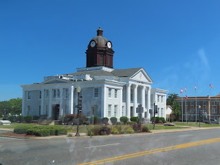
As we arrived in Baxley, you are greeted by a beautiful Neoclassical style courthouse. The Appling County Courthouse was built in 1907–1908 at a cost of $50,000. It is constructed of limestone and concrete. Appling County is named for Lieutenant Colonel Daniel Appling, a soldier in the War of 1812. Appling County, the 42nd county created in Georgia, was established by an act of the Georgia General Assembly on December 15, 1818. For a time Appling County was known as the turpentine capital of the world. Residents also constructed timber rafts from cut trees destined for the Darien sawmills. These rafts reached proportions of 25 feet wide by 175 feet in length. A unique rafting and turpentine culture grew out of Appling County.

We passed the Hatch Nuclear Power Plant. It sits on almost 2,500-acre site, along banks of the Altamaha River, from which it draws its cooling water. It was the first nuclear power plant built in Georgia. The plant is home to two boiling water reactors. It has been operating since 1974. The plant is operated by Southern Nuclear on behalf of co-owners Georgia Power, Oglethorpe Power Corporation, Municipal Electrical Authority of Georgia, and Dalton Utilities. In 2018, Hatch became the first commercial reactor in the US to test newer types of fuel developed by the US Department of Energy, which are said to be more accident tolerant.


Right across from the power plant is an RV park, looking at the name I am not sure it is a comforting and welcoming sign!?


As we drove through Georgia, they are turning our Two Lane Adventure into a divided Two Lane Adventure in each direction. We are still OK traveling this way, because it is not an Interstate!


Did you know that there are only two cities in the world named Santa Claus? Well there was three, but one is a ghost town in Arizona. So, there are only two with inhabitants! The uninhabited Santa Claus was located in Mohave County, Arizona. It is now a ghost town that was abandoned 1995. Nina Talbot founded the town in 1937, which attracted attention for its holiday-themed businesses such as the Santa Claus Inn and a children's train called Old 1225. Its popularity soon declined, and the last operating business closed in 1995. One of the remaining Santa Claus, Indiana is located in Spencer County with a population of 2,500. Founded in 1854 as Santa Fe, the name was changed two years later to avoid confusion with another Indiana town of the same name. The post office is now the only one bearing the name Santa Claus and gets thousands of letters to Santa each year.

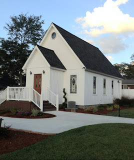
We traveled through Santa Claus, Georgia, It is located in Toombs County with a population just short of 200. This Santa Claus is too small for a post office, but it still has Candy Cane Street and December Drive to fit the seasonal theme. The small area is dotted with themed business and decorated with garlands and other holiday iconography year-round. There is a beautiful garden and tiny chapel built by local volunteers.


The city of Louisville served as the state capital of Georgia from 1796 to 1806. It was a center of trade, legislators, and political influence. The Jefferson County courthouse, built in 1904, stands on the site of Georgia's first permanent capitol building.

Stuckey’s, the onetime iconic roadside chain known for its teal roofs and pecan rolls, is back in the business of making its own candy. The change occurred in 2021 with the purchase of a family-owned Wrens operation that includes Atwell Pecan Co., Thames Pecan Co. and The Orchards Gourmet. It is the first time for Stuckey’s to own and operate its own pecan and candy plant since it became part of Pet Dairy Corp. in 1964. The company was bought back by the Stuckey family in 1984, although the locations had dwindled from 350 to just a handful.


In early April there was a severe storm and there are still lots of downed trees to show the force of Mother Nature. Look at the size of these trees that were uprooted!


We passed through Harlem, the hometown of Oliver Hardy. We will come back to this town another day. We have tried twice before to visit a great place in this town. I won’t tell you any more today!

The public lands around J. Strom Thurmond Lake offer a wide variety of habitats for numerous species of mammals, birds, and reptiles. In recent years, increased focus has been placed on non-game species, including rare, threatened, and endangered species. The goals of the J. Strom Thurmond Project wildlife management program are to maintain habitat diversity, improve habitat for a variety of game and non-game species, encourage and accommodate public use and appreciation of wildlife resources and, in the case of rare, threatened, or endangered species, to provide optimum habitat conditions and/or protection. Project wide there are 34 wildlife management units ranging in size from 100 to 2,595 acres. Management plans which are prepared for each unit, include specific management objectives, existing activities, and additional work needed. Over 200 food plots are planted in a variety of annual crops, wild fruit trees, and mast producing trees to provide a supplemental source of food for wildlife. More than 26,000 acres of project lands have been leased to the Georgia and South Carolina Departments of Natural Resources for wildlife management. Both states have active programs for game and non-game species. Partnerships with organizations, such as the National Wild Turkey Federation and Quail Unlimited have been beneficial to expanding wildlife management efforts

As we drove over the dam, I wanted to share some facts about the lake. The US Army Corps of Engineers' J. Strom Thurmond Lake is a man-made lake bordering Georgia and South Carolina. The lake is created by the Thurmond Dam. At full pool elevation, Thurmond Lake comprises nearly 71,100 acres of water and 1,200 miles of shoreline. The Thurmond Project was designed for flood control, hydropower, fish and wildlife, water quality, water supply, downstream navigation and recreation. It's one of the top 10 most-visited Corps lakes in the nation!


Crossing the Savannah River, we entered South Carolina.


We arrived at Modoc COE campground, our home for 2 nights! 

Wednesday, May 11, 2022

May 9th, 2022 … Two Lane Adventures Continue!

Today we departed our hometown of Zephyrhills. This community began as the town of Abbott on April 18, 1888 and consisted of 280 acres. A voting district was established in 1893 followed by a post office in 1896. In 1909, Captain Harold B. Jeffries, a Civil War Union veteran from Pennsylvania purchased 35,000 acres and created the Zephyrhills Colony Company. Zephyrhills was officially founded in March of 1910 and incorporated in 1914. In 1999, the City of Zephyrhills conducted a city-wide historic resources survey, finding over 400 historic resources. Who knew Zephyrhills is so rich in history?

The next town north on US 301 is Dade City, the capital of Pasco County. It is named for Major Francis Dade, who with 110 other soldiers was slain December 28, 1835, in a Seminole ambush. The founding of Fort Dade at Lachoochee protected homesteaders in the region but it wasn't until the arrival of the railroad in 1884 that the present-day Dade City boomed. Judge Samuel Pasco was US Senator when the county was established in 1887.

Speaking of Lachoochee, Trilacoochee it is the next traffic light after you pass the US 98 cut-off from 301. Trilacoochee is so named because it is located between Trilby and Lacoochee. Trilby once held an extremely promising future. 

It was the largest city in Pasco County and boasted the third largest railroad yard in Florida, until tragedy struck. It all began as a farm owned by Elijah McLeod.  McLeod obtained his 160-acre farm m in 1882 from the US Government. The area became known as McLeod Settlement and a post office was established in 1885.  Soon afterward the name was changed to Macon. Henry B. Plant, the Florida railroad magnate, renamed Macon while laying   tracks here. Mrs. Plant supposedly encouraged her husband to rename the village after one of her favorite novels, "Trilby," a bestseller by George DuMaurier.  When Mr. Plant platted Trilby, he named the streets after characters in the DuMaurier novel. In May of 1925, at about 1:00 in the afternoon, a fire started upstairs in Brad Ham's Dry Goods Store, and the whole town, on the west side of the tracks, went up in smoke.  Bucket brigades were formed, but the stores were already gutted.  The Dade City Fire Department raced to Trilby in a Model T fire truck to put out the fire.  When they arrived, they found all the water hose had unreeled and had been left alongside the road. The fire was finally extinguished around 5:00 in the evening. G. H. Mills tried to start another store in the Masonic Temple and the post office was moved into the bank building, but it was useless.  Trilby would never again be the same.

We pass through Ridge Manor and into Bushnell. Bushnell was first founded with the establishment of the Post Office on October 28, 1885 and incorporated 26 years later in 1911. The City of Bushnell was named after John W. Bushnell, who was responsible for bringing the railroad to the community. 301 turns and you enter the small town of Coleman.

Between the sleepy town of Coleman and the booming metropolis of Wildwood is a new expansion of The Villages along County Road 470 near the Coleman Federal Prison. Sumter County commissioners approved rezoning about 35 acres on the northeast corner of US 301 and CR 470 to commercial from agriculture and another two acres on the southeast corner to heavy industrial. The Wildwood commissioners approved a new community development district south of CR 470 that will cover a neighborhood of 8,280 homes on 2,485 acres as part of the Villages of Southern Oaks.

We continued into Citra. Along US 301 is The First Baptist Church of Citra. In December of 1876, Florida was sparsely settled and Baptist were few and far between. It was originally built in 1880. The original church building consisted of one room with three windows on each side, and seated about 100 people. By 1893 the membership had outgrown the original building so a new house of worship was erected which forms the main part of the present structure.


In Citra you can also stop at The Orange Shop, set in an orange grove. But not this time of the year, as it is closed for the season.


In Lawtey, you see a road sign directing you to Camp Blanding. In mid-1939, the National Guard relocated its training facility 30,000 undeveloped acres east of Starke, Florida in Clay County. In tribute to Gen. Albert Hazen Blanding, active Florida Guardsman and President Roosevelt's National Bureau Chief from 1936-1940, the new camp was named Camp Blanding. Camp Blanding Joint Training Center is the primary military reservation and training base for the Florida National Guard, both the Florida Army National Guard and certain nonflying activities of the Florida Air National Guard.

The Cary State Forest is a 13,385-acre forest that is located in the northeast in Bryceville, Florida, a community between Baldwin and Callahan northwest of Jacksonville. It was established as the second State Forest of Florida, in 1937. Cary State Forest is dominated by slash pine flatwoods and is located between the St. Mary's rise and the Atlantic Ocean.

Outside of Hilliard we found the Little Boggy Creek Quail Preserve. It is a place to train or hunt with your dog. It is a privately-owned, licensed quail hunting preserve in northeast Florida. They are open in the fall and run through the first week of March. They have multiple courses open to the hunter and trainer with each course having a different look and challenge. If you need to start, finish, or practice for an event (hunt test or field trial), this is the place for you. We have seen quail in the northeastern states, but never in Florida.

Crossing from Florida into Georgia on Route 301, you cross the St Mary’s River. It is a meandering river that starts in the Okefenokee Swamp and winds along a 130 mile path leading to the Atlantic Ocean. No grand sign as you enter Georgia on US 301, just a simple "Peachtree" State. 


We arrived in Folkston GA, just a few miles over the state line. We are spending one night at the Jenny Ridge RV Resort and Events Venue.


Stay tuned as we Two Lane Adventure across the US and into Canada for a while!