Saturday, August 28, 2021

August 21st, 2021 … Summer of Fun continues! Day 25 Route 66 Caravan – Williams, AZ

Today, we drove from Meteor Crater RV Park, in Winslow to Grand Canyon Railway RV Park in Williams, Arizona. Heading west from Meteor Crater toward Flagstaff, the route climbs swiftly from the hot red desert up into the cool green pines. Old-road fanatics will want to take the time to explore what remains of two old-time tourist traps lining the roadway.

One of a number of symbols of bygone days along historic Route 66 in Northern Arizona, today only rickety structures, rubble and graffiti mark the spot where Meteor City used to reign supreme as a must-see stop for fans of the legendary Mother Road. The ramshackle Meteor City; the ghost town of Two Guns and the ruins of the Twin Arrows. The days are numbered for these three iconic sites unless they are rescued soon.

But, there is good news for one of the locations. Even as dust blows through the carcasses of its buildings and trailers, there is hope to resurrect Meteor City. The Meteor City Trading Post, named in honor of the nearby Meteor or Barringer Crater, is the first of three Route 66-inspired roadside attractions located only a few miles apart along a 30-mile stretch west on Interstate 40 from Winslow to Flagstaff. Meteor City was first opened in 1938 and was operated as the Sharber Service Station, under the Texaco brand, by Arizona resident Joe Sharber. In 1941, an expansion of the property by a new owner, Iowan Jack Newsum, nicknamed “Lonesome Jack,” included the addition of a trading post where visitors could buy gas, groceries and curios. At first, a roadside city limits sign declared, “Meteor City: Population 1,” but when Newsum married in 1946, he updated the sign to read population two.

A geodesic dome, complete with a bright yellow faux Mohawk, was built in 1979 on the site to house the curio shop that stocked with a variety of items, including moccasins, postcards and Baja shirts. It was later featured as a restaurant in the 1984 movie “Starman,” which was directed by John Carpenter and starred Jeff Bridges. The first dome burned down in 1990 but was replaced with the current structure. The trading post closed in 2001 but was later reopened by Richard and Ermila Benton. It was put up for sale again in 2012 with an asking price of $150,000. The doors closed when no buyers came forward and vandals eventually smashed everything in sight including display cases.

The freeway crosses deep Diablo Canyon, where an old Route 66 bridge still spans the dry wash. Walls of a half-dozen bleached buildings are all that’s left of the Two Guns Trading Post. A roadside attraction par excellence, Two Guns had a zoo full of roadrunners, Gila monsters, and coyotes, and one building still has a sign saying Mountain Lions—all for the entertainment of passing travelers. For a while in the 1970s, Two Guns was a KOA Kampground (with a swimming pool!), and according to various reports down the Route 66 grapevine, Two Guns has been on the verge of reopening many times, most recently after reports circulated that the whole shebang had been purchased by Australian actor Russell Crowe so that he could film a remake of the classic Yul Brynner film Westworld. But most of the time Two Guns is dead quiet, with the old access road blocked by a sign reading “No Trespassing by Order of Two Guns Sheriff Department.” Probably a good thing, since the old buildings are all dangerously close to collapse.

A dozen miles or so west of Two Guns is another Double-Attraction: Twin Arrows, where a pair of giant and surprisingly well preserved red and yellow arrows point toward a long-closed café and trading post, last seen alive in the 1990s movie Forrest Gump. IKE MANY AN ICON OF Route 66, the Twin Arrows Trading Post has certainly seen better days. Situated on the side of I-40 in Arizona, the giant, yellow twin arrows still remain, standing out as a beacon to bored drivers, but the store and diner have fallen into disrepair.


Built-in the late 1940s as Canyon Padre Trading Post, the store soon changed its name to Twin Arrows, seemingly inspired by the nearby town of Two Guns. It was then that the iconic wooden arrows were built, planted in the parking lot to guide motorists to the trading post’s doors. The post included a gas station, gift shop, and a Valentine’s diner. Unfortunately, the creation of a nearby interstate led to a swift decrease in road traffic and combined with the changing cultural tastes that were moving away from kitschy roadside attractions, the trading post fell into decline. Twin Arrows operated under different owners as best it could until 1995 when it was finally abandoned. Currently, the land is owned by the Twin Arrows Navajo Casino, nestled off an exit across the interstate. In 2009, the casino cleaned up the wooden arrows but has not made any other efforts toward restoration of the trading post or diner. The abandoned buildings have become a canvas for graffiti artists, adding to the site’s eerie charm.

As tail-enders, we had another stop on the side of I-40, to help a caravanner in distress. With 18-wheelers whizzing by, the rig owner and Charlie are working under the coach on the road side … watch out! With their hoses clamped and more anti-freeze in radiator, we are on our way again!


Flagstaff is a mile high! Seeing some flowers and green vegetation! Oh yeah, and we are climbing, climbing, climbing!


We arrived at Grand Canyon Railway RV Resort, our home for the next few nights! Grand Canyon Railway RV Park is also just two blocks away from Route 66 and downtown Williams.


The last Route 66 town to be bypassed by I-40, Williams held out until the bitter end, waging court battle after court battle before finally surrendering on October 13, 1984. Williams today is primarily a gateway to the Grand Canyon, but it also takes full advantage of its Route 66 heritage. 

Their downtown streets sport old-fashioned street lamps, and every other store sells a variety of Route 66 souvenirs, making the town much more than a pit stop for Grand Canyon-bound travelers. Apart from the Route 66 connections, Williams’s pride and joy is the vintage Grand Canyon Railway, which whistles and steams its way north to the canyon every morning, taking roughly two hours each way.

We enjoyed a buffet dinner at Harvey House part of the Grand Canyon Railway. The Fred Harvey Restaurant is the perfect start or end to your Grand Canyon journey. Located across from the hotel and adjacent to the depot, the 350-seat restaurant serves breakfast and dinner for Grand Canyon Railway passengers and patrons. Savor the rail atmosphere as a model replica of the train circles the room in the restaurant. They are proud to carry on the legacy of the Santa Fe Railroad and its partner, The Fred Harvey Company. Beginning in 1876, Fred Harvey introduced a new standard of service and quality with his “Harvey Houses” along Santa Fe Railroad routes throughout the West, including the world-famous El Tovar Hotel at Grand Canyon’s South Rim and the Frey Marcos Hotel here in our town of Williams.


We enjoyed a quiet evening before our train ride in the morning!

August 20th, 2021 … Summer of Fun continues! Day 24 Route 66 Caravan – Winslow, AZ


A quick trip to the Safeway grocery in Holbrook gave us bigger rewards than just groceries. We were able to drive through town on the original Route 66 and got to see the Wigwam Motel! Frank A. Redford was the first to put into practice the strange notion that Americans would want to sleep in concrete replicas of Indian teepees. He opened his Wigwam Village No. 2 in Cave City, Kentucky, in 1937. Village No.1, a smaller prototype in Horse Cave, KY, was bulldozed in 1982.

Chester Lewis, an Arizona motel owner, visited Redford's village not long after it opened, liked the idea, bought the rights to the design, and erected four more Wigwam Villages over the next two decades. The motel in Holbrook was built in 1950, and is among three that survived and still operate today. The others are the one in Cave City, one built by Redford in Rialto, California, and a copycat, but correctly named, Tee Pee Motel in Wharton, Texas.

The Wigwam Motel in Holbrook closed in 1982, and Chester Lewis died in 1986. His widow and children, however, still believed in Chester's dream, restored and reopened the 15 rooms in 1988, and continue to operate it. Since The Wigwam Motel stands adjacent to what was once Route 66, it draws a lot of business from nostalgia buffs. Recreating a 1950s-era motel by parking vintage cars around the property. Holbrook's teepees are most postcard-esque when only the ringer cars are home. The retro atmosphere evaporates when a couple of SUVs and a boxy KIA pull in for the night.


We caravanned from Holbrook to Meteor Crater RV Park west of Winslow Arizona. It was a quick 60-mile trip, so not much to see and we drove along I-40. There was several signs for the largest petrified tree, nicknamed Geronimo. Looks like it is another tourist trap, along Route 66!


The Little Colorado River despite its name, is one of the largest tributaries of the Grand Canyon, forming a dramatic narrow gorge that stays deep and enclosed for 45 miles across the flat plains of the Painted Desert in the Navajo Indian Reservation. So when the highway crosses the river the cliffs are only 100 feet high and the canyon floor is wide and bushy. The cliffs recede completely a little way east, though the river extends a long distance further to its origin on the slopes of Mount Baldy near Springerville, on the way tumbling over a few cascades including 185 foot Grand Falls. The falls are visible for just three or four months each year, however, as the river flows only during spring and after summer monsoons; for the rest of the time the Little Colorado and its gorge are largely dry apart from the lowest 13 miles, downstream of Blue Spring.

Most people would describe Meteor Crater as a big hole in the ground, but it is so much more than that. 50,000 year ago, on a semi-desert plain as far as you can see. Suddenly, out of the northeastern sky, a pinpoint of light grew rapidly into a brilliant meteor. This body was probably broken from the core of an asteroid during an ancient collision in the main asteroid belt some half billion years ago. Hurtling at about 26,000 miles per hour, it was on an intercept course with Earth. In seconds, it passed through our atmosphere with almost no loss of velocity or mass.

In a blinding flash... a huge iron-nickel meteorite or dense cluster of meteorites, estimated to have been about 150 feet across and weighing several hundred thousand tons, struck the rocky plain with an explosive force greater than 20 million tons of TNT. Any meteorite material that did not vaporize or melt was either thrown out during excavation or mixed with the fragmented rock that remained in the crater. Moving at hyper-velocity speed, this impact generated immensely powerful shock waves in the meteorite, the rock and the surrounding atmosphere. In the air, shock waves swept across the level plain devastating all in their path for a radius of several miles. In the ground, as the meteorite penetrated the rocky plain, pressures rose to over 20 million pounds per square inch, and both iron and rock experienced limited vaporization and extensive melting.

The result of these violent conditions was the excavation of a giant bowl-shaped cavity. In seconds, a crater 700 feet deep, over 4,000 feet across, and 2.4 miles in circumference was carved into this once-flat rocky plain. During its formation, over 175 million tons of limestone and sandstone were abruptly thrown out to form a continuous blanket of debris surrounding the crater for a distance of over a mile. Large blocks of limestone, the size of small houses were heaved onto the rim. Flat-lying beds of rock in the crater walls were overturned in fractions of a second and uplifted permanently as much as l50 feet. Fragments of rock and iron-nickel, some as large as a few feet across, were thrown as far as several miles away.

We took a guided tour along a short portion of the rim, on a paved path. From our guide, we learned about how they mined inside the crater. Philadelphia lawyer and mining engineer Daniel Moreau Barringer firmly believed the crater was the result of a meteoric impact. Enticed by the prospect of finding a large body of iron and nickel beneath the crater floor, Barringer and partner Benjamin C. Tilghman formed the Standard Iron Co. in 1903, after obtaining a patented group of mining claims on 2 square miles of land signed by President Theodore Roosevelt. S.F. Holsinger, a former Forest Service employee in charge of the exploration, discovered the largest meteorite at the site, weighing 1,406 pounds.

Barringer invested more than half a million dollars in an extensive onsite drilling program over several decades in the sandstone and limestone beds, including a shaft reaching a depth of 1,376 feet. Barringer’s commercial venture was over, however, once churn drills were impeded by masses of meteoric material composed of oxidized meteoric iron below 1,250 feet. A short-lived mining operation that involved a group of Phoenix investors in the late 1940s worked the high grade silica sands on the southerly slope of Meteor Crater for use in the flint glass industry. The sand was processed at Sunshine Station, on the main line of the Santa Fe Railroad 6 miles north of the crater. A major discovery in 1960 by Eugene Shoemaker was the presence inside the crater of coesite, a high-pressure form of silica (SiO2) and stishovite. The presence of these minerals confirmed Barringer’s hypothesis since these minerals could only be created through impact and not through volcanism.

We learned how NASA used the crater and how movies used the crater. During the 1960’s, Eugene Shoemaker trained NASA astronauts at the crater to prepare for the Apollo missions to the Moon. A life size cut out of an astronaut and an American flag pay homage to their efforts. “Starman”, released in 1984, is the most popular movie filmed at the crater. In John Carpenter's "Starman," Jeff Bridges makes a desperate run for Meteor Crater. We are watching the movie tonight at the campground.


On the way back to the building, a scooter could not handle the hill ... thanks to all who helped get everyone off the rim safely! This picture is for you Marilyn! 


We drove back into Winslow to enjoy some dinner at RelicRoad Brewing Company. The beers were cold and the meals were delicious! 


We sat at the bar and had a view of the chefs and sous chefs. These guys worked hard and steady the whole time we were there! 


We were told the chips were the best! We had to try them! Naturally, Charlie had french fries!

Each year thousands of people, usually on the way to somewhere else, make a stop in Winslow, Arizona, thanks to Jackson Browne and Glenn Frey and thanks to the Eagles’ classic “Take It Easy.” People go to a special corner, where Old Highway 66 meets North Kinsley Avenue, and just stand, which is exactly what you’re supposed to do. It’s called “Standin’ on the Corner Park.” There’s not much there — a statue of a guy holding a guitar and a red flatbed Ford at the curb. They say if you look hard enough, you’ll see the girl from the song, too. In fact, they’ve made sure of it.

The 1972 song “Take it Easy” preceded the park by three decades, and you have to wonder why it took Winslow so long. Perhaps it’s because the city didn’t need it in 1972, when Old 66 went through the heart of town, only to be cruelly bypassed in 1979 when Interstate 40 cut it off. This move was “bleeding Winslow dry” and a way to bring people back was needed … “Standin’ on a corner in Winslow, Arizona, was just what the town needed! We were among the estimated 100,000 people who will visit this same spot over the next 12 months, drawn by nostalgia to a town whose best days ended decades ago.

Thanks for the sunset pic, Marilyn Wilson!


Thanks to Lynda & Erick and Joann & Paul for rigging up everything we needed to watch “Starman” under the stars, just 5 miles from Meteor Crater!

Another stellar day on our #Route66RVcaravan with #yankeeRVtours

#TwoLaneAdventures #The AdventuresContinue

Friday, August 27, 2021

August 19th, 2021 … Summer of Fun continues! Day 23 Route 66 Caravan – Holbrook, AZ


Today we caravanned from Gallup NM and crossed into Arizona for our one night stay in Holbrook.

Yellowhorse located in Arizona at the border of Arizona and New Mexico at Interstate 40. The Yellowhorse Family actively manages the Navajo-Owned trading post on the Navajo reservation. It all started in the 1950's from a roadside stand that the Yellowhorse family started selling Navajo rugs and petrified wood to the passer-by vacationers. Traveling the route 66 was an adventure in itself, and stops were far in between. So the need to stop and stretch along with the gnawing curiosity to meet with the Navajo family was the ingredient for success and great memories for everyone. In the 60's, Juan and Frank Yellowhorse, tidy up some at the newly constructed trading post, not far from the rug stand. The addition of gas pumps, and new signs along the Route 66, were constructed.


Chief Yellowhorse Trading Post, in addition to being one of the oldest Navajo businesses in the region, also was known for painting the dividing line between New Mexico and Arizona right in the middle of the store and the red cliffs that overlooked it. We could not find the dividing line, but we did find unique stuffed animals on the cliff!


We crossed from the 47th state, New Mexico, to the 48th state, Arizona. However, after much effort, on January 6, 1912 New Mexico became the 47th state and on February 14, 1912 Arizona became the 48th state in the Union.

In Arizona on Route 66, is the small town of Houck. This community of a little more than 1,000 people is called Ma’ii Tó by the Navajo, meaning Coyote Water, which is the name of a local spring. Houck was founded by an express rider carrying the mail between Prescott, Arizona and Fort Wingate, New Mexico. The first route through the area was a wagon road on the south side of the Puerco River that connected Fort Wingate, New Mexico with Fort Whipple, Arizona. This road became the “Overland Stage Road” and was in regular use by the 1870s.

As you drive down any Arizona highway and you’re bound to come across abandoned sites. The dusty foundations of ghost towns and once prominent businesses are now decaying under the hot sun. Of the many trading posts to be found along Route 66, it’s surprising to learn that less is known about one of the most recent than of those that ceased to exist decades ago, such as the Rattlesnake Trading Post and Bowlins in Bluewater, New Mexico. But, just across the border into Arizona, Fort Courage, which only finally closed a couple of years ago, is quickly falling into disrepair and obscurity.

Fort Courage was a booming attraction along Route 66! Built in the 1970’s to cash in on some of that sweet F Troop money, Fort Courage is a replica fort built to resemble the one from the classic show. F Troop was a television series that ran from 1965-67, set in the fictional Fort Courage, an Army outpost and neighboring town out in the wilderness of the 1860s. The bumbling troop got into all manner of pickles and hijinks during its two seasons, before finally going off the air in 1967. However, the show’s legacy lived on at the roadside attraction Fort Courage, well kind of… The site of a trading post since 1924 when Joseph Grubbs opened the White Mound Trading Post, the tiny town of Houck – originally known as Houck’s Tank after the man who founded it and, yes, his water tank – served first one alignment of the Old Trails Highway and then Route 66. When Route 66 was rerouted in 1933, Grubbs moved his store to where Fort Courage now stands. The White Mound, which also acted as Houck’s post office, finally closed in 1948.

The replica fort, while not officially affiliated with the show, did not let this potential legal hurdle stop them, selling official merchandise and proudly displaying actual F Troop props. Because there was only so long that F Troop impersonating could be considered even vaguely financially viable, there was also a general store that sold groceries and Native American arts and crafts. History has not been kind to Fort Courage. Opened less than fifty years ago, there seems to be no record of even when it actually opened, let alone any details of what is likely to become of it. Faded billboards along the interstate still exhort the traveler to stop, but there’s no longer any genial welcome at Fort Courage. Its single legacy seems to be in the late night reruns of F Troop when viewers of a certain age might pause and think, ‘Didn’t we stop on the film set in Arizona when I was a kid…?’

Also on the trading post property were an Armco gas station and a pancake house, both now abandoned. Next to the trading post is the abandoned Pancake House which was originally built as a restaurant by Van de Kamp’s Holland Dutch Bakery of Los Angeles. The company had a chain of windmill-styled bakeries around LA and plans to extend across the country with a distinctive windmill building design. The concrete building had sixteen sides to give the appearance of being round, while the roof would have once supported a giant windmill, although no photographs appear to exist of this. Van de Kamp intended to build 40 of these quirky buildings by 1970, but never came close to that figure. The Houck Pancake House is one of only two of the designs to survive; the other is in Arcadia, California, where the building is now a Denny’s (and that company had wanted to demolish it in 1999 before a local outcry forced a change of mind). The Pancake House also housed a coffee shop and, if you believe the signs, a Taco Bell. Personally, I would treat that with a pinch of salt and a Fort Courage type of disregard for legalities. It’s far more likely that it was an Ortega’s Tacos, named after Armand Ortega who ran the trading post for some years.


We knew we were getting closer to the Painted Desert and Petrified Forest when we started seeing the shops with all the dinosaurs!


We are staying at the Holbrook/Petrified Forest KOA. We arrived early, got set up and arranged rides back to the Painted Desert and Petrified Forest.


Our first stop was The Painted Desert. It is located on the eastern side of the Copper State. The Painted Desert is just unbelievable. It formed over millions of years by natural processes like wind and water erosion. It's a true badlands desert in Arizona, and part of it even overlaps with the strange and beautiful Petrified National Forest, which we will also visit. The Navajo and Hopi people have lived in this region for hundreds of years, but it was Spanish Colonialists who gave it the name we know it by today – El Desierto Pintado (Painted Desert).

When you enter into the Painted Desert, art comes to life. A region encompassing more than 93,500 acres, this vast landscape features rocks in every hue – from deep lavenders and rich grays to reds, oranges, and pinks. It’s like you’ve been transported into a painting. A natural canvas millions of years in the making, no one event shaped the Painted Desert. Instead, the area is evidence of Earth’s volatility. Home to some of the nation’s most memorable formations and features, volcanic eruptions, earthquakes, floods, and sunlight, all combined to create the Painted Desert. Deposits of clay and sandstone, stacked in elegant layers, reflects the setting Arizona sun in an altering display of colorful radiance. A remarkable sight that helps make Northern Arizona so unique and picturesque.

Our first stop was at Tawa Point, an established overlook close to the north entrance. It afforded us our first real view of The Painted Desert. As we pulled away, we had Charlie stop again and a ranger asked him to pull all the way off the road. Sorry, Sweetheart! Mary and I found a trail and we started walking it. We figured it would loop us around back to the parking area. Wrong … we kept walking and ended up at our second stop.

The Painted Desert Inn is a National Historic Landmark that began as a petrified wood and native stone house built by homesteader Herbert David Lore prior to 1920. The “Stone Tree House” operated as a tourist attraction, offering food, lodging, and tours for nearly twelve years. The National Park Service purchased the property in 1936. Architect Lyle Bennett redesigned the inn in the Pueblo Revival Style, and Civilian Conservation Corp (CCC) workers brought the design to life.

In the late 1940s, the Painted Desert Inn became a Harvey House when the Fred Harvey Company assumed management. Famed southwest architect Mary Colter played a role in the next phase of renovations and repair. Three of six rooms at the inn served as guestrooms for travelers until 1950 when they all became quarters for Harvey Girls. These young ladies with strong moral character and work ethic served customers and ultimately became American legends.

The Painted Desert Inn is a historic Inn turned museum offers exhibits about the CCC, Fred Harvey Company and more. In its almost 100 years overlooking the Painted Desert, the inn has undergone many changes. The national historic landmark functions only as a museum now, with no overnight accommodation and food service. Displays inside highlight the building's history, Route 66, and the Civilian Conservation Corps. There are also restored murals by Hopi artist Fred Kabotie. Sadly, COVID stopped us from entering and seeing the history!


Every time we stopped, we enjoyed the Painted Desert Overlooks. Each overlook is so very different from the overlook before. A different artist and a different canvas. Breathtaking!


A 1932 Studebaker sits where famed Route 66 once cut through the park. A rusted-out 1932 Studebaker is perhaps the most-photographed manmade feature within the park. The remains of this classic car is part of an outdoor exhibit marking the alignment of Route 66.


The Mother Road was open through Petrified Forest National Park from 1926 through 1958, making it the only national park to hold this distinction. A row of antique telephone poles traces the original route through the park, and a vintage car-themed concrete bench monument memorializes the historic road.


Interstate 40, the modern highway that replaced the Mother Road, parallels the original route in the distance.


The next section of road passes through The Tepees. Named for their shapes, this region of the Painted Desert has a lovely palette dominated by blues, rust, and white. If you don’t like to hike, this stretch of road gives you a close-up view of the multi-layered rock formations.


At Newspaper Rock, you can look down from the overlook to see over 650 petroglyphs, some as old as 2000 years. Hence the name, newspaper ……

You must turn off the main road and drive a 3.5 mile loop to experience the Blue Mesa. The prominent colors in this area of the park are blues, purples, grays, and browns. In the Painted Desert, light is everything. Colors seem to move and change as the sun traverses the sky. I think the shades and hues of the Blue Mesa are my favorite, with layers and textures not unlike a Missoni design. I wish we had time to walk the 1-mile loop around them. I would have loved to have been up close to the bottom of these beauties!


At our next pullover on the loop, I was so engrossed in the rock formations that I did not even notice this was a transition zone. We are moving from The Painted Desert into the Petrified Forest … look at the Petrified wood hiding in plain sight!

I won't teach a lesson on the origins of the Petrified Forest nor the process of petrification. I think it is important to know, however, that the Petrified Forest had its beginnings in the Late Triassic Period when all of Earth's continents were connected in a super landmass called Pangaea. Some scientists believe the region that is now Arizona was located along the same parallels as Costa Rica and had a tropical climate. I was surprised to learn that petrified wood can be found in all 50 states and many locations around the world. There is even a petrified forest in Mississippi. Who knew?
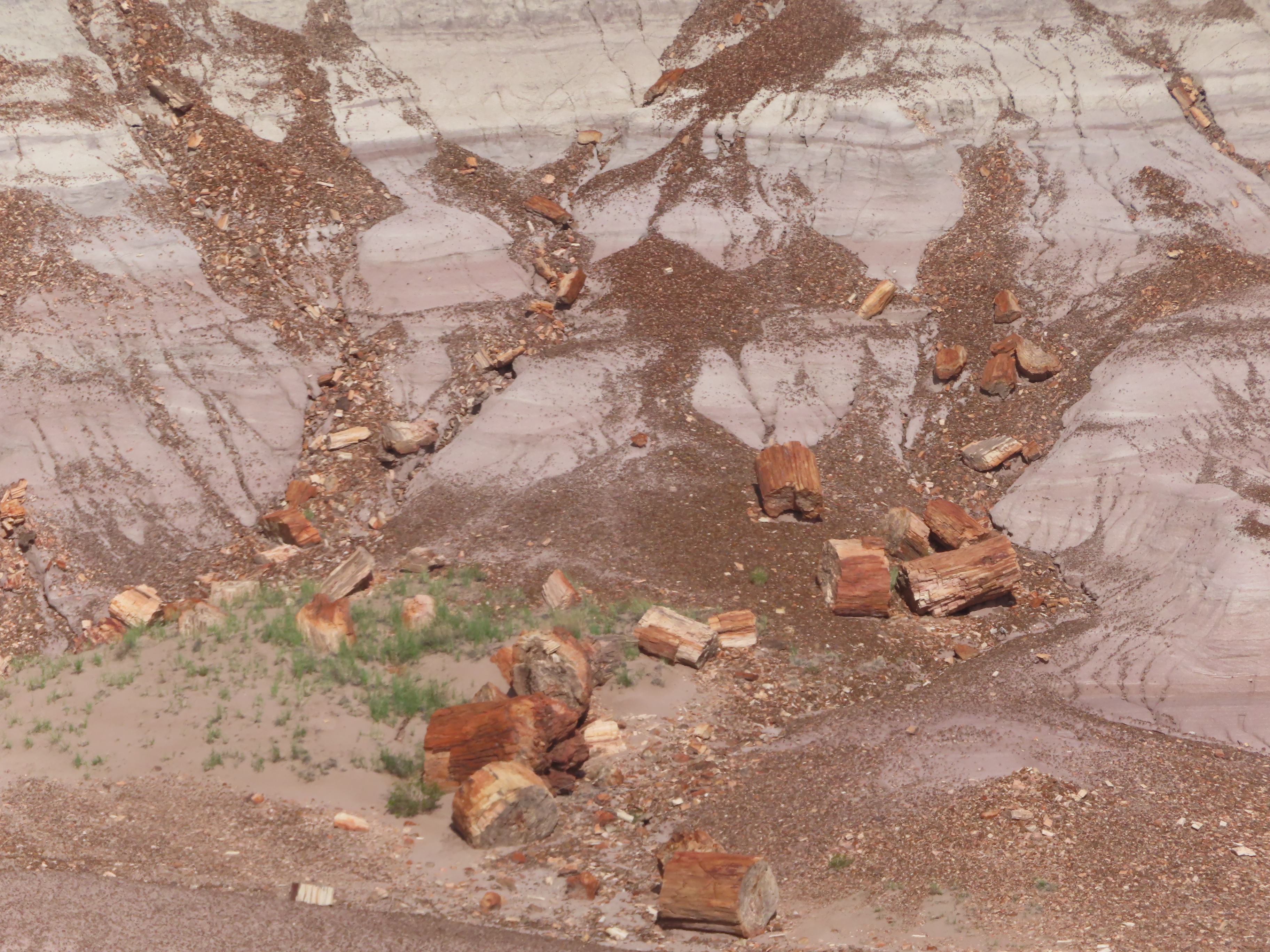

What sets Arizona's Petrified Forest apart is that it contains the largest concentration of petrified wood on earth. Petrified logs are increasingly becoming the dominant feature, and the multi-colored desert is now becoming the backdrop. The Jasper Forest – panoramic view of high concentrations of petrified wood. The Jasper Forest overlook is a great location for a sweeping view, with petrified logs as far as the eye can see.


The Crystal Forest offers many petrified logs glimmering with quartz crystals along a paved loop trail. Crystal Forest is the perfect place to see many intact petrified trees and logs that appear to have been cleanly cut with chainsaws. Appearances can be deceiving. 


Quartz crystals inside the logs produce clean fractures when pressured by forces of nature. In the morning or late afternoon puts the sun at an angle to best experience the sparkling colorful crystals.


We enjoyed d
inner at Mesa Italiana Restaurant. All our entrees were served with Fresh Mesa House Salad & Hot Garlic Bread! Yum, yum, yum! Charlie, Jim & Mary had the Lasagna with Meat, Layered in mozzarella, ricotta and parmesan. I enjoyed the Italian sausage sautéed with onions, peppers, & black olives, served in a red wine and tomato sauce. I was pleasantly surprised by the quality of the Italian food in a southwestern town. 

It was a restful evening at the campground. Another great day on our #Route66RVcaravan with #yankeeRVtours

#TwoLaneAdventures