Sunday, July 31, 2016

Day 14 of our 30-day Southwest Grand Circle Caravan – Travel Capitol Reef to Moab


We departed Thousand Lakes RV Resort and headed east on UT 24, back through Torrey Utah and a portion of Capitol Reef National Park.


On part of the drive, one of the caravaneers, keyed their mike on our FM radios and said “look over at 10 o’clock, it looks like the Badlands.” I have never been to the Badlands, but if that is what they look like, count me in! Adding it to the bucket list!


As we moved further east on UT 24 past Capitol Reef National Park, we passed through Caineville UT. I would not call it a big town, I might not even call it a town! But it is sparsely populated ranching and farming community, with several homes, a café, RV site and a Roadway Inn! History tells us that the town was originally settled along the fertile banks of the Fremont River in 1882. According to one legend, the Mormon Church sent the Ney and Behunin families to settle the untamed area; Ney left after one night but Behunin and his nine family members stayed and built the first cabin in the area. Other sources say a young Walter Hanks led the way on foot, followed by Behunin and two others who together accomplished the difficult task of taking a wagon through the rugged Capitol Reef gorge. 

By the spring of 1883, several families had joined the Behunins, and Caineville continued to grow into an agricultural community. During the winter of 1892-‘93 a diphtheria outbreak struck the community, claiming many lives. Over the years the town was also plagued by several floods. After a particularly devastating flood in 1909 many farmers and ranchers abandoned the town. Behunin’s cabin still stands, sort of, and can be seen just off Highway 24

In the middle of these rock formations is an old cement truck, looks like at one time, it was used to point the way to the café. It does look like it belongs among the rock formations, because they look more like piles of sand or dirt, than rocks. But I can guarantee you they are hard as rock!


We passed by Factory Butte, to the north of UT 24. Factory Butte is the most recognizable feature of a large area of stark, barren land either side of the Fremont River known as the Upper Blue Hills. The topography is characterized by the grey color, completely devoid of vegetation. If you did not see the sign, you would not know that it was anything special!


There was a “Giles Townsite” sign on UT 24, between Caineville and Hanksville. The historic ghost town of Giles sits precariously in the middle of the breathtakingly barren and stark Blue Valley which takes its name from the surrounding blue clay. The first settler in Blue Valley was Hyrum Burgess and his family who settled on the north side of the river in 1883. Hite Burgess is credited with surveying the first dam and three-mile irrigation canal. The dam was made of rock and brush. After a short time a flash flood washed the dam away. In June of 1895, a town site south of the Fremont River was laid out and dedicated with fifty original parcels of land, four short streets, and two long streets. A bridge was used to cross the river from the main county road into the town of Giles. At this time, the town name of Giles was chosen in honor of Henry Giles, the first Latter Day Saint Bishop. Another dam was built high enough to get the water into the ditches and, due to this success other settlers came to live in Blue Valley Giles in March of 1887. The ninety plus families of Giles in Blue Valley began to desert and move out after devastating and repeated flooding that occurred in 1909 and 1910. Jonathan Hunt was one of the last people to stay in Giles. Mr. Hunt died in Giles in 1922.

We drove along the Fremont River, which flows from the Wasatch Plateau through Capitol Reef National Park to the Muddy Creek near Hanksville. We found these interesting concrete channels in the river hear UT 24.

In Hanksville, UT 24 turns north toward I-70. Hanksville is a small town of less than 400 people. It is rich in folklore and history, thrives on tourism for travelers seeking a central location to explore Capitol Reef National Park, Goblin Valley State Park, the San Rafael Swell and Robber’s Roost. Hanksville was first settled in 1882 and called “Grave’s Valley” after a member of the Powell expeditions. The settlement, which lies at an elevation of 4300 feet, was renamed Hanksville in 1885 for Mormon pioneer leader Ebenezer Hanks. Agriculture and mining were the primary roles of the community but outlaws such as Butch Cassidy and his Wild Bunch often came to Hanksville for supplies while hiding out in the nearby canyons. Hanksville was also a main supplier for uranium prospectors in the 1940s and 50s. Hanksville’s uranium and gold booms have long since ended, but the area is still rich in dinosaur fossils which are frequently uncovered at the Hanksville-Burpee Quarry.

The Hallow Market is located at the intersection of UT 24 & UT 95. Just as its name sounds, the convenience store is located in a hallowed out rock formation. It took the owners 4 months to excavate. We made a rest stop adjacent to this gas and grocery store. One of our caravaneers had a fuel line leak. The tail-enders (the couple that brings up the rear of our convoy of RV’s) stayed behind with them, while the rest forged ahead. The Tail-enders went in search of a mechanic. Two miles down the road, they found one. He came to the location, figured out what he needed, went back to his shop and got the tools and parts needed. Came back to the RV and repaired it. The best news, was this small town mechanic, that saved the day … charged less than $100 for the entire repair!  A mechanic contracted by anyone of our extended warranty companies would have charged much more than that!

We passed by Goblin Valley State Park. The name makes me want to turn in and check it out! Its eminent feature is its thousands of hoodoos and hoodoo rocks, referred to locally as "goblins" which are formations of mushroom-shaped rock pinnacles. The distinct shapes of these rocks come from an erosion-resistant layer of rock atop softer sandstone. Along with Bryce Canyon National Park, Goblin Valley State Park is one location with some of the highest occurrences of hoodoos in the world.

We turned onto Interstate 70 East and headed to UT-191, where we exited the Interstate and headed south on 191.

We passed by the Moab Regional Airport, and it made us miss home. We saw a sky diver descending from Skydive Moab and it reminded us that we can see sky divers every day from Majestic Oaks RV Resort.


We arrived at our home for the next four nights, Archview RVResort. Over the horizon, we could see the first glimpses of Arches National Park.


It amazes me, every time we drive from place to place, how the rock formations change. Not just minor changes, but complete changes in the structure, color and overall views. The whole trip is full of unique formations, thus pictures!


I can't wait to see what Moab and Arches National Park has in store for us, as our Adventure Continues with Yankee RV Tours!

Day 13 of our 30-day Southwest Grand Circle Caravan – Capitol Reef National Park

We spent a day touring the Capitol Reef National Park. Capitol Reef’s defining geologic feature is a “wrinkle or buckle” in the Earth’s crust. It extends over 100 miles, from Thousand Lake Mountain to Lake Powell. This “wrinkle or buckle” is a Waterpocket Fold. Along The Fold, rocks have been pushed upward and erosion has cut through the layers, creating deep narrow canyons and interesting formations.


In 1937, President Roosevelt set aside 37,711 acres of the Capitol Reef area as a National Monument. Two bills were introduced into Congress in 1970 to determine if Capitol Reef should become a national park. The Department of Interior officials recommended that 254,000 acres be set aside as a national park. A year later, the legislation was signed by President Nixon in December 1971.


It was an eleven mile drive into the park from our campground. The drive into the park was just as beautiful as what we have seen already on our adventure!


The first recognizable formation we found was “Chimney Rock.” It is a 325 foot partially eroded pillar of red sandstone. We headed out early in the morning, so the light was in the wrong spot to get perfect pictures. We tried again on our return trip, light was not much better! Did you know that "Chimney Rock" is a popular name ... there are 15 rock formations with this name in the Untied States and Canada. Wow, maybe we need to add seeing all of them to our bucket list!


We drove up to Panorama Point. A foot path from the Panorama Overlook guided us along the canyon edge where views look down upon layer after layer of various sandstone formations. Here, the diverse geology of Capitol Reef National Park is quite evident with layers of reds, tans, browns and whites with trees and shrubs dotting the landscapes.


A short drive, on a gravel road, beyond Panorama Point, is Goosenecks Overlook. From the parking area, a foot path (of sorts) climbs a ridge where the path descends to the canyon rim. Carefully pick your way along the rock strewn trail, because there are few barriers between you and the 800 foot drop to Sulphur Creek below. From this view, the gooseneck displays strong evidence of the powerful forces of relentless river currents. 


Rick discovered a unique box canyon here. Our friend, Charlie, said he could imagine the settlers getting trapped in the box canyon by the Native Americans! We could have gotten closer to the edge of this box Canyon, but I am a big chicken!


We stopped at the Visitor Center and watched the movie on Capitol Reef. This was the most unique theater, we have seen thus far. It was bench seating with the screen lower than the seats and a picture window above the screen. When the movie was ready to start, the curtains closed automatically darkening the room.


The Gifford farm lies in the heart of the Fruita valley. It is a green valley among the cliffs of the Waterpocket Fold, offering fruit in season. The Gifford farmhouse represents the early Mormon settlement of the Fruita valley. The house depicts the typical basic nature of rural Utah farm homes of the early 1900s. It was inhabited by a few families who were about equally good Mormons, frontiersmen and farmers. Water was carried to the house from the Fremont River and was used untreated. 
A two-hole outhouse served the family until an indoor bathroom and plumbing was installed in later years. The homestead includes a barn and coral. Gifford added a kitchen in 1946 and the bathroom, utility room, and carport in 1954. The house received electricity in 1948. The Gifford family occupied the home for 41 years, until 1969 and were the last residents of Fruita. Dewey Gifford sold his home and land to the National Park Service in 1969. With the Giffords' departure, the story of Fruita as a farming community came to a close.

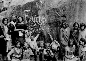
The Fruita Schoolhouse was were the Gifford children and all the children in the Fruita Valley attended grade school. Classes had been conducted for two years before the Fruita Schoolhouse was built, in 1896. Even though only eight families lived in Junction, these farmers had large families. One raised thirteen children themselves, one of which, became the first schoolteacher at age twelve. Nettie's first class had 22 students, three of whom were her siblings.

Originally, there was a flat, dirt covered roof on the school. A peaked, shingled roof was added in 1912. The interior walls, originally bare and chinked logs, were plastered in 1935. The first desks were homemade, constructed of pine, and seated two students each. These were sometimes used to quiet unruly students. The teacher would seat a troublesome boy with a girl, and the resulting blow to his ego would often bring him under control.


Behind the school, we found the boulder with FRUITA GRADE SCHOOL carved into it. Here is a picture from 1935, of the same rock. That is amazing!
photo courtesy of : NPS.gov


The Fruita Orchards are still active in growing many varieties of fruit. In season you can eat all the fruit you want while in the orchard, but any you want to take out of the orchard you must pay for. The Mule Deer are common residents in the Fruita orchard area. We were lucky enough to see one enjoying all the fruit he could, while he was in the orchard! What a perfect picture of this majestic beast!


Down a little ways past the Fruit Schoolhouse, you can see the Petroglyph Panel on Utah 24. What is a Petroglyph? It is pictures that are carved or pecked into the rock, they depict people, animals and other shapes and forms. Human-like figures usually have trapezoidal shaped bodies with arms, legs and fingers. The figures are often elaborately decorated with headdresses, ear bobs, necklaces, clothing items and facial expressions. 


Abstract designs, geometric shapes and hand prints are also common. Most are attributed to the Fremont Culture, which existed in areas of Utah from approximately AD 600 to 1300. The Fremont people were contemporaries of the Ancestral Puebloans(Anasazi) of the Four Corners area. 


The meaning of rock art is unknown. Artists may have recorded religious or mythological events, migrations, hunting trips, travel routes, and other important knowledge. Look closely at all the pictures to see the details.


Several more rock formations in the park have signs and names. Including Twin Rocks, which is just as you would expect. Two rock formations that look exactly the same.

The Egyptian Castle also is another formation that fits its name. It sits on top of a high rock formation with tall spires all around it and provides you with a mystical feels of a castle.


The scenic drive is composed of ten stops. Not all stops have monuments that depict anything, so of the stops help you better understand the rock formations.

Stop 1 - Most rock at Capitol Reef is sedimentary, formed in layers from loose materials, like mud and sand. Geologists classify the rock layers into various formations. Many formations also have different parts, or members. These layers record the landscapes and lifeforms of a younger planet Earth. Thin beds of reddish-brown shale were formed from silt and clay that came to rest in the quiet waters of lagoons, mud flats, and coastal flood plains. These layers are called the Moenkopi layer. The banded gray and burgundy layers above the Moenkopi contain volcanic ash, is names as the ChinleFormation.

Stop 2 - The rugged western escarpment of Capitol Reef tells the essentials of a complex story. Rock bands of differing thickness, colors, and textures lay one upon another like layers of a cake. The rocks of Capitol Reef were once sediments laid down in many different environments during the past. Younger rocks lie on top of older rocks.


Stop 3 - The twisting Grand Wash spur road takes you into a landscape dramatically different from the dark red hills along the base of Capitol Reef. Grand Wash is a narrow, steep-walled canyon subject to dangerous flash floods that often arrive with little warning. We started to turn down it, but we are in a PT Cruiser, we will skip this turn-off!


Stop 4 - The massive, sheer cliffs of Wingate Sandstone have far-reaching lines that intercept one another at all angles in the rock. Large scale crossbedding indicates windswept drifted dunes of an ancient desert. Small cracks are widened by frost and plant roots. Shallow holes in the cliff are excavated as water erosion removes more weakly cemented sand grains, leaving solution pockets and natural bridges.

Stop 5 - Vegetation is more abundant in Grand Wash. Although relatively bare stone, or slickrock, dominates the landscape here, plants also are plainly visible. Flash floods can roar down canyons, carrying debris that crushes and smothers vegetation. Plant life survival requires fulfilling the need for adequate water and protection from floods.


Stop 6 - The road now winds through an older, deeper part of the Moenkopi formation. Uniform layers of sandstone can be seen among the red shale beds, often forming small ledges. The surfaces of many slabs are covered with ripple marks or mud cracks that formed when pools of water dried under a hot sun. This formation was laid down by the gently moving waters of coastal tidal flats.


Stop 7 - Slickrock Divide separates two large drainages. On either side of this divide, streambeds channel rain runoff and debris into Grand Wash to the north, and Capitol Gorge to the south. When rain does come to Capitol Reef, it often descends in torrents. Large expanses of bare rock and thin patches of soil can do little to absorb and hold it. However, rushing water shapes this landscape by carrying away material already loosened by weathering. Gravity draws loosened debris to washes where it is picked up by moving water. Imagine all the torrents of a plateau converging upon a single gorge and you will realize how floods develop in a "flash".

Stop 8 - The yellowish-gray Shinarump is a very distinct member found 
intermittently at the base of the Chinle Formation. Shinarump sediments were laid down in the channels of rivers that meandered across a coastal plain. Because rivers meander instead of blanketing an area, the Shinaump is visible only sporadically. Shinarump also contains uranium ore. The old mine tunnels at the mouth of Grand Wash penetrate the Shinarump. The Oyler Mine used to mine secondary Uranium minerals. 

Stop 9 - The Capitol Gorge spur road is longer and more winding than Grand Wash. Although a through road from 1884 to 1962, the drive now ends in a few miles. These narrows twist through Wingate Sandstone, the formation that forms the sheer cliffs along the west face of Capitol Reef and the towering walls of Grand Wash. Capitol Gorge provides dramatic evidence of the forces of erosion at Capitol Reef National Park.

Stop 10 - The Navajo Formation, over 1,400 feet thick in places, caps the upper reaches of Capitol Gorge. Its white, rounded domes, reminiscent of the nation’s capital building, inspired part of the name for Capitol Reef. Prospectors with seafaring experience viewed this monocline as a barrier to transportation, and supplied the nautical term "reef".


Capitol Reef was an awesome place to visit. I is hard to believe that it was yet again, different than any of the other parks we have visited so far!

Friday, July 29, 2016

Day 12 of our 30-day Southwest Grand Circle Caravan – Travel from Bryce to Capitol Reef

We departed Ruby’s Inn RV & Campground at 9 am, just like Florida seniors everyone was ready well before 9 am! We headed north on Highway 63, aka Main Street. Then, we turned east onto Scenic Byway 12, Utah's All-American Road.

It is simply one of America's most beautiful drives. We passed through twisting canyons, by red rock towers, through pine forests, into pioneer towns and traversed over twisting switchbacks, we experienced one of this nation's most beautiful drives.


The first town we came to was Tropic. Tropic’s unusual name originated with the claim made by the town’s first settlers that the climate here was much more “tropic” than that in nearby settlements. No palm trees, but it is warmer than Bryce Canyon! On the far end of town, where beautiful sandstone cliffs turning into hoodooos!


PIC 19 - The next pioneer town we came to was Henrieville, it seems like it has been untouched by time. Originally settled in the 1870’s, the old town school, constructed in 1881 of rough-cut timber harvested on a nearby mountain, is still in use today.

The towns along this scenic route all have unique town signs. Some are carved in stone, others are punched-out metal. Check out Tropic, Henrieville and Escalante signs. There is no simple green metal sign for these towns!

We skirted the edge of the Kodachrome Basin State Park. Kodachrome Basin was named during the 1940’s in honor of Kodak film (which is from my hometown, Rochester NY.) The film provided exceptional color accuracy of the colors in this park. The park has more than 60 sand pipes, ranging in height from 6 to 160 feet tall.

After the Kodachrome Basin SP, we started climbing and climbing and climbing. I have been trying to get a good picture of our “convoy.” Climbing these hills gave me this opportunity.

I caught a picture of a little bit of pink limestone. Turns out this is Powell Point, names after John Wesley Powell who led the expedition in the late 1800’s. These cliffs climb to a height of almost 10,200 feet.


Just before Escalante, there were some unique features in the sandstone cliffs on the south side of scenic highway 12. The Arch attracted my attention. But according to Pueblo history, there is a stone and mud daubed structure near there that was thought to be a storage building for grain.


 Escalante is one of the larger towns we will pass through on this route. It is often called the “Heart of the Scenic Byway 12” because it is between the elevated meadows of the Aquarius and Kaiparowits Plateaus and the low desert country surrounding the Escalante Canyons in the middle of the byway.


We followed a long slow decent into the low desert country via a series of switchbacks through a solid rock canyon. We got to see some more checkerboard rock and other picturesque colors.


We were very close to some of these rock formations as we started up the other side, out of the rock canyon.

Between the breathtaking engineering of the ridge-traversing ride on “The Hogsback”, just before the dirt road named "Hell’s Back Bone" and some of world's most astounding geography, I could not stop taking pictures! The Hogsback, is an internationally famous stretch of the byway. Why is it famous you ask? Because the asphalt sits on a thin strip razorback ridge of slickrock and the sides drop off to steep terrain. Our drive was slow and deliberate, but the views were amazing! Of course, what goes up, must come down, after the Hogsback, we started back down.

Outside of Boulder, we started our next climb by winding along the east side of Boulder Mountain, climbing to an altitude of more than 9,000 feet. Close to the road are groves of aspen, pines, spruce and fir trees.

Near the top of our climb, looking to the south, we could see the sparkling blue waters of Bown’s Reservoir. You can camp close to the reservoir and enjoy the hiking trails.

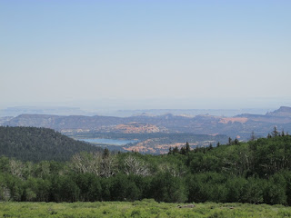
You can also see the five peaks of the Henry Mountains and the pink cliff of the Waterpocket Fold in the foreground.


Also close to the road are elks and cows, yes cows! This is also an open range and cows are free to roam. There are cattle crossings on the road, to stop them from leaving the open range.


After we crossed the cattle crossing, just a little further in our climb, we actually saw cows on the side of the road. One was trotting in our direction, then there were two that were standing side by side just looking at us!


 It is amazing the different landscapes that we have seen on this ride!


It is amazing the different landscapes that we have seen on this ride!

It is amazing the different landscapes that we have seen on this ride!

It is amazing the different landscapes that we have seen on this ride!

While driving Highway 12, imagine climbing the 124 miles on a bike. Elite cyclists do just that as part of America's Toughest Stage Race, the Tour of Utah, which begins next week.


Arrived in Torrey Utah, we are staying at the Thousand Lakes Campground for the next two days. With glorious views at the rear of the campground, I can’t imagine how beautiful the views at Capitol Reef will be!