We departed Ruby’s Inn RV & Campground at 9 am, just
like Florida seniors everyone was ready well before 9 am! We headed north on
Highway 63, aka Main Street. Then, we turned east onto Scenic Byway 12, Utah's
All-American Road.
It is simply one of America's most beautiful drives. We passed
through twisting canyons, by red rock towers, through pine forests, into pioneer
towns and traversed over twisting switchbacks, we experienced one of this nation's
most beautiful drives.
The first town we came to was Tropic. Tropic’s unusual name
originated with the claim made by the town’s first settlers that the climate
here was much more “tropic” than that in nearby settlements. No palm trees, but it is warmer than Bryce Canyon! On the far end of town, where beautiful sandstone cliffs turning into hoodooos!
PIC 19 - The next pioneer town we came to was Henrieville, it seems
like it has been untouched by time. Originally settled in the 1870’s, the old
town school, constructed in 1881 of rough-cut timber harvested on a nearby
mountain, is still in use today.
 The towns along this scenic route all have unique town
signs. Some are carved in stone, others are punched-out metal. Check out
Tropic, Henrieville and Escalante signs. There is no simple green metal sign for
these towns!
We skirted the edge of the Kodachrome Basin State Park.
Kodachrome Basin was named during the 1940’s in honor of Kodak film (which is
from my hometown, Rochester NY.) The film provided exceptional color accuracy
of the colors in this park. The park has more than 60 sand pipes, ranging in
height from 6 to 160 feet tall.
After the Kodachrome Basin SP, we started climbing and
climbing and climbing. I have been trying to get a good picture of our “convoy.”
Climbing these hills gave me this opportunity.
I caught a picture of a little bit of pink
limestone. Turns out this is Powell Point, names after John Wesley Powell who
led the expedition in the late 1800’s. These cliffs climb to a height of almost
10,200 feet.
Just before Escalante, there were some unique
features in the sandstone cliffs on the south side of scenic highway 12. The
Arch attracted my attention. But according to Pueblo history, there is a stone
and mud daubed structure near there that was thought to be a storage building
for grain.
We followed a long slow decent into the low desert
country via a series of switchbacks through a solid rock canyon. We got to see
some more checkerboard rock and other picturesque colors.
We were very close to some of these rock
formations as we started up the other side, out of the rock canyon.
Between the breathtaking engineering of the
ridge-traversing ride on “The Hogsback”, just before the dirt road named "Hell’s
Back Bone" and some of world's most astounding geography, I could not stop
taking pictures! The Hogsback, is an internationally famous stretch of the byway.
Why is it famous you ask? Because the asphalt sits on a thin strip razorback ridge
of slickrock and the sides drop off to steep terrain. Our drive was slow and
deliberate, but the views were amazing! Of course, what goes up, must come
down, after the Hogsback, we started back down.
Outside of Boulder, we started our next climb by
winding along the east side of Boulder Mountain, climbing to an altitude of
more than 9,000 feet. Close to the road are groves of aspen, pines, spruce and
fir trees.
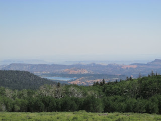
Near the top of our climb, looking to the south,
we could see the sparkling blue waters of Bown’s Reservoir. You can camp close
to the reservoir and enjoy the hiking trails.
You can also see the five peaks of the Henry
Mountains and the pink cliff of the Waterpocket Fold in the foreground.
Also close to the road are elks and cows, yes
cows! This is also an open range and cows are free to roam. There are cattle
crossings on the road, to stop them from leaving the open range.
After we crossed the cattle crossing, just a little
further in our climb, we actually saw cows on the side of the road. One was
trotting in our direction, then there were two that were standing side by side
just looking at us!
It is amazing the different landscapes that we have seen on this ride!
It is amazing the different landscapes that we have seen on this ride!
It is amazing the different landscapes that we have seen on this ride!
It is amazing the different landscapes that we have seen on
this ride!
While driving Highway 12, imagine climbing the 124 miles on
a bike. Elite cyclists do just that as part of America's Toughest Stage Race,
the Tour of Utah, which begins next week.
Arrived in Torrey Utah, we are staying at the Thousand Lakes
Campground for the next two days. With glorious views at the rear of the
campground, I can’t imagine how beautiful the views at Capitol Reef will be!


No comments:
Post a Comment