
Hence, the name Worlds End State Forest Park. During 1936, a letter campaign caused the park name to be changed to Whirls End. Another letter campaign forced the matter to be brought to the former State Geographic Board, who supervised the official naming of places. The name was changed back to Worlds End during 1943.


The scenery is spectacular, especially the June mountain laurel. Instead of hiking, we drove to the Canyon Vista. It’s a spectacular view of the Loyalsock Creek gorge from here at an elevation of 1750 feet. Many wildflowers grow beneath the canopy of maturing ash, sugar maple, and black cherry trees.


The extensive forest cover, hemlock valleys, and mountainous terrain provide ideal habitat for “big woods” wildlife. White-tailed deer, black bear, and wild turkey are regularly sighted. The patient observer may find bobcat, coyote, and river otter.
More than 200 species of birds have been recorded. We only saw chipmunks, blue jays, a cardinal and chickadees.
We drove to Eagles Mere, which is a small community in the endless mountains region of northeastern Pennsylvania. There are 120 full time residents, but during the summer that number swells to over 3,000. Beginning around 1870, Eagles Mere evolved as the "East Hampton" of Philadelphia, morphing into a famous mountain resort, to become the summer playground for vacationers escaping the heat in such cities as Philadelphia, Baltimore and Harrisburg.
A number of large hotels surrounded the lake and provided seasonal retreats for thousands of visitors each year as did turn-of-the-century Victorian cottages. The town remains on the National Register of Historic Places. While the Inn is an original structure from the earliest time in Eagles Mere, many of the charming - and sometimes rambling - "cottages" remain as reminders of a refined past, sometimes referred to as, "The Town that Time Forgot."

To get access to a cell signal or wi-fi we had to venture 10 miles to Laporte. It is a borough in Sullivan County, Pennsylvania. The population is under 600, yet despite its small size, it is the county seat of Sullivan County. It is the smallest county seat in Pennsylvania by population and in 1969 was one of the two smallest in the US. It was a mountain resort, formerly a lumbering and tannery center, founded in 1847 and named for John Laporte, Surveyor General of Pennsylvania. Wide verandas front many of the houses. Among the deeds preserved in the courthouse here is one recorded in 1864, which transfers the ownership of a large tract of land on a mountain plateau four miles west of Laporte to 'Almighty God.' The plateau was once the site of the Celestia Community of Adventists, founded in 1853 by Peter Armstrong and his wife. A small group of Adventists, interested in Armstrong's plan for communalism in preparation for the expected coming of the Lord, maintained the experiment for several years. Forced by hardships and the dissatisfactions of other members to abandon it, Armstrong returned to Philadelphia, after deeding the property to the Lord. Eventually the land was taken over by the county for unpaid taxes. The Sullivan County Courthouse was added to the National Register of Historic Places in 1978.
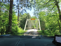
I found the “Bridge on Rock Run” in my online surfing, before we got here. So, naturally, we had to find it. Turns out, it was a gravel and dirt road … that has been happening a great deal in PA! The bridge carries one lane of an unimproved road in a forested setting in the Wyoming State Forest. This bridge is a very rare surviving example of a bridge by the Horseheads Bridge Company. This simple design decision gives the bridge an attractive and unique appearance that immediately identifies the bridge as a product of its builder. The one span, 125' long, Pratt thru truss bridge was fabricated in 1897. It is supported on a concrete and stone. The bridge is historically and technologically significant based on its completeness, documentation, and distinctive detailing.
Rock Run Road is a popular hiking area with amazing natural beauty in the Loyalsock State Forest. Near the mid-point of the Road, you can head to Sones Pond, a tributary of the Little Loyalsock Creek. The hillside is filled with an assortment of waterfalls, cascades, grottos, and pools. Some of the falls are seasonal. None of the falls are over 10 feet tall, but it is a stream of remarkable beauty. Old grades on the east side of the stream help with access. There are about 6-7 falls or cascades of varying heights.
Tamarack Run Natural Area is a unique natural area located in the northeast portion of the Loyalsock State Forest and is comprised of two hundred and thirty-four acres near Sones Pond. Named for the tamarack tree, this boreal conifer wetland provides protection for the plants, amphibians, and reptiles that call this natural area home.
Check back tomorrow, to see where our #TwoLaneAdventures
take us!


No comments:
Post a Comment