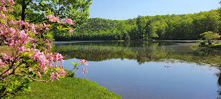
We
are camping at the Sherando Lake Recreation Area Family Camping, part of the
George Washington National Forest. It is a beautiful park with tons of walking
trails and two lakes. I enjoyed my first morning walk here and captured this
beautiful photo.


On
our way to Skyline Drive and The Blue Ridge Parkway, we passed under and overpass
and found vividly painted bridge supports on Route 250.
Shenandoah
National Park, established in 1935 before skyscrapers and air travel were
common. The park was designed to give millions the opportunity to travel to the
top. Its 197,000 acres of beauty with 500 miles of trails, scenic overlooks,
concessions and picnic areas. From the beginning, national park planners,
capitalizing on the new popularity of motor cars, called for Shenandoah’s
“greatest single feature” to be a sky-line drive on which motorists could enjoy
a leisurely drive through the Blue Ridge and experience the awe and inspiration
of magnificent views. Construction of Skyline Drive had begun even before
Congress established the National Park. Formed from
over 1,000 privately owned tracts of land, Shenandoah started as patchwork of
forests, fields, orchards and home sites. In 1976 Congress designed over 40
percent of the park as wilderness, providing the highest level of protection to
this precious resource.We entered
the park and drove on Skyline Drive first. Virginia's Skyline Drive is a
National Scenic Byway that runs 105 miles along the crest of the Blue Ridge
Mountains from Waynesboro to Front Royal. Skyline Drive is Shenandoah National
Park’s linear conduit, with 75 overlooks connecting travelers to all the major
visitor centers, campgrounds, lodges, picnic areas and most trailheads.
Concrete posts numbered every mile keep you apprised of your whereabouts. We
aren’t driving 105 miles today!

What
separates Skyline Drive and the Blue Ridge Parkway? The answer to that question
is Rockfish Gap, aka crest of the Blue Ridge. Rockfish Gap is a wind gap
located in the Blue Ridge Mountains between Charlottesville and Waynesboro. Rockfish
Gap has always had that name, acquiring it from the river which rises in part
from its base.
The Blue
Ridge Parkway was decades in the making by many people. Its route, stopping
points and vistas were all carefully planned. Stanley Abbott, the chief parkway
designer and first superintendent, often talked to area residents and ensured
their stories became part of the parkway. As you travel on this historic road
enjoy the careful designs revealing the region’s people, landscapes and
exceptional views! Be sure to stop often at historic sites, view exhibits and
walk the trails.
We
stopped at the Afton Overlook. The community of Afton can be seen from this
overlook. Notable because it was the route Thomas Jefferson took in 1818 on his
way to confirm plans for the University of Virginia. Afton was once a prized
destination for tourists seeking to escape the crowded cities and enjoy the
natural beauty of the Blue Ridge Mountains.
Afton
is now the site of the western trailhead of the Blue Ridge Tunnel, a former
railroad tunnel converted into a pedestrian trail. Hiking through the tunnel is
a truly unique hiking experience!
We
stopped at Humpback Rocks Visitor Center for the facilities. I snapped this
picture of the beautiful azaleas in bloom.
We
enjoyed lunch at Benny Stivale’s in downtown Waynesboro. Google told me it was similar
to ABC Pizza. Well, it was nothing like ABC, except the fact that they both
serve pizza! This place served slices of pizza, HUGE slices of pizza!
Charlie wanted to wash the car, so we stopped at Pinky’s Car Wash for a quick
wash! Then it was off to Kroeger’s for a few groceries and Truist for the ATM.
We headed back to our temporary home in the George Washington Nat’l Forest
I
finished the day with a walk to the upper Sherando Lake, it is much smaller
than Sherando Lake, but just as beautiful!
Stay tuned
for more fun on our Two Lane Adventures!


No comments:
Post a Comment