Wednesday, October 17, 2018

Day 112 of 117 on our “Go West, Young Man” Two Lane Adventure – Tuesday 10/16/18


We departed the Starkville KOA in Mississippi, of course it was another rainy dreary and overcast morning. We waited a bit too long to unhook the utilities, because the rain started to come down harder. Oh, well … a little rain never hurt anyone!

The campground is located on the sandy shores of Oktibbeha County Lake, it is a 513-acres. It is the largest state fishing lake in North Region, was first opened in 1967. It is one of the 19 state fishing lakes operated by the Mississippi Department of Wildlife, Fisheries and Parks.

Columbus, Mississippi, is a noteworthy heritage destination on the Tennessee-Tombigbee Waterway. With three National Register Districts, the city boasts nearly 700 nationally significant properties and one of the largest collections of 19th century homes in Mississippi. It is also noted as the birthplace of renowned playwright Tennessee Williams. The modern city traces its history to 1810, when Choctaw interpreter John Pitchlynn established a home four miles from what is now Columbus. Pitchlynn's farm on Plymouth Bluff was fortified during the Creek War of 1813-1814 and became an important strong point on the Choctaw frontier.

Columbus Air Force Base's history began 26 June 1941, when the War Department approved establishment of an Army Air Field for the Columbus area. Behind this approval were months of concerted efforts by the local citizens. The citizens' efforts bore fruit. Six months before Pearl Harbor the War Department announced that a pilot training base would be established in Columbus. The base began as a training facility for fighters and bombers. No one designated or suggested a name for the new base until 22 January 1942. On that date, the War Department announced the installation would be named Kaye Field, in honor of Captain Sam Kaye, a World War I flying ace from Columbus. That designation went into effect on 24 February. However, the name issue soon became one of confusion because another nearby base of Key Field, Meridian, Mississippi, had a similar sounding name. To correct the problem, in March 1942, the War Department changed the name of the base from Kaye Field to Columbus Army Flying School.

We crossed from Mississippi into Alabama with a little bit more sunshine and a few less clouds. In 2003, forty-one years after Lynyrd Skynrd recorded "Sweet Home Alabama," the state began adding the slogan for signs welcoming visitors at the state lines. Alabama had previously used the song title on state license plates and in tourism promotions. The song is recognized all over the world and the phrase "Sweet Home Alabama" makes people happy.

Present-day Gordo Alabama sits on land that was part of some of the earliest US land grants in the area, issued around 1821. Tradition has it that a soldier returning from the Battle of Sierra Gordo during the Mexican Revolution dubbed the area Gordo. A sawmill opened in the area in 1831 and a post office was established in 1847. During the Civil War, men in Gordo formed a company that was attached to the 19th Alabama Regiment. The railroad came through in the late 1890s, and the town was relocated to be closer to the rail line. The first school was built in 1898. Gordo incorporated in 1900, with initial municipal elections being held the following year. By 1905, Gordo had grown enough to support six businesses; by 1913, that number had increased to around 30. A new brick schoolhouse was built in 1911, and by 1913, the town had a telephone system, a bank, a bottling works, and two cotton gins. An elementary school was built in 1936.

The City of Tuscaloosa is one day older than the State of Alabama. In 1831, the University of Alabama was established. Establishment of the Bryce State Hospital for the Insane in Tuscaloosa in the 1850's helped restore the City's fortunes. During the Civil War, Tuscaloosa County furnished about 3,500 men to the Confederate armies. During the last weeks of the War, a Federal raiding party burned the campus of the University. Tuscaloosa shared fully in the South's economic sufferings which followed the defeat. By the advent of the 20th Century, the growth of the University of Alabama and a strong national economy fueled a steady growth in Tuscaloosa which continued unabated for 100 years. University of Alabama says “Roll Tide” … their shuttle busses are called “Crimson Ride.” It’s a cute play on their motto and their color!

We passed the Tallledega Forest, to the south of our route. The Talladega National Forest offers a peaceful atmosphere that is filled in wild game, camping, and hiking utopias. The forest also features picturesque scenic waterfalls throughout its striking setting. The total Forest covers almost 400,000-acres. Before it was bought by the federal government in the 1930s, the area that comprises the Talladega was extensively logged and represented some of the most abused, eroded wastelands in all of Alabama. Pine forest regrowth now hosts a diverse eco-system.

There are few cities that have affected the flow of American history as much as the state capital city of Montgomery, Alabama. Men and women who dramatically impacted the course of our nation did so within view of the capitol steps. It was here that Jefferson Davis took the oath of office as President of the Confederate States of America. The capitol building in Montgomery was the first capitol of the Confederacy and the orders to open fire on Fort Sumter and inaugurate the Civil War were sent by telegraph from a building just down the hill. Were the view not blocked by buildings, you would also be able to see the bus stop where Rosa Parks refused to give up her seat in 1955, sparking a movement that shook the nation. 

The Montgomery Bus Boycott was organized within sight of the capitol at the Dexter Avenue King Memorial Baptist Church, then served by a young minister named Martin Luther King, Jr. In 1965, one of the most powerful marches of the Civil Rights movement came up Dexter Avenue to the capitol. The marchers had come from Selma, joined by others along the way, to demand their right to vote from Governor George C. Wallace, then known for his "segregation today, segregation tomorrow, segregation forever!" declaration. The march on Montgomery is now commemorated by the Selma to Montgomery National Historic Trail, a national park area. The trail incorporates U.S. Highway 80 from Selma to Montgomery and introduces visitors to the significance of the march and its impact on American culture.

We called ahead and I spoke to Karen, to be sure they had a site for us. She said, we would be greeted by her husband, Rick, when we arrived. Eufaula Lake Campground was just off Route 82, which is perfect for us! It is a 46 acre family owned campground, Karen and Rick purchased it in the spring of 2014. They believe that is offers a place where everyone can relax and enjoy the outdoors. It is a mix of modern amenities and rustic charm. It offers their own nature trail, but the cities rails to trails is just outside the campground and you can take it all the way into downtown.

Day 111 of 117 on our “Go West, Young Man” Two Lane Adventure – Monday 10/15/18


We departed the Texarkana KOA on US 93 south, working our way back onto US 82 East. It is another dreary rainy morning to travel.

Texas High School had the biggest American and Texas flags I have ever seen at a High School. At Texas High School, students are academically enriched through a wide array of more than 425 course offerings presenting a broad range of choices to meet the interests and abilities of students. Featuring The Ross Perot STEM Academy, students focus on science, technology, engineering and math course content that is integrated within all core subject areas. The curriculum is innovative and college-focused with instruction on inquiry, problem-solving, decision making, discovery and project-based learning.

We crossed into Arkansas by crossing State Line Ave. State Line Ave is what separates Texas and Arkansas. As we crossed State Line Avenue, there was a War Memorial in the center median. Five flagpoles fly the United States flag, the POW/MIA flag, the Arkansas flag, the Louisiana flag, the Oklahoma flag, and the Texas flag. In early 1983, some of our city's leaders in Texarkana came up with the idea to honor veterans from the Korean and Vietnam Wars from the Four States Area immediately surrounding Texarkana. Because of different reasons, they floundered with this idea for almost four years, before letting it die a slow death. In April 1987, Vietnam Veterans of America chapter #278, approached these leaders and asked if they could take over where they had left off. After several months of largely unsuccessful fundraising events, they decided we needed to show the area they meant to build this memorial. Way short of the fundraising goal, they held the groundbreaking ceremony on July 25, 1988. It worked - funds and material donations started coming in. A local government contractor set the ball in motion with a donation of $5,000. After several months of hot, hard work, shedding blood, sweat, and tears, it came together. Even though they said it could not be done, on November 12, 1988, they dedicated the Korean/Vietnam Memorial in Texarkana.

Magnolia is home to Southern Arkansas University Campus. Southern Arkansas University is a public university. It was founded in 1909 as the Third District Agricultural School (TDAS). The school was later elevated to a junior college, Magnolia A&M, in 1925, and a four-year college, Southern State College, in 1951. Renamed Southern Arkansas University in 1976, the University has grown to host over 4,000 students, serving as an educational cornerstone of the Magnolia community and Southwest Arkansas.

The Farmers Bank and Trust Reception Center and the Story Arena are unique components of Southern Arkansas University. The Story Arena is a multipurpose, covered arena located on US 82, west of the Mulerider Stables. The facility is a 78,000 square foot covered rodeo-style arena with a dirt floor and seating for approximately 1,400. The Farmers Bank and Trust is the 7,500 square foot reception area that sits in front of the arena.

There was a huuuuuge Tuscan Style Mansion outside of Magnolia on US 82. I could not find out anything about the home or the owner, but it was an awesome looking home! Too big for us … you have to clean all those rooms!

The welcome sign for El Dorado, claims it is Arkansas original Boomtown. El Dorado is Spanish for the gilded one. Matthew F. Rainey became the first resident of El Dorado by accident. Rainey’s wagon broke down there in 1843, and being unable to get replacement parts, he held a sale of his possessions. The sale went so well that he bought more goods and opened a store. It is not known if Rainey was responsible for naming his new home in recognition of his good fortune.

We don’t know her story either …. But, we saw this lady walking her mule along the side of US 82 on the edge of El Dorado, Arkansas.

The town of Crossett was named after Edward S. Crossett, a leading entrepreneur in the lumber industry's emergence in Arkansas. In May 1899, Crossett joined with three partners to form the Crossett Lumber Company, which then sought to build a lumber mill in the town of Hamburg. Displeased with the reception the proposed mill was receiving there, the company selected a site in the forest about 12 miles southeast of Hamburg, where Crossett was born as a tent city constructing the company's mill. Lumber from initial milling operations was used to build a permanent mill, company offices and employee housing. Crossett remained a classic "mill town" into the mid-1940s with Crossett Lumber owning all the town's homes and businesses until 1946. Though some early lumber towns were abandoned when the supply of harvestable trees was exhausted, Crossett's future was secured through improved forest management practices and through the manufacture of diverse forest-related products, including wood alcohol, turpentine, chemicals needed by soap and paint manufacturers, charcoal, food board and flakeboard.

Ouachita River comes from the Ouachita Mountains of west-central Arkansas. It flows in a generally southeasterly direction to join the Red River in Louisiana after flowing for over 600 miles. The Ouachita has been a navigation route since the late 18th century. Six locks and dams were built on the river prior to 1924. There are three multipurpose dams (hydropower, flood control, recreational facilities) on the upper Ouachita within the Ouachita Mountains: Blakely Mountain and Carpenter dams near Hot Springs National Park, impounding Lakes Ouachita and Hamilton, and Remmel Dam, impounding Lake Catherine.

In 2011, Hamburg was designated a Preserve America Community. The town was created in 1849. Two of the first public buildings were built the next year, the courthouse and the county jail. During the Civil War, the town provided troops to the Confederacy and several companies of the Third Arkansas Infantry that fought with the Army of Northern Virginia, commanded by Hamburg lawyer Van H. Manning. The town escaped military action during the war, though Union troops briefly occupied it during Reconstruction. The city’s economy was divided among agriculture and forestry due to the town’s geographic location. Immediately east and west are prairie regions dedicated to rice and soybean culture. 

A few miles east, cotton reigns in the Mississippi Delta. On the north and the south, timber is plentiful. Through the early 1900s, agriculture dominated though lumber production became important in later years. After the Depression, social shifts occurred when farmers gave up attempts to live off their land. Many left the region or went to work in sawmills or paper mills. These days, the downtown square, with its gazebo, now serves as home-base to the annual Armadillo Festival, held the first weekend in May since 1970.

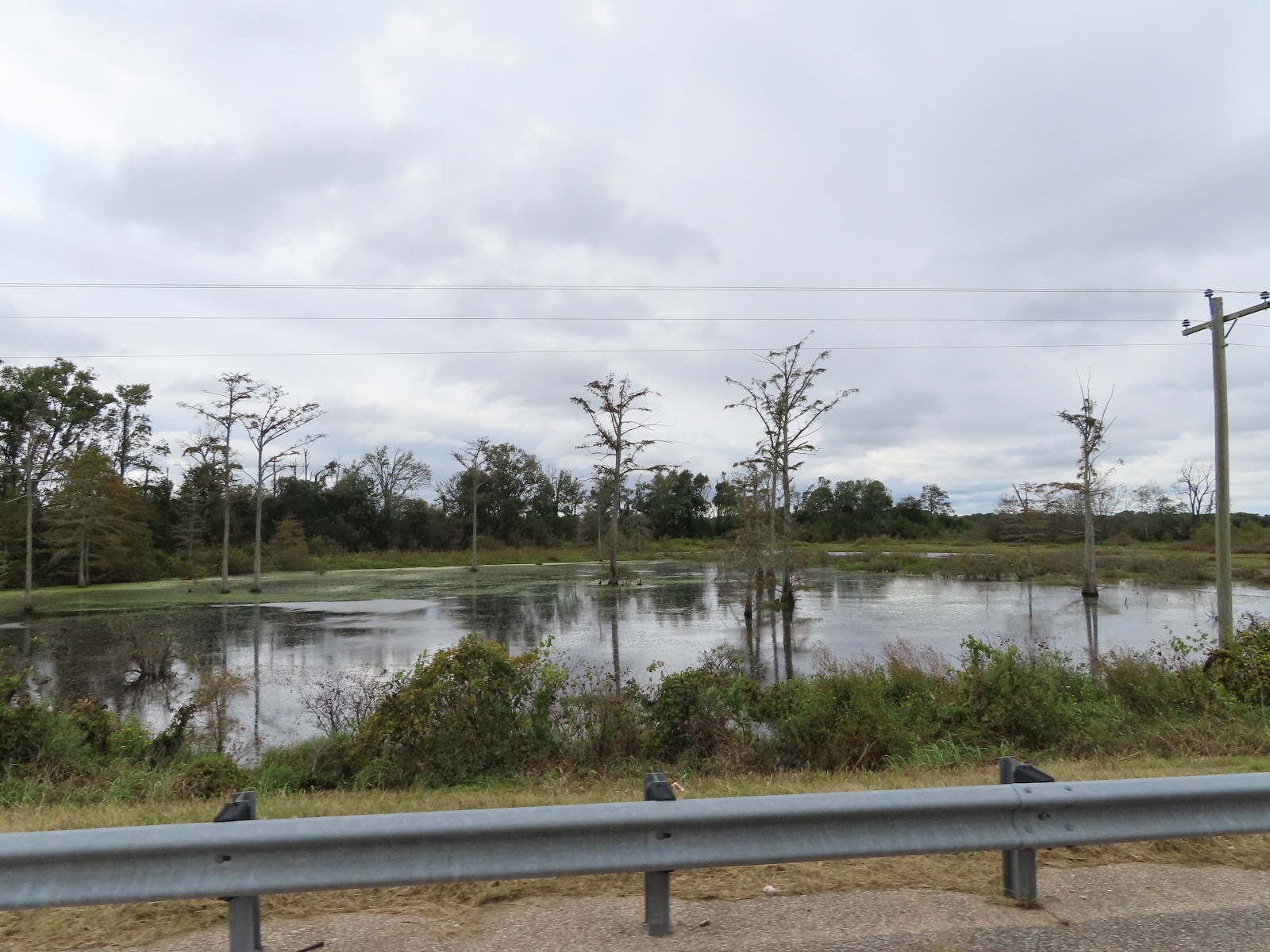
I took this picture and loved the reflection. I am calling it the “Arkansas Bayou.”

There are many Cat Fish Farms on Hwy 82 near Lake Village. I learned they feed the fish a soybean grain mixture to stop them from seeking food elsewhere in the ponds. Many politicians and entrepreneurs hoped catfish in the Mississippi Delta could become what chicken is in the Ozarks. That was before Vietnamese and Chinese fish flooded the American market. Today there are about a third the number of catfish farms there were in 2000, and they are making about half as much money. According to the United States Department of Agriculture, in 1998, 156 Arkansas catfish farms produced sales valued at more than $55 million. In 2013, 49 farms made more than $28 million.

Lake Village is located along the Great River Road National Scenic Byway and lies on the "C" shaped curving shore of picturesque Lake Chicot, a 20-mile long abandoned channel of the Mississippi River that is Arkansas's largest natural lake. Lake Chicot State Park offers cabins, campgrounds, a marina and other recreational assets. The downtown Jack R Rhodes Lakefront Park provides a community swimming area, walking path, small amphitheater, boat ramp and picnic pavilions.

Just before the Arkansas and Mississippi border, we crossed over the Mississippi River. The Mississippi River is one of the world’s major river systems in size and habitat. It is also one of the world's most important commercial waterways and one of North America's great migration routes for both birds and fishes. Native Americans lived along its banks and used the river for sustenance and transportation. Early European explorers used the Mississippi to explore the interior and the northern reaches of what was to become the US. Fur traders plied their trade on the river and soldiers of several nations garrisoned troops at strategic points, at various times, along the river when the area was still on the frontier. White settlers from Europe and the US arrived on steamboats displacing the Native Americans of their lands and converting the landscape into farms and cities.

We crossed from Arkansas to Mississippi. The Mississippi welcome sign boasts they are the “birthplace of America’s Music.” The University of Mississippi Blues Archive contains the world’s largest collection of blues music. The Mississippi Delta is the birthplace of Blues music, the only music recognized as truly original to America. The Mississippi Blues Trail, a virtual trail with markers throughout the state and beyond.

In Greenville Mississippi, we came across a guy walking that has lots of stuff. I am never going to assume someone is homeless, but he sure looks like he was down on his luck. Or he was just a serious collector of stuff. He had so much stuff, he would push one cart forward, then go back and get the second cart and push that one forward. It seems like a lot of work!

Leland is most noted for being the boyhood home of Jim Henson, creator of the Muppets. Along Highway 82 as you enter Leland you will find the Jim Henson Delta Boyhood Exhibit, made possible through a gift from the Henson Family. The Museum houses many artifacts and memorabilia from Henson's early creative years, and is a must-see for any Kermit enthusiast. The museum includes a real Kermit the Frog in a display case as well as an impressive Muppets collection. There's a kid play area with toys and puzzles and enough good museum items to impress adults. We were going to stop, but could not find a place to pull the RV and car off the road.

Indianola, Mississippi has had a number of names. It was first called Indian Bayou and then in quick succession became Eureka, Belengate, and then Indianola. Some people think that the name was from an Indian princess named Ola. But no matter how many names this town has had, Indianola is known around the world as one of the most important stops on Mississippi’s famous Blues Trail. In the 1880s, Indianola was a sawmill town, but it soon developed as a farming community. Agri-economy is still a big business, and the surrounding area produces cotton, soybeans, corn, rice, and plenty of catfish. It is located almost in the center of the Delta, midway between the Mississippi River and the rolling hill country, and is intersected by Highways 82 and 49, making it an important crossroads town.

The Moorhead Mississippi welcome sign boasts “Where the Southern Crosses the Yellow Dog.” Just what does that mean? WC Handy, "The Father of the Blues," immortalized the crossing of the Southern Railway and the Yazoo Delta (aka the "Yellow Dog") Railroad at Moorhead in his 1914 song "Yellow Dog Rag," better known under its later title, "Yellow Dog Blues." Handy wrote that he first heard the line "Goin' where the Southern cross the Dog" sung by a guitarist at the Tutwiler train station. Moorhead became a hub not only of rail transportation but of blues activity in local juke joints.

This past April, Mississippi Governor Phil Bryant signed Senate Bill 2458 that renamed a portion of US Highway 82 in Leflore County, which ran through the crash site, YANKY 72 Memorial Highway.

One year ago, a horror unfolded in a Mississippi Delta soybean field, when an East Coast Marine Corps Reserve KC−130T on its way to California went down. Fifteen Marines and one Navy corpsman perished that fateful day ― July 10, 2017. Six miles from that crash site, in Itta Bena, Mississippi, there is a monument to the victims. The “Yanky 72” memorial is named after the aircraft’s call sign. Clifton Addison, a Marine Corps League member and memorial committee chairman who led an effort that raised more than $100,000 for the memorial. Each man had a story. Some were fathers, brothers, husbands, friends – but each one was a proud member of our US Armed Services. Seven of the troops were with Marine Corps Forces Special Operations Command 2d Raider Battalion. They were traveling for pre-deployment training in Arizona. The rest belonged to the reserve unit Marine Aerial Refueling Squadron 452 out of Newburgh, New York.

Entering Greenwood Mississippi, their welcome sign explains they are the Cotton Capitol of the World. Is that possible? The wealth of the antebellum South was based on growing “white gold,” and Greenwood prospered into the Cotton Capital of the World because of its location. In the heart of the Delta and a high point on the Yazoo River, Greenwood was a prime shipping point to connect with the Mississippi River ports of Vicksburg, New Orleans, and St. Louis. Today, Greenwood houses the second largest U.S. cotton exchange, with about one fifth of the North America’s crop warehoused and sold here.

There was a bunch of ivy growing over everything along both sides of Hwy 82. It reminds me of the kudzu ivy that grows in Georgia! It’s monstrous green forms climbing telephone poles and trees on the edges of the roads. It was introduced from Asia in the late 19th century as a garden novelty, but not widely planted until the 1930s, kudzu is now America’s most infamous weed.

Just off the Winona exit on I-55 is a large cross. There is no associated church that is visible from either I-55 or Hwy 82. This is a cross without a church. We have seen large crosses before, but they were usually associated with a church, this cross is next to a Holiday Inn Express.

This was our longest day … there are just no campgrounds along this section of Hwy 82. We arrived at the Starkville KOA, it is on a lake, but the lake low, but we did capture an awesome sunset!

Day 110 of 117 on our “Go West, Young Man” Two Lane Adventure – Sunday 10/14/18


We departed the Shawnee Heart of Oklahoma Expo Center before 7:30 am. Jack and Jackie headed east of I-40, Charlie and I headed southeast on 177 S / 270 S / 3W East. We had a great time touring the Oklahoma City and Shawnee area. Jackie and I found the overall company that made the Guinness Book of World Record’s largest pair of overalls, but they were not on display outside of their factory.

The first town we came to was Tecumseh, the City of Tecumseh was born overnight when the town site was rushed by settlers in an 1891 Land Run, one of only two ever done for individual towns. The tent city that sprang up was named in honor of the Shawnee Chief Tecumseh, a famous Indian leader who fought with the British and died in the Battle of Thames in 1812. Two Presbyterian missionaries held church services at the courthouse square on the first Sunday after the land rush, although a saloon had already been established as had a hardware store, a bakery and a sawmill. Schools were established in 1892 and 1896, and businessmen organized and built their railroad connecting with the Choctaw Railroad east of Shawnee. Since Tecumseh was originally the county seat, a brick courthouse was built in 1897. But in 1930, Tecumseh lost the county seat status to Shawnee in a controversial election. The Tecumseh City Hall now stands on that historic spot.

We were greeted by this blazing Braum’s sign in the pre-dawn hours. Making ice cream and dairy products are second nature to the Braum Family. Their expertise spans three generations with over eight decades of history. It all started in 1933 at the beginning of the Great Depression, and the rest, as they say, is history. Peter Pan was the name of their first ice cream, sold both at their stores and in the grocery stores. In 1968, the first Braum’s Ice Cream and Dairy Store in Oklahoma City, Oklahoma. That year, twenty-three more stores opened throughout Oklahoma. By 1975, the Braum’s dairy herd, the largest dairy herd in Kansas moved to Oklahoma. This “modern-day cattle drive” consisted of over 900 cows traveling down the highway in a convoy of semi-trucks to their new home at the Braum Farm in Tuttle, Oklahoma. Over the years, this farm has grown to 24,000 acres, about 38 square miles. Becoming One of the World’s Largest Milking Operations. In 1993, Braum’s construction crews built what is touted as one of the largest milking operations of its kind in the world. 

Built on the Tuttle Farm, it consists of a milk barn and 17 free-stall barns (covering 35 acres) that house the Braum’s private dairy herd. Calves born and raised on the farm will eventually become part of the milking herd. In 2010, Bill Braum designed and built a “cow trolley” to transport the dairy herd to and from the milk barn. This eliminated the long walk several times each day and improved the cows’ overall comfort. Today, the Braum family owns and operates 280 stores located throughout Oklahoma, Kansas, Texas, Missouri and Arkansas. All Braum’s stores are located within a 300-mile radius of the Braum’s Processing Plant located in Tuttle. Their fleet of delivery trucks are on the road seven days a week delivering fresh product to each store every other day.

It was a dreary and overcast morning, as we drove. It was not a heavy rain, just annoying.

In the town of Asher, there was a long trail of red dirt on the road. There are still many county roads that are dirt in this area.  It is now a small community of just barely over 400 people, but it was once a bustling oil community that people in the area considered “the big city.” In 1892, George "Matt" Asher, from Kentucky, purchased land in Oklahoma Territory, and the town was named after Mr Asher when he opened his land, asking only that the community would carry his namesake. Asher became a “railroad town” in October 12, 1900, when the Choctaw, Oklahoma and Gulf (CO&G) bought the Shawnee to Tecumseh Railway branch from the Tecumseh Railway Company and promptly extended the branch to Asher. For 40 years, “Old Beck,” as the rail engine was called, ended and turned around in Asher, making the city a bustling trade center for the area.

In Oklahoma generally called the "South" Canadian River, the Canadian was known to seventeenth and eighteenth-century Spanish explorers as the Rio Buenaventura and the Magdalena. French explorers, perhaps assuming that the stream flowed northward into Canada, may have attached the name while they were seeking a route to Santa Fe. We have been criss-crossing this river for a few days.

In 1988 OK State Highway 3 between the cities of Ada and Broken Bow was dedicated as a memorial to the OK National Guard's 45th Infantry Division, a component of the US Army, for their service in WWII and the Korean Conflict. The 45th Infantry Division's long and distinguished history. The 45th Infantry Division of the US Army was a major formation of the Oklahoma Army National Guard from 1920 to 1968. Headquartered mostly in Oklahoma City, the guardsmen fought in both World War II and the Korean War. They trace their lineage from frontier militias that operated in the Southwestern United States throughout the late 1800s. The 45th Infantry Division guardsmen saw no major action until they became one of the first National Guard units activated in World War II in 1941. They took part in the attack on Salerno in the 1943 Italian Campaign. After landing in France during Operation Dragoon, they joined the 1945 drive into Nazi Germany that ended the War in Europe. After a brief deactivation and subsequent reorganization, the division returned to duty in 1951 for the Korean War. It joined the UN troops on the front lines during the stalemate of the second half of the war. The division remained on the front lines in such engagements as Old Baldy Hill and Hill Eerie until the end of the war, returning to the US in 1954. The division remained a National Guard formation until its deactivation in 1968 as part of a downsizing of the Guard. Several units were activated to replace the division and carry on its lineage. Over the course of its history, the 45th Infantry Division sustained over 25,000 battle casualties, and its men were awarded nine Medals of Honor, twelve campaign streamers, the Croix de Guerre and the Republic of Korea Presidential Unit Citation.

George and Clyde Welch built forts, played games and fished the ponds of a 42 acre tract of land in Oil Center. Little did they realize that someday that very same piece of land would be filled with the laughter of children and families enjoying the speed and thrill of watching their heroes of the dirt track take the checkered flag at Oklahoma Sports Park. They have worked hard to make the facility one of the best in the State. It's a Family Show, from the youngest to the oldest of race fans, they find a home here. Hundreds of spectators fill the stands on a normal race night and they never leave disappointed. If your looking for a great time, the thrill of victory, and sometimes an unexpected ending, this is the place to be on a Saturday night.

We skirted Ada on OK 3 East. In the 1890s families settled in the Chickasaw Nation in an area then called Daggs Prairie, named for the James and John Daggs families. Jeff Reed, an original settler, submitted his daughter's name for acceptance as the post office designation there, and on July 10, 1891, the settlement became known as "Ada." Ada was incorporated on April 1, 1901, and the first newspaper, the Ada Star, began circulation on the next day. The newspaper was a means by which organizations such as the Masons, the Sorosis, the Twentieth Century, and the 25,000 Club (which later became the Chamber of Commerce) reported their activities. The arrival of the St. Louis and San Francisco Railway line spurred rapid growth. Within a decade the Santa Fe and the Oklahoma Central lines also provided service. The town's many saloons, together with related problems, gave Ada a reputation for violence. In 1908 there were thirty-six murders. The lynching of four accused murderers, including the notorious "Shotgun" Jim Miller, by vigilante townsmen on April 19, 1909, was a symbolic end of the Old West.

We saw a sight, I have never seen. We saw a man doing puzzles along Oklahoma 3 near Centrahoma, Turned out it is called “Jigsaw Ranch.” Created in 2011, by John Cerney it is a set of 12 feet tall murals. The rancher is 'building' his cattle using jigsaw puzzle pieces. It is located on the property of Kim and Deward Strong. Deward is the rancher, seen in the mural.
In Atoka, we were going to take a break and get some breakfast at McDonald’s. However, the computers were down, so they could not take any order. One customer even asked if they could take an order, if we paid cash. Their answer was no. It is incredible, that because they had no computer, there was no service … I guess no one knows how to work without electronics anymore! It is becoming a sad reality …

This area of Oklahoma is rich in Choctaw history, the bad and the good. The Military Road is one the first highways connecting Arkansas to Fort Towson in the 1820s, which served as one route of the Choctaw Trail of Tears. Cut from Washington, Ark., to Fort Towson in 1831 for removal of Choctaws from Miss., became known is Choctaw Trail of Tears after thousands of suffering Indians used it to reach new lands. Road served as major east-west artery for Choctaw Nation until early 1900s. Imported early Choctaw settlements on road were Harris Mill, Eagletown, Lukfata. Wheelock and Clear Creek. Segments of road still identifiable still visible.

Oklahoma Indians have the distinction of being the first American Indian code talkers in both World Wars. Two forms of American Indian Code Talking exist: Type One or intentionally encoded native languages, and Type Two or non-coded native languages. While the former served as a foreign and coded language form usually with organized training, the latter served only as a foreign language and in impromptu situations. Among Oklahoma Indians only the Choctaw in World War I and the Comanche in World War II are known to have served as Type One code talkers. The first code talkers were a group of Choctaws in the 141st, 142d, and 143d Infantry Regiments of the Thirty-sixth Infantry Division in World War I. During the Meuse-Argonne campaign of 1918 in France, Germans broke Allied communication codes, monitored radio and telephone lines, and captured one of every four runners between companies. Needing a more secure means of communication, an American army officer overheard some Choctaw soldiers conversing in their native language. After an initial test and brief training in telephone messages, a Choctaw was placed in each post command. Coded words were soon devised for military terms foreign to the Choctaw language. For instance, "little gun shoot fast" meant machine gun. Choctaw messages transmitted by field telephone and in writing led to major successes in the battles of St. Etienne and Forest Ferme, contributing to the war's end.

In December 1940 the army recruited seventeen Comanches to become code talkers. Assigned to the Fourth Infantry Division's Fourth Signal Company at Fort Benning, Georgia, they received phone, radio, Morse code, and semaphore training. In August 1941 they were placed under Lt. Hugh F. Foster to develop an unbreakable Comanche-language code. Foster provided approximately 250 specialized military terms for which the Comanches developed coded equivalents. By October 30, 1941, the Comanche had completed their training and conducted field exercises in Louisiana soon thereafter. Thirteen Comanche Code Talkers landed at Utah Beach during the Normandy invasion in France. Maintaining wire telephone lines and sending secure messages via field telephone and radio, they served in France, Luxembourg, Belgium, and Germany. Their service included important battles at Cherbourg, St Lo, Paris, the Siegfried Line, the Huertgen Forest, and Bastogne. Although several were wounded in action, none were killed. The Comanche code was never broken. Efforts to identify and gain federal recognition for all American Indian Code Talkers led to the proposal of the Code Talkers Recognition Act in the 109th Congress. The Oklahoma Indian Code Talkers have contributed to a growing national awareness of American Indian Code Talkers and the importance of maintaining indigenous languages.

The clouds have cleared and the sun is shining now!

The Little River is a tributary of the Red River, with a total length of 217 miles. 130 miles of the river are in southeastern Oklahoma and 87 miles in southwestern Arkansas. It is also part of the watershed of the Mississippi River. Six large reservoirs impound the Little River and its tributaries. The Little River and its upper tributaries are popular for recreational canoeing and kayaking. We saw a sign for the Lost Rapids Park, which is a Corps of Engineer park.


The town of Broken Bow was incorporated and the post office established in 1911. Although Broken Bow was located on land previously owned by Choctaw, it did not receive its name from its local American Indian roots. Instead, it was named after Broken Bow, Nebraska, the home of Herman and Fred Dierks, who had moved to southeastern Oklahoma to establish the Choctaw Lumber Company. The area platted for Broken Bow was at the eastern terminus of the Texas, Oklahoma and Eastern Railroad. The land on the north side of the tracks was designated for residences, schools, churches, and retailers. The land south of the tracks was reserved for the lumber mill, employee housing, and other parts of the Choctaw Lumber Company. The firm provided a doctor for its workers and their families and built a hospital chiefly for the company employees but open to anyone needing care.

By 1923 Broken Bow enjoyed a public water and sewage system and electric lighting. Five churches, two elementary schools, a high school, and thirty-two businesses were established. There were three lawyers, two dentists, and five physicians. At the beginning of the twenty-first century timber remained the economic base of Broken Bow. The Dierks brothers sold their holdings in Oklahoma and Arkansas to Weyerhaeuser Company in late 1969. Included was the Broken Bow mill, then one of the largest lumber mills in the nation. Another important business in the area is Tyson Industries' chicken-processing plant. Originally established by Lane Industry in 1970, the Broken Bow plant currently processes an average of one million birds per week.

We crossed the Oklahoma state line into Arkansas. But, we lost our sunshine!

In DeQueen Arkansas we moved off our Route 3 and turned onto Route 71 / Route 59. Route 3, made like a stair step action heading toward Texarkana, but this route is more like an inverted L heading into Texarkana. Since our campground is on the north western side of Texarkana in Texas, taking this route makes sense. The history of the City of De Queen is entwined with the construction of the Kansas City Southern Railroad. The Kansas City Southern railroad connects Kansas City, Missouri to the Gulf of Mexico at Port Arthur, Texas. The KCS railroad was extended through a frontier settlement known as Hurrah City, that later became De Queen. De Queen was named after Jan de Goeijen, a Dutch coffee merchant who helped finance the completion of the railroad. However, de Goeijen’s name was difficult for area residents to pronounce and the name was eventually changed to De Queen. The City of De Queen became the county seat of Sevier County in 1905 and has steadily grown into a prosperous community.

I think today is the day we crossed the most state lines. We just crossed from Arkansas into Texas!

We arrived at Texarkana KOA, just below the raised entrance ramps for Interstate 30 … hopefully, we are low enough for the road noise to travel right over us for the night! We were on a few pins and needles tonight, as tornado watches were on and off for our area. All was well, when we went to bed!