Monday, September 20, 2021

September 17th, 2021 … Summer of Fun continues! Alabama into Georgia

Gunter Hill Campground lies just 15 minutes and a world away from I-65 and the bustle of downtown Montgomery. At Gunter Hill, paved roads lead serenely through tall pines and mature hardwoods draped with Spanish moss, terminating at the banks of Catoma Creek, a backwater of the Alabama River. 

After passing the gatehouse at the main entrance, the park road forks, offering two loops: the Antioch and Catoma loops. The Antioch Loop is a relatively direct path to the river, the paved park road passes beneath a canopy of mature pines and bottomland hardwoods. We camped in this loop. Gunter Hill Park is one of the state’s undiscovered gems. The park is fully staffed and well-maintained, offering a peaceful scene of trees and nature on the backwaters of the Alabama River.

Before the state of Alabama was even established, the site of present-day Montgomery was an important crossroads that straddled major Native American trade routes, with paths, streams, and the Alabama River connecting the Creek Indians to a wider world. Beginning in the sixteenth century, European intrusions began changing the destiny of the original inhabitants. By 1814, with the signing of the Treaty of Fort Jackson, the Creeks had ceded millions of acres, including what is now Montgomery County, to the United States. Located in the heart of central Alabama, the city of Montgomery holds a strategic place in state, national, and international history. A frontier settlement, it became a center of the cotton kingdom, Alabama's seat of government, and the original Confederate capital. Later, the 1886-87 Lightning Route electric trolley system and in 1910 the Wright Brothers' civilian flying school brought it recognition as a center of technology. During the turbulent civil rights era, Montgomery citizens played a central role in some of its most important events, including the bus boycott and the Selma to Montgomery March.

I found this intersection thought provoking. Rosa Parks Ave & South Blvd. Rosa Parks was called "the mother of the civil rights movement." Rosa Parks invigorated the struggle for racial equality when she refused to give up her bus seat to a white man in Montgomery, Alabama. Parks' arrest on December 1, 1955 launched the Montgomery Bus Boycott by 17,000 black citizens.

In December 2014, Trenholm State Community College was granted initial accreditation by the Southern Association of Colleges and Schools Commission on Colleges (SACSCOC) to award associate degrees. The John M. Patterson State Technical School was established as a result of the 1947 passage of Regional Vocational and Trade School Act 673 by the Alabama State Legislature. The Montgomery County Board of Revenue and the City of Montgomery purchased 43 acres of land at the junction of the Southern Bypass and U.S. 231 South in 1961.  The school opened on September 4, 1962. Patterson was named a technical college by action of the State Board of Education in 1974.

Sweetcreek Farm Market, I would love to stop, but there is no place to park an RV towing a car! But Sweetcreek Farm Market is a farm-to-table market where they sell local, fresh produce, signature sandwiches, homemade ice cream, fresh baked goods, home-blended coffees and gifts. The big cow is a plus!

Union Springs, a small historic town, we passed through on US 82. The picturesque downtown and the surrounding residential streets show what makes it uniquely and genuinely Southern. From antebellum homes to one of the oldest jails in the state to cemeteries dating back nearly 200 years, Union Springs is a showplace of Southern history, architecture, and charm. Naturally, I had to take a picture of the purple house! It’s historic, even with that color scheme! The Cope-Parsley House built in 1903. It’s a Queen Anne style enhanced with turret finials and small leaded glass windows on the tower. It has a large verandah and was built by E.H. Cope.

A major battle was fought with the Native Americans near Midway on the Pea River with General William Welborn leading the settlers. The battle of Hobdy’s Bridge was the last battle fought with Native Americans on Alabama soil, and the fiercest of the conflict. Among the first people to homestead in the area of present day Bullock County were several Scotchish families who settled at Bethel, which was at the time a part of present day Pike County. They spread to Inverness and Aberfoil. It is said that they built their church before they built their homes. Most of the early settlers came from the Carolinas and Georgia. Wealthy people settled on the Ridge because of the fertile soil and water supply. From these settlements grew a society unsurpassed with a culture and prosperity typical of the “Old South”. The first church, “Old Ebenezer” was built on Bullock soil was for these people. Other settlements were made at Midway, Enon, Guerryton, Suspension, Chunnennuggee, and Union Springs.

Our last town in Alabama was Eufaula. It is nestled high upon a bluff overlooking the beautiful 45,000-acre Lake Eufaula, along the Alabama-Georgia border. Along the main street in Eusaula is a Confederate Monument. The shaft is of Georgia granite, beautifully polished so as to produce two shades of gray, and is thirty-five feet high.  On top of this, exquisitely carved in Italian marble, is the statue of a private Confederate soldier, with his accouterments, standing "at rest".  The presentation of the monument to the city, in the name of the Barbour County Chapter of the United Daughters of the Confederacy, was made by Miss Mary Clayton, the organizer of the Chapter and a daughter of Gen. H. D. Clayton. 


This statue in honor of the Reverend Marton Bryan Wharton is located at the intersection of Randolph Street and the Barbour Street, also the US 82. It stands in the center of the intersection facing the church where he was pastor twice, the First Baptist Church of Eufaula. The statue is made of white marble, stands about 15 to 20 feet tall. He was born on April 5, 1839 in Orange County VA and died on July 20, 1908 in Atlanta, GA. Originally called the Irwinton Baptist Church, when the town name changed to Eufaula, so did the church! This is the 2nd permanent location of the church, the 1st location burned to the ground from a lightning strike in 1907.


On US 82, when you leave Alabama and cross over into Georgia, you cross over the Chattahoochee River into Georgetown, Georgia, over Lake Eufaula, on the Walter F George Reservoir and onto the Ernest Vandiver causeway.


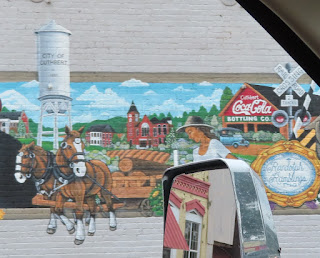
The route then crosses into Cuthbert Georgia. Unique fact, one of the only water towers erected in the middle of a federal highway (US 82) stands in Cuthbert, the county seat of Randolph County.


Cuthbert’s Historic District boasts architectural styles spanning most of the county’s history, and many of the buildings, originally built around 1890, are still standing on the town square today.


There were several new murals in the downtown area, which I don’t remember.


One of them an area called Magnolia Alley. There is new landscaping hardscapes to round out the wall murals that Andrew College Mural Artist Chris Johnson painted. The mural work was made possible with the support of a Tourism Product Development Grant.


Usually, we are heading to the west coast of Florida, so we cut down Route 19. This year, we are heading to the east coast, so we are continuing on Hwy 82. The next town we came to is Dawson, Georgia. To me, it’s a tale of two cities. Dawson, Georgia’s historic residential districts, featuring unique and beautiful architecture ranging from Victorian to Antebellum style. Some are in pristine condition and others have been left to wither and disappear, just like all the memories made there.


In 1893, a community known as "Isabella Station," was established and became the county seat of Worth County, when the Brunswick and Albany Railroad entered the region. Gradually, more communities were founded along the railroad. In 1894, the residents of Isabella Station voted to change the community's name to "Sylvester" in honor of a prominent local family. Sylvester was incorporated on December 21, 1898. Today, the community celebrates the Georgia Peanut Festival in October every year. This festival includes the Peanut Parade, an annual dance called Goober Gala, an arts and crafts show, the Miss Georgia Peanut pageant, and peanut cuisine.


The city's first courthouse burned down in 1879, but a new one was built in 1893. However, this too was damaged by fire. Following the burning of the new Worth County courthouse in 1982, Max Hufstetler was convicted as an arsonist.


We arrived at the Tifton KOA, our home for the night.

#TwoLaneAdventures

Sunday, September 19, 2021

September 16th, 2021 … Summer of Fun continues! M-i-ss-i-ss-i-pp-i

We departed the Starksville KOA and it was misting and it was overcast. So, this KOA is on Okibbeha County Lake. Back in 2018, they had drained a portion of the man-made lake to repair the levee, but the repair was never made and the lake level remains low. The Wet N Wild Beach area of the KOA is sitting there, hundreds of feet away from the lakes edge and the future of the Oktibbeha County Lake Water Park remains undetermined. Over the past few years, there has been a lot of discussion and concern about the Oktibbeha County Lake Dam's levee system and its ability to contain the heavy rains the Starkville area receives.

The Emergency Management Association and others have worked together to alleviate the pressure from the levee near Starkville KOA. Since the initial concern over the dam breaking, two sinkholes have been discovered. There has been a lot of discussion of whether the waterpark at the KOA, Wet-n-Wild, would be open the summer of 2021. The water park has been closed for around five years. There was talk of it reopening this summer, but the most issues with the levee prevented it from happening. The woman who owns the water park said if the levee is fixed and the water levels can be safely regulated, the water park has a higher chance of reopening. As far as a complete repair of the levee is concerned, city workers and engineers continue to work on the issue. No official finish date has been determined.

We crossed the Tennessee-Tombigbee Waterway, often called the Tenn-Tom, is a 234-mile man-made waterway that extends from the Tennessee River to the Tombigbee River connecting major inland ports from Paducah, Kentucky to Knoxville, Tennessee. It links commercial navigation from the nation's midsection to the Gulf of Mexico. The major features of the waterway are 234 miles of navigation channels, cut 280 feet wide, a 175-foot-deep cut between the watersheds of the Tombigbee and Tennessee rivers, and ten locks and dams. This 29-mile portion of the waterway connected the Tenn-Tom with Pickwick Lake, which forms the border between Alabama and Mississippi in the northwestern corner of the state.  

Columbus, originally called Possum Town is situated at the juncture of three rivers: the Tombigbee, The Buttahatchie, and the Luxapalila. Hernando de Soto crossed the Tombigbee River in 1540 into this area. William Cooper had a trading post near here in the 1780’s. Columbus has managed to progress as a city, while still honoring those who came earlier and forged a path. Since before the town was chartered in 1821, men and women of character and intellect had already staked their claim on the area. At that time, the still-new United States was offering land grants to anyone who could work the land. United States military officers came through here during the War of 1812, and some decided that someday, they would return to this lush and lovely land. A few did return, and built the plantations Goshen, Belmont and others after they cleared wilderness for homesites. The nation’s first state-supported college for women was organized in 1884 and the city settled into a life of culture and prosperity. Columbus is also the birthplace of playwright Tennessee Williams, whose home is now the Welcome Center on Main St.

Columbus Air Force Base is also located in Columbus, Mississippi, and is home to the 14th Flying Training Wing, Air Education and Training Command. Columbus is considered a low-cost military town and is home to many retirees. The mission of Columbus AFB is "Produce Pilots, Advance Airmen, Feed the Fight." The 14th Flying Training Wing, under the Air Education Training Command (AETC), is responsible for an intensive 52-week Specialized Undergraduate Pilot Training (SUPT) program.

Centreville is a small town in rural southwest Mississippi that developed in the late nineteenth century on either side of the railroad tracks laid by the Yazoo and Mississippi Valley Railroad. The community that evolved to become the railroad town of Centreville began as a settlement known as Elysian Fields or Amite Courthouse. The name of the town derives from its geographic location in the center between the county seats of Liberty and Woodville and between the larger cities of Natchez and Baton Rouge. Soldiers from all across America were introduced to Centreville in 1942, when Camp Van Dorn, the nation's third largest armed services training camp was established. Located only three miles from downtown Centreville, Camp Van Dorn encompassed 41,844 acres and had barracks to accommodate 39,114 enlisted men and 2,173 officers. Camp Van Dorn bolstered the local economy during the war years. Surprisingly, the impact of approximately 40,000 soldiers on the physical appearance of the town was minimal.

General Andrew Jackson’s defeat of Chief Menewa, Red Eagle and the Red Stick Creeks at the Battle of Horseshoe Bend in 1814 opened the door for the migration of white settlers primarily from Georgia and the Carolinas to this region of the Mississippi Territory.  By the time Alabama gained statehood in 1819, pioneer families had established a foundation for the town of Maplesville near Mulberry Creek.  The town’s namesake was Stephen W. Maples, a merchant whose store held the first post office.  The community became a crossroad for the Fort Jackson Road, which connected Tuscaloosa to Coosada and Montgomery, and the Elyton Road which connected Selma to points north.  Inns and taverns were built to accommodate the stagecoach traffic with the area’s population increasing to 809 by 1850. In 1853 the Alabama and Tennessee Rivers Railroad was completed at the nearby community of Cuba.  The citizens of Maplesville began migrating to the new Maplesville Depot thus initiating the decline of the original town.  In 1856, the Maplesville Post Office was located to the new site effectively changing the name of the community.  By 1900 old Maplesville had become a ghost town and today little remains other than the cemetery.  The addition of the Mobile and Ohio Railroad in 1897 brought good times to the town for the next 20 years.  Many of the older buildings seen in town today were built during that period.  Over the years three depots have served the Norfolk Southern Railroad and its predecessors.  The first was built around 1853 and was destroyed by Wilson’s Raiders on their march to Selma during the War Between the States.  The second was built shortly after the war and burned along with a number of other buildings in the fire of 1911.  The present structure was built in 1912. 

We crossed from Mississippi into Sweet Home Alabama. Tourists traveling into Alabama on the interstate highways are greeted by signs strengthening the state’s official connection to the Lynyrd Skynyrd song title “Sweet Home Alabama.” Before 2014, “Alabama The Beautiful” signs stood at the state line since 2003. Lynyrd Skynyrd recorded several songs in Muscle Shoals, Alabama, but “Sweet Home Alabama” was recorded in Doraville, Georgia, in 1973.


There was a bunch of ivy growing over everything along both sides of Hwy 82. It reminds me of the kudzu ivy that grows in Georgia, perhaps it has migrated west! Its monstrous green forms climbing telephone poles and trees on the edges of the roads. It was introduced from Asia in the late 19th century as a garden novelty, but not widely planted until the 1930s, kudzu is now America’s most infamous weed.

The Talladega National Forest offers a peaceful atmosphere that is filled in wild game, camping, and hiking utopias. The forest also features picturesque scenic waterfalls throughout its striking setting. The total Forest covers 392,567 acres at the southern edge of the Appalachian Mountains. Before it was bought by the federal government in the 1930s, the area that comprises the Talladega was extensively logged and represented some of the most abused, eroded wastelands in all of Alabama. Pine forest regrowth now hosts a diverse eco-system. The forest is headquartered in Montgomery, as are all four of Alabama’s National Forests. The other National Forests in the state are Conecuh, Tuskegee, and William B. Bankhead. The Talladega National Forest is physically separated into two areas, and divided into three Ranger Districts.

True to its name, the Alabama River flows through the heart of the state of Alabama. Originating just north of Montgomery, the Alabama River is born from the marriage of the Coosa River and the Tallapoosa River near the Fall Line. As with most of Alabama’s great rivers, dams slow the progress of the Alabama River as it flows to meet the Tombigbee River and form the Mobile River.  All of the Alabama River downstream of Montgomery is commercially navigable.


Even through the rain drops, we had our first Love Bug sighting. Actually it was a joined set of love bugs. Yuck …. It’s one of the toughest seasons in the south!


We arrived at Gunter Hill COE campground, our home for the night.


The site we picked from a map is just perfect, we spent the afternoon outside sitting, relaxing and a little bit of napping!

Saturday, September 18, 2021

September 15th, 2021 … Summer of Fun continues! Arkansas & Mississippi!

It’s beginning to look a little like fall, as we departed Crossett Harbor RV Park and headed into the town of Crossett. It was named after Edward S. Crossett, a leading entrepreneur in the lumber industry's emergence in Arkansas. In May 1899, Crossett joined with three partners to form the Crossett Lumber Company, which then sought to build a lumber mill in the town of Hamburg. Displeased with the reception the proposed mill was receiving there, the company selected a site in the forest about 12 miles southeast of Hamburg, where Crossett was born as a tent city constructing the company's mill.

Lumber from initial milling operations was used to build a permanent mill, company offices and employee housing. Crossett remained a classic "mill town" into the mid-1940s with Crossett Lumber owning all the town's homes and businesses until 1946. Though some early lumber towns were abandoned when the supply of harvestable trees was exhausted, Crossett's future was secured through improved forest management practices and through the manufacture of diverse forest-related products, including wood alcohol, turpentine, chemicals needed by soap and paint manufacturers, charcoal, food board and flakeboard.

Felsenthal Wildlife Refuge was established in 1975. It is located in southeast Arkansas. Named for a small community located at its southwest corner, this 65,000 acre refuge contains an abundance of water resources dominated by the Ouachita and Saline Rivers and the Felsenthal Pool. The low lying area is dissected by an intricate system of rivers, creeks, sloughs, buttonbush swamps and lakes throughout a vast bottomland hardwood forest that gradually rises to an upland forest community. Historically, periodic flooding of the "bottoms" during winter and spring provided excellent wintering waterfowl habitat. These wetlands, in combination with the pine and upland hardwood forest on the higher ridges, support a wide diversity of native plants and animals.

We saw the Georgia Pacific Softwoods Lumber Division, Stud Mill. Georgia-Pacific bought the mill and plywood plant in 1962 and shortly afterward began producing tissue paper at the site. Later that decade, it added a chemicals plant. Georgia-Pacific eventually closed the plywood plant, which burned down last year, and sold its chemicals division. Koch Industries bought Georgia-Pacific for more than $13 billion in 2005 and took the public company private. Today, the Crossett facility is the company's second-largest paper mill, King said. The Crossett mill sits along a stretch of Arkansas 82, known locally as First Avenue. A parallel rail line separates the complex and its smokestacks from the heart of town, but the mill looms over a nearby grid of homes, businesses, schools and public buildings. More than a dozen residential streets spill onto First Avenue. The mill employs about 1,200 people from Crossett, other Arkansas towns and Louisiana.


We went by what used to be a gas station? A car wash? But … now it is an RV park? I guess if you own it, you can park whatever you want on it??

We came into Hamburg, it was laid out in October 1849. Two months after Ashley County was formed from part of Drew County in the area earlier known as the Great Wilderness. With the town’s designation as the county seat, two of the first public buildings were the courthouse and the county jail, erected in 1850. During the Civil War, Hamburg helped provide troops to the Confederacy, with several companies of the Third Arkansas Infantry that fought with the Army of Northern Virginia, commanded by Hamburg lawyer Van H. Manning. The town escaped military action during the war, though state militia briefly occupied it during Reconstruction under Governor Powell Clayton’s proclamation that several counties, including Ashley, were in rebellion. Though there were instances of violence throughout Reconstruction, the proclamation was most likely in opposition to the conservatives who remained in control of the county and its government. The current city’s economy is divided among agriculture and forestry due to the town’s geographic location. Immediately east and west are prairie regions dedicated to rice and soybean culture.

There are many Cat Fish Farms on Hwy 82, between Crossett and Lake Village. I learned they feed the fish a soybean grain mixture to stop them from seeking food elsewhere in the ponds. Many politicians and entrepreneurs hoped catfish in the Mississippi Delta could become what chicken is in the Ozarks. That was before Vietnamese and Chinese fish flooded the American market. Today there are about a third the number of catfish farms there were in 2000, and they are making about half as much money.

While Lake Village was not incorporated as a town until 1898, the history of the area starts much earlier, beginning with the arrival of the Spanish in 1541. One local story claims that Hernando de Soto and his men came upon a friendly Native American tribe ruled by Chief Chicot, who had their village on the banks of the Mississippi River at the present-day site of Lake Village and who gave de Soto and his men food and skins for clothing. Though Hernando de Soto did die in 1542 at an Indian village likely near what is now Lake Village, there is no evidence of a Chief Chicot in the chronicles of the expedition. The names of Chicot County and Lake Chicot likely derive from a French word meaning “stump,” in reference to the many cypress knees in the area.

Lake Village is located along the Great River Road National Scenic Byway and lies on the "C" shaped curving shore of picturesque Lake Chicot, a 20-mile long abandoned channel of the Mississippi River that is the largest natural lake in Arkansas and the largest oxbow lake in North America. Lake Chicot is nationally known for its ability to produce record largemouth bass, Lake Chicot also offers an abundance of crappie, bream and catfish for the avid angler.

We crossed into Mississippi, does everyone become a little sing-song like when you say Mississippi? Like you are a little kid in school learning how to spell it? Arkansas borders Mississippi to the east, with the Mississippi River forming the boundary between the two states. Like most rivers, the Mississippi River keeps shifting the border between the two states.

Greenville was named after its founder, General Nathaniel Green, who was a friend of George Washington. It was mostly destroyed in the Civil War, but was later reconstructed. It is in Washington County, which was founded in 1827. Greenville suffered its first flood in 1890. After four decades, the Federal Government established flood control in the area and rescued the river towns. I love this welcome center, it’s a one of a kind location.

This bridge over Deer Creek was named after the infamous song from 1979 film, The Muppet Movie in honor of Jim Henson who was the mastermind behind The Muppets franchise. It was marked by a brightly colored sign with a waving Kermit. I had expected the Rainbow Connection Bridge to be colorful, like Fozzie’s Studebaker after Dr. Teeth and the Electric Mayhem got their paint cans all over it. Instead, only the guardrails were painted and only a solid green, but less Kermit green and more army men green. It ain’t easy bein’, green!

The bridge is located just down the road from The Birthplace of Kermit The Frog Museum in Henson’s boyhood town of Leland, Mississippi, which hosts the annual event. The annual event celebrating Jim Henson and the Muppets is held at The Rainbow Connection Bridge in honor of Jim Henson. 2021 marks the 10th Anniversary of the Frog Fest Festival, this October. There is food, drinks, music, and of course a nice stroll around Deer Creek!! Attendees tend to dress as their favorite Muppet, all in honor of Kermit the Frog!

The climax of all things Muppet was the first three minutes of the 1979 The Muppet Movie. Kermit, sitting on a log by himself in his home swamp, playing the banjo, and singing wistfully about rainbows and lovers and dreamers while carefully separating himself from them. That was it, it summed up everything that was right about the Muppets and the life work of Jim Henson. Actually, Kermit the marionette-puppet was born in Maryland, when Jim Henson was attending college and putting his home economics degree to good use. However, in the Muppet-verse, the character of Kermit hails from a small town called Leland, Mississippi, on the winding western edge of the state, a town which is more or less the childhood home of Henson himself. Henson was born next door in Greenville, and his family lived at an agricultural experiment station where his father worked, in nearby Stoneville. He went to elementary school in Leland with a friend of his named Kermit Scott.

“Leland, Mississippi: Birthplace of the Frog.” It is next to a small, weathered, wood-paneled building with another bright-green Kermit waving from a window. Most of the items on display were donated by the Henson family. In one case was a replica of Kermit himself, sitting in a swamp diorama, holding a banjo. In the other were the original puppets used in the “The Song of the Cloud Forest” bit in the “Fitness” episode of The Jim Henson Hour from 1989.

Indianola, Mississippi has had a number of names. It was first called Indian Bayou and then in quick succession became Eureka, Belengate, and then Indianola. Some people think that the name was from an Indian princess named Ola. But no matter how many names this town has had, Indianola is known around the world as one of the most important stops on Mississippi’s famous Blues Trail. In the 1880s, Indianola was a sawmill town, but it soon developed as a farming community. 

The story of Indianola, Mississippi, is a veritable tale of two cities. On its surface, Indianola is rich with history and seems like an opportune place to live. It’s the home of blues legends Albert and B. B. King and of the first black female Postmaster, Minnie Cox; and it’s the seat of power for Sunflower County. Yet times have been tough in Indianola. Many of the agricultural and manufacturing jobs that long buoyed the city’s economy are now obsolete, and other jobs moved overseas. Delta Pride, a large catfish processing plant, closed its doors in 2011, and a lot of people are now out of work. It is located almost in the center of the Delta, midway between the Mississippi River and the rolling hill country, and is intersected by Highways 82 and 49, making it an important crossroads town.

The first settlement on the banks of the Yazoo River was a trading post founded by John Williams in 1830, and known as Williams Landing. The settlement quickly blossomed, and in 1844, was incorporated as Greenwood, named after Chief Greenwood Leflore. Growing into a strong cotton market, the key to the city's success was based on its strategic location in the heart of the Delta. The city prospered as a shipping point to New Orleans, Memphis, and St. Louis, Missouri until the latter part of the Civil War.

Yazoo River, river formed by the confluence of the Tallahatchie and Yalobusha rivers north of Greenwood, Mississippi, U.S. It meanders about 190 miles generally south and southwest, much of the way paralleling the Mississippi River, which it joins at Vicksburg. The Yazoo flows with only a slight gradient.


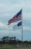
Mississippi sure does like their large crosses! And they are proud to fly a flag of faith! This flag was at a business, not at a church!

We arrived at Starkville KOA. We have been here before, but it’s a great overnight stop. Easy in and easy out. 


I’ll tell you more about the lake in the morning, but this afternoon we enjoyed sitting out and watching the birds!


We ventured out to dinner at Applebee. They had a table set and dedicated to the 13 servicemembers killed in Afghanistan. Tetrena was the bartender and she was our waitress too. She was so friendly and full of life! We enjoyed our meal there and her company! You can tell it has been a while, since we have eaten out ... I forgot to take a picture of my food!


It was a pretty sky, when we got back to the rig! #TwoLaneAdventures