Sunday, June 16, 2019

Two Lane Adventure in New York – Thursday, May 30th 2019


Today we traveled the long Two Lane Adventure, 24 miles, from Donny & Donna’s house in Cohocton to the Hemlock Fairgrounds. We drove north on State Route 415. Route 415 parallels in part, the Cohocton River and I-390. The northern end is at a junction with NY 15 and NY 21 south of the village of Wayland. Where we turned north on Route 15.

Wayland is one of the first civil divisions in the county, and was formed from Cohocton and Dansville in 1848. Wayland now covers 23,400 acres of land. It is flat with rolling hills in the north and moderately hilly in the south. The highest ridges are approximately 1,800 feet above sea level, and form a portion of the watershed between Lake Ontario and the Susquehanna. Loon and Mud Lakes are situated in the rich valley in the south part of the town, but their waters flow in opposite directions.

Some of the early institutions of Wayland, were a saw mill, grist mill, a tavern, the first school built in 1811 and a hotel at Patchin's Mills in 1824. The plank road from Patchinville to Dansville was constructed about 1842. Outside of these old industries Patchin's Mills, or Patchinville, has not attracted any considerable attention to the history of the town. The same may also be said of the locality known as Loon Lake, an attempt was made to establish a summer resort, but with indifferent success. Wayland in the north part, and Perkinsville near the center of the town, are thriving villages, and are the centers of rich agricultural regions. The town at large yields well in farm products, potatoes being the special crop grown and affording excellent returns.

Besides farming, the main industry in Wayland now in Gunlocke. But why in Wayland NY? The Gunlocke heritage has deep roots in Wayland, their New York community. One of their most valuable assets, the Gunlocke Brand, embodies a long heritage in this community. In 1902, William H Gunlocke and four other wood furniture experts acquired a vacant factory in Wayland. They established the W. H. Gunlocke Chair Company, which initially specialized in seating for homes, libraries and lounges. In 1920, Gunlocke was awarded its first National Contract with Western Electric. 

Due to this contract, demand for Gunlocke’s office seating was so strong that the company discontinues its household furniture to concentrate on manufacturing for the corporate market. Fast forward to 1970, Gunlocke expands its headquarters to 665,000 square feet and began manufacturing case goods.  Although, the factories business is dwindling, it is still the biggest employer in the town.


One of my favorite things in Wayland is the well-kept and painted shake & shingle siding on the homes. There are two of them right on Route 15. The first home has a simple color pattern.

The second home has a much more colorful appearance. Since it has some purple, it is my favorite!

After Wayland, you come out of the village and start to climb a hill. At the crest of the hill, is the barn I spoke of in another blog. The advertising is painted over, but the barn still stands!

Just past the barn is a “buggy crossing” sign. Some Amish have moved into the area. There is even a hitching post at the new Dollar General store in town.

Going down into the valley of Springwater. In the early days, the only known inhabitants were Indians from the Seneca tribe, part of the Iroquois Confederacy and a few trappers who periodically wandered in this direction. They were the keepers and custodians of the western gate of the Iroquois Indians.

From Springwater, you head north on Route 15A. Route 15A heads due north from Springwater toward Hemlock Lake. The route heads northward as North Main Street, proceeding along the eastern base of the valley as it passes through the northern half of the community.


In 1806 after the harvest, the first known white resident, Seth Knowles, having observed from his drought-ridden farm in Livonia that clouds formed and rested on the hills regularly to the south and frequently rain fell. They followed an Indian trail over Bald Hill in the Town of Canadice to Springwater Valley. About a mile from the head of Hemlock Lake, they made a small clearing and built a small log cabin. They returned to winter in Livonia and at the of March 1807, Mr. Knowles and his family came up Hemlock Lake on the ice and took possession of that cabin, becoming the first of many settlers that would follow them in the ten years prior to an official town of Springwater being organized, in 1816.


Outside of Springwater, NY 15A enters a rural, undeveloped area dominated by dense forests to the east and a low-lying, slightly more open area to the west. This area of Route 15A was named Springwater Veterans Memorial Highway.

As the route approaches the Livingston–Ontario county line, the lowlands give way to marshes, which in turn lead to Hemlock Lake at the county line. While in Ontario County in the town of Canadice, NY 15A follows a more inland route to the east, passing through an isolated forest situated between Hemlock and Canadice Lakes. This area of Route 15A was named Canadice Veterans Memorial Highway.

Oh, the spectacular views! At the crest of the hill is Rob’s Trail Preserve. It’s a collection of trails among the high ridges and rolling hills of the Finger Lakes. Completed in 2008, Rob’s Trail—Canadice was built to connect two undeveloped lakeshore properties that protect Hemlock and Canadice Lakes, the main source of Rochester’s drinking water supply. With the help of donors and volunteers, a new trail, Rob’s Trail—Hemlock Lake, was built in 2016 that makes it possible to hike from one lake to the other.

The Central & Western Chapter of The Nature Conservancy built these trails to honor the memory of Rob van der Stricht, the board chair who passed away in 2006. Rob was an avid birder, canoeist, and fisherman who carried a broad smile and a pair of binoculars everywhere he went. He was especially fond of the Finger Lakes, particularly Hemlock and Canadice. His commitment to preserving nature inspired us all, and The Nature Conservancy officially dedicated this trail to his memory. Once a hardwood forest converted to cropland, Rob’s Trail showcases ecological communities, scenic vistas and geological features typical of the Finger Lakes Region. Hemlock and Canadice are the only Finger Lakes with undeveloped shorelines.

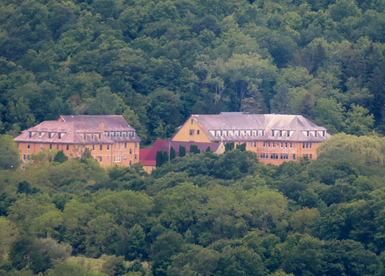
From this vantage point, you can see the old mission. The Divine Word Missionaries called the holy ground or sacred space where they lived, prayed, studied, and died between 1924 and 1984 on Hemlock Lake by a variety of names, starting with St. Bernard’s (1924–1936), St. Michael’s Mission House (1937–1957), and Divine Word Seminary (1958–1984). Some of the lore and legend of how Father Hugo Aubry had a hand in naming the location after St. Michael the Archangel. The history of Saint Michael’s Mission began when the priests and brothers came to Conesus to continue the operation of Bishop McQuaid’s vineyards. Eventually, it became a preparatory seminary for young men studying Theology. Saint Michael’s Mission is located on the west slope of Hemlock Lake. 

The highway reenters Livingston County near the northern end of Hemlock Lake. This area of Route 15A was named Livonia Veterans Memorial Highway, are you seeing a pattern? Now in the town of Livonia, but the hamlet of Hemlock. NY 15A becomes Bald Hill Road as it passes by Hemlock Lake Park, a local park situated at the northeastern tip of the lake. It changes names again, to Main Street, just upon entering the hamlet of Hemlock. Hemlock is a translation of the Seneca name for the lake, O-neh-da Te-car-ne-o-di.

Many don’t believe that a small lake, can be a water source for the City of Rochester. In 1852 the City of Rochester approved the construction of a 16-mile pipeline after a severe outbreak of illness caused by contaminated city water. In 1876 the gravity-fed pipeline connecting Hemlock Lake to Rochester was opened. To improve water quality, the city purchased the land surrounding both Hemlock Lake and neighboring Canadice Lake; the lakes' cottages, hotels, and farms were condemned and torn down beginning in 1895. Including the land around Hemlock and Canadice lakes, the city owned over 5,000 acres of land, of which 4,000 acres were forested.

In 2010 the New York State Department of Environmental Conservation (DEC) purchased both Hemlock and Canadice Lakes from the City of Rochester for $13.7 million. The State has pledged to keep the lakes forever wild. Public access to the lake is permitted and encouraged, however boats are restricted to 17 feet in length and to outboard motors must be 10 horse-power or less.

Our final destination for today’s travel was the Fairgrounds. We are going to meet up with friends and prepare for the second annual Hops in Hemlock event.

Sunday, June 9, 2019

Two Lane Adventure on Memorial Day – Monday, May 27th 2019


We found a beautiful Field of Heroes on the way into Avoca to attend the parade. What is a Field of Heroes? It is a display of American flags placed in rows in a green field. This one has the backdrop of a beautiful pond and small cabin.

We went into the village of Avoca and parked at Donna’s cousin’s house along the parade route. Before the parade started, we were lucky enough to have a fly over of planes. I can’t describe the planes, but they were all older. They made two passes over us, but I was lucky to capture one shot.

The Avoca Memorial Day Parade was surprisingly big. It began with the American Legion Color Guard.

A decorated hay wagon pulled some of the older Veteran’s from the American Legion.

The local drumline walked and drummed as they went by.

The Avoca Fire Department 1927 Sanford Pumper was next. The Sanford Motor Truck Company of Syracuse, NY, manufactured commercial chassis of various sizes for general use.  Dump trucks, freight vans, snowplows and the occasional fire truck were all likely to be found on Sanford chassis' in the Northeastern US. The Sanford Company wanted this one to be "special" so it was leafed with silver instead of gold, and the outlines were in green instead of black, as was common then.  They also chose to use a fine white pinstripe with much flagging as accent.  This white piping and flagging was to become a Sanford tradition and was to endure until the company went out of business in 1990.

The Kanestio Valley Chapter of Daughters of the American Revolution float was next. This was organized on 11 December 1897, which was one hundred and fourteen years after the end of the Revolutionary War. It was a group of 20 ladies from the Hornell/Canisteo area that formed the Kanestio Valley Chapter of the Daughters of the American Revolution.  This was just 7 years after the national organization was formed in Washington, DC. The Town of Canisteo Historian and DAR member, Leora Wilson Drake, wrote in a 1975/76 brochure, "We are indebted to the Senecas, of the Iroquois Confederacy, for the name of our town - Kanestio or Canisteo, as it is now used - Te-car-nase-teo, meaning literally 'board on the water,' but more generally construed to mean 'head of navigation'." So what better name for the DAR chapter located in this region. 

We got our first glimpse of our lunch … well at least the Chicken that escaped before the BBQ!

The Avoca T-ball, soft ball and baseball teams rode a float in the parade.

I don’t know where these little guys were from … but they were so darn cute with their patriotic costumes.

There was a large contingent of side-by-sides and go-karts. They reminded me of the Shriner Funny Mini Cars we saw at the St Partick’s Day Parade in Savannah.

And one motocross bike!

It’s not a parade without a few horses!

Clover Knoll Farms provided us the beautiful horses! Naturally, they were at the end of the parade.

After the parade, we stopped at the Avoca United Methodist Church Chicken BBQ. It is a good old fashion New York style BBQ, with white or clear sauce. Ohhhhhh, so good! We got to see our friends, Bill & Sharron Herd.

Later in the day, we took a drive the Bath National Cemetery. This is where Charlie’s Dad and Mom were laid to rest. It is a beautiful National Cemetery built into the natural rolling hills of the area.

I want to share what Memorial Day means to me. Memorial Day is an American holiday on the last Monday of May that honors men and women who died while serving in the U.S. military. This is the official definition of Memorial Day, however, I believe Memorial Day is a day that we all mourn. We mourn for them all, but we really mourn those who we knew. We mourn for those that never got to meet their children, never got to see a prom, or walk a daughter down the aisle. We mourn the mother's that never got to be a grandmother, or a father that never held his grandchild. We mourn the brothers who never knew they were a big brother or the little sisters that never came home. 

Think about this ... Less than one percent of the general population step forward, raise their hands and promise to serve without asking for anything in return. Those men and women have sacrificed time with their families so that the other 99 percent can live free. We have waved goodbye, sometimes multiple times without knowing whether or not we would ever come home. We have missed their kids’ milestones, holidays, birthdays and anniversaries and most of us would do it all over again, to protect the country we love. The reality of this all volunteer force is, less than one percent of those that volunteer for military service lose their lives and never return, or return home in a flag covered coffin.

Today's blog is dedicated to Lt Louis Allen and Capt Phillip Esposito, two of the many soldiers the 42nd ID lost during Operation Iraqi Freedom. RIP my friends. Memorial Day is a day for admiration towards those that made the ultimate sacrifice for freedom. 

Sunday, June 2, 2019

Two Lane Adventure to New York – Thursday, May 23rd 2019


After a very enjoyable day, we departed the Village Green Campground and said “see you later” to Brian and Janet. We took US 20 west, which was only a mile from the campgrounds.

US 20 takes us into Conneaut Ohio. We have been to Conneaut twice since we have been in western PA and OH. The neatest thing I saw this time was a bridge over the West Branch Conneaut Creek. It was not just the bridge, but the service banners that were on the bridge. I am assuming that the service banners were there for the upcoming holiday. The Conneaut Creek is a State Wild & Scenic River. The Wild River designation is for 16 miles from Pennsylvania-Ohio state line downstream to Creek Road covered bridge. It was designated on October 6, 2005. The last Wild & Scenic River we followed was last summer, in California, the Trinity River.

We crossed from Ohio into Pennsylvania on US Route 20. It is an east-west US Highway in Pennsylvania, which clips the northwestern corner of the state, running entirely in Erie County. It is part of the nation's longest road, but this is the shortest segment of any two-digit US route in Pennsylvania. For most of its journey, it closely parallels a heavily travelled CSX rail line, which also serves Amtrak passenger trains. Although bypassed by Interstate 90 as the primary through route in the area, heavy traffic has led to nearly the entire highway being upgraded to four lanes in width.

We turned onto PA Route 18. PA 18 is the only state route in Pennsylvania, north–south or east–west, to traverse the entire state. It also has the distinction of being the longest state route in Pennsylvania. We passed the Wilson Paint and Collision that boasts a nice set of old Blue Sunoco gas pumps and a Quaker State oil sign. Sunoco has grown from its humble roots as a small oil company in Pittsburgh, PA, to one of the largest fuel distribution companies in the United States. Sun opened its first service station in Ardmore, PA, and shortly after, another in Toledo, OH. On November 12, 1925, Sun Oil Company went public – its stock appearing for the first time on the New York Stock Exchange. In 1956, Sun revolutionized the oil industry when it introduced the Custom Blending Pump, a novel system for dispensing a choice of five octane grades of gasoline from a single pump.

We don’t normally do Interstates, but we transitioned onto I-90 E, since US Route 20 does not intersect with Route 20. Usually, there is not much to see on the Interstate but I did spot this old wooden cross. I wish I could have learned more about it … but it is a striking piece. I hope it stirs your faith, as it did mine.

I-90 took us to US 17, aka Interstate 86. We came upon the Lake Erie Speedway. Lake Erie Speedway is a 3/8 mile (0.6 km) paved, banked oval race track which opened on June 21, 2002 in Pennsylvania. It was a member of the NASCAR Whelen All-American Series from 2002 till 2013 when the track dropped the NASCAR sanctioning body and started only holding a few special event races a year as an unsanctioned track. Lake Erie Speedway still holds special events mostly on Saturday nights May-September. Lake Erie Speedway does not run a weekly racing program.

We crossed from Pennsylvania into New York on US 17. Look at these fancy signs in New York. No simple “welcome” sign for Governor Cuomo!

What we knew as US 17 for years, is not Interstate 86. The Southern Tier Expressway is the section of I-86 and NY 17 that comprises a section of the Appalachian Development Highway System. I-86 travels 7 miles in Pennsylvania and 200 miles in New York. I-86 connects to U.S. Route 219 (US 219) in Salamanca, I-390 near Avoca and I-99 / US 15 just west of Corning. Most of the Southern Tier Expressway was built in stages from the 1950s to the 1980s. The I-86 designation was assigned on December 3, 1999, to the entirety of since-decommissioned Pennsylvania Route 17 (PA 17) and to the westernmost 177 miles of NY 17.

Chautauqua Lake is approximately 17 miles long and two miles wide at its greatest width. The surface area is approximately 13,000 acres. The maximum depth is about 80 feet. The lake's name comes from the now-extinct Erie language. Because the Erie people were defeated in the Beaver Wars before a comprehensive study of their language could be made, its meaning remains unknown and a source of speculation, with two longstanding folk translations being “bag tied in the middle” and “place where fish are taken out.” The latter having some support based on similar words in other Iroquoian languages.

In 2018 Solar Panels were installed at three state facilities. Interstate 290/990 Pump Station, Sherman Maintenance Sub-Residency and in the Interstate 86 Rest Area at Bemus Point. The solar pilot project includes the installation of ground-mounted solar panel systems. The solar panels are expected to generate 340,500 kilowatt-hours of energy per year, replacing approximately 90 percent of the power these facilities normally use with clean, green energy. The Governor has an aggressive goal of having 50 percent of their electricity coming from renewable sources by 2030. NYSDOT is funding the project through a 15-year Power Purchase Agreement with the solar provider.  Under the agreement, the provider will continue to own and operate the panels and NYSDOT will buy the power they produce at a set rate. The total production output of the systems is approximately 340,500 kilowatt-hours of energy per year. 

Alleghany Reservoir is totally surrounded by the Alleghany Forest, Kinzua Dam and the Allegany Indian Reservation of the Seneca Nation. The Allegheny Reservoir are the heart of one of the largest and most popular outdoor recreation complexes in the northeastern US. The Allegheny Reservoir spans the border between Pennsylvania and New York. The Allegheny Reservoir is a man-made lake created along the Allegheny River with the construction of the Kinzua Dam in 1965. The dam was authorized by Congress as a flood control measure. It was built by the US Army Corps of Engineers beginning in 1960. The construction of the lake and dam cost $108 million and destroyed the towns of Kinzua and Corydon, led to the dissolution of the town of Elko, and flooded some of the lands of the Seneca Nation. The residents in these areas were forced to move. The area is unique because very little private development exists along the reservoir. The Allegheny Reservoir is a man-made lake about 200 miles above the mouth of the river in Pennsylvania. The reservoir is 24 miles long and at full pool, it covers about 21,000 acres. The undammed end of the reservoir reaches near the city of Salamanca.

Along the Southern Tier Expressway, you travel through the Allegany Indian Reservation of the Seneca Nation. The Seneca Nation of Indians has a proud and rich history. They are the largest of six Native American nations comprising the Iroquois Confederacy or Six Nations, a democratic government that pre-dates the US Constitution. They are known as the "Keeper of the Western Door," for the Seneca are the westernmost of the Six Nations.  In the Seneca language we are also known as O-non-dowa-gah or "Great Hill People." The Seneca Nation of Indians has a population of over 8,000 enrolled members.

Nestled among the foothills of the Allegheny Mountains in the Southern Tier of NY State is Seneca Allegany Resort & Casino. It’s full-service resort and casino attracts more than 3 million visitors each year. The real attraction is the world-class gaming and entertainment, fine and casual dining, a full-service spa and salon and 413 luxury hotel rooms – all surrounded by incredible views of nature’s beauty. The hotel also offers guests a full-service spa and salon, indoor swimming pool and professional meeting space. About five years ago, a $53 million hotel tower expansion was completed, providing an additional 201 rooms for the property.

We know we are getting close to home, when you see the “windmills on the hills.” The Dutch Hill/Cohocton Wind Farm is a 125 Megawatt wind farm in Cohocton, NY. It uses 50 turbines of the Clipper "Liberty" type, which were the largest found in the United States when they were put up for sale. The wind farm provides power for about 50,000 Northeastern homes. It was installed in 2008 and was developed and operated by First Wind.

We arrived in Cohocton, NY where Charlie’s brother Donny and his wife Donna live. They are gracious enough to allow us to camp at their home, whenever we are in NY! Cohocton is a small town in Steuben County. It is believed that the name is the native term for "log in the water.” The town was first settled around 1794. The town was formed from the towns of Bath and Dansville in 1812. It was originally known as the town of Liberty. Part of the town was later used to form new towns in the county, Avoca and Wayland.

We are parked next to huge pine trees and there are many bird nests in the tree. This little visitor keeps attacking his rival in the mirror. Maybe our friend Brian, can tell me more about them.