Friday, July 14, 2017

Day 30 of 30 on our 2017 Canadian Maritime Caravan with Yankee RV Tour


Tuesday July 4th, 2017 marks the anniversary of the birth of our Nation, but today, it also marks the end of our 2017 Canadian Maritime Yankee RV Adventure!


We have spent the past four weeks crisscrossing the Maritime provinces. We have been in some amazing places where the sea and sand have combined to create a land of indescribable beauty, with fascinating cultures, unique and riveting histories.


Every time I worked on the blog, I was able to relive these experiences and remember each portion of our adventure. This gives me a chance to reflect on each of the places we visited and what was most important to me. 


There are portions of our trip that I have missed, but I can’t make the blog too long. Plus, I want to entice you enough to make you want to join a Yankee RV Caravan or Rally in the future!


This past month was filled with fun, fellowship and love ... this morning, was filled with hooking-up, hugs and goodbyes. The truth is that goodbyes never get easier, no matter how many times you do them. 


Our nomadic lifestyle guarantees an onslaught of farewells, demanding a strong constitution, nerves of steel and significant emotional muscle. 


I try to never use the word 'goodbye' but prefer to say 'see you soon' instead. Goodbye, just sounds so final.


Farewells are not just limited to family and friends in your home town. With an RVer’s lifestyle, it means that you’re plunged into a sea of friends and acquaintances who come and go daily, like a passing "4 wheeler" on the road. 


I’ve met people on caravans or at rallies and made a mental note to get to know them better, only to find that the event is over before I’ve ever had the chance.


So, after a drawn out morning of drinking coffee exchanging irrelevant comments about our upcoming travel and the weather, we stood rooted to the spot with our new friends, not wanting to go.


There were several waves of departures and each time we were desperately clinging to the memories we created with each other, as if this would somehow mean we didn’t have to go.


Having a large pool of friendships also means that when you meet the right people, you join together for more adventures. 


Goodbyes make us remember that wherever we are in the world, we still have each other.


So, until we meet again, my friends! See you on the road, or on our next Yankee RV Caravan or any Two Lane Adventure! 

Day 29 of 30 on our 2017 Canadian Maritime Caravan with Yankee RV Tour

On Monday July 3, 2017, we had a bus tour of Prince Edward Island. Our guide was Tammy and the driver was Leigh, both are not natives to PIE, so they are considered CFA (come from away.)

PEI is Canada’s smallest province, but the opportunities they offer are enormous. It is located on the Gulf of St Lawrence and is 139 miles in length with a population of over 145, 000 residents. PEI is connected to the mainland by air, Northumberland Ferry service and by the Confederation Bridge. 


At 8 miles long and has an S curve to its shape to avoid the drivers focusing on the horizon as they drive across it. It also contains 310 light poles and we were told that it could be seen from space at night. I can’t find any confirmation to that fact, but it would be pretty cool to see! Prince Edward Island has many nicknames: Garden of the Gulf, the Million-Acre Farm and the Birthplace of Confederation. This last nickname is especially significant to Islanders as it illustrates the province’s role in the creation of Canada. It was here in our capital city that the Fathers of Confederation met in 1864 to discuss the formation of Canada.

Our bus tour took us on parts of the Central Coast Drive, it includes the Green Gables Shore on the north side of the province, featuring the Gulf of St Lawrence’s soft sand beaches and Anne of Green Gables. It also includes portions of the Red Sands Shore.

The potato industry is a big business in Prince Edward Island!  A recent conomic impact study found that the industry is worth over a billion dollars to the Island economy each year!  Potatoes are the primary cash crop on the Island and PEI continues to be the largest potato-producing province in Canada, over 87,000 acres, growing one-quarter of the potatoes in the country.
Prince Edward Island Potatoes are grown for three specific markets. 1. Table potatoes, sold to retail and food service sectors. 2. Processing potatoes, manufactured into French fries, potato chips, and many other products. 3. Seed potatoes, grown to yield future commercial potato crops

Approximately 60% of Prince Edward Island potatoes are destined for processing, 30% go to the fresh market through retail or food service, while 10% are grown for seed purposes.  Seed and table potatoes are shipped to over 20 countries annually, including the United States, Puerto Rico, Ukraine, Italy, Thailand, and more! Prince Edward Island’s shipping season begins in late July, with early or “new” potatoes hitting the market in Atlantic Canada.  The main crop is harvested starting in September.  Shipments to all markets begin at this time, with round white, reds and yellow varieties often available first and russet varieties available later in the autumn months.

At the French River pull off, there was he hillside of Lupines that Rod has been promising us! There were millions of the candy cane colored perennials, the lupines. Until now, we have been snapping pictures of the roadside gem in small groups or a larger patch of them. Rod kept saying, just wait and see. He does not disappoint, the sight is breathtaking! The provincial flower is the Lady's Slipper. But it is the lupine that is the flower most commonly associated with Prince Edward Island.  The PEI government considers them to be invasive and there are annual efforts to reduce their numbers on the island. Oh no!

One of the most painted panoramas on Prince Edward Island, is the tiny fishing village of French River exudes the rural charm and timeless beauty so desired by many of our Island`s guests. The surrounding hills provide a breathtaking view of New London Bay while the secluded beach is one of the Island`s most delightful locations. The view of the rolling farmlands that dominates the surrounding landscape is accented by the brightly colored homes on the river’s edge! French River provides peace and quiet for guests and Islanders alike.

Prince Edward Island is home to many aqua farms that harvest and process top quality shellfish. The favorite is the Island Gold Blue Mussels enjoyed in homes and in fine dining establishments across North America and beyond, along with our quality PEI Oysters and PEI Clams. These farms have access to some of the most ideal growing and harvesting conditions available that Atlantic Canada has to offer. These natural bays provide the best environment for rope grown blue mussels, offering top quality, hearty mussel meats harvested year-round.

We found a space shuttle sitting in the middle of what has to be one of the strangest low-budget theme parks ever built. It appears to have been abandoned long ago. The area also features a giant triceratops, a replica of the Epcot Center and a medley of defunct vehicles all turning to rust. But it’s the abandoned space shuttle that dominates the landscape. A full size replica of the ill-fated Columbia, which was destroyed tragically in 2003, it sits completely alone in this forgotten amusement park, still waiting for a horde of kids who will never come. Exactly where the shuttle came from or what happened to the park, the Great Island Science Adventure Park, is unclear. Their website looks like it hasn’t been updated in years, and simply carries a message saying the park will not open next year (2009). Nevertheless, it makes for an interesting attraction along Cavendish Road, near Bayview, and certainly turns drivers’ heads as they pass by.


Since we got an early start on our bus tour, we had time to go to Cavendish Beach and dip our feet in the water. 

  
Fronting the Gulf of St. Lawrence, this broad natural sand beach stretches for 5 miles from the entrance to New London Bay in the west, to the red sandstone cliffs at Cavendish East in the east. The entire beach is located in the Prince Edward Island National Park. 


A boardwalk carried us over the fragile sand dunes fringing the edge of the beach and separating it from MacNeill's Pond and Clark's Pond. Some of the caravaneers that did not brave the soft sand to get to the rocky beach, stayed on the boardwalk. 


Their lack of desire to get wet, paid off ... they spotted a beaver swimming in the creek leading to the pond and watched it swim back and forth.

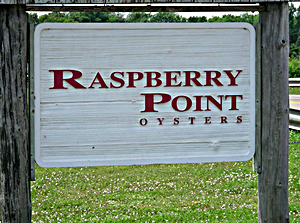
Tammy, our tour guide, told us about the infamous Raspberry Point Oysters. In the pristine spot, on the north shore of PEI is Prince Edward Island National Park and that’s where Raspberry Points grow in off-bottom cages. Keeping them off the bottom gives them lighter flavor and nicely manicured shells. But it’s cold up there at the northern tip of the oyster’s world, so Raspberry Points take a whopping six to seven years to reach their standard 3 1/4-inch size. Raspberry Points are consistently good—salty like a Malpeque, but always nicely rounded and substantial. After a novice oyster eater has enjoyed some Beausoleils, then try a Raspberry Point. They will provide a bigger mouthful, more crunch, lots of salt, and they goes down so easy.

Green Gables National Heritage Site, located in Cavendish, is a popular tourist destination. Each year hundreds of thousands of visitors from around the world visit the site which inspired the setting for L.M. Montgomery to create her beloved tale of a red-haired orphan, Anne of Green Gables. In addition to the Green Gables House, several museums and sites invite visitors to learn more about Anne and Montgomery and a popular musical version of the story runs every summer at the Charlottetown Festival.


The site highlights the heritage of the area and portrays Lucy Maud Montgomery's role as an author of national historical significance. And of course, we visited the house, took a stroll on the Haunted Woods and Balsam Hollow trails, enjoyed ice cream and purchased items from the gift shop! The rooms in the house were reconstructed to take on the themes from the novel.


Before an orphaned red-head even popped into her mind, Lucy Maud Montgomery fell in love with Prince Edward Island and its glorious coast. PEI is the perfect back-drop for Montgomery’s novel that warmed the hearts of readers around the world. The town of Avondale is based on real-life Cavendish. Montgomery grew up in Cavendish and believed that it is the most magical place on earth. Many of the scenes in the novel off of real life locations in PEI.


Strongly connected to its proud fishing tradition, North Rustico residents pride themselves on their closeness to both land and sea. We stopped at the wharf's in North Rustico and saw an Osprey nest, watched a deep sea fishing charter clean their catch and feed the gulls. We also got information on how the lobster traps work and were able to see a boat that was still decorated from the Canada’s Day 150.


We enjoyed our lunch at the world-famous Fisherman`s Wharf Lobster Suppers in North Rustico (known as "The Crick" by locals.) We enjoyed the 60 foot salad bar, All-You-Can-Eat Mussels, Seafood Chowder and unlimited desserts!


We returned from our bus tour and just relaxed in the afternoon, visiting with our new friends and let the dogs play together one last time, before the caravan breaks up! Bailey was a rescue dog and she was so scared when the caravan started ... boy, she sure is much better socialized now! She is the beagle jack russell in the pink harness.


We carpooled together to see Anne of Green Gables, the musical in Charlottetown at Confederation Center of the Arts. It was an awesome show and a spectacular end to an excellent adventure!

Wednesday, July 12, 2017

Day 28 of 30 on our 2017 Canadian Maritime Caravan with Yankee RV Tour

On Sunday July 2, 2017, we made our last move as a Yankee RV Caravan group. Naturally, Mother Nature wanted us to remember this trip and she gave us rain! We departed Woodhaven Campground, let me tell you a bit about this awesome campground. It is situated on seventy acres of wooded and open land within the Halifax City limits. Our sites we open with some trees diving the sites. All the sites were back to back, so the first RV pulled in and the second RV backed in to the same long crushed stone pad.

We traveled east on Route 213 E to Larry Uteck Blvd. Larry Uteck was a Canadian professional football athlete, university sports administrator, football coach, and municipal politician. Following university, he played with the Toronto Argonauts, BC Lions, Ottawa Rough Riders, and Montreal Alouettes in the Canadian Football League and was named Conference All-Star three times. He became the Head Football Coach of the Saint Mary's Huskies in 1983 and continued through 1997. He was named AUAA Coach of the Year 5 times. He was named CIAU Coach of the Year twice. His teams appeared in five Atlantic Bowls and three Vanier Cups. In 1995, he was named interim Director of Athletics and Recreation and was formally appointed Director in 1997, a position in which he continued until his death, in 2002. Uteck also worked for the larger Halifax community, notably as Deputy Mayor of the Halifax Regional Municipality.


Kearney Lake Road to 102 N. On Kearney Lake Road, you run along Kearney Lake. It is a nice recreation area for kayakers and swimmers. Kearney Lake is also home to the Maskwa Aquatic Club.

Atlantic Canada Aviation Museum is located close to the Halifax Airport. It all started in 1977 when a group of volunteers got together to set-up the only museum devoted to preserving all aspects of Atlantic Canada’s aviation heritage. In 1985 the doors were first opened to the public and in 1989 the Museum was granted ‘Local Museum’ status by the Nova Scotia Museum. Throughout the Museum and the extensive displays both civilian and military aviation history is depicted. Included are hundreds of artifacts, large and small, from books, badges and uniforms to engines and aircraft from the earliest balloons and gliders through to modern aircraft. Each one is designed to be information and tell its own part in the story of Atlantic Canada’s aviation history. Atlantic Canada has a rich aviation heritage, beginning with the first powered flight in Canada and the British Empire in 1909. However, it is a heritage that, until the formation of the Atlantic Canada Aviation Museum and our sister organizations at Shearwater and Greenwood, was largely forgotten. Over the next ten years from 1986 to 1995, the Museum continued to grow, and along with it the visions of all the volunteers working at the Museum for how they saw the future unfolding. From 1995 to present day the Museum and its team of volunteers has continued to thrive and grow. Each and every year there are more new displays on view and upgrades being made, keeping things fresh and modern is just as much a key part of the Museum’s role as it is telling its historic story.


We crossed over the Stewiacke River as the tide was coming in. It is a river in the Canadian province of Nova Scotia that starts at Dryden Lake in Pictou County and flows into the Shubenacadie River running through the Stewiacke Valley. It is part of the Bay of Fundy, hence the reddish brown color!


We traveled on Route 104, again but this time heading west. We did finally see some blue skies! Route 104 takes you past the Cobequid Interpretive Center and part of the road is called the Cobequid Pass. The name Cobequid was derived from the Mi'kmaq word "Wagobagitk" meaning "the bay runs far up", in reference to the area surrounding the easternmost inlet of the Minas Basin, a body of water called Cobequid Bay. Cobequid was granted in 1689 to Mathieu Martin. He was said to be the first Acadian born in Acadia. In 1705, the Acadians first settled in this area near Cobequid Bay. The Acadian culture consisted primarily of farming. Their advanced farming systems of dykes, permitted them to recuperate valuable farmland from the marshlands that cover the entire coast of the community. The community, which is now called Masstown, is located 10 minutes west of Truro. In 1714 many inhabitants of Minas, signed to a resolution, dated 9 September 1714, to go to Cape Breton. The Cobequid Acadians were close to an Indian mission located where the Stewiacke meets the Shubenacadie; and which had been run, for many years, by Le Loutre. In January 1750, Le Loutre made an ever closer alliance with his native friends (the sworn allies of the French crown). This meant that the Acadians of Cobequid did not want to get too friendly with the English. On the second day of September, 1755, the French inhabitants of Cobequid Village, lying on the north side of the bay, were working in their fields because it was harvest time. Three British vessels came into the Bay. 

Two of them anchored, one opposite the Village, and the other at Lower Cobequid; while the third went further up the shore. On September 4, they placed a notice on the church, that read that all their belonging now belong to His Majesty. However, this order had been given by William Shirley, Governor of Massachusetts and commander-in-chief of North American forces, and not by the British government in London. This was William Shirley's revenge for the death of his son during Edward Braddock campaign against the Canadians in the Ohio Valley. This was the beginning of the Acadian deportation.

We went from the rain, to seeing some blue skies to heavy fog! We are getting all kinds of weather today!

There is a new red trail bridge over the River Philip. The bridge is in Oxford. It is a friendly town with scenic beauty to behold and a history to be told along the old Rail bed to the River Philip. The trail through this area is 5 miles and the bridge connects Oxford with the trail system through the rest of Cumberland County as well as with Pictou and Halifax via the Sunrise Trail system. Eventually some historic sites will be identified with markers and information, picnic tables and benches along the way for rest stops will be put in so to enhance the trail experience.

We passed Joggins Fossil Center and Cliffs, which is another UNESCO World Heritage Site. This sight has been preserved in nature, uncovered by force. It is here that the highest tides in the world reveal the most complete fossil record of the “Coal Age,” 100 million years before the dinosaurs. Every rock holds the possibility of discovery, and our guided tours may lead you to finding a missing piece of time’s puzzle. The Joggins Fossil Centre is situated on the reclaimed site of the Old Joggins No. 7 Coal Mine overlooking the Joggins Fossil Cliffs. The Centre provides an exceptional learning experience, featuring an extensive fossil specimen collection, exhibits, and displays depicting

We had a rest stop at the Nova Scotia Welcome Center. This area was the site of the Acadian Village of Beaubassin, first known as Bourgeois Settlement. Raided in 1696 and again in 1703 by a force from Boston under Captain Ben Church. Occupied by French Troops in 1746, who traveled on snowshoes in February 1747 to make a surprise midnight attack a Grand Pre. In 1750 the entire village of 121 buildings, church, mill and tannery was burned by Indians under orders of Abbe La Loutre and the inhabitants forced to go to French Territory. The site, now is largely comprised of hayfields, pasture and marshland. A marker and this lonely cross are all that marks the spot.


We crossed the Nova Scotia and New Brunswick border without much fan fair, just some flags flying in the breeze.


We traveled east on Route 116, also known as Acadian Coastal Drive. This area is as renowned for its spirited Acadian culture as it is for its beautiful destinations. The Acadian coastal Drive is a total of 466 miles. Port Elgin is conveniently located at the intersections of Highway 15 and 16, and Provincial Route 970, just minutes from the Confederation Bridge to Prince Edward Island and the border of Nova Scotia. The historic, picturesque village of Port Elgin, New Brunswick, is on the Northumblerland Strait near Fort Gaspereaux National Historic Site. From the summer encampment of the Mi’kmaq on the banks of the Gaspereau River to the arrival of the Acadians and the building of Fort Gaspareaux, and from the building of the Intercolonial Railroad and the construction of the Trans Canada, Port Elgin has been at the crossroads of commerce.


We saw more “Watch for Moose Signs” on our way to the Confederation Bridge. They have "moose" whistles on the edge of the bridge, to keep the moose off the bridge.


We crossed the Confederation Bridge. The Confederation Bridge joins the eastern Canadian provinces of Prince Edward Island and New Brunswick, making travel throughout the Maritimes easy and convenient. The curved, 8 mile long bridge is the longest in the world crossing ice-covered water, and continues to endure as one of Canada’s top engineering achievements of the 20th century. The decision to replace the existing ferry service with a fixed link followed a heated debate throughout the 1980’s. Farmers, fishermen, tourism operators, and residents of Prince Edward Island had sharply contrasting opinions about how year-round access to the mainland would affect their way of life and livelihood. Eventually, it was decided that the debate would be settled at the polls. The federal department of Public Works and Government Services selected its favorite bridge design out of several proposals from the private sector, and on January 18, 1988, Premier Joseph Ghiz asked Prince Edward Islanders to make the final decision in a vote. At the polls, 59.4% of Islanders voted “Yes” to a fixed link. After four years of construction using crews of more than five thousand local workers, the Confederation Bridge opened to traffic on May 31, 1997.

There is a live bridge cam on the eastbound side of the bridge, into Prince Edward Island. We prepared our friends and family to watch us cross the bridge on their phones, computers or tablets by giving them advance notice. We had to change the time by an hour, due to travel delays. But, I think many of them were ready! We wanted to be sure that they could see us … we put a sign in the passenger side of the front window. The New Brunswick and Prince Edward Island border is the Northumberland Strait.


As we drove further into PEI, Rod narrated the fact that there are no rivers in PEI, only estuaries. The sea water flows in and out.


PEI also has many farms, most of them are potato farms.


We arrived at Cornwall KOA, our home for the next two nights. We had time to relax and tend to personal matters.


We were treated to music by the Vagabond Minstrel, Gordon Belsher. He has been a friend of Rod’s for more than 25 years! He is based in Prince Edward Island on Canada's east coast. Gordon Belsher has been entertaining audiences in Canada and around the world for more than 40 years performing at concerts, ceilidhs, conventions, and pubs. He played classic PEI tunes, some John Denver and introduced us to the Mandola & Bahran, a drum. After our private ceilidh with Gordon, we enjoyed a pizza party provided by Yankee RV Tours.