Thursday, June 10, 2021

June 3rd, 4th and 5th, 2021 … Summer of Fun continues!

We moved the Lazybrook Park for the 14th annual NEPA Bluegrass Festival. Every June, dozens of traditional and progressive bluegrass bands take the stage at the NEPA Bluegrass Festival in Tunkhannock, PA. This three-day event included food and craft vendors, workshops, and tons of bluegrass on two stages. We had the perfect campsite halfway between both stages and across from the jam tent.

The looming presence at Lazybrook Park is the big red bridge! This eight panel structure was built by the Corrugated Metal Company. This company was known for bridges such as the Pierceville Bridge, a patented type of truss known today as the lenticular truss. These bridges feature a beautiful and distinctive shape to them that is unique enough that they can be considered among the rarest types of bridges remaining in the country. The preservation of each surviving lenticular truss bridge is absolutely essential. Having been built by the Corrugated Metal Company, this is among the earliest examples of a lenticular through truss. It is also remarkably complete, with very few alterations. This is also one of the only bridges where the Historic Bridge Inventory itself strongly advocates for the preservation of the bridge. In June, 2015, a project to relocate and restore this historic bridge to nearby Lazybrook Park for non-motorized traffic began. As of summer 2018 the project is complete and the bridge is open. The preservation of the Pierceville Bridge is truly a historic moment for Pennsylvania. The Pierceville Bridge preservation project was an in-kind restoration of the bridge, the first of its kind in Pennsylvania. 

The jam tent has impromptu music from about 11am until close to 1am! Oh, it was so great! Our friend, Jay Busch, led a few of the jam sessions. They play like a true jam circle. They go around the tent and each person leads the group in a song. No one is left out, unless they choose to pass, and everyone can join in.

Some of the entertainers we saw included, the Baker Family. The Baker Family was on season 12 of America’s Got Talent. They are a high energy bluegrass band located in south central Missouri. They travel throughout the US. The band members include, Carrie Baker (the mother) plays guitar and upright bass; Trustin Baker (22 years old) playing Fiddle, Banjo, and lead vocals; Carina Baker (19 years old) playing mandolin, lead vocals, and harmony; Elijah Baker (17 years old) plays lead guitar and upright bass.

Doyle Lawson is an American traditional bluegrass and Southern gospel musician. He is best known as a mandolin player, vocalist, producer, and leader of the 6-man group Doyle Lawson & Quicksilver. They are a great group, but times are changing as Doyle Lawson, a 43 year veteran leader of Doyle Lawson & Quicksilver, has announced that he will be stepping away from that role at the end of 2022. With nearly six decades as a professional bluegrass entertainer under his belt, Lawson is clearly the reigning senior statesman in our music. Still active as a touring artist, he plays regularly at festivals. He started on banjo with Jimmy Martin in 1963, who he had known back home in Sneedville, TN for several years. Years later he joined up with JD Crowe and The Kentucky Mountain Boys on guitar, but soon switched to mandolin. Doyle was back to Jimmy’s band in ’69 for a short time, but returned to Crowe until ’71. That was when he joined Charlie Waller and The Country Gentlemen, the beginning of an epic eight year stint that saw him participate in several landmark recordings, none more so than 1972’s The Award Winning Country Gentlemen. In 1979, history was made with the debut of Doyle Lawson & Quicksilver.

On the Progressive Stage we heard Mama Corn. One of the Keystone state’s hottest bluegrass bands.  Evident at those early sessions was an undeniable chemistry between several of us who shared a love for old time Appalachian folk and bluegrass music, so the idea of building a band was discussed. This quartet has become a mainstay on the regional bluegrass festival circuit.  Featuring multi-talented singer-songwriters; utilizing guitar, banjo, dobro, harmonica, mandolin, upright bass and remarkable vocal harmonies, the spirit of traditional roots music is echoed in their sets.  After the formal line up was set, they started rehearsing as a band at the famous "Bait Shop" rehearsal studios in early 2007, and "Mama Corn" was born.  Right from the first rehearsals there was a lot of potential and they knew they had something special.  Their first showcase was at a local watering hole called "The Hitching Post" where the owner was a bluegrass enthusiast. Their self-titled album, "Mama Corn", was completed in June of 2011 and was met with good reviews.  They have played venues including The Rochester International Jazz Festival.

One of the main reasons we decided to come to the NEPA festival was the Malpass Brothers. As young boys, Christopher and Taylor Malpass soaked up the music of their granddad’s phonograph records. Christopher earned his first talent show trophy at age 7, and Taylor was playing mandolin by the time he was 10. Today, they promote the work and music of classic country artists they treasure while creating new music and making their own mark in the lineage of a rich American cultural heritage. With sincerity, honesty and an utter ease on stage that belies their years, their smooth vocal blend and skillful musicianship layer infectiously into the deep respect they pay to legends who have paved the way. Add the funny, off-the-cuff quips between the two 20-something siblings, and the engaging concert becomes a magnetic time-traveling journey to when a calmer rhythm reigned supreme. The Malpass Brothers toured with the late Don Helms, former steel guitarist for Hank Williams, have opened for music legend Merle Haggard on multiple tours and appeared on stages from the Shetland Islands to Ryman Auditorium to Merlefest. Their most recent self-titled recording, produced by bluegrass legend Doyle Lawson, was released by Crossroads’ Organic Records in 2015.

We made a side trip to the Tunkhannock Creek Viaduct or the Nicholson Bridge. Among the greatest bridges in the world is the famous Tunkhannock Viaduct, which has been called the 9th Wonder of the World. It is just passing a century old milestone, the Tunkhannock Viaduct still creates an impressive sight in northeastern Pennsylvania. It took three years to build, the massive reinforced concrete bridge that stretches out almost a half mile. Its graceful central arches are supported by piers that were sunk 138 feet below ground level.

To complete the bridge, the contracting firm of Flickwir and Bush employed a workforce of about 500 men, some of whom worked nearly 300 feet off the ground on and around temporary construction towers and cables. In the course of work, two men fell to their deaths. Soaring high above the valley floor, Tunkhannock Viaduct stretched for 2,375 feet across ten 180 foot arches and two 100 foot arches. It consumed 167,000 cubic yards of concrete (about 350,000 tons) and 1,140 tons of reinforcing steel. When completed in 1915, it was twice as long and more than twice as high as the 1848 stone-arch Starrucca Viaduct, which lies about twenty-five miles northeast of Nicholson.

This amazing structure, rising 240 feet above the creek bed, was built by the Delaware, Lackawanna, and Western Railroad. A key link in the railway, the project was designed to straighten out existing curves and steep grades of the previous tracks where trains often struggled through these rugged Pennsylvania hills. Considered a marvel in engineering at the start of the 20th century, the bridge shaved more than an hour from a freight train's schedule.

This majestic bridge is still in use today by the Canadian Pacific and Norfolk Southern Railroad. Also called the Nicholson Bridge, the viaduct looms over the small Nicholson Township. 


Difficult to escape its presence, Nicholson celebrates Bridge Day every September.


Stay tuned to follow the next stops on our #TwoLaneAdventures

Monday, June 7, 2021

June 2nd, 2021 … Summer of Fun continues!

Today we wanted a good breakfast out. The campground host suggested a restaurant in Hillsgrove. We drove thru Hillsgrove twice, then stopped at a package store in town asking where the resturaunt was in town. He said inside the McCarty Mercantile.  Inside we discovered the Tannery Café. The former Hillsgrove Country Store is under new management!  Cindi McCarty and Robert Bundle are now running this wonderful hometown classic.  Cindi will be offering many grocery items, daily specials, her amazing macaroni and potato salads! We came for breakfast, and were not disappointed!


Breakfast was delicious, Charlie had the Pancakes and I had "The Mess." I was not as daring as some ... I had the mess with bacon, a true Pennsylvanian would have had it with Scrapple! Scrapple, isn't that a game? Not in these parts ... 
Scrapple, also known by the Pennsylvania Dutch name Pannhaas or "pan rabbit", is traditionally a mush of pork scraps and trimmings combined with cornmeal and wheat flour, often buckwheat flour, and spices. The mush is formed into a semi-solid congealed loaf, and slices of the scrapple are then pan-fried before serving.


We needed a post office and lucky for us, the mercantile had a post office inside the store just beyond the café. Also lucky for us, they had a signal booster and we were able to check our emails too!


With the lack of cell signal and over the air TV channels I can understand why we keep seeing these long forgotten phone booths! They need them in this area!

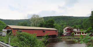
After breakfast, we took a Sunday drive on a Wednesday and toured several covered bridges in the area. The first was less than a mile from our breakfast stop. Located on Covered Bridge Road over Loyalsock Creek in Sullivan County is Hillsgrove Covered Bridge #38-57-02. It is also called Rinkers Covered Bridge. It was built in 1850 by Sadler Rogers in the Covered Burr arch-truss style. It was rehabilitated in 1963. The length of largest span is almost 172 feet with the total length of the bridge at 186 feet.

You would not want to come upon this bridge too fast after dark, there is a sharp right turn to enter the bridge. The decking was listed as “fair” in 2017 and from the steady thump, thump, thump as you cross the bridge I think “fair” may be a generous rating. But statistics from 2017 say 54 cars cross the bridge on a daily basis. I am not sure why, because you can access PA-87 from both ends of the bridge. On July 2nd, 1973 the bridge was added to the National Register of Historic Places.

Little has changed over the past 170 years at this river location where the Forksville General Store and the Forksville Covered Bridge spans the Loyalsock Creek. The town’s general store and bridge both date back to the early 1850s and remain historic focal points of this Pennsylvania village. Loyalsock Creek was always a natural roadblock for the growing town. So young Sadler Rogers, just a8 at the time, was called upon to reconstruct the Forksville Covered Bridge. The 152 foot span features a row of distinct horizontal windows, lighting the way for pedestrian walkways on each side. Traveling west on Route 154, and heading to the Forksville General Store, you’ll have to enjoy a bridge crossing in order to sample the restaurant’s marvelous meals.


The third bridge in the area built by Sadler Rogers is the Sonestown Covered Bridge. It is located just off Route 220 near the turn off to Eagles Mere.


Once again, we were able to see some more Pennsylvania natives, the four-legged variety. This one was not bothered by our being so close in a car!


On our way home, we stopped at the Chapel and took a short walk on the Double Run Nature Trail.

It was a 1.2-mile loop with more difficult hiking with short, steep sections. This trail begins and ends on PA 154 across from the park chapel. It travels through rich, fertile woodlands along the west branch of Double Run. Solomon seal, wild ginger, jack-in-the-pulpit, and other spring, ephemeral wildflowers grow abundantly along this trail, which has waterfalls and pools. 

If it was warmer, I might have considered checking out this perfect swimming hole, but not what is under that ledge!

We have spent our days traversing Loyalsock Creek, which flows about 60 miles. It begins in Wyoming County and flows through Sullivan and Lycoming counties in the central part of the state. Deep pools, fast flowing water and late spring temperatures are the key ingredients for an excellent fishing experience. The Upper Loyalstock, above Forksville, is known for its fast moving currents and a bolder strewn river bed. 

A mile and a half section of the river in Lycoming County is designated as Loyalsock Angler - Sullivan County, Pennsylvaniaa Delayed Harvest Artificial Lures Only section. Here, mayflies and caddis sometimes cover the Loyalstock. Mimicking these natural baits increase an angler's chances of success. Unfortunately, Pennsylvania receives more acid rain than any other section of the country. Acidic water adds additional stress to plants and animals. The river bed, primarily made up of sandstone, limestone and shale, has little effect neutralizing acid waters.

Rain was going to set in for our last night in Worlds End State Park, but it has been a great five-day 

#TwoLaneAdventures here, we will be back! Check back tomorrow to see where we are!

Sunday, June 6, 2021

June 1st, 2021 … Summer of Fun continues!

Ricketts Glen State Park harbors the Glens Natural Area, a National Landmark. The large park is comprised of over 13,000 acres in Luzerne, Sullivan and Columbia counties. The history of Ricketts Glen State Park can be traced to the American Civil War. At the outbreak of the Civil War in 1861, Robert Bruce Ricketts enlisted as a private in the US Army. Fighting for the Grand Army of the Potomac, Ricketts led Battery F during the Battle of Gettysburg. Ricketts swiftly moved up the ranks. When the war ended, he was discharges a colonel.

In 1868, Colonel R Bruce Ricketts bought land in northeast Pennsylvania to timber it. Fisherman exploring the lower reaches of Kitchen Creek discovered waterfalls. Exploration revealed that two branches of Kitchen Creek cut deep gorges in a series of waterfalls, then united at Waters Meet and flowed through a glen among giant pines, hemlock and oaks. Colonel Ricketts built trails to the area of the waterfalls, which came known as the Glens Natural Area.

A member of the Wyoming Historical Society and Geological Society, Colonel Ricketts named many of the waterfalls after American Indian Tribes. HE also names waterfalls for his friends and family. The lower glen came to be called Ricketts Glen. Many of the magnificent trees in this area are over 300-years old. Diameters of almost four feet are common and many trees tower over 100-feet in height. Southern and Northern hardwoods meet here, creating an extensive variety of trees.


The Glens became a registered National Natural Landmark in 1969. In 1993, it became a State Park Natural Area and will be protected and maintained in a natural state.


Colonel Ricketts at one time owned or controlled over 80,000 of land in this area. His heirs, through the Central Pen Lumber Company, sold 48,000 acres to the Pennsylvania Game Commission from 1920-24. This left over 12,000 acres surrounding Ganoga Lake, Lake Jean and the Glens Area. Although the area was approved as a national park site in 1930s, World War II brought an end to this plan for development. In 1942, the heirs sold 1,261 acres, the Falls and Glen Areas, to the Commonwealth of Pennsylvania for a state park.

Additional purchases from Colonel Ricketts’ son, William Ricketts, in 1943 and 1949, resulted in the park consisting of 10,000 acrea. Purchases from other individuals have brought the park to its present size. Recreational facilities first opened in 1944. In 1950, the former Department of Forests and Waters replaced the Lake Jean Dam with a larger earthen dam. This combined Lake Jean and Mud Pond, creating the current 245-acre lake.


Ricketts Glen State Park is as close to a Waterfall Mecca as it gets within the United States. Within the confines of the park are 24 named waterfalls and dozens of small scenic cascades in between, all but one of which can be seen via a relatively easy hike in one day. All of the waterfalls occur within the Kitchen Creek drainage, split roughly in half between two branches of the stream which originate in different lakes and marshes on the plateau above the glens, and 5 of the falls found downstream of the confluence of the two branches.

We took the Falls Trail. There are twenty-one waterfalls along this trail system. The full loop of this trial is 7.2 miles. To see most of the waterfalls a 3.2 mile loop can be taken by joining a few other trails. The trails follow along 21 beautiful waterfalls ranging in height from 11-feet to 94-feet. The trail winds through the Glens Natural Area via a series of steep rock staircases and packed dirt paths. The scenery is well worth the effort, but we had to be very careful. The terrain is rocky, slippery and descends quickly. We decided to only go part way down and see a few waterfalls.

Mohawk Falls is the first waterfall along the Ganoga Glen branch of Kitchen Creek. The falls plunge over an initial undercut ledge, and then spread outward across a broad shelf and cascade down across a wide expanse of bedrock with a small island of trees growing in the middle of the cascades. The falls cascade away from the trail. Park literature cites Mohawk Falls as dropping 37 feet.


Oneida Falls is the second waterfall we came to along the Ganoga Glen branch. The falls plunge a clean 15 feet over a heavily undercut ledge, and stretch out across an expanse of streambed perhaps 25 feet wide, if not a bit more.


The Cayuga Falls is the third waterfall along this branch of Kitchen Creek. The falls drop just over 13 feet, making it one of the two smallest waterfalls in Ricketts Glen State Park. The falls drop in side-by-side segments with one half plunging over a nearly sheer part of the ledge, and the other half stepping down two or three separate ledges and partially cascading among boulders which have broken off from the adjacent cliff face.


The most spectacular is Ganoga Falls, at 94 feet. We stood near the base of Gonoga Falls and gazed up in wonder at the power of nature as they feel the cool misty breeze coming off the falling water. It is the fourth waterfall, as well as the tallest waterfall in Ricketts Glen State Park, and probably one of the top five tallest waterfalls in the state of Pennsylvania. The falls drop in two distinct steps, first tumbling down a stairstep ledge, veiling outward as it falls, and then after a very quick pause on a shelf, plunging in a broad curtain form over the second half of its descent.

The drainage area for the Ganoga Glen branch of Kitchen Creek covers about 4 square miles upstream of Mohawk Falls at the top of Ganoga Glen, and includes several lakes and areas of marsh which retain ground water well even in dry periods. Though the basin is of moderate size, the volume of water in the creek can vary substantially as the seasons progress, or as severe weather moves through. In general the streamflow will be at its lowest from late July through the end of September, but water will be present year round.


After we enjoyed these four falls, we had to turn around and take the same trek back to the parking lot. Maybe another time we can come back and do the whole loop!

On our way home, we saw a huge complex. The sign indicated it was Red Rock Job Corps. Job Corps is the nation’s largest federally funded vocationally focused education and training program for economically disadvantaged youths. Job Corps was established by the Economic Opportunity Act of 1964 and currently operates under the provisions of the Workforce Investment Act of 1998. Job Corps delivers intensive education (academic and general health) and training (vocational and social skills) to participants enrolled in its nationwide network of residential campuses. This training is delivered through a combination of classroom and practical hands-on experiences to prepare youths for stable, long-term, high-paying jobs. Training approaches and methods vary to allow for individualized instruction to meet the needs of each participant. The Red Rock Job Corps Center has been recognized as one of the top Job Corps centers in the nation. Red Rock Job Corps Center is a Job Corps training center in Colley Township, Sullivan County, Pennsylvania. Like all Job Corps centers, it provides vocational training and education at no cost to participants, who are 16 to 24 years old. 


The center opened in 1978 and uses the buildings of the former Benton Air Force Station, a Cold War radar facility which operated from 1951 to 1975. It is still the site of a Federal Aviation Administration (FAA) radar used for Wilkes-Barre/Scranton International Airport. 
In 1950, construction began on the 98-acre Benton Air Force Station, which was completed on September 21, 1951. In addition to the radar, there were barracks for airmen of the 648th Aircraft Control Squadron, based at Fort Indiantown Gap. In 1963 the Federal Aviation Administration began jointly operating the radar facilities. The Benton Air Force Station closed in 1975, though the FAA continued to operate the radar as an auxiliary service for the nearby Wilkes-Barre/Scranton International Airport. The remaining buildings and barracks were converted to the Red Rocks Job Corps Center, which opened in 1978.


We did see more wildlife along the side of the road!

Stay tuned for our next leg of our #TwoLaneAdventures


May 31st, 2021 … Summer of Fun continues!

The name of the park we are staying at is swirled with controversy. A map from 1872 called the area Worlds End. An article from July 20, 1935 indicated that there was even a dispute as to the proper name of the area. Some people called it Worlds End, others Whirl’s Glen, and still others Whirls End. The first name arose from the topography of the place. Seven mountain ranges converge on the point and one does receive the sensation of being at the ultimate ends of the earth. The proponents of the second name base their claim upon the whirlpool in the Loyalsock Creek and the third name was probably a contraction of the other two. Since the whirlpool had largely disappeared, it was decided that the name Worlds End would be the most appropriate. 


Hence, the name Worlds End State Forest Park. During 1936, a letter campaign caused the park name to be changed to Whirls End. Another letter campaign forced the matter to be brought to the former State Geographic Board, who supervised the official naming of places. The name was changed back to Worlds End during 1943.

Worlds End State Park is in a narrow S-shaped valley of the Loyalsock Creek just south of Forksville, Sullivan County. It is in a picturesque corner of the Allegheny High Plateau known as the Sullivan Highlands, which is part of the Endless Mountains of Pennsylvania. There is a dam that creates a natural swimming hole at the park. Unfortunately, they are working on the dam and the swimming hole and "beach" are closed until sometime in July. But, we walked along the swimming hole and I bet when it is open, it is just packed!


The scenery is spectacular, especially the June mountain laurel. Instead of hiking, we drove to the Canyon Vista. It’s a spectacular view of the Loyalsock Creek gorge from here at an elevation of 1750 feet. Many wildflowers grow beneath the canopy of maturing ash, sugar maple, and black cherry trees.

Millions of years of erosion by Loyalsock Creek created the stunning scenery and gorge. About 350 million years ago, this part of Pennsylvania was on the coastline of a shallow sea that covered most of the interior of North America. High mountains to the east eroded, dumping vast amounts of clays, sands, and gravels on the coast, building up the sediment for about 100 million years. The great pressure of the sediments squeezed the sands, clays, and gravels into the shale, sandstone, and conglomerate rocks found in the park today.

Collisions with Europe and Africa folded and raised the rock of the park into a large, flat highland, which probably stood far higher than it does today. Millions of years of erosion have carved the highland into the ridges and valleys of today. Where you see a ridge, you will find hard rock. The valleys once held softer rock. Loyalsock Creek has flowed through the area for an unknown length of time, creating the rugged, serpentine valley of Worlds End State Park.

Loyalsock State Forest surrounds Worlds End State Park. It is named for Loyalsock Creek, Pennsylvania’s 2018 River of the Year, a scenic freestone stream that winds though the forest’s approximately 114,000 acres in Sullivan, Bradford and Lycoming counties. The predominantly hardwood forest is managed by DCNR’s Bureau of Forestry to ensure long-term health and productivity of this “working forest.” A commitment to the maintenance of the forest’s wild character making it a resource for recreation, water, plant and animal habitat, sustainable timber and above all, scenic beauty.


The extensive forest cover, hemlock valleys, and mountainous terrain provide ideal habitat for “big woods” wildlife. White-tailed deer, black bear, and wild turkey are regularly sighted. The patient observer may find bobcat, coyote, and river otter. 

 
More than 200 species of birds have been recorded. We only saw chipmunks, blue jays, a cardinal and chickadees.


We drove to Eagles Mere, which is a small community in the endless mountains region of northeastern Pennsylvania. There are 120 full time residents, but during the summer that number swells to over 3,000. Beginning around 1870, Eagles Mere evolved as the "East Hampton" of Philadelphia, morphing into a famous mountain resort, to become the summer playground for vacationers escaping the heat in such cities as Philadelphia, Baltimore and Harrisburg.


A number of large hotels surrounded the lake and provided seasonal retreats for thousands of visitors each year as did turn-of-the-century Victorian cottages. The town remains on the National Register of Historic Places. While the Inn is an original structure from the earliest time in Eagles Mere, many of the charming - and sometimes rambling - "cottages" remain as reminders of a refined past, sometimes referred to as, "The Town that Time Forgot."

Eagles Mere is a summer resort boasting the pristine 230 acre private lake. The kidney-shaped Eagles Mere Lake is about 3/4 mile long. It is a natural spring-fed lake with exceptionally clear water in the Allegheny Mountains at an elevation of 2100 feet. The village sits at the south end of the lake; there is a small beach at the north end. Just north of the beach is the neighborhood called Eagles Mere Park. This neighborhood developed out of a Chautauqua which lasted from 1897 to 1902. The twelve houses of the original Chautauqua are still extant and 42 similar houses were built before 1930.


To get access to a cell signal or wi-fi we had to venture 10 miles to Laporte. It is a borough in Sullivan County, Pennsylvania. The population is under 600, yet despite its small size, it is the county seat of Sullivan County. It is the smallest county seat in Pennsylvania by population and in 1969 was one of the two smallest in the US. It was a mountain resort, formerly a lumbering and tannery center, founded in 1847 and named for John Laporte, Surveyor General of Pennsylvania. Wide verandas front many of the houses. Among the deeds preserved in the courthouse here is one recorded in 1864, which transfers the ownership of a large tract of land on a mountain plateau four miles west of Laporte to 'Almighty God.' The plateau was once the site of the Celestia Community of Adventists, founded in 1853 by Peter Armstrong and his wife. A small group of Adventists, interested in Armstrong's plan for communalism in preparation for the expected coming of the Lord, maintained the experiment for several years. Forced by hardships and the dissatisfactions of other members to abandon it, Armstrong returned to Philadelphia, after deeding the property to the Lord. Eventually the land was taken over by the county for unpaid taxes. The Sullivan County Courthouse was added to the National Register of Historic Places in 1978.


I found the “Bridge on Rock Run” in my online surfing, before we got here. So, naturally, we had to find it. Turns out, it was a gravel and dirt road … that has been happening a great deal in PA! The bridge carries one lane of an unimproved road in a forested setting in the Wyoming State Forest. This bridge is a very rare surviving example of a bridge by the Horseheads Bridge Company. This simple design decision gives the bridge an attractive and unique appearance that immediately identifies the bridge as a product of its builder. The one span, 125' long, Pratt thru truss bridge was fabricated in 1897. It is supported on a concrete and stone. The bridge is historically and technologically significant based on its completeness, documentation, and distinctive detailing.


Rock Run Road is a popular hiking area with amazing natural beauty in the Loyalsock State Forest. Near the mid-point of the Road, you can head to Sones Pond, a tributary of the Little Loyalsock Creek. The hillside is filled with an assortment of waterfalls, cascades, grottos, and pools. Some of the falls are seasonal. None of the falls are over 10 feet tall, but it is a stream of remarkable beauty. Old grades on the east side of the stream help with access. There are about 6-7 falls or cascades of varying heights.


Tamarack Run Natural Area is a unique natural area located in the northeast portion of the Loyalsock State Forest and is comprised of two hundred and thirty-four acres near Sones Pond. Named for the tamarack tree, this boreal conifer wetland provides protection for the plants, amphibians, and reptiles that call this natural area home.

Check back tomorrow, to see where our #TwoLaneAdventures take us!