
Our
Wagonmaster asked “What is the attraction in Oatman?” Donkies? Burros?
Yes, that is one reason I want to go there! Plus, on the ride up, I found a burro crossing sign! Another one to add to my collection!

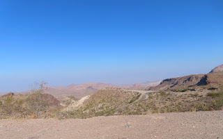
We found these guys on the road to Oatman, they have a long ways to go to make it into town! The road to
Oatman from Kingman is very narrow with several sharp hairpin curves. That was
one of the reasons we wanted to travel there from Kingman. It’s about 30 miles
closer from Needles, the road from there is not nearly as steep or sharp! We
saw many signs for “No vehicles over forty feet in length are allowed on this
road”.
The road to
Oatman from Kingman is very narrow with several sharp hairpin curves. That was
one of the reasons we wanted to travel there from Kingman. It’s about 30 miles
closer from Needles, the road from there is not nearly as steep or sharp! We
saw many signs for “No vehicles over forty feet in length are allowed on this
road”. 

The road is treacherous and there are not many modern rest stops. So, drive carefully and take advantage of the facilities when you find them! Oatman,
Arizona is a historic ghost town, where old buildings still stand and wild
burros roam the streets. No, seriously, watch out for them - they aren't afraid
of people, or cars. This once booming little town is nestled in the Black
Mountains of Mohave County. The town got its start as a mining camp after
prospectors struck gold in the area in the early 1900s. Later, it became part
of Route 66.
Oatman,
Arizona is a historic ghost town, where old buildings still stand and wild
burros roam the streets. No, seriously, watch out for them - they aren't afraid
of people, or cars. This once booming little town is nestled in the Black
Mountains of Mohave County. The town got its start as a mining camp after
prospectors struck gold in the area in the early 1900s. Later, it became part
of Route 66. Often
described as a ghost town, it doesn’t quite fit the category, but, close
enough, considering that it once boasted over 10,000 people and now supports
just a little over 100 people year-round. Though Oatman is only a shadow of its
former self, it is well worth a visit to this lively “ghost town” that
provides, not only a number of historic buildings and photograph opportunities
and the sights of burros walking the streets. We got there way too early! Not
many shops open, no burros, but most of the locals were friendly and helpful!
Often
described as a ghost town, it doesn’t quite fit the category, but, close
enough, considering that it once boasted over 10,000 people and now supports
just a little over 100 people year-round. Though Oatman is only a shadow of its
former self, it is well worth a visit to this lively “ghost town” that
provides, not only a number of historic buildings and photograph opportunities
and the sights of burros walking the streets. We got there way too early! Not
many shops open, no burros, but most of the locals were friendly and helpful! In its heyday,
from the early 1900s to the 1940s, Oatman and the nearby town of Gold Road were
the largest producers of gold in Arizona. Prospector Johnny Moss first mined
the area for Gold in the 1860s, staking claims to two mines, one named Moss,
the other Oatman, after Olive Oatman who was kidnapped by Apache warriors, sold
to Mojave Indians, and released after five years near the current town site in
1855. Gold mining would have its ups and downs in the Black Mountains until the
early 1900s.
In its heyday,
from the early 1900s to the 1940s, Oatman and the nearby town of Gold Road were
the largest producers of gold in Arizona. Prospector Johnny Moss first mined
the area for Gold in the 1860s, staking claims to two mines, one named Moss,
the other Oatman, after Olive Oatman who was kidnapped by Apache warriors, sold
to Mojave Indians, and released after five years near the current town site in
1855. Gold mining would have its ups and downs in the Black Mountains until the
early 1900s.  An official
town began to form around 1904, complete with a Post Office when the Vi-vian
Mining Company began operations. The tent city called Vivian quickly grew as
miners flocked to the area. Between 1904 and 1907 the mine yielded over
$3,000,000 and a large gold find at the Tom Reed Mine in 1908 brought in
$13,000,000. In 1909 the town changed its name in honor of Olive Oatman.
An official
town began to form around 1904, complete with a Post Office when the Vi-vian
Mining Company began operations. The tent city called Vivian quickly grew as
miners flocked to the area. Between 1904 and 1907 the mine yielded over
$3,000,000 and a large gold find at the Tom Reed Mine in 1908 brought in
$13,000,000. In 1909 the town changed its name in honor of Olive Oatman. The Drulin
Hotel, which was built in 1902, did a brisk business to the area miners. This
old hotel renamed the Oatman Hotel in the 1960s, is the only historic two-story
adobe building in Mohave County. Though guests no longer stay the night here,
there is a museum on the top floor and a bar and restaurant on the bottom floor.
Too bad, it was not open for us to tour while we were there.
The Drulin
Hotel, which was built in 1902, did a brisk business to the area miners. This
old hotel renamed the Oatman Hotel in the 1960s, is the only historic two-story
adobe building in Mohave County. Though guests no longer stay the night here,
there is a museum on the top floor and a bar and restaurant on the bottom floor.
Too bad, it was not open for us to tour while we were there.
When Route 66 was first built in the 1920s, several supporters worked to have the road parallel the railroad through Yucca, where its supporters lived. However, Oatman was at its peak as a mining community and had more clout. So, even though it made the drive more difficult on those old Model-T’s, the road took the hazardous journey up Sitgreaves Pass and bypassed Yucca. In 1921, a
fire burned much of Oatman, but the town was rebuilt. Just three years later
the main mining company, United Eastern Mines, shut down operations for good.
But with the birth of Route 66 and other smaller mining operations, Oatman
hanged on, catering to the many travelers along the new highway. By 1930, the
town boasted two banks, seven hotels, 20 saloons, and 10 stores. There was over
10,000 people living in Oatman “area”.
In 1921, a
fire burned much of Oatman, but the town was rebuilt. Just three years later
the main mining company, United Eastern Mines, shut down operations for good.
But with the birth of Route 66 and other smaller mining operations, Oatman
hanged on, catering to the many travelers along the new highway. By 1930, the
town boasted two banks, seven hotels, 20 saloons, and 10 stores. There was over
10,000 people living in Oatman “area”.  During the Second World War, the
government needed other metal types for the war effort, so the miners were
taken to other areas and the Oatman mines were closed, leaving the gold to wait
for better times.
During the Second World War, the
government needed other metal types for the war effort, so the miners were
taken to other areas and the Oatman mines were closed, leaving the gold to wait
for better times. In the late 1980s, Route 66 again became a popular destination
for tourists from all over the world.
Oatman started becoming very lively again. Then, in 1995 the Gold Road
mine was reopened, taking out 40,000 ounces of gold annually. In 1998, the mine
closed again because of low gold prices. It then provided gold mine tours for several
years; however more recently, with the current price of gold, the tours have
ceased as the mine has reopened once again.
In the late 1980s, Route 66 again became a popular destination
for tourists from all over the world.
Oatman started becoming very lively again. Then, in 1995 the Gold Road
mine was reopened, taking out 40,000 ounces of gold annually. In 1998, the mine
closed again because of low gold prices. It then provided gold mine tours for several
years; however more recently, with the current price of gold, the tours have
ceased as the mine has reopened once again.


Oatman is full of murals, just like every other town. But, there is little information on them. Most of them are caricatures of the town!

On our way back down from Oatman, we inspected the gate to nowhere. Yes, it is a unique alley way in the rock, which looks like it leads to nowhere! Someone, did take the time to tag the metal gate.
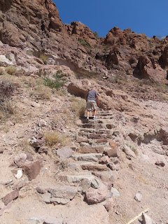
Speaking of going nowhere, we stopped at the rock staircase we saw on the way up the mountain. Yes, these steps lead to a few walking trails, but it is more fun to say they go nowhere … because a true rock climber, will not use the stairs!
We had hoped
to eat in Oatman, but that did not happen, so we headed back into Kingman and
we had a meal at Mr D’z Diner on Route 66. The exterior is a vibrant teal and
pink! It was once a small cafe and gas station in the 1950/60's. This Route 66
diner is an old fashioned diner, serving traditional diner fare, and is best
known for its homemade root beer! It was delicious! The diner is loaded with
Route 66 memorabilia and has served notable celebrities such as Oprah Winfrey,
and Angus T. Jones from Two and a Half Man. We enjoyed the atmosphere almost as
much as we did the food! The fact that it is on Route 66, makes this diner one
to remember.
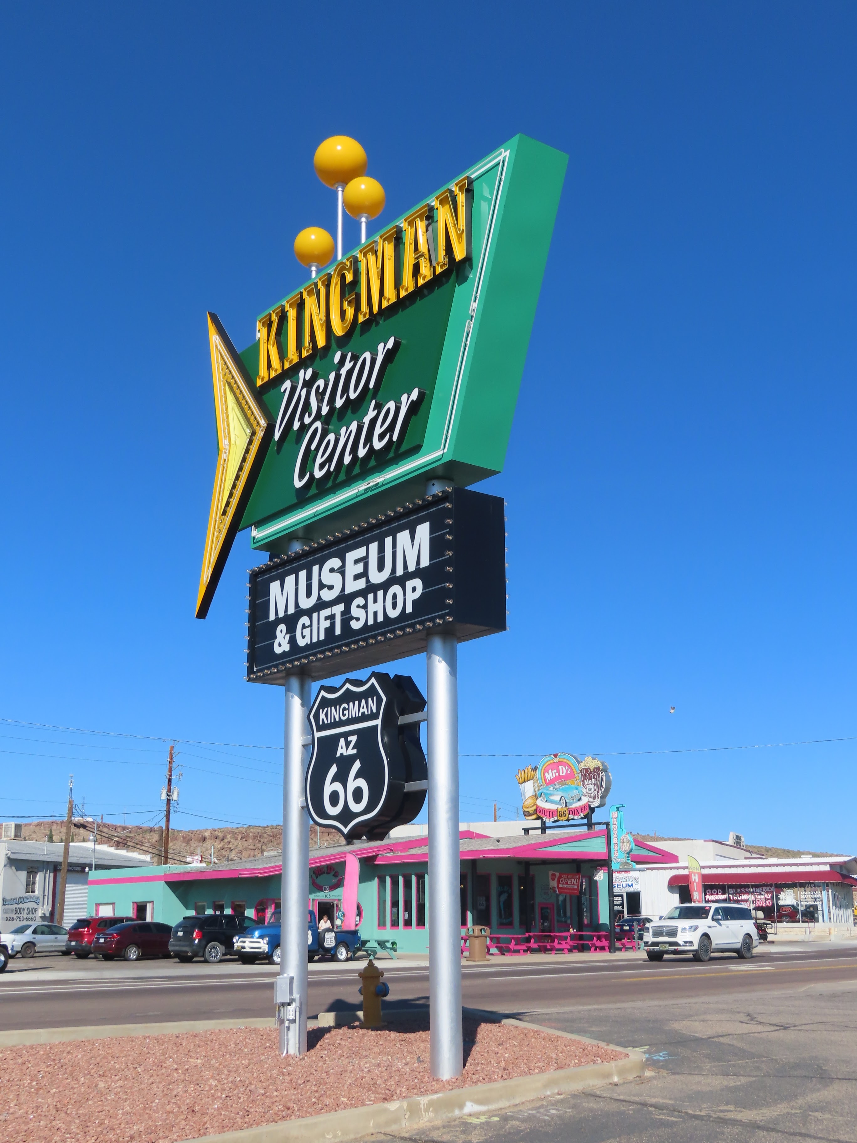
 After we
finished lunch, we toured around Kingman for a bit. The only town for miles in
any direction since its founding as a railroad center in 1882, Kingman has
always depended on passing travelers for its livelihood. Long a main stopping
place on Route 66, and still providing the only all-night services on US-93
between Las Vegas and Phoenix, and along I-40 between Flagstaff and Needles,
the town remains more a way station than a destination. The stretch of Route 66
through Kingman has been renamed in memory of favorite son Andy Devine, who was
born in Flagstaff in 1905 but grew up here, where his parents ran the Beale
Hotel. One of the best-known character actors of Hollywood’s classic era, the
raspy-voiced Devine usually played a devoted sidekick. His most famous role was
as the wagon driver in the classic 1939 John Ford western Stagecoach.
After we
finished lunch, we toured around Kingman for a bit. The only town for miles in
any direction since its founding as a railroad center in 1882, Kingman has
always depended on passing travelers for its livelihood. Long a main stopping
place on Route 66, and still providing the only all-night services on US-93
between Las Vegas and Phoenix, and along I-40 between Flagstaff and Needles,
the town remains more a way station than a destination. The stretch of Route 66
through Kingman has been renamed in memory of favorite son Andy Devine, who was
born in Flagstaff in 1905 but grew up here, where his parents ran the Beale
Hotel. One of the best-known character actors of Hollywood’s classic era, the
raspy-voiced Devine usually played a devoted sidekick. His most famous role was
as the wagon driver in the classic 1939 John Ford western Stagecoach.


Around Route 66 in Kingman are the most interesting murals. Some are Route 66 centric and others are more geared toward the business or the town.
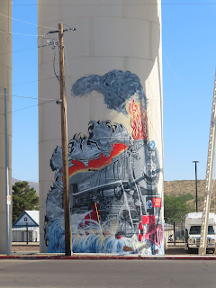
I hope you are not getting tired of murals, because I think that there is many more to come!

We found these guys on the road to Oatman, they have a long ways to go to make it into town!


The road is treacherous and there are not many modern rest stops. So, drive carefully and take advantage of the facilities when you find them!


When Route 66 was first built in the 1920s, several supporters worked to have the road parallel the railroad through Yucca, where its supporters lived. However, Oatman was at its peak as a mining community and had more clout. So, even though it made the drive more difficult on those old Model-T’s, the road took the hazardous journey up Sitgreaves Pass and bypassed Yucca.


Route 66 was changed to make an easier route south of the mountain passes in 1953. By this time, Oatman no longer held the clout that it had earlier when the Mother Road was first implemented. It didn’t take long for Oatman to be reduced practically to a ghost town.


Oatman is full of murals, just like every other town. But, there is little information on them. Most of them are caricatures of the town!

On our way back down from Oatman, we inspected the gate to nowhere. Yes, it is a unique alley way in the rock, which looks like it leads to nowhere! Someone, did take the time to tag the metal gate.

Speaking of going nowhere, we stopped at the rock staircase we saw on the way up the mountain. Yes, these steps lead to a few walking trails, but it is more fun to say they go nowhere … because a true rock climber, will not use the stairs!


Around Route 66 in Kingman are the most interesting murals. Some are Route 66 centric and others are more geared toward the business or the town.

I hope you are not getting tired of murals, because I think that there is many more to come!


