
On Monday June 26, 2017, we departed our overnight
stop at Scotia Pines. The sole purpose of our stop here was to see the tidal
bore … boy oh boy, was it worth it! The campground provided us all pull thru sites and exclusive use of the pavilion.
We got back onto Highway 102 West.

We passed through the Town of Stewiacke. In the
1900’s the chief of the Micmac’s at Millbrook said the native name for this
place was pronounced “Ah-seed-ee-a-waac” which means “place where the sands
move” which then slurred to “Stew-aack” then pronounced as we pronounce it
today. Waterways were the main means of travel for long distances or
transporting heavy loads until the late eighteenth century. For the ones who
traveled on foot, the Micmac trails followed the ways making detours to
important places. The trails were given a name “Green Road”. The Trail was due
north from where the present highways now crosses Main Street to the river. The
“Holesworth” house was built in 1839, which is the oldest standing house. Their most recent claim to fame is they are halfway between the equator and the north pole ... in theory, their weather should be perfect!

For the first time in our travels, we have
noticed lots of farms in Nova Scotia.

Today, we saw a hard working farmer and
his or her farm hands cutting and turning hay.

We caught a glimpse of a little bit of home today,
there were Osprey nests on the top of power poles.

East Hants has a roadway sign, but it is not really a tow. Officially named the Municipality of the
District of East Hants, is a
municipal district. With its administrative seat in Elmsdale, the district
municipality occupies the Minas Basin, sharing this boundary with the Municipality
of the District of West Hants. It was made in 1861 from the former townships of
Uniacke, Rawdon, Douglas, Walton, Shubenacadie and Maitland. Its most settled
area is in the Shubenacadie Valley.

I love to see old barns, this one was being used for advertising

The Shubenacadie Canal was originally surveyed by William
Owen in 1767 which lead to the proposal of the canal 30 years later. The
government of Nova Scotia commissioned Owen to follow the Shubenacadie waterway
from the Atlantic Ocean to Cobequid Bay.
 The Shubenacadie Canal was envisioned
to facilitate transportation between Halifax and the agricultural, timber and
coal producing areas of northern Nova Scotia and the Annapolis Valley.
Construction was started in 1826 by the Shubenacadie Canal Co. which went
bankrupt in 1831. Several Scottish and Irish stonemasons had immigrated to Nova
Scotia to work on the project but were left stranded in the colony with few
resources after the project had halted. Construction started again in 1854
under the Inland Navigation Company. The new company altered the original
British stonework lock designs to use more inexpensive North American stone and
wooden construction. Steam boats and barges began to use the canal in 1856 and
the entire system was completed by 1861. The canal enjoyed a few years of
healthy traffic especially during the Waverley gold rushes of the 1860s. However the canal company showed little profit and experienced many problems
relating to frigid winters which damaged the locks linking the freshwater
lakes. A final blow was a takeover by the Town of Dartmouth of the
Dartmouth Lakes for the city's water supply which ended canal operations in
1871.
The Shubenacadie Canal was envisioned
to facilitate transportation between Halifax and the agricultural, timber and
coal producing areas of northern Nova Scotia and the Annapolis Valley.
Construction was started in 1826 by the Shubenacadie Canal Co. which went
bankrupt in 1831. Several Scottish and Irish stonemasons had immigrated to Nova
Scotia to work on the project but were left stranded in the colony with few
resources after the project had halted. Construction started again in 1854
under the Inland Navigation Company. The new company altered the original
British stonework lock designs to use more inexpensive North American stone and
wooden construction. Steam boats and barges began to use the canal in 1856 and
the entire system was completed by 1861. The canal enjoyed a few years of
healthy traffic especially during the Waverley gold rushes of the 1860s. However the canal company showed little profit and experienced many problems
relating to frigid winters which damaged the locks linking the freshwater
lakes. A final blow was a takeover by the Town of Dartmouth of the
Dartmouth Lakes for the city's water supply which ended canal operations in
1871.


Hwy 103, Exit 5 is the Lighthouse Route. Traveling along the Lighthouse Route, can to get out and explore, seaside towns like Peggy’s Cove, Chester, Mahone Bay and Lunenburg! We will be visiting all of these charming towns. Notice the cute plaid at the bottom of the road sign. They are very proud of their heritage here!

We were on Highway 213, for a mile or so … then we turned onto St Margaret's Bay Road, Route 3. We skirted the bay as we meandered down the road.


We arrived at King Neptune Campground Campground, the first sights of the cove that would be our home for the next three nights was breathtaking!


Jackie and I had to climb down the rocks and put our toes in the water ... it was not tooooooooo cold!

We stopped at the Swiss Air 111 Memorial. It is located on Route 333 on the western side of the Preservation Area. On Sept. 2, 1998, anyone near the coast felt their homes tremble as the McDonnell Douglas MD-11 passenger plane, Swissair Flight 111, bound for Geneva, Switzerland crashed into the cold waters of the Atlantic Ocean, a few miles off the shore of Peggy’s Cove. All 229 people on board were killed.

 Though only four Canadians were killed on the flight, the crash of Swissair 111 had an enduring impact on Canada. The flight took off from JFK airport and then began to fly over the Atlantic Ocean, but a little less than an hour into the flight the crew noticed smoke and issued the international urgency signal.
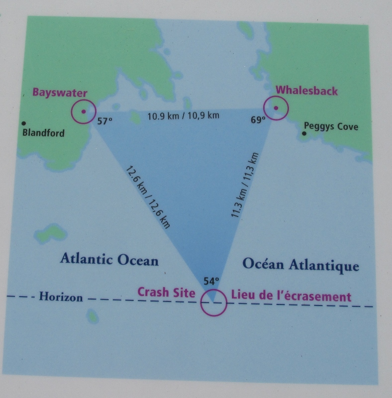 They were cleared to proceed to the airport in Halifax but crashed in the relatively shallow water. Remains of many who were aboard Swissair 111, are buried at a monument near Peggy’s Cove. The recovery effort retrieved 98 per cent of the aircraft which was then painstakingly pieced back together to aid in the official investigation of the crash. Lost cargo from the flight included currency, diamonds, jewelry and Pablo Picasso's The Painter. At the time, the painting's value was estimated at $1.5 million.


No comments:
Post a Comment