


Outside of Statesboro, we saw a small two story building with a sign “Georgia State Defense Headquarters.” Right away you think an early version of the Georgia National Guard. But you would be wrong. The Georgia State Defense Force (GSDF, GASDF, or SDF) is an unpaid, volunteer component of the Georgia Department of Defense. It serves in support of the national and state constitutions under direction of the governor and the adjutant general of Georgia. As a State Defense Force, members serve alongside the Georgia Army and Georgia Air National Guard. The mission of the GASDF is to provide an organized, trained, disciplined, rapid response volunteer force to


There are four historical markers along US 301, near the
intersection of 24 in Screven County. These markers are for John Abbot. Abbot
was a world famed entomologist and collector of Lepidoptera. He came to Georgia
from London in 1790, and settled in Jacksonboro, where he remained many years
collecting Lepidopterous insects. He was sent to Georgia by a London collector
and publisher. Besides being an assiduous collector, was an artist of some
note. Many volumes of his insects with the particulars
 of their habits, food
and metamorphoses were published in London. His books are the prized
possessions of many of the world’s leading Universities and Museums. He died
about 1840 and it is believed that his
unmarked grave is not many feet west of these markers.
of their habits, food
and metamorphoses were published in London. His books are the prized
possessions of many of the world’s leading Universities and Museums. He died
about 1840 and it is believed that his
unmarked grave is not many feet west of these markers.
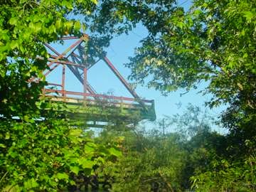
As we approached the GA/SC state line, which is at the top of a tall bridge that crosses the Savannah River we noticed a relic from the old highway's history: a rusty drawbridge. This wasn't any old drawbridge, though. Instead of raising and lowering, as most do, this one rotated out of the way. It had been turned to the open position and left that way for many decades. The approach to the old bridge drops off abruptly (it's blocked so
 that no one will
drive off the edge). Once you cross the bridge
and continue north, you might notice the old road running alongside the new one
for several miles. It's overgrown, and
it would be impossible to drive on it, but the raised road might make for an
interesting walking or fishing place.
that no one will
drive off the edge). Once you cross the bridge
and continue north, you might notice the old road running alongside the new one
for several miles. It's overgrown, and
it would be impossible to drive on it, but the raised road might make for an
interesting walking or fishing place.
Coming into Allendale SC we saw a sad marker of the days gone by, the times when these two lane roads were the main

 thoroughfare for
travelers heading north and south. Now, these places sit, vacant, dilapidated
and a sad reminder of better economic times. The Crescent Hotel is an abandoned
motel on 301 in rural Allendale, SC. It is almost across the road from another
empty hotel. I was lucky to find a picture of an old post card back when the
Crescent Motel as a thriving business to compare to the rusted old sign seen
today.
thoroughfare for
travelers heading north and south. Now, these places sit, vacant, dilapidated
and a sad reminder of better economic times. The Crescent Hotel is an abandoned
motel on 301 in rural Allendale, SC. It is almost across the road from another
empty hotel. I was lucky to find a picture of an old post card back when the
Crescent Motel as a thriving business to compare to the rusted old sign seen
today.
 Allendale SC is also home to the Carolina Theatre, which is
now part of the University of South Carolina, Salkehatchie campus. The Cooper
family once owned the historic theatre. I could not find any information on
when it stopped operating as a theatre, but it is interesting to see that the
original nostalgic façade is still there and as beautiful as ever. A far
contrast from the Crescent Motel.
Allendale SC is also home to the Carolina Theatre, which is
now part of the University of South Carolina, Salkehatchie campus. The Cooper
family once owned the historic theatre. I could not find any information on
when it stopped operating as a theatre, but it is interesting to see that the
original nostalgic façade is still there and as beautiful as ever. A far
contrast from the Crescent Motel.
 River Bridge State Historic Site was an important part of
the final months of the Civil War. 1,200 Confederate soldiers made a stand there
on the Salkehatchie River against Major General Sherman's sweep across South Carolina. Behind
stout, earthen fortifications, which are still intact today, the Southerners
fought a division of about 5,000 Union soldiers. Union troops crossed the
swollen swamp on both ends of the Confederate line to finally win the battle.
Today, Rivers Bridge is on the National Register of Historic Places and is the
only state historic site in South Carolina that preserves a Civil War
battlefield. The site also includes the Memorial Grounds. Here, slain
Confederate soldiers were interred and are remembered in memorial services that
have been held annually since 1876.
River Bridge State Historic Site was an important part of
the final months of the Civil War. 1,200 Confederate soldiers made a stand there
on the Salkehatchie River against Major General Sherman's sweep across South Carolina. Behind
stout, earthen fortifications, which are still intact today, the Southerners
fought a division of about 5,000 Union soldiers. Union troops crossed the
swollen swamp on both ends of the Confederate line to finally win the battle.
Today, Rivers Bridge is on the National Register of Historic Places and is the
only state historic site in South Carolina that preserves a Civil War
battlefield. The site also includes the Memorial Grounds. Here, slain
Confederate soldiers were interred and are remembered in memorial services that
have been held annually since 1876.
 In Bamberg, SC we transitioned off 301 North onto US Hwy 601
North. US Hwy 601 runs through St Matthews SC. This town is
bisected by a railroad cut. The cut through a small hill in the middle of St
Matthews has both helped to shape the town while also linking it forever with
it’s past. According to local history, the cut was excavated by hand by slaves
from local plantations. Soil was removed from the excavation sites with
homemade stick baskets, and the fills were completed in the same manner. Each
slave owner received twelve dollars per month, per slave; the railroad provided
the slaves with food and clothing. The Railroad cut looks today much like it did
when the first locomotive came through in 1841.
In Bamberg, SC we transitioned off 301 North onto US Hwy 601
North. US Hwy 601 runs through St Matthews SC. This town is
bisected by a railroad cut. The cut through a small hill in the middle of St
Matthews has both helped to shape the town while also linking it forever with
it’s past. According to local history, the cut was excavated by hand by slaves
from local plantations. Soil was removed from the excavation sites with
homemade stick baskets, and the fills were completed in the same manner. Each
slave owner received twelve dollars per month, per slave; the railroad provided
the slaves with food and clothing. The Railroad cut looks today much like it did
when the first locomotive came through in 1841.
 The town of St. Matthews was originally known as Lewisville.
Before becoming a town, Lewisville was a post office established some time
before the construction of the South Carolina Railroad (about 1840). The name
“Lewisville” had been chosen in honor of Colonel Lewis, a very prominent land
owner living in the area. After the arrival of the railroad, a town sprang up
and was chartered "Lewisville" by an Act of the General Assembly in
1872. However, the Act was never approved by the Governor and became law
without his approval. The spelling of the name "Lewisville" has long
been in dispute. A Mr. Louis opened a mercantile store near the present site of
the railroad depot. Many have confused the correct spelling of
"Lewisville," with his name. Lewisville finally became St. Matthews,
in honor of the old St. Matthew’s Parish, in March of 1876. When Calhoun County
was established, Mr. Robert Welch, attorney for the county, left the apostrophe
in “St. Matthew’s” out of the bill. Thus, the town name was officially “ St.
Matthews,” without the apostrophe.
The town of St. Matthews was originally known as Lewisville.
Before becoming a town, Lewisville was a post office established some time
before the construction of the South Carolina Railroad (about 1840). The name
“Lewisville” had been chosen in honor of Colonel Lewis, a very prominent land
owner living in the area. After the arrival of the railroad, a town sprang up
and was chartered "Lewisville" by an Act of the General Assembly in
1872. However, the Act was never approved by the Governor and became law
without his approval. The spelling of the name "Lewisville" has long
been in dispute. A Mr. Louis opened a mercantile store near the present site of
the railroad depot. Many have confused the correct spelling of
"Lewisville," with his name. Lewisville finally became St. Matthews,
in honor of the old St. Matthew’s Parish, in March of 1876. When Calhoun County
was established, Mr. Robert Welch, attorney for the county, left the apostrophe
in “St. Matthew’s” out of the bill. Thus, the town name was officially “ St.
Matthews,” without the apostrophe.
 Another reason we enjoy these two lane roads, where else can
you see a sign and make a detour to see the Forty Acre Rock's granite, as part
of the Flat Creek Preserve. The most prominent feature is the massive rock that
you can walk across and admire the scenery. It is named for a massive granite
standing rock that is actually closer to fourteen acres in visible size. The
rock is a celebrated example of a granite outcropping in the Piedmont, is one
of several exposures throughout the region. Many of the others, though, are
mined for their valuable high-quality granite, the state's official rock. Unfortunately,
vandals have defaced much of the main rock with spray-paint. However, it is
still an amazing sight!
Another reason we enjoy these two lane roads, where else can
you see a sign and make a detour to see the Forty Acre Rock's granite, as part
of the Flat Creek Preserve. The most prominent feature is the massive rock that
you can walk across and admire the scenery. It is named for a massive granite
standing rock that is actually closer to fourteen acres in visible size. The
rock is a celebrated example of a granite outcropping in the Piedmont, is one
of several exposures throughout the region. Many of the others, though, are
mined for their valuable high-quality granite, the state's official rock. Unfortunately,
vandals have defaced much of the main rock with spray-paint. However, it is
still an amazing sight!
 Downtown Pageland SC was a real treat in old town culture with a modern day twist. See the clock post and paint and flooring store in an old bank building. Nice wide and clean sidewalks with plants and planters.
Outside of Concord NC, there is a historic marker for Red Hill. The background to Red Hill involves President George Washington’s visit to North Carolina in 1791 as part of a larger tour of the southern United States to both observe the political climate and culture of the region but also to thank his supporters and instill a sense of unity in the new country. As such, his tour and stops along the way became important landmarks in the areas he touched. Proceeding from Mount Vernon via Fredericksburg and Richmond into North Carolina, Washington crossed the Roanoke River into Halifax in mid-April 1791. From there, the
 President’s carriage tour took him through Tarboro,
Greenville, New Bern, Trenton, and Wilmington before entering South Carolina.
Washington re-entered North Carolina near Charlotte and traveled northward,
visiting Red Hill, Salisbury, Salem, and Guilford Court House. Red Hill was
originally one of three plantations belonging to Martin Pheifer, Sr., a Swiss
immigrant who lived in Pennsylvania briefly before settling in North Carolina
before the Revolutionary War. Two of Pheifer’s sons, John and Martin Jr., both
lived at Red Hill at different points in their lives. Martin Pheifer, Jr. was a
good friend of George Washington’s, having served as an officer in the North
Carolina militia and with Washington at Valley Forge as part of a group of
light cavalry from the state. For that reason, Washington was a private guest
of Pheifer during his tour, dining and spending the night with the family.
Washington remarked in his journal of the trip that Pheifer was a good host and
that he provided well for his guests. Red Hill was destroyed during the first
half of the twentieth century but local historians state that the home featured
a tavern and inn in addition to serving as the home to several Pheifers.
President’s carriage tour took him through Tarboro,
Greenville, New Bern, Trenton, and Wilmington before entering South Carolina.
Washington re-entered North Carolina near Charlotte and traveled northward,
visiting Red Hill, Salisbury, Salem, and Guilford Court House. Red Hill was
originally one of three plantations belonging to Martin Pheifer, Sr., a Swiss
immigrant who lived in Pennsylvania briefly before settling in North Carolina
before the Revolutionary War. Two of Pheifer’s sons, John and Martin Jr., both
lived at Red Hill at different points in their lives. Martin Pheifer, Jr. was a
good friend of George Washington’s, having served as an officer in the North
Carolina militia and with Washington at Valley Forge as part of a group of
light cavalry from the state. For that reason, Washington was a private guest
of Pheifer during his tour, dining and spending the night with the family.
Washington remarked in his journal of the trip that Pheifer was a good host and
that he provided well for his guests. Red Hill was destroyed during the first
half of the twentieth century but local historians state that the home featured
a tavern and inn in addition to serving as the home to several Pheifers.
 We ended the day of traveling in Mocksville, NC which is the
largest municipality in Davie County and is the county seat. Mocksville is
strategically located in the western part of the Piedmont Triad. The Piedmont
Triad is a north-central region of the U.S. state of North Carolina that
consists of the area within and surrounding the three major cities of
Greensboro, Winston-Salem, and High Point. This close group or
"triad" of cities lies in the Piedmont geographical region of the
United States and forms the basis of the Greensboro-Winston-Salem-High Point
CSA. The metropolitan area is connected by Interstates 40, 85, 73, & 74 and is served by the Piedmont Triad International Airport. Long known as one of the primary
We ended the day of traveling in Mocksville, NC which is the
largest municipality in Davie County and is the county seat. Mocksville is
strategically located in the western part of the Piedmont Triad. The Piedmont
Triad is a north-central region of the U.S. state of North Carolina that
consists of the area within and surrounding the three major cities of
Greensboro, Winston-Salem, and High Point. This close group or
"triad" of cities lies in the Piedmont geographical region of the
United States and forms the basis of the Greensboro-Winston-Salem-High Point
CSA. The metropolitan area is connected by Interstates 40, 85, 73, & 74 and is served by the Piedmont Triad International Airport. Long known as one of the primary
 manufacturing and transportation hubs of the southeastern United States, the Triad is also an important educational and cultural region and occupies a prominent place in the history of the American Civil Rights Movement.
We are staying in Lake Myers, an Encore RV Resort … shhhh, don’t tell anyone … besides it was free … since Lazydays gave us 14 nights at Thousand Trails / Encore parks when we purchased the rig. Good night, another 300 miles covered today.

As we approached the GA/SC state line, which is at the top of a tall bridge that crosses the Savannah River we noticed a relic from the old highway's history: a rusty drawbridge. This wasn't any old drawbridge, though. Instead of raising and lowering, as most do, this one rotated out of the way. It had been turned to the open position and left that way for many decades. The approach to the old bridge drops off abruptly (it's blocked so
Coming into Allendale SC we saw a sad marker of the days gone by, the times when these two lane roads were the main

 thoroughfare for
travelers heading north and south. Now, these places sit, vacant, dilapidated
and a sad reminder of better economic times. The Crescent Hotel is an abandoned
motel on 301 in rural Allendale, SC. It is almost across the road from another
empty hotel. I was lucky to find a picture of an old post card back when the
Crescent Motel as a thriving business to compare to the rusted old sign seen
today.
thoroughfare for
travelers heading north and south. Now, these places sit, vacant, dilapidated
and a sad reminder of better economic times. The Crescent Hotel is an abandoned
motel on 301 in rural Allendale, SC. It is almost across the road from another
empty hotel. I was lucky to find a picture of an old post card back when the
Crescent Motel as a thriving business to compare to the rusted old sign seen
today. Allendale SC is also home to the Carolina Theatre, which is
now part of the University of South Carolina, Salkehatchie campus. The Cooper
family once owned the historic theatre. I could not find any information on
when it stopped operating as a theatre, but it is interesting to see that the
original nostalgic façade is still there and as beautiful as ever. A far
contrast from the Crescent Motel.
Allendale SC is also home to the Carolina Theatre, which is
now part of the University of South Carolina, Salkehatchie campus. The Cooper
family once owned the historic theatre. I could not find any information on
when it stopped operating as a theatre, but it is interesting to see that the
original nostalgic façade is still there and as beautiful as ever. A far
contrast from the Crescent Motel.

 The town of St. Matthews was originally known as Lewisville.
Before becoming a town, Lewisville was a post office established some time
before the construction of the South Carolina Railroad (about 1840). The name
“Lewisville” had been chosen in honor of Colonel Lewis, a very prominent land
owner living in the area. After the arrival of the railroad, a town sprang up
and was chartered "Lewisville" by an Act of the General Assembly in
1872. However, the Act was never approved by the Governor and became law
without his approval. The spelling of the name "Lewisville" has long
been in dispute. A Mr. Louis opened a mercantile store near the present site of
the railroad depot. Many have confused the correct spelling of
"Lewisville," with his name. Lewisville finally became St. Matthews,
in honor of the old St. Matthew’s Parish, in March of 1876. When Calhoun County
was established, Mr. Robert Welch, attorney for the county, left the apostrophe
in “St. Matthew’s” out of the bill. Thus, the town name was officially “ St.
Matthews,” without the apostrophe.
The town of St. Matthews was originally known as Lewisville.
Before becoming a town, Lewisville was a post office established some time
before the construction of the South Carolina Railroad (about 1840). The name
“Lewisville” had been chosen in honor of Colonel Lewis, a very prominent land
owner living in the area. After the arrival of the railroad, a town sprang up
and was chartered "Lewisville" by an Act of the General Assembly in
1872. However, the Act was never approved by the Governor and became law
without his approval. The spelling of the name "Lewisville" has long
been in dispute. A Mr. Louis opened a mercantile store near the present site of
the railroad depot. Many have confused the correct spelling of
"Lewisville," with his name. Lewisville finally became St. Matthews,
in honor of the old St. Matthew’s Parish, in March of 1876. When Calhoun County
was established, Mr. Robert Welch, attorney for the county, left the apostrophe
in “St. Matthew’s” out of the bill. Thus, the town name was officially “ St.
Matthews,” without the apostrophe.

Outside of Concord NC, there is a historic marker for Red Hill. The background to Red Hill involves President George Washington’s visit to North Carolina in 1791 as part of a larger tour of the southern United States to both observe the political climate and culture of the region but also to thank his supporters and instill a sense of unity in the new country. As such, his tour and stops along the way became important landmarks in the areas he touched. Proceeding from Mount Vernon via Fredericksburg and Richmond into North Carolina, Washington crossed the Roanoke River into Halifax in mid-April 1791. From there, the


We are staying in Lake Myers, an Encore RV Resort … shhhh, don’t tell anyone … besides it was free … since Lazydays gave us 14 nights at Thousand Trails / Encore parks when we purchased the rig. Good night, another 300 miles covered today.
love it great info and pictures
ReplyDelete