
Friday, Saturday and Sunday we enjoyed Frosty Acres
Campground. Monday, May 29th, we departed and headed just a
bit further east to join up with more Canadian Maritime caravaners! Out of the campground, we headed west on Route 20, just a
few miles of back tracking … have to get the mud off our baby! We found
Ultimate Wishy Wash, it is a self-service car wash and specialized truck wash.
They even offer a self-service Dog Wash … talk about full service! We only
needed the oversized bay to wash our RV. Once we were done, we were back
heading East on Route 20 to Duanesburg.

The Town of Duanesburg was settled as early as 1736-1770 by
investors such as Thomas Freeman, Timothy Bagley, William Crosby, Walter Butler
and Jonathan Brewster. But by 1765, Judge Duane owned the largest share of the
Town, which was named in Duane's honor. Duanesburg received its first patent as
a town March 13, 1765. Early on, James Duane envisioned Duanesburg as the
future capital of New York State, given his influence as mayor of New York
City, Federal Judge, friend of George Washington and member of the First
Continental Congress. And while this dream went by, Duanesburg became an
important railway center, boasting by 1907 the largest coaling station in the
world.

North Mansion was built by William North on Duane Lake
during the years 1789-1791. The house, built in the Federal style, is on the
National Register of Historic Properties. It has a view to the north of the
Normanskill Valley and to the south of the Bozenkill watershed. William North
lived there until he retired to New York City in the 1800's where he died in
1833. His son, William Augustus Steuben North, who was a Union College graduate
and became a lawyer, continued to live in the house as a gentleman farmer of
its nearly 1000 acres. William North came to Duanesburg in 1787 having married
Mary, the eldest daughter of James Duane. North was an officer in the
Revolutionary War who served on Washington's staff, and was an aid to Baron Von
Steuben, who became a General. The General was a friend and became a frequent
visitor at the North Mansion. North went on to become Speaker of the State
Assembly on three different occasions. In the 1790's North was appointed U.S.
Senator and served for about a year then was named Inspector General and
Adjutant General in the Army under General Alexander Hamilton.

We picked up Route 7 heading east and entered the Town of Rotterdam.
Looks like I might have found some of my Dutch roots! The area that is now the
town of Rotterdam was first settled predominately by the Dutch, around 1661.
The town was named after the city of Rotterdam in the Netherlands. The rich
soil along the Mohawk River created the broom corn industry during the mid-1800s.
Broom corn is a type of sorghum that is used for making brooms and whiskbrooms.
With the arrival of the Erie Canal and the coming of railroads to Rotterdam,
hamlets began to spring up. Rotterdam was an important part of the Northeast’s
railroad system. The Erie Canal traversed the entire length of northeast
Rotterdam, with two locks located in the town. Established as a first class
town in 1942, Rotterdam has since adopted the seal of the Old World Rotterdam,
along with its motto, "Stronger Through Effort."
We skirted the edge of the City of Schenectady and entered
Niskayuna. The name Niskayuna is said to be derived from the
Connestigione Indians who occupied the area upon the arrival of the Dutch in
about 1642. The name, meaning “extensive corn flats,” evolved from the original
“Canastagione.” When the first settlers arrived in the 1600s, the Indians
occupied land on both sides of the Mohawk River. In 1664, Harmon Vedder built
the first home in Niskayuna. In 1799, the Albany-Schenectady Turnpike, now
Route 5, was built through Niskayuna and tolls were collected. The route of the
Turnpike was laid out by surveyor Lawrence Vrooman, who became Niskayuna’s
first Town Supervisor in 1809. In 1822, the Erie Canal crossed the river into
Niskayuna at Alexander’s Mills.

The Reformed Church of Niskayuna, organized about 1750,
moved a short distance to its current location on Troy Road near the Colonie
border in 1852. It is one of two Niskayuna sites listed on the State and
National Register of Historic Places. The other is the George Westinghouse
Jones home on the corner of Troy Road and St. David’s Lane, now the education
center of the First Baptist Church. I grew up in a Dutch Reformed Church, in
Rochester NY. Reformed Churches separated from the Roman Catholic Church as
part of the Protestant Reformation in Europe. The Dutch Reformed sect can be
traced back to the Dutch settlers who gathered in New Amsterdam in 1628. The
Dutch Reformed Church maintained ecclesiastical ties to Holland until 1819,
when they were incorporated as the Reformed Protestant Dutch Church. In 1867,
the name was changed to the Reformed Church in America. The Reformed Church in
America has over 300,000 members and is a founding member of the National
Council of Churches and the World Council of Churches. According to the church
website, the church seeks “to strike a balance between accepting people the way
they are and encouraging them to live by Christian standards of fidelity,
forgiveness, and growth.”
As we traveled along Route 7, the memories came flooding
back. This was the route I traveled when I was assigned to the 42nd Infantry
Division Headquarters in Troy. I used to travel down every Monday morning and
head home to the Rochester area every Friday evening. Thanks to my Chief and
his family, I was able to crash at his home every night! I spent years in this
area … working … turning colleagues into friends … building relationships … and
serving our country. As I was remembering all of the good times and the tough
times as Charlie drove this familiar route … then out of the blue, Lee Greenwood’s
‘God Bless the USA’ came on the radio. That gave me chills and even more to
think about, this Memorial Day.

We stopped at the Walmart on Hoosick Rd to meet up with some
of our other Canadian Maritime caravaners. We also did a quick shopping trip …
a few grocery items and Jack & Jackie needed a new battery for their CRV.

It is amazing what you find at Walmart ... I think I can honestly say, this is the first instant coffee machine I have seen! After
leaving Troy, there was a sign that indicated that Route 7 in this area is also
known as Brigadier General James L Kenney Memorial Highway. Kenney served the
nation's military for over 40 years, beginning in the World War II-era and
continuing through the Cold War until his retirement in 1987.
We crossed a bridge over the Tomhannock Reservoir in
Pittstown, just north of Troy NY. It is the water source for the city of Troy,
a man-made reservoir over 5-miles long, and holds over 12 billion gallons when
full. Construction of the reservoir began in the early 1900s as relief to the
overextended Lansingburgh Reservoir. It was placed into service 6-years later.
Facilities for chlorination, metering and the addition of lime to the water
were added in 1952. In 1960, a study determined that the Tomhannock Reservoir
could serve the city of Troy and 4 cities adjacent to the city.

Big Moose Deli and Country Store in Hoosick, NY is not a cookie
cutter convenience store. What you first see, is a Big Moose on the roof, well
you think it is a cow at first … because the Big Moose, the Buffalo and a horse
are all painted like a cow! They offer a completely different experience. They
offer a wide variety of things that will keep you interested and looking as you
browse around. The first thing you will notice is the look and feel of our
store. The wooden shelves provide the old country store feeling, there are no
metal racks. The items they have in stock on their shelves tell a story. There
are so many things to choose from including Big Moose peanut butter, jars of
homemade jams and jellies and you will be amazed at the variety of flavors that
are available. Enjoy a selection of homemade pastries and pies and other great
treats. They don’t forget about your
pets either, a cat lover’s lane and the dog lover’s area will give you plenty
of things to take home for your best friend. Your kids will rush to the candy
aisle where they will find candy of all shapes and sizes. Souvenir hunters will
love the selection of coffee mugs, stuffed animals and other crafts that you
cannot find anywhere else. If there had been RV parking, we would have stopped
and explored a bit more!

We left NY and entered Vermont. We were greeted by a small
sign, indicating we were entering ‘The Green Mountain State.’ With the Green Mountain looming off to our
east, there was no doubt we were in Vermont.

Even on the dreary, foggy,
drizzling day the mountain was still spectacular!

We traveled on the Molly Stark Byway (Vermont Route 9) for
just a bit. The Molly Stark Byway winds its way through lowland valleys,
historic villages, busy downtowns, and the spectacular Green Mountain National
Forest. Anchored at either end by vibrant historic town centers in Bennington,
to the south, and Brattleboro, to the north. Following along the 48 mile byway
is a great way to experience the full character of southern Vermont.

We veered
off Route 9 back onto Route 7, after we traversed the quaint village of
Bennington.

Much of the early history of Vermont took place in Bennington.
In front of the Old First Church, on the commons, is a large marker in stone on.
The church was first organized in 1762. As indicated by the markers in the
area, it played a prominent role in Vermont’s early history.

The graveyard
behind the church contains the graves of about 75 revolutionary war patriots as
well as British and Hessian Soldiers killed in the Battle of Bennington. The
grave of American Poet, Robert Frost, is also in the cemetery. At the southeast
corner of the intersection of Route 9 and Monument Avenue near the graveyard
that surrounds Old First Church is a stone marker indicating the place where
Ethan Allen’s home once stood. Inside the cemetery, there is a memorial stone
for those who fought at the Battle of Bennington. Across the street from the
church is the Walloomsac Inn. The former inn was the oldest in the state, built
in 1764. About halfway up Monument Avenue from the church on the right is a
marker for the Catamount Tavern, where the patriots would meet.

The Green Mountain National Forest is Vermont's only public,
federally managed national forest. The Green Mountain National Forest is
characterized by striking scenery that combines rugged mountain peaks with
quintessential Vermont villages. The forest offers extensive multi-use
advantages to the public, providing ecological and science-based forestry
stewardship, clean water, diverse vegetation, high-value, high-quality forest
products, economic and educational contributions, and trail-based back-country
recreation.
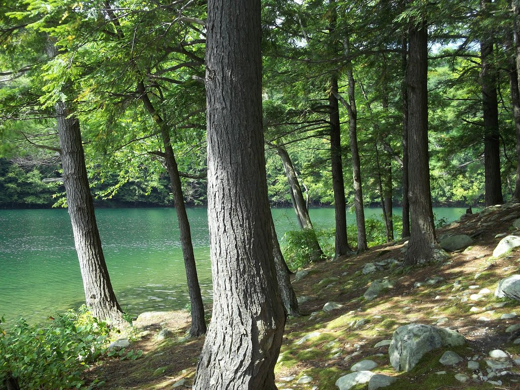
Just north of East Dorset, is Emerald Lake State Park. In
the early 1920s, Robert Alfred Shaw purchased more than 1,000 acres of land,
establishing North Dorset Farms. His acquisitions included the area surrounding
Dorset Pond, which is now known as Emerald Lake. In 1957, following Mr. Shaw’s
death, the State purchased approximately 1,000 acres from his estate.
Approximately 500 acres, located adjacent to the park on the east side of US
Route 7, is now Emerald Lake State Forest. The 430 acres on the west side of
the highway comprises the park. In 1960, Emerald Lake State Park opened to the
public. Located conveniently between Manchester and Rutland, the park is
popular for its wooded hillside campground, beach and swimming area, and nearby
attractions and tourist destinations. The park surrounds 20-acre Emerald Lake,
named for the emerald green color of its waters when viewed from above. Only non-motorized
watercraft are allowed on the lake, as well as swimming. The lake also offers fisherman
the opportunity to catch yellow perch, small mouth bass, northern pike and
other species. The park is a favorite destination of hikers, with the Long
Trail, Appalachian Trail and trails on Dorset Mountain.
 |
| Photo Credit: Pintrest |
The Dorset area became well known for its marble quarries by
the early 19th century. The first commercial marble quarry to open in the
region, and likely the country, was opened in 1785 by Isaac Underhill on Mt
Aeolus. The quarry age of Dorset spanned some 130 years. In the early years,
marble was cut for uses like headstones and hearthstones. Later, huge blocks of
stone were cut from the mountainsides at the quarry where they were placed on
an inclined rail system and sent a mile down the mountain to a finishing mill.
Finished stone was sent out on rail cars. During the quarry age peak, as many
as 30 quarries harvested stone for many uses, including projects like the New
York City library and many bank and public buildings across the country. Many
local buildings and sidewalks are made from the local stone. By the beginning
of the 20th century, however, quarrying marble in Dorset began to draw to a
close. Quarries further north in West Rutland and Proctor proved to yield
higher quality stone much easier than the rugged mountain quarries in Dorset. Other
former quarries remain as water-filled pits. We watched a TV documentary about the best swimming holes in the country. One of them is in Dorset, where an old marble quarry now attracts swan divers and belly floppers.

We continued to follow Route 7, through Wallington Vermont,
into North Clarendon. We diverted off Route 7, to arrive at Iroquois Land
Family Campground.
Tomorrow, we head from Vermont, through New Hampshire into Maine! Stay tuned!
No comments:
Post a Comment