We enjoyed our time at Dead Horse Ranch State Park, but I wonder how did it get its name? This is what I learned. Calvin “Cap” Ireys purchased Dead Horse Ranch in 1950. “Cap” told people that his children named the ranch. The first time the family looked at the property, they saw a dead horse lying in the field, and after looking at a number of properties, “Cap” asked his family which one they liked the best. The answer was the one with the dead horse. After they acquired the property, they named it Dead Horse Ranch. By 1971, “Cap” Ireys was ready to sell his ranch. He contacted the Arizona State Parks Board. The Board visited Dead Horse Ranch on October 25, 1971. The Board tentatively offered to sell 285 acres of the ranch comprising riverfront, pasture land, and bluff areas for $125, 000. Of the pasturelands, approximately 78 acres had historic water rights dating from 1874-1876.
These Quetta Pine (Pinus eldarica), have grown in a seed orchard at the entrance of Dead Horse Ranch State Park. They were planted in 1977 with a grant from McDonald’s Corporation. They are also called Mondell Pine and Afghan Pine. This drought resistant species is native to Afghanistan and Pakistan. It resembles the Mediterranean Aleppo Pine, but is a more cold hardy, faster growing tree.
We traveled on AZ-260 East, which starts or ends in Cottonwood. The western end of AZ-260 is located at State Route 89A in Cottonwood and heads eastbound along much of the Mogollon Rim, finally ending at its junction with US Route 180 and US Route 191 in Eagar. We are taking it all the way to the end or beginning!
The Coconino National Forest is one of the most diverse National Forests in the country. We have seen the famous red rock landscapes of Sedona. No we are experiencing the Ponderosa pine forests and looking forward to the southwestern desert and alpine tundra. We travel through and along the National Forests for most of the day!
At over 2.9 million acres, the Tonto National Forest is the largest national forest in Arizona, and the seventh largest national forest among 154 USDA National Forests. The Tonto features some of the most rugged and inherently beautiful land in the country. Sonoran Desert cacti and flat lands slowly give way to the highlands of the Mogollon Rim. This variety in vegetation and range in altitude from 1,300 to 7,900 feet.
What a great name …. Maybe Plant City Florida, should have had this town name. Strawberry. A mild climate, fresh mountain air, fertile soil, and, of course, plenty of towering pine trees. It’s easy to see why Strawberry's original settlers, a group of four Mormon families, decided to call this spot home in the late 19th century. Their roots took hold, and this small community that hugs the scenic Mogollon Rim between Camp Verde and Payson continues to thrive. Gold in the hills, discovered around 1875, began the influx of settlers to the area. It was these early residents that gave Strawberry its colorful name, inspired by the wild strawberries that grew across the land. They also established the Strawberry Schoolhouse in 1885. It still stands today as the oldest schoolhouse in Arizona. Notable sights within the town include the historic post office, established in 1884, and the Pine-Strawberry Museum, which opened in 1979 and takes its name from its sister community of Pine and Strawberry. The huge Ponderosa Pines that have been growing for hundreds of years in the Tonto National Forest Preserve that surrounds the quaint mountain town of Strawberry.
We passed through Payson, whose community moniker is ‘America’s Coolest Mountain Town.’ We have seen the Granite Dells in Prescott, but did not know there were any futher south in Arizona. Located a few miles southeast from the center of Payson is an area known locally as the Granite Dells. The Stewart Pocket geological structure lies at the heart of this picturesque site. The deep, wide ravine stretches for several miles, both north and south of the area; the pocket marks the trailhead for the loop. Stewart Creek drainage is contained within the pocket and evidently the creek is the natural force that created this unique place.
The Apache-Sitgreaves National Forests, administered as one national forest, it encompasses over two million acres of magnificent mountain country in east-central Arizona. The Sitgreaves National Forest was named for Captain Lorenzo Sitgreaves, a government topographical engineer who conducted the first scientific expedition across Arizona in the early 1850’s. On the Sitgreaves, the major attractions for the visitors from the desert is the Mogollon Rim and eight cold-water lakes.
The Mogollon Rim is a rugged escarpment that forms the southern limit of the Colorado Plateau. It extends across the entire forest and provides excellent views within Plateau Country and Desert Canyon Country as well. Dropping as much as 2,000 feet in some areas, the Rim provides some of the most far-reaching scenery in Arizona. Views stretch from its rocky precipice to Four Peaks of the Mazatzals northeast of Phoenix.
The Apache
National Forest ranges in elevation from 3,500 feet to nearly 11,500 feet and
is named for the tribes that settled in this area. The area from Mount Baldy
east to Escudilla Mountain is often referred to as the White Mountains of
Arizona. From the edge of the Mogollon Rim south of Hannagan Meadow, the land
drops precipitously into the high desert around Clifton.
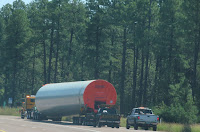
We passed by this first oversized load and as we went on we passed three more. It was a great road for these oversized loads, becasue there were very few overhead lines. There were just a few grades to climb! We thought they were bases for wind turbines, but they really look too big for that!
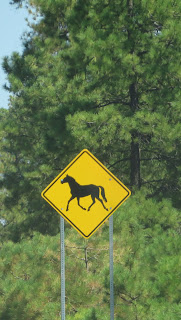
Okay, another “crossing” sign for my collection. It’s a wild horse crossing sign. I learned that this area is home to the Heber Wild Horses. They are protected by the 1971 Wild and Free-Roaming Horses and Burros Act. They roam an area of the Apache-Sitgreaves National Forest, near the Heber-Overgaard area.
The horses draw curious onlookers, animal lovers, and photographers from around the world. There are more than 400 horses in the herd currently. The United States Forest Service is entering the final stages of its plans to remove, or sterilize, more than 300 of the wild horses near Heber, giving the community less than a month to weigh in on the decision.
As the only horses in the state with their own dedicated territory established in 1973, the Heber horse herd was placed under a federal court order of protection in 2005. They are protected, but a 47-page management plan from the Apache-Sitgreaves National Forests proposes a reduction in the size of the herd from about 420 horses to no more than 104.
Sho Low what a unique name for a town. How did it get its name? Rumor has it, that early day settlers Corydon E. Cooley and Marion Clark had been neighbors for a short time, living among the lush, green ponderosa forestland along Arizona’s Mogollon Rim. For whatever the reason Cooley and Clark agreed it was getting too crowded and one of the two parties had to move. The issue was to be settled, not by intimidation or gunplay, but with a deck of cards. The game, called Seven-up, where low card wins, was a favorite among frontiersmen. The game reached its climax when Clark said to Cooley as he dealt the last hand, “If you can show low, you win.” At this point Cooley turned up the deuce of clubs and declared “Show Low it is.” Marion Clark moved on down the road a piece and Cooley named the settlement that grew up near his ranch, “Show Low,” in honor of the now-famous card game.
Flags were set out for Patriots Day and to remember the events of 9/11. We love to see the small town patriotism at times like these.
We arrived in the town of Springerville AZ, its 13 miles from the New Mexico border. Originally established in 1879, it sits at an elevation of 7,000 feet. Growing around Henry Springer’s trading post, the town was incorporated in 1948. Along with its neighbor Eagar, both communities reside in the Round Valley within the White Mountains of Arizona.
We took a self guided toured the White Mountain Historical Park and were pleasantly surprised. The entire property is so well maintained - clean and inviting. It's easy to move around and there's tons of stuff to see. Between the original homes and buildings to the tools and equipment from so long ago, it's easy to get a mental snapshot of how it must have been to live here then and to settle the area.
We are staying at Springerville RV Park, a Passport America park with a $20 a night rate. Prefect place to stop, except … no over the air TV stations! But, at least it was cool enough to sit out until after sunset!
#TwoLaneAdventures


No comments:
Post a Comment