Thursday, May 8, 2025

Day 7 of our 2025 RVing Adventure with Historical & Musical Interludes

For day 7 of our 2025 summer adventure we traveled in a two RV caravan from St Augustine to Richmond Hill, just south of Savannah.


We crossed the "Lion Bridge" and passed the Castillo de San Marcos. It is a 17th-century Spanish stone fortress with views of the St. Augustine Inlet. 


This massive fortress was built to protect the city from foreign invasions during Spanish rule and is the oldest remaining European Fort in the USA. It is an amazing structure made of coquina stone.

We took 295 around Jacksonville and got onto Highway 17. We will travel on Highway 17 for most of the trip today. US 17 was one of the original routes of the US Numbered Highway System, which was established in 1926. 
Jacksonville is called The River City for good reason. The wide St Johns River bisects this sprawling city and runs into the Atlantic Ocean to the east while the whole of a large St Johns tributary, the Trout River, lies completely inside the Jacksonville city limits. Add a high water table and land that, at its highest point, is only 40 feet above sea level, and you have a very watery place that's prone to flooding, with more than 13 percent of the sprawling city's 875 square miles, the largest surface area of any US city in the lower 48, under water.


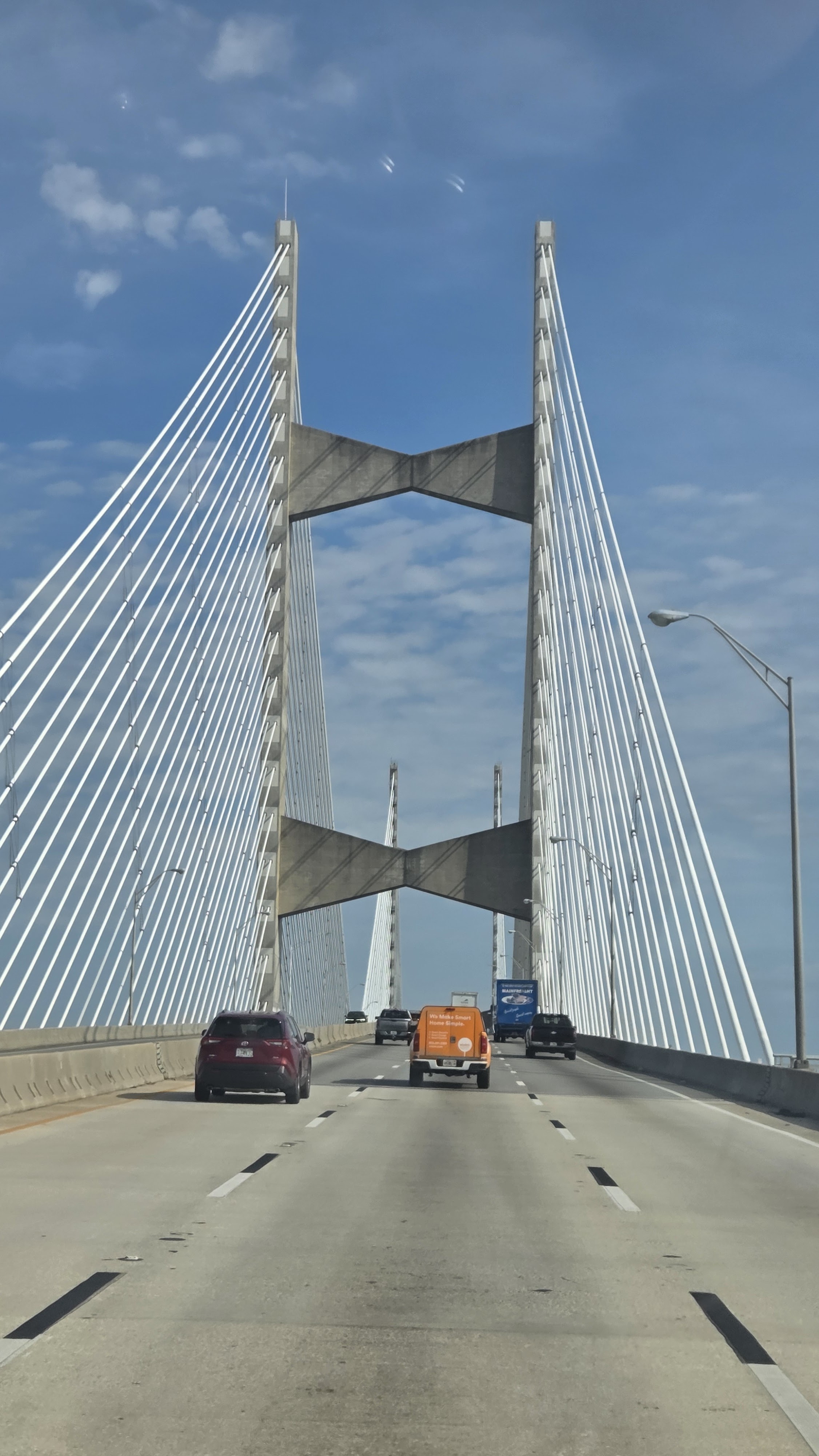
Jacksonville has seven major bridges over the St Johns River and one over the Trout River for a total of eight major bridges for road traffic in Jacksonville. We crossed the Napoleon Bonaparte Broward Bridge (or, the Dames Point Bridge) over the St John’s River. At two miles long, the Dames Point Bridge is the longest concrete cable bridge in the United States. It seems to be a popular place for ghosts. The 1988 structure is said to be haunted by an African-American woman whose apparition is seen walking along the bridge. Reports say she died when she was thrown over the bridge by an unknown attacker. Several others are rumored to have intentionally jumped from the bridge.

We went through Yulee Florida. The community was named for David Levy Yulee, a United States Senator from Florida. After Yulee, we quickly approached the FL / GA line. The Florida Georgia State line along US 17 is the St. Mary's River. It is actually a rambling stream of black-water that separates Florida & Georgia on the east coast. It starts in the Okefenokee Swamp and winds along a 130 mile path leading to the Atlantic Ocean & the Cumberland Sound. Total distance "as the crow flies" is about 40 miles.

A long this section of US 17 is the “95 Coastal State Bicycle Route.” It runs from the Florida Georgia line to South Carolina. The interesting fact is … we have seen zero bicycles along this route!


This route is also the Gullah Geechee Cultural Heritage Corridor. It is a federal National Heritage Area and it was established to recognize the unique culture of the Gullah Geechee people who have traditionally resided in the coastal areas and the sea islands of North Carolina, South Carolina, Georgia and Florida. Throughout the Gullah Geechee Cultural Heritage Corridor today there are vibrant and historic Gullah Geechee communities to visit.

Kingsland, Georgia, has a rich history, rooted in its location within Camden County, one of Georgia's oldest counties. The town's history includes significant roles in the War of 1812, the story of influential families like the Joseph family, and the legacy of the Kinlaw Rosenwald School. Kingsland was named after William Henry King. The town was founded in 1894 and incorporated in 1908. 

We passed Jekyll Island GA, traveling along US 17 N into Brunswick GA. We traveled along the Marshes of Glynn County. 100 years ago Georgia poet Sydney Lanier immortalized the Georgia marshes in his poem "The Marshes of Glynn."  Check it out sometime! 

All along these marshes we saw signs for shell recycling locations. Shucked oyster shell are needed to cultivate and restore oyster beds. Shells need to be returned to the estuary to provide a suitable surface to attract juvenile oysters. More often than not, the shell ends up in driveways and landfills. Recycling your shells will help restore, preserve, and enhance the state's inshore marine habitat. Oysters reefs provide habitat for fish, shrimp, crabs, and other animals. 

Why is this area called the "Golden Isles." The dreams of the coast’s earliest explorers who traveled from afar and waded ashore in pursuit of glittering treasures and riches.  The color gold prevails here; in the hues of our beautiful beach sands, in the warmth of the summer’s sun, in the shades that paint the vast marsh grasses in winter and in the rich treasures that are experienced here, year round, by residents and visitors. The Golden Isles of Georgia are a group of four barrier islands and the mainland port city of Brunswick on the 100-mile-long coast of the U.S. state of Georgia on the Atlantic Ocean. 

They include St. Simons Island, Sea Island, Jekyll Island, Little St. Simons Island, and Historic Brunswick. Since the American Civil War, all the islands have become elite resorts frequented by some of the nation's wealthiest families. New Hope Plantation lies between the west bank of the South Altamaha River and the Coastal highway. This 1,100 acre tract is all that remains of a Crown grant made in 1763 to Henry Laurens. 

Gary & Sheryl enjoyed the drive along this two lane road. Sheryl especially liked the tree canopies that we drove under several times along this trip.

Wednesday, May 7, 2025

Day 6 of our 2025 RVing Adventure with Historical & Musical Interludes

Day 6 of our 2025 summer adventure was spent doing household chores, securing tickets, and waiting for our friends to arrive. 

This morning included my daily walk. It's amazing the beautiful and unique things you see while you are out in the mornings!

This guy looks over FL SR A1A everyday. There are thousands of cars that pass him everyday and how many drivers know he is there?


I found this residential street that is a half moon from A1A. You are not that far off the main road, but it was so quiet along the road. This flag was beautifully framed by the Spanish moss and oaks.


This headless statue was part of a garden in someone's front yard. Some people are so creative!

Then we went to A1A Beachline Laundry then it was back to the RV and a late brunch.

Then, it was time to get on the computer and secure IBMA tickets. They went on Sale today! We are IBMA members and we got tickets to the Awards Show, the Festival and all the Showcases!

Gary & Sheryl arrived around 1:30pm and at 3pm, we were in the Elks bar. They were paying their bill. Charlie and Sheryl were enjoying adult beverages. We all were laughing with the bartender and enjoying the company of dear friends.

The rain came, while we were in the bar. Charlie kept saying, we should have driven the car! LOL He got wet and went back to the campers to get the car to drive to dinner.

We left the lodge, as they had a business meeting tonight. Audrey, the bartender, suggested the Floridian for dinner. But, we opted for a more casual atmosphere. Our plan was to go to the Beachcomber. There was zero parking available, so our first choice was out. We passed another cute place on the way to the Beachcomber. There was a parking space there and it was semi-close to the restaurant. We enjoyed a great dinner at Mango Mango's Caribbean Grill. Only picture I took was my and Sheryl's Fish and Chips. The cole slaw had Mango in it and the tater sauce had a mango flair to it! Gary's Caribbean salad looked fabulous!

Our night ended with a route review for tomorrow's drive to Savannah and beyond. With a few more laughs, for good measure!

Stay tuned for more Two Lane Adventures!

Tuesday, May 6, 2025

Day 5 of our 2025 RVing Adventure with Historical & Musical Interludes

For day 5 of our 2025 summer adventure, we drove through Palatka again on our way to our home for the next two nights, St Augustine. This morning I lingered a bit at the springs. I was lucky to capture two blue crabs as they meandered in the water. Its amazing that in just a few hours this peaceful serene scene will be full of people in the water and all the wildlife tucked safe away until the people leave again.

Palatka was established as a trading post in 1821. The name comes from the Timucuan Indian word Pilotakata, meaning "crossing." The original settlement was burned during the Semionole War of 1836. In 1838, the US government constructed Fort Shannon, which served as a garrison, supply depot, and hospital for the forts in the area. During the American Civil War, Federal troops occupied the city. During the postwar period, riverboats plied the St Johns River to points south and Palatka became the gateway to the interior of Florida. Palatka became known as the "Gem of the St Johns" and boasted several world-class hotels that included the Arlington, Saratoga, La Fayette, and the Putnam House, with accommodations to host 6,000 visitors. Palatka prospered in the late 1800s as an enormous resource for timber and citrus and had a reputation for natural beauty that attracted many visitors. A devastating fire in downtown Palatka in 1884 destroyed many of the grand hotels and deep freezes in 1894 and 1895 devastated the area's citrus industry, causing a decline in the area's visitation and industry.

On the side of the Riverfront Nutrition building is one of the twenty murals that adorn downtown Palatka. This one is a nod to the annual "Mug Race Weekend". Yachters gather together here in Palatka and spend the day sailing up to Jacksonville. Of course, since the river flows north, they are actually sailing down river. The artist was Carolyn Stevens and the sponsor of the painting on this mural was the Palatka Yacht Club.

Separating Palatka and East Palatka is the St John’s River. Visualized in 1921 at an estimated cost of $375,000, the Memorial Bridge spanning the St. John’s River was completed six years later. The bridge was considered at that time to represent the highest type of modern architectural style and construction methods. The final cost of the construction was $1.25 million leaving city leaders scrambling for a way to recoup their funds. Thus the bridge was initially set up as a toll bridge, and the fee to cross ranged from five cents to a dollar depending on the means of crossing. Tolls were to be eliminated when the bond issues used to pay for it were retired. The bridge would only last fifty years, and the new Memorial Bridge you drive on today was completed in the spring of 1977.

Four life-like copper statues, commemorating the soldiers who served, stand at both ends of the Memorial Bridge. They are affectionately known as World War I Doughboy Statues. The statues guard the base of the bridge on both sides. They were erected on the site by nationally known artist E.M. Viguesney of Spencer, Indiana. The statues have been given national publicity and nearly one hundred other statues like them have been erected to date. The “Spirit of the American Doughboy” is the only statue in the world that has the endorsement of the American Legion as being 100 percent perfect. It never was; in fact (endorsed by the American Legion), Viquesney was forced by legal action in 1936 to cease such claims.

St. Augustine's history is evident in its well-preserved historic district, which is a National Historic Landmark. The city's architecture, cultural institutions, and vibrant arts scene reflect its rich and diverse past. St. Augustine continues to be a popular tourist destination and a reminder of the early days of European colonization in North America.

St. Augustine became part of the United States and later Florida State, facing development and cultural changes. The arrival of Henry Flagler in the late 19th century transformed the city into a popular tourist destination, with grand hotels and new architectural styles.


We will talk more about St Augustine later. We are spending the next two nights at the Elks lodge. We enjoyed talking to fellow Elk members at the bar and it was Taco Tuesday, so no cooking for me! Stay tuned for more Two Lane Adventures!

Day 4 of our 2025 RVing Adventure with Historical & Musical Interludes

For our day 4 of our 2025 summer of travel we had a leisurely morning at the campsites. Later in the morning, we took a drive to Palatka. We drove for miles with the Ocala National Forest on both sides of the road. We came to a steep grade in the road. We were going over the Cross Florida Barge Canal. Us west coast Florida people say " a barge canal in Florida?"

Yes, parks and park projects were built in the New Deal era by the Civilian Conservation Corps. New Deal funding for the canal ran out within three years. Local critics insisted that the canal would disrupt Florida’s aquifer and waterways. National opposition grew in response to claims that the project was a waste of taxpayer money and of limited value to people outside of Florida.

But hope for the canal had yet to run out completely. During World War II, German submarines threatened Florida’s coasts and shipping lanes. During World War II, Congress modified the former sea-level canal project into a lock and dam shallow-draft canal along the same route as the original sea-level project. After the war, rivalry between the United States and the Soviet Union intensified. Canal boosters pointed to project as an asset to national security and rehashed old arguments in its favor. Construction resumed in 1964, with President Lyndon B. Johnson presiding at the groundbreaking in Palatka, Florida.

However, the canal was ultimately not to be. There was a new surge of environmental awareness in the 1960s, and major opposition to the canal emerged. 
Heading a group called the Florida Defenders of the Environment, activist Marjorie Harris Carr appealed to President Richard Nixon and issued legal challenges to construction. Nixon stopped the project in 1971, ending a long-held but never-realized dream. Over the next decade continued legal battles ensued and the political momentum for the project waned. Congress eventually deauthorized the project in 1990. With the canal only about one-third complete, the land that had been secured for its path sat in limbo. So, what to do with the largest unfinished public works project in history? Turn it into a greenway and name it after the activist that halted the project, The Marjorie Harris Carr Cross Florida Greenway.

Its about 20 miles into Palatka from the park. Palatka, Florida is known for its history as a river port, its abundant outdoor recreational opportunities, and its rich cultural heritage. It's particularly famous for Ravine Gardens State Park. We will check that out on our next visit. The town's annual festivals like the Florida Azalea Festival and the Blue Crab Festival are big draws. 
Palatka was a major port on the St Johns River, playing a crucial role in transportation and commerce, particularly during its "golden age" from 1865 to 1895. 

The St Johns River is special because it's the longest river, 310 miles, in Florida and it's a significant recreational and economic resource. It's known as the "Bass Fishing Capital of the World" and is home to diverse fish species and wildlife. 
The St Johns River is one of the few rivers in the U.S. that flows north, adding to its uniqueness. The river also supports a major deep-water port in Jacksonville. 

We enjoyed a simple lunch at Sonic in Palatka. Charlie got Jim to a place that serves the hot dogs he loves! No pictures! But, it was a great day to sit outside and enjoy a meal with friends!

Along 19 in Rodman, is the Rodeheaver Boys Ranch. The Florida Good Sam's used to go there for Samborees. Ernie & Debbie Evans still have a bluegrass festival here. 
It was founded in 1950 by Homer Rodeheaver. Is the accumulation of a dream by an orphaned boy.  Homer’s mother died when he was only eight years and this created a lifelong desire to help other young boys who experienced the loss of a parent. Homer, known as Rody to his friends, and Billy Sunday were the most famous revival team of the early 20th Century.  

Rody and his brothers founded The Rodeheaver Publishers of Sacred Music in Chicago.  By 1912, they expanded into Philadelphia and then by 1938 merged with Hall-Mack Publishing Company.  A branch office was opened in Los Angeles with the symbol of the firm being a rainbow arched over a line of musical notes based upon Rody’s theme song, “Every Cloud Will Wear A Rainbow If Your Heart Keeps Right.” Rody is credited with starting the American custom of Easter Sunrise Services.  He continued to share his lifelong dream of helping needy boys in a warm, healthy Christian environment with influential businessmen.

During his revival tours, he came across Rodman, a small town near Palatka, Florida.  He started purchasing large tracts of land with the eventual goal of setting aside a portion of the land for his boys ranch.  Rody established a very profitable cattle, timber, and sawmill operation on the rest of the land. 
Initially named Rainbow Ranch after his music publishing company, it was eventually named Rodeheaver Boys Ranch.  Five years after Rody had realized his dream of establishing a Christian environment for needy boys, he died.

Today, the ranch sits on 800 acres of pristine land on the beautiful St. Johns River and it continues Rody’s dream of providing a safe haven for needy boys in a Christian environment. It provides a wholesome home environment with a program for social, educational, vocational, and spiritual development for boys who are at-risk or disadvantaged due to poverty, home insecurity, parental death, desertion, divorce, or other issues with the legal parent or guardian that are no fault of the child.

They exist because they know families sometimes struggle and believe boys need strong role models in their lives. “It’s Better to Build Boys than to Mend Men” is the Ranch motto and is just as relevant in our society today as it was in 1950 when this phrase was used by their founder, Homer Rodeheaver.  

Stay tuned to our Two Lane Adventures as we move to St Augustine, Florida tomorrow!

Sunday, May 4, 2025

Day 3 of our 2025 RVing Adventure with Historical & Musical Interludes

For our day 3 of our 2025 summer of travel we remained in the Salt Springs Recreation Area. Mother Nature gave us some much needed rain! Debbie and I did our walk around 10am, but the humidity came back with a vengeance after the rain stopped!


In the area around the picnic area and store is a 200 plus year old Southern Live Oak, whose branches dip and stretch skyward again! It is amazing the resilience that these mammoth trees have! Live oak branches droop due to a combination of factors, including natural growth patterns, heavy weight, and potential stress from environmental factors like drought or disease. 


The branches can spread outwards and downward, sometimes even touching the ground. This natural droop can be influenced by the tree's overall health and the specific conditions of its environment. 


Salt Springs is a second-magnitude spring that derives its name from its salt waters. The spring pool measures about 190 feet by 130 feet, with spring flow emerging from four vents in the limestone rock floor of the pool.


Gentle boils can be observed at the water’s surface over the vent areas. Limestone and sand are on the pool bottom near the vents, with the rest of the bottom covered with aquatic grasses. The north, west, and south sides of the pool are surrounded by a concrete walls. From the pool, water flows southeast about 4 miles down a broad run to discharge into the northwest corner of Lake George. The spring is part of the USDA Forest Service’s Salt Springs Recreation Area, where we are camped.


In the roped-off area between the swim area and the river toward the side were wire cages. I was thinking it was maybe for the crabs. It is not for the crabs but for bringing back the seagrass. The seagrass has receded because of all the foot traffic of people. Seagrass is an important food source for the manatees who migrate to this spring and others along the St. John River.


It has been said that Salt Springs is the legendary "Fountain of Youth." St Augustine might beg to differ with that statement! Scientists have discovered that aging can be slowed by certain minerals and trace elements that are available only in unrefined  groundwater, and the abundance and variety of helpful minerals in the water at Salt Springs can be found nowhere else in the US.

Want more history on the area? The King of Spain originally granted ownership of the property surrounding the Springs along with the five-mile run to Lake George to his supporters, the Hernandez family, who were not particularly attracted to the gift.  

Because of their lack of interest, the property remained undeveloped until the late 1800's when brothers, Walter and Columbus Townsend, who were prominent gentlemen in the turpentine business, saw an opportunity for shipping turpentine down Salt Springs Run and up the St. Johns River to the Naval Station in Jacksonville.


In 1900, Daniel Morgan, a prominent Marion County resident and County Commissioner who also owned a timber and turpentine business, constructed a large framed home on the south side of Lake Kerr. This grand lakeside home contained ten rooms, with the kitchen and dining room separated from the main house, all constructed of heart of pine and trimmed cypress.  When Mr. Morgan died accidentally, Columbus Townsend purchased the spacious house as a summer residence for his family, and proceeded to have it moved from the bank of Lake Kerr across the landscape to its present location, adjacent to the Springs.

Moving the house was quite a feat which took almost the whole year of 1918 to complete.  It was said that to move the house, they felled large pine trees laying them in front of the house as rollers and pulled the house with teams of oxen and cattle.

In 2009, there was some discussion about the old home being renovated into a bed & breakfast. The old home still stands on the south side of the Springs. They say from the second story windows, you can see the springs. I would not chance climbing those stairs to sneak a peek!


In 1908, President Roosevelt set aside the vast scrubland surrounding the Springs as the Ocala National Forest and only the  stouthearted braved the hazards of traveling the long deep sand roads to enjoy the waters of this remote jewel.

In the 1920's, after having bought his brother's interest in the property and having laid claim to the Hernandez grant, Columbus sold all of the property to the Ray family of Ocala.  With the coming of hard-top roads, many of Florida's natural treasures were popularized, but not Salt Springs; this remained a remote jewel but word had gotten out.  


Some came to be cured, believing that the waters had medicinal value, while others simply wanted to enjoy the bath of crystal clear waters. Regardless of the reason, all manner of homemade shelters sprang up among the oaks to accommodate the explorers who flocked to the Springs. 
In the early 1960's, Highway S-19 opened exposing the Springs to the world.  Portions of the scarce private land nearby was soon subdivided and sold as campsites to those individuals wanting their own slice of the Forest.

Over the years, most of those campsites have become permanent home sites, for both full-time residents and weekenders alike.

In 1979, the US Government bought the Springs from the Ray family, along with the approximately ten acres of the Hernandez grant, for over $12 million.  

Stay tuned as we explore the area a bit more tomorrow. Debbie and I might even put our toes in the 72 degree spring! 


Saturday, May 3, 2025

Day 2 of our 2025 RVing Adventure with Historical & Musical Interludes

Day 2 of our 2025 summer of travel was in the Salt Springs area between there and Barberville. I have heard much about Barberville, from our friend Sheryl, but we never have experienced it!


Debbie and I got 3 and 4 miles in respectively. We walked the many paved roads of the camping area and to the entrance and back a few times!

The Salt Springs Recreation Area is one the recreational jewels of the Ocala National Forest. The spectacular natural mineral spring gives the area its name. Plenty of outdoor activities keep campers and day-use visitors busy, including swimming in the springs, fishing, snorkeling, hiking and boating. 

In the early 1900s, many people came to the spring, believing it had medicinal healing powers. Today's visitors will find Salt Springs gushes a staggering 52 million gallons of water daily at a constant 74°. Debbie and I might put our feet in the water one of these days before we leave!


After a leisurely morning, we headed to the Barberville Yard Art Emporium on Route 40. Sheryl was right, you can not describe what you see there! This unique location is currently in the running for "most unique roadside attraction" in the USA Today Best 10.


If I had a ton of money, much of this one of a kind artwork would have come home with me!

We saw so many interesting and unique things. Some I would buy and hang inside!


Other things I would put outside for everyone to enjoy the beauty with me!


The most unique thing we saw today, was a friend we have not seen in about 30 or more years from Hemlock NY! Karen Locke is the mother of our son, Chris's best friend from high school, Teddy Decker. Karen and her husband Jerry had come to Barberville from the Villages with their neighbors. I was walking by and she said ... is that Wendy, no.... yes.... no.... oh, what the heck. She said are you Wendy Parsels? I said yes... what a small world! I called Charlie on the phone and he said "no S&%$?!" He made his way back over to say hello, too. We exchanged info and hope to get together in the fall!


Debbie and I could have walked around for hours, but Jim and Charlie were ready to go. Debbie wanted to get something for the front yard, but Jim was not willing to share his bed with the dinosaur until they get back to Zephyrhills! We will have to make another trip up here!


Naturally, we decided to stop somewhere for a bit to eat. 


We settled on Drifters Riverfront Bar & Grill in Astor, Florida.

It sits along the water's edge near a bridge over the St Johns River. We were seated next to the windows on the river. Our server Sarah was awesome. We must be creatures of habit. Charlie & Jim had BLT and fries. Debbie and I had Shrimp Tacos, hers were grilled and mine were blackened!


The mural outside of the restaurant was beautiful! We got back to camp mid-afternoon and enjoyed sitting outside and visiting! 

Tomorrow is another day for adventures! Stay tuned to follow more of our #TwoLaneAdventure

Day 1 of 2025 RVing Adventure with Historical & Musical Interludes

Day 1 of our 2025 summer of travel started in Zephyrhills on Friday May 2nd and ended at the Salt Springs Recreation Area. 
We are here for 4 nights. We tried to get Jim & Debbie into the caravanning mind set. I gave them a bit of trivia as we went along.

We took 301 through the town of Coleman, Florida. Coleman was once proudly called the "Cabbage Capital of the World." In 1923, it was known for it's rich agricultural history. The town's agricultural prominence stemmed from its production of cabbage and other crops like citrus, celery, and lettuce.

Additionally, Coleman is home to a significant federal prison, the Federal Correctional Complex Coleman, which includes several federal prisons. With some of America’s most notorious convicts reside within the federal prison complex in Sumter County. While specific "famous" inmates may be difficult to definitively identify, some notable cases have garnered attention. Including housing some if the "proud boys" after their convictions.

In Wildwood, Florida Jim had a hard time keeping the RV in the road. It really wanted to turn into the Coney Island Hot Dog shack!

Wildwood is known as "The Crossroads of Florida" due to it's central location at the intersection of major highways and its history as a rail hub. 

It was also home to the southern edge of The Villages, a large retirement community. Until the villages pushed further south a few years ago!
 

In the early 1900s, Wildwood had a unique, eight-sided building called the "Wigwam" that served as the town hall, courthouse, and a venue for recreational activities. 


Our trip was uneventful, which is always good. We arrived at Salt Springs Recreation Area two and a half hours after we left home.


The campground is the largest in the Ocala National Forest and the only one with full hookups for RVs. The campsites are spacious, level, nicely shaded and well away from the busy day-use area.