Monday, June 30, 2014

Traveling East & North Along Lake Ontario

From Williamson we drove into Sodus where you can follow the Lake Ontario Wine Trail. It is a unique trail featuring boutique wineries, great restaurants, bountiful farm markets, historic sights, and much more. But be advised, to follow the whole trail will take you four to six hours!
Part of the Lake Ontario Wine Trail is The Heluva Good! Cheese Country Store is a delightful place to experience a journey back in time. The wooden floors and marble counter top on which custom blocks of cheese are cut lend an old-fashioned ambiance to your shopping experience. The store features a complete line of the Heluva Good! brand, as well as specialty cheeses. The shelves are filled with gourmet food items and an impressive array of distinctive gifts. Custom gift baskets and cheese trays are also available. The store also is the headquarters for the Country Store Mail Order business. So next time you place that special order, you will know where it is coming from! Sodus Bay is one of
Lake Ontario’s major embayments separated from the lake by a 7,500-foot long barrier beach. 
The bay is 4.4 miles in length and 2.4 miles across. The Sodus Bay watershed is approximately 46-square miles. It is composed of land that is 30% agriculture, 4% developed land, 61% forest, and 4% wetlands. First Creek, Second Creek, Third Creek, Sodus Creek West, Sodus Creek East, Glenmark Creek, and Clark Creek empty into the bay. Wayne County’s shoreline embayments are of ecological importance containing over 6,807 acres of protected wetlands and host to over 36 species of aquatic plants including three species of protected aquatic plants and the protected soft-shell turtle. All the bays are the primary spawning sites of forage fish supporting the food base of the Lake Ontario sport fishery for salmon and trout. Marsh and open water habitats dispersed with emergent vegetation are critical for many marsh birds, including endangered species like the black tern, and threatened birds such as the least bittern, pied-billed grebe, northern harrier, and the upland sandpiper. Birds of special concern are the American bittern, osprey, common loon, sandhill crane, sharp-shinned hawk, bobolink, eastern meadowlark, marsh wren, Virginia rail, sora, Wilson's snipe, magnolia warbler, golden-winged warbler, brown thrasher, ring-necked duck, and wood duck. These marshes make great bird watching sanctuaries. Along 104 you can see the two dirt ruts in the grass marking the snowmobile trails. There are official markings for these routes, hazards and crossing areas. The Nine Mile Point cooling tower is visible from Chimney Bluffs in Sodus, nearly 30 miles away. We passed through Walcott, Martville, Hannibal and Oswego. We traveled along what is dubbed the Erie Canal National Heritage Corridor. The Erie Canal is the most famous and influential man-made waterways in America. It stretches over 500 miles across the full expanse of upstate New York. 
The Erie Canal National Heritage Corridor encompasses New York’s canal system and the communities that grew along its shores. It’s a place with stories to tell, great works of architecture to see, history to be learned, and hundreds of miles of scenic and recreational waterway and trails to explore. Located on high ground in Oswego sits Fort Ontario State Historic Site. The star-shaped fort dates back to the early 1840's.
There are two Guardhouses, a Powder Magazine, Storehouse, Enlisted Men's Barracks, and windswept ramparts featuring magnificent views of Lake Ontario and underground stone casemates. The fourth and current Fort Ontario is built on the ruins of three earlier fortifications dating back to the French and Indian War, Revolutionary War, and War of 1812.  It was occupied by the US Army through World War II. In 1946 Fort Ontario was transferred to the State of New York and housed World War II veterans and their families until 1953.  It opened as a state historic site in 1953. A post cemetery containing the graves of 77 officers, soldiers, women, and children who served at Fort Ontario in war and peace is situated on the grounds.
The American Legion in Oswego has beautiful murals painted by Jennifer Hall. Each mural measures 19 feet high by 8 feet wide and represents each of the Armed Forces. It is believed that this is the only Veteran's club with this type of painted murals outside of it's building. Outside of Oswego is the town of Scriba, home to the 
Nine Mile Point Nuclear Station. A two-unit nuclear power plant located on the shore of Lake Ontario. The 900-acre site is also occupied by the Fitzpatrick Nuclear Generating Station. When we entered Mexico where 104, Main Street, intersects with US Route 11.
We headed north out of town on Route 11.
The town of Pulaski was previously known by various other names. It was once called “Fishville” and sometimes it was called “Salmon River”. It was also stated that the name “Pulaski” was often spelled “Polaski”. It was also used for years with the spelling of Polaski from The Palladium Times to official state documents. The local historian, offered two possible theories regarding the selection of the town's name in an article titled "Name Selection is a Mystery." According to the historian, the most credible theory is that in 1829, three years before the town's incorporation, the prominent lawyer and abolitionist Thomas C. Baker proposed the name at a meeting. Another story indicates that the name was chosen when Revolutionary War heroes put names in a hat and pulled the name of Casimir Pulaski. The historians believe that one or both may not be true but it creates good folklore. 
A few miles to the west from the village of Pulaski at the mouth of the Salmon River sits the Selkirk lighthouse. In the 1830s the government engineers determined that the mouth had sufficient depth that it could harbor thirty ships. So in August 1838 the lighthouse was inaugurated. The lamp originally ran on whale oil. Due to the lack of importance of the harbor it was deactivated in 1858. The Salmon River, stretches 17 miles from the Lighthouse Hill Reservoir in Altmar to where it empties into Lake Ontario at Port Ontario. There are 12 miles of Public Fishing Rights along the river. The Salmon River offers some of the finest sport fishing in the country, especially for ChinookCoho Salmon, Atlantic Salmon, Steelhead, and Brown Trout.
We can add a few more crossing signs to our list, we saw Amish buggy crossing and snowmobile crossing signs. 
Near Sandy Creek, is the Eastern Lake Ontario Dune System which offers many opportunities for hikers, birdwatchers, canoeists, and kayakers. Walkovers and viewing platforms have been built to protect the fragile dune environment. 
Sandy Island Beach State Park is an attraction with natural sand dunes, sparkling blue water and a warm stretches of beach. It is part of the Eastern Lake Ontario Dune and Wetland Area, a seventeen-mile stretch of shoreline, which extends from the Town of Richland, north along Lake Ontario to Jefferson County. The dunes were formed by wind and wave motion of a giant inland sea that preceded Lake Ontario. Pierrepont Manor is a hamlet east of Ellisburg village on US-11. It was first settled around 1805 and is the birthplace of baseball
player Frank Smith. He 
was a right-handed pitcher in Major Leagues until 1915. He played for the Chicago White Sox, Boston Red Sox, Cincinnati Reds, Baltimore Terrapins, and Brooklyn Tip-Tops. Nicknamed "Piano Mover" because that was his off season job. We traveled through Adams, Adams Center, into Watertown. We crossed over the Black River and headed onto Fort Drum. Stay tuned for our next leg of this two lane adventure!

Sunday, June 29, 2014

Traveling East just South of Lake Ontario

We left on Friday morning to head north. We traveled on Route 15A north starting in Hemlock, NY. Do you think Hemlock New York was named after the poison or the tree? The more familiar species is Conium maculatum, Hemlock or Poison Hemlock, is a weed known almost worldwide for its toxicity to many domestic animals and to human beings. It produces a large number of seeds that allows the plant to form thick stands and reproduces easily. The Eastern Hemlock Spruce is long-lived and has no off-season. It is a slow-growing long-lived tree which unlike many conifers grows well in shade. Hemlock may take 250 to 300 years to reach maturity and may live for 800 years or more. The woods that surround Hemlock Lake, does not help make decision any easier, as the area is still mostly untouched by man! Route 15A is also known as Plank Road. It was made from planks before the turn of the century.
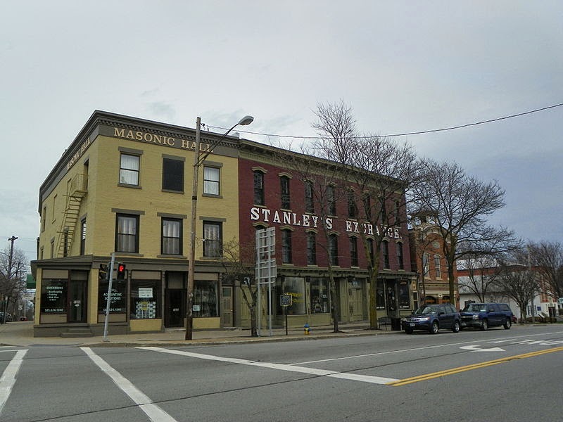
File:Lima NY hist dist 2.JPG (wikimedia commons)
The next town we hit was Lima, it boasts itself as the Crossroads of Western New York. It is famous for it's annual Crossroads Festival, especially the bed races! The Stanley's Exchange Building still stands at the four corners. Daniel Stanley owned the exchange or bank and several other businesses on the block, as well as some farms. We was referred to as the Banker Gentleman. 
Lima has been called many names:  Brick School House Corner, Mighell's Gore and Charleston.  But whatever the name, Lima is a community where neighbors reach out because they care. Dyer Straights, despite the pun in the name (based on the name of the owners), is a driving range and pickle all courts on 15A that offer facilities suitable for a range of skill levels. Never heard of pickleball, it is a combination of tennis, hand ball and table tennis. Google it!
Rush New York Water Reservoir
Just outside of Rush, if you look through the trees to the west, you can see a water reservoir. Here is how the water flows to this reservoir. 
Hemlock and Canadice, two pristine Finger Lakes located about 30 miles south of Rochester, are the primary source of drinking water for the City of Rochester. The water from these lakes is treated at the Hemlock Lake Filtration Plant before an 18 mile conveyance to Rush Reservoir, located in a non-public, countryside setting. From there, water is transmitted another 12 miles to the Highland Reservoir and Cobbs Hill Reservoir, both historic landmarks located in public parks within the city. So the lake that is named after poison or trees is the source of water for a city, where is Dr Evil when you need him! Just as you enter Henrietta, you see the Dome Arena. It is the former home to the Monroe County Fair. Long story, but if you want to learn more, Google Monroe County Fair Collapse. Sad, sad day for a large county fair. Makes me proud to be a part of such a solid fair board at the Hemlock "Little Worlds" Fair. Also in Henrietta is the Richardson farm.
Richardson Barn stands today amid thriving businesses
The barn still stands it was an Underground Railroad stop. The former Underground Railroad Station owner Dave Richardson was known by blacks for his booming voice, 250 lb., 6 ft. frame. This site is part of the 
Rochester-Monroe County Freedom Trail. The Underground Railroad, which flourished from the end of the 18th century until the end of the Civil War, comprised hundreds of secret hideaways along a trail through 29 U.S. states and Washington, D.C. Several thousand former slaves used the trail to secure their freedom by traveling to northern states and to Canada. We skirted downtown Rochester by taking a few side streets to see old neighborhoods, family and friends, finally reaching 104 E. We crossed over Irondequoit Bay, which is fed by Irondequoit Creek to the south and flows into Lake Ontario at its northern end.
picture can be found at http://www.ci.webster.ny.us/
We drove the 
Irondequoit Bay Bridge carrying the six-lane New York State Route 104 over the bay at it's deepest point 80 ft into the town of Webster. The town is named after orator and statesman Daniel Webster. The population is well over 50,000. The town's motto is "Where Life Is Worth Living." If life is only worth living in Webster, why is the population not greater? Along 104 you can see the old Xerox buildings. There was a time in the greater Rochester area where it seemed like nine out of every ten people work at Xerox or Kodak. Sadly, both businesses have fallen on lean times and their presence here has diminished.
article relating to picture at https://www.waynetimes.com
 In 
Williamson you can enjoy track or drag racing. Spencer Speedway opened in 1955 and is a 1/2 mile Flat Ashplat Oval. The track is currently NASCAR Sanctioned as part of the Whelen All-American Modified Series. The Speedway also has an 1/8 mile drag strip that runs Saturday Night and is NHRA Sanctioned. All along Route 104 you can see apple orchards, fresh apples from the tree is probably one thing we miss from NY, besides our kids and grand kids. New York is the second largest apple producing state in the United States, they average 29.5 million bushels of production annually. These apples are grown on over 50,000 bearing acres in six major production districts throughout the entire state. 
There are approximately 694 commercial apple growers in New York State. Here are some apple facts: On average, 13,250,000 million bushels (53%) are utilized as fresh fruit: 662,500 bushels (5%) are marketed directly by growers and “roadside markets”; 1,325,000 bushels (10%) are exported to other countries; and 11,262,000 bushels (85%) are marketed domestically through independent and chain supermarkets, food service and military outlets. About 11,750,00 bushels (47%) are utilized for processing: 4,465,000 bushels (38%) are processed into juice and cider; 5,522,500 bushels (47%) are processed into canned products, including sauce, slices and pie filling; 1,175,000 bushels (10%) are processed into frozen slices and 587,500 bushels (5%) are processed into vinegar, jelly, apple butter, mincemeat, and dried products. The top varieties produced are: McIntosh, Empire, Red Delicious, Cortland, Golden Delicious, Rome, Idared, Crispin, Paula Red, Gala, Jonagold and Jonamac.
more info at http://rwdsu.info/en/archives/5/strike-motts
 The Mott's Apple production facility in Williamson was the center of a 
labor dispute, forcing union workers to strike in 2010. Local 220 (RWDSU), voted to strike after Mott’s parent company, Dr Pepper Snapple Group (DPS)-- despite healthy profits, an increase in market share and a skyrocketing stock price—proposed serious cuts to employee benefits. The proposal from the company included a US$1.50 per hour wage cut for all employees, a pension elimination for future employees and a pension freeze for current employees, a 20 percent decrease in employer contributions to the 401(k) and increased employee contributions toward health care premiums and co-pays. DPS came under criticism for proposing cuts to worker pay at a time when not only was the local economy in turmoil, but the top three executives at DPS had doubled their pay between 2007 and 2009. The Williamson plant is the only plant that produces Mott’s applesauce, including the single serve packages. The contract was later settled.
We will end this blog somewhere 
along Route 104, the verdant byway that skirts just below Central New York State's Lake Ontario's shoreline, at a glorious waystation of burgers, red hots, and ice cream known as Orbakers Drive in. Bustling with activity on both sides of its traditional, pull-up-a-stool counter, the burger and entree choices are endless. They have been around since 1932 ... Famous for the Glutton Burger. What is a Glutton Burger? It consists of 2 steak burgers, 3 slices of ham, 4 slices of Swiss cheese, 4 slices of bacon, lettuce, tomato, mustard, special sauce, relish, and hot sauce on a toasted bun, after that meal there's 50 flavors of ice cream to wash it all down! Check back as we travel further east along 104 in New York State.

Thursday, June 12, 2014

Heading North - 7th Leg

Today, we left our temporary home by the relatives tiki-hut and headed north. It was a great stopping spot and enjoyed all the time we spent there! We will miss the two toilets and showers so close together! Even at a campground, we have not had a shower just a few steps from our front door! The tiki-hut was a great place to relax, watch TV and enjoy the visit! We stopped by the organic farm that our brother-in-law works at. It was pretty cool! The ladies grow there vegetables and free roaming chickens. They sell the vegetables, flowers and eggs to the high end restaurants in NYC. They even have a couple of their own bee hives for pollination. It is amazing what a small 26 acre farm can produce!
We followed route 206 into Trenton and saw the Trenton battle monument. It commemorates the American victory at the first Battle of Trenton, NJ, which occurred on December 26, 1776. It is located in an area of the city known as “Five Points.” It was here, at the intersection of North Broad Street, Warren Street and Brunswick, Pennington and Princeton Avenue, that the American artillery was placed. From this vantage point, the artillery dominated the streets of Trenton. The significance of the patriots’ victory at Trenton was not forgotten in the ensuing years. Three years after the battle, colonial secretary of state for King George III, Lord Germain, told Parliament “… all our hopes were blasted by that unhappy affair at Trenton.” From 206 we traveled on Route 31, heading through Pennington and Hopewell. That area reminded me of an old friend of my father that helped us with a large phone collection in my parents estate. I found his name in a circular, it was an unusual name, so I reached out to a man in NJ and it turned out that it was my father's friend. He still dabbled in old phones and was able to really help us! Thanks Walt! Looking for a new home? We found a beautiful place for sale and I love the name, the Emerald View Farm. It sits atop a hillside with breathtaking views spreading over the valley below. A long drive carries you to the custom built home with a welcoming porch that wraps around. Beautiful millwork and an open floor plan integrates the sun filled family room with a dream kitchen, featuring granite counters and stainless steel appliances. A wing that could be a 2 bedroom in-law suite. Upstairs the master bedroom respite includes a fireplace, his & her walk-in closets, and a large balcony for morning coffee. 3 additional bedrooms and the laundry make up the 2nd floor. Downstairs is an in-home theater and a family entertainment room. Thru the French doors is the magnificent patio, kitchen, and koi pond with waterfalls. For the equestrian, there is a superb 12 stall stable, 5 paddocks, and a riding ring. If we had the money, this could be our summer home for many of my friends! We traveled on the Tri-County Purple Heart Memorial Hwy. By renaming Route 31 a Purple Heart Highway it will stand as a reminder of the unwavering courage of each and every Purple Heart recipient. The Purple Heart recognizes the sacrifice of one’s personal safety. We can never repay our wounded warriors for their willingness to serve regardless of the potential consequences. When you drive this route remember all the men and women who gave so much to defend our freedom. Many of the towns we traveled near or streets we drove by included food in their name, or maybe I noticed them, because I was hungry! We saw Cherryville, Molasses Hill, Cokebury, Walnutport, Orange Grove, Graindale, and Limekiln. Yummy, maybe it is time for lunch! Found a great place to stop at Spruce Run Reservoir. It is surrounded by the rolling hills of Hunterdon County, Spruce Run Recreation Area is popular with picnickers, swimmers, fishermen, boaters and campers. The reservoir was one of the first water supply facilities to be constructed and operated by the state and covers 1,290 acres with 15 miles of shoreline for recreation. Spruce Run is the third largest reservoir in the state after Round Valley and Wanaque reservoirs. Traveled into Washington, NJ it's motto is “Hometown Friendly." No matter where we move, we always remember our "hometown." Comment on where is your hometown and what makes you remember your hometown?
We headed west on Route 46 and went by Furnace Lake which was once built for practical purposes of flood and erosion control is now a quiet lake area known as Oxford Furnace Lake in Warren County, New Jersey. Named for the first hot blast furnace in America, Oxford Furnace was also the longest continuous iron producer in the US until 1884. Oxford Furnace Lake is now a cozy area for families to picnic, hike, swim, and enjoy the great outdoors away from a noisy populated area. Kayaking, canoeing, and boating are popular on the clear water, but electric motors are not allowed to maintain a quiet and peaceful retreat feeling. Local anglers boast that the fishing is great is for bass, musky, perch, crappie, catfish, trout, bluegill. Ice fishing makes the lake a year round fishing destination as seasoned anglers boast that when the water is between 36 and 42 degrees really big bass will snap up your bait. Thought of a friend of ours when we passed the James Ramsay Farmstead. Knowlton Township Historic Commission worked tirelessly to open Ramsaysburg. The revitalization of the18th century Ramsaysburg Tavern, one of several historic structures at the river-front complex that has under gone restoration. Restoration was possible by grant funding obtained by the Knowlton Township Historic Commission.
These two laners moved across the Delaware Water Gap. New Jersey is the only state that let's you in for free, but every road out of the state requires a toll! Kind of like 'Hotel California' ... Come and stay but you can never leave! The Delaware River Gap is a 40-mile river valley. The Delaware Water Gap National Recreation Area encompasses nearly 70,000 acres along the Middle Delaware National Scenic and Recreational River in Pennsylvania and New Jersey. At the southern end of this park the river cuts an S-shaped pass through the mountains, forming the Delaware Water Gap. Millions of years of uplift, erosion, and glacial activity gave us the Water Gap, lakes, streams that flow through hemlock and rhododendron laced ravines, and the waterfalls that pour off the Pocono Plateau. The crisp, cool air around the waterfalls is refreshing, especially in summer. In the 1800s resorts flourished throughout the region where city dwellers arrived by carriage or rail, often spending the entire summer away from the urban heat. The Water Gap became a scenic wonder for fashionable travelers. Today the river and its valley remain a major vacation haven. Although transportation and the lengths of stay may have changed, many who remember family trips, summer camp, or their honeymoon return to reminisce at a favorite site in the park. In 1965 Congress established Delaware Water Gap National Recreation Area to preserve this natural, historic area and to enjoy this rural vacationland. We had to do it ... There is no direct two lane roadway across PA. Interstate, that dirty four lane word ... We got onto and traveled Interstate 80. How boring!
We saw fog and mist in the mountains of PA. We also saw Lake Harmony a dammed glacial lake and Hickory Run State Park. The 15,990-acre State Park in Carbon County, lies in the western foothills of the Pocono Mountains. This large park has over 40 miles of hiking trails, three state park natural areas and miles of trout streams. Boulder Field, a striking boulder-strewn area, is a National Natural Landmark. Finally, we hit Route 15 and moved along on our journey. We saw an office complex Water Tower Square, that actually had a standing water tower that was also a cell tower. Very neat idea! Fry Brothers Turkey Ranch is at the top of the top of the mountain in Trout Run, PA. It is more than just a restaurant that specializes in turkey dinners. They create a destination! Anyone that travels along Route 15 is inclined to stop! They serve delicious breakfast, lunch, and dinner meals, 7 days a week. Three Great Lakes are located along Route 15. Hammond Lake is a 640-acre lake, Tioga Lake is a 498-acre lake and Cowanesque Lake is a 1,085-acre lake. All three are in Tioga County offering unlimited horsepower boating opportunities and good fishing. Surrounded by lush forested ridges, the lakes offer recreation for the entire family. Some agree, some disagree, but I think the Windmills towering in the hills in Cohocton NY are beautiful! Cohocton Wind looks over the lush farmland of Cohocton, taking advantage of the significant wind resource rolling over the hills. The 50 wind turbines that make up the project generate up to 125 MW of clean, safe energy - that’s enough electricity to power about 50,000 homes annually.  The project is helping New York State move closer to its goal of 30% renewable energy sources by 2015. In addition to providing clean power to the region, First Wind has been an active member of the Cohocton Community. At Thanksgiving, First Wind donated 200 turkeys to the Lighthouse Food pantry, and our Operations staff volunteered at the food give-away. First Wind has also sponsored the Cochocton Lego Robotics Club for two years, which is made up of three teams. Rob’s Trail Preserve is a memorial trail nestled among the high ridges and rolling hills of the Finger Lakes. Completed in 2008, the trail connects two undeveloped lakeshore properties, owned by the DEC, between Hemlock and Canadice Lakes to protect the City of Rochester drinking water supply.  The Central & Western Chapter of The Nature Conservancy built this trail to honor the memory of Rob van der Stricht, who passed away in 2006. Rob was an avid birder, canoeist, and fisherman who carried a broad smile and a pair of binoculars everywhere he went. He was especially fond of the Finger Lakes, particularly Hemlock and Canadice. His commitment to preserving nature inspired all, and The Nature Conservancy officially dedicated this trail to his memory. Once a hardwood forest converted to cropland, Rob’s Trail showcases ecological communities, scenic vistas and geological features typical of the Finger Lakes Region. A 1.75-mile loop trail offers views of steep valleys and characteristic ridge lines. A 0.75-mile spur trail teases hikers with glimpses of Canadice Lake as one hikes down to the DEC's lakeside Canadice Trail. Hemlock and Canadice are the only Finger Lakes with undeveloped shorelines. In the 1890s the City of Rochester began acquiring lakeshore properties to prevent development of the watershed and to safeguard its primary source of drinking water. As you crest the hill between Springwater and Hemlock Rob's a Trail is on the Right and you can catch glimpses of Hemlock Lake on your left.
The 1,800 acre lakes has virtually undeveloped shorelines and is just shy of 100 feet deep. Hemlock Lake is one of the sources of water for the City of Rochester. It is typically clear, and features trout for the anglers. DEC acquired most of the watershed from the City of Rochester in the summer of 2010 as the Hemlock Canadice State Forest. DEC continues the City's high level of stewardship and protection of the lands and waters, while maintaining public access for fishing, hiking, nature study, boating and hunting. Sorry, no swimming! Nothing to threaten the water quality! Boats are allowed, but must be less than 17 feet in length, and any motors must be 10 HP or less. A non-mechanically propelled vessel must be less than 24 feet in length. Hemlock "Little World's" Fair. The fair is the reason our journey stops here for a bit! Oh and to see our kids, grand kids and family that still call NY home!
At the north end of Hemlock Lake lies the hamlet of Hemlock part of the Town of Livonia. Originally called Slab City, because of the saw mills at the end of the lake. Main Street in Hemlock was originally called Plank Road, because that is what is was made from. Back in the day Hemlock was home to a railroad stop, a hotel, small shops, repair facilities and the Hemlock Fair. Today, we are minus the hotel, but still have all the others including the

Wednesday, June 11, 2014

What do you do for a few days in New Jersey

What could be better than a breakfast buffet. How about a breakfast buffet at a pub! Even better! We enjoyed our breakfast Saturday morning at Country Lakes Pub & Grill in Browns Mills. While we were there we were thinking bout our friends, Bob & Marie. They created an Irish pub in their add-on room in their Florida home! We also visited Historic Smithville and The Village Green on Sunday. Although Smithville has existed as a community since the American Revolutionary War, most of the community remained very rural until the 1960s when the Smithville Towne Center, a tourist attraction containing over 80 shops, opened. The Towne Center was expanded to include numerous rides and other shops named "The Village Greene", which was the centerpiece of a large planned community developed since the 1980s. Around the 1960s, the owners of the Smithville Inn decided to expand the site into a historical attraction, similar to Colonial Williamsburg. Several historic buildings from around South Jersey were brought to the site, restored, and converted into shops and attractions. In 1990, the constructionbegan  on the second part of the Smithville Towne Center, named "The Village Greene", which includes more stores and other activities, such as paddleboats, miniature golf, a carousel, an old-fashioned steam train, and several other attractions.
On the carousel, I saw a first ... I have never seen an Ostrich on a Merry-Go-Round before. Have you? While we were in Smithville, I was on the hunt for a sign. The sign is for a friend,  it says "welcome to our campsite, where friends and marshmallows get toasted at the same time." Charlie was on the hunt for a cinnamon bun. His hunt was successful at the Smithville Bakery, mine was not successful. We left The Village Green and were Atlantic City bound, but decided to detour to Shady Pines Carefree RV Resort. Located less than 15 minutes from the lights, sounds and scents of Atlantic city, Shady Pines RV Resort provides a peaceful retreat from the sensory overload of Atlantic City.
We stayed for just a quick tour, but would bring our RV back for a longer stay, for sure! Before we ventured to the boardwalk, we stopped at New Jersey's tallest lighthouse (171 ft) and the country's third tallest masonry lighthouse, The Absecon Lighthouse. Visitors enjoy strolling the 2-acre property, visiting the Keeper's Cottage museum and gift shop, and climbing the 228 steps to the top of the lighthouse. The top of the lighthouse offer guests magnificent 360 view of the Jersey shore. Construction began in 1854, with the light first lit on January 15, 1857. The lighthouse was deactivated in 1933 and although the light still shines every night, it is no longer an active navigational aid. The lighthouse is listed on the National Register of Historic Places, the Historic American Buildings Survey, and the New Jersey Register of Historic Places.
There are more than a dozen casino resorts in Atlantic City. It may come as no surprise that one of Atlantic City’s greatest draws is its casinos. Atlantic City gaming action comes in virtually every variety, from high-stakes poker table to the penny slots if that’s your thing -- there’s something fun for everyone in our casinos. The hardest part will be choosing which of the casino resorts in Atlantic City to visit first! Bally's; Borgata Hotel & Casino; Ceasars; Golden Nugget; Harrah's; Resorts; Revel; Showboat; Tropicana; Trump Plaza and the Taj Mahal; just to name a few! We tried to take our picture, but quickly learned no picture taking in the casino floors! Oh, well ... We are not high rollers anyway! We did enjoy the sun, sand, bustling boardwalk, and the awe-inspiring Atlantic Ocean. This is one party place you don’t want to miss. Everything you could possibly want is right here within walking distance, from shops to five-star restaurants to casinos, attractions and great shows.

Construction on Atlantic City’s world-famous boardwalk began in 1870, and from then on it has become an icon in America as one of the few beaches with boardwalks. Stroll along the Boardwalk and enjoy ocean views on one side and shopping on the other, ranging from high-end retail to saltwater taffy shops. We took a drive to another Carefree RV Resort in New Jersey, Long Beach RV Park. Located just 8 miles from Long Beach Island, it is a straight shot to the island and back to the resort for a relaxing evening of events and activities at this property. Located off the main road in the scrubbie pines of New Jersey, it offers something for everyone! Don't have an RV?
You don't need one to stay at Long Beach Carefree RV, because they have rental cabins for you to enjoy! On the side of route 539 in New Jersey we saw a large rock. It is rumored to have been in the sandy, rockless Pine Barrens by a tractor trailer truck transporting boulders, then the story varies a bit ... Some say the rock was headed to Long Beach Island to be part of the new jetty, or to Barnegat lighthouse.
Over time there was graffiti written over the entire rock--and it was a complete eyesore for travelers to observe. Then someone started painting the rock. It was painted mysteriously for years (and finally revealed to be mostly the work of Edward Gillesheimer.) He used to change the rock rather frequently. It would be painted with various scenes in accordance with the season or holiday at other times it would just be a solid color. Ever since 9/11 it has manifested into a patriotic theme painted by others. One weekend of the 4th of July, the rock was vandalized. Some losers spray painted it a crappy blue and covered it with a lot of poorly made peace signs. A week later it had been repainted as a flag. The blue has run a little bit, but it was back to it's original state. The area is adorned with many many US flags. The entire area is well maintained and very inspiring. We went to meet a friend on his boat at a marina in Burlington.
We enjoyed looking at all the boats and their unique names.
We also learned about Burlington Island or Matinicunk Island, as the natives called it. In the 1600s, it became the first site permanent European settlement on the Delaware River. The Indian name “Matinicunk” means “Island of Pines.” The first murder in recorded New Jersey history took place on this island in the 1670s when two Indians murdered two Dutchmen. Fast forward to the 1900 when the lower section of the island, was developed into a family picnic resort. A pier was built along with tables and a large open pavilion. Sand was deposited upriver from the pier to form a beach. At the north end of the property, the city erected a wire fence. At this location, the resort managers built a large bath house and an ice cream stand. Reportedly 4,000 people visited the island in a single day during the 1902 season. By 1907, the park owners convinced George Potts, owner of Rancocas Park in Mount Laurel to move his better amusement rides to the island to enhance his revenue stream. Meanwhile, park management erected some swings to entertain the daily guests. In 1917, the owner sold the island property and amusement park.
The new owners moved quickly to erect “Island Beach Park,” an elaborate amusement park complete with a large wooden roller coaster called the Greyhound. The park even featured a miniature railroad complete with replica Reading R.R. camelback locomotives. This new park became the toast of the river excursion crowd, attracting thousands. At times, the river pier would have six and seven steamers waiting to unload its human cargo. Still others came by train and would take the little ferryboat, the “William E. Doron,” to the island. In 1928 a disastrous fire all but destroyed the amusement park. A second fire in 1934 finished the job. Although one ride still survives: the restored carousel at Seaside Heights.
After the 1928 fire, the carousel and its shelter was purchased and it was moved from the island and shipped to Seaside Heights. After the 1928 fire, the destroyed amusement park owners sold the lower half of the island for sand mining. In 1955 dredging operations began, which was completed in 1969.Sand-mining destroyed most of the artifacts and sites from the Dutch and early English occupation of the island. After removing the sand from the island, it left a large lagoon. Title to this  97 acre lagoon and the land surrounding was given back to the City of Burlington. In 1971, the city had the mouth of this basin closed off from the river.  The 300 acre island is off limits to everyone now. We saw a white squirrel earlier in our adventure, today we saw a white deer. I wonder what white animal is next?

Saturday, June 7, 2014

Heading North Two Lane Adventure - 6th Leg

The first town we came to this morning on Route 13 is known as the "First Town in the First State," Lewes  Delaware has a proud historic and nautical heritage.
The Dutch seamen who landed here in 1631 established the first settlement. Lewes is ideally situated for visitors who love the water, because it's located where the Delaware Bay meets the Atlantic Ocean at Cape Henlopen. The Lewes–Rehoboth Canal winds past the commercial district. If you prefer to get in touch with natural resources, one of our greatest assets is the proximity to Cape Henlopen State Park. The park area encompasses over 5,000 acres of natural beauty including spectacular bay and ocean vistas, a unique saltwater lagoon and the Great Dune which rises 80 feet above sea level. If history is your venue, Lewes has many homes and buildings of historical and architectural interest. You can see numerous restored homes dating back to the 18th and 19th centuries. One 17th-century home is documented to be Delaware's oldest standing building.We boarded the Cape May Lewes Ferry in our camper with the jeep in tow and we were ready to "take a break from the ordinary!" We were ready to kick back and enjoy the 17-mile, 85-minute cruise between Delaware and New Jersey. You can see historic lighthouses, picturesque harbors, oceangoing vessels, unique seabirds and, just maybe, a dolphin escort!
The ferry accepts foot passenger, bicycles, motorcycles, cars, trucks, RV, buses and tractor trailers. Each ferry can carry 1,000 passengers but holds only 100 vehicles. When you exit the Ferry we headed onto NJ 9. Where you can see the Historic Cold Spring Village. It brings to life the day-to-day activities of villagers living in South Jersey during the “age of homespun." That is late 1700 to early 1800. You can take a stroll along the 30 acres of shaded lanes, enjoying the gardens and observing the farm where heritage crops are grown; visit twenty-six restored historic buildings housing historically-clothed interpreters, who are there to educate and entertain visitors about the lifestyles, issues, trades and crafts of yesteryear. If walking is not in your plan during this visit, enjoy free horse-drawn carriage rides. Solar power in New Jersey is BIG! It has been aided by a Renewable Portfolio Standard which requires that 22.5% of New Jersey's electricity come from renewable resources by 2021. New Jersey is second in the nation in the total number of homes and businesses which have solar panels installed. Prominent solar contractors in New Jersey include Gehrlicher Solar America Corp., Trinity Solar, GeoPeak Energy and Amberjack Solar. The piece-de-resistance of solar energy is the Lawrenceville School, a centuries-old boarding school. It is home to 6.1 megawatts of high-performance solar panels. The sprawling photo-voltaic system, ground-mounted on 30 acres of school-owned farm land. The system features 24,934 SolarWorld solar panels mounted on single-axis trackers, to maximize energy production. The array is designed to produce approximately 9,264,000 kilowatt hours of solar electricity each year, enough to power the equivalent of more than 800 typical American homes, and to offset 6,388 metric tons of carbon dioxide emissions annually, the equivalent of taking 1,253 cars off the road. The Lawrenceville School solar farm is also home to nearly 900,000 resident honey bees, nourished by a special wildflower mixture planted among and around the solar panels. We turned off NJ 9 onto NJ 50 North. On our recent trips we have panther crossing, deer crossing, turtle or terrapin crossing, well up you can now add tractor crossing to the list of the crossing signs we have seen!
Went through great small towns like Egg Harbor with vibrant Main Streets! While we were heading North on NJ 50, we crossed over the south river ... Think about it for a minute ... How is that possible? County route 563 N is one of the last roads of this leg. We ventured through the Pinelands National Reserve. The Pinelands is a unique location of historic villages and berry farms amid the vast oak-pine forests (pine barrens), extensive wetlands, and diverse species of plants and animals of the Atlantic coastal pine barrens eco-region. It is protected by state and federal legislation. The reserve contains Wharton State Forest, Brendan T. Byrne State Forest, Bass River State Forest, and Penn State Forest, which provide public recreation facilities. Franklin Parker Preserve encompasses 15 square miles in the heart of the New Jersey Pine Barrens. It is accessible by a network of sandy roads that wind though pitch pine forest and blueberry fields, and run along the preserve’s cedar swamp, shallow lakes and pristine tributaries of the West Branch of the Wading River. It is part of a former cranberry farm. The Franklin Parker Preserve is adjacent to approximately 250,000 acres of public conservation land in the form of five state-owned properties: Brendan Byrne State Forest, Wharton State Forest, Bass River State Forest, Greenwood Wildlife Management Area and Penn State Forest. The Franklin Parker Preserve contains approximately 5,000 acres of wetlands habitat and 4,400 acres of contiguous upland pine oak forest, as well as 14 tributaries that cross the preserve and eventually unite in the Wading River, one of the most popular sites for canoeing in the Pine Barrens. The Preserve is the home of several animals that are considered endangered species in New Jersey, including the bobcat and bald eagle. Several New Jersey threatened species can be found in the preserve, including the Barred Owl, Northern Pine Snake and Pine Barrens Tree Frog. Twenty-nine rare plant species have also been discovered in the Preserve, including Pine Barrens Gentian, Bog Asphodel, Curly Grass Fern, Yellow-fringed Orchid, Little Ladies’-tresses Orchid and Pencil Flower.
 If the only cranberry bogs you have seen are on the ocean spray commercials, you really need to check them out. They are pretty cool! The Pine Island Cranberry Company, run by the Haines family and the Lee Brothers Cranberry Farm are the two big growers along county route 563 N. Pine Island Cranberry Company has been in the Pine Barrens since 1890, when Martin L. Haines first began harvesting his bogs in Hogwallow, just south of Chatsworth. Lee Brothers Cranberries is seven generations of family harvesting the native fruit. The Pine Barrens of southern New Jersey, is where they have everything they need, the native fruit, the sandy soil, and abundant water–to build a successful business and help preserve one of the largest areas of undeveloped wilderness in the United States. A great deal happens on a cranberry farm before, during and after the harvest is done. We turned onto route 70 and found the Historic Whitesbog Village is an early 20th century company town and agricultural community.  In the early 1900’s, Whitesbog was the largest cranberry farm in New Jersey.  Its founder, Joseph J. White, was a nationally recognized leader in the cranberry industry.
In 1916 the first cultivated blueberry here at Whitesbog. Whitesbog is an important part of New Jersey history and the history of the blueberry and cranberry culture in the United States.  It is listed on both the National and State Registers of Historic Sites.  Whitesbog includes the village and the surrounding 3,000 acres of cranberry bogs, blueberry fields, reservoirs, sugar sand roads and Pine Barren’s forests. We finished the trip, arriving at our relatives in NJ. Our camping spot is next to the Tiki-Hut, who could ask for a better spot for a break in your travels!

Thursday, June 5, 2014

Heading North Two Lane Adventure - 5th Leg

We started the day at Green Acres Family Campgrounds just south of Williamston NC on US 17/13. We traveled into Windsor NC and transitioned onto US 13. In Windsor we discovered the Roanoke River Wildlife National Refuge. It was established in 1989 to protect and enhance wooded wetlands consisting of bottom land hardwoods and swamps with high waterfowl specie count along the Roanoke River. The refuge includes part of an extensive wetland ecosystem that contain several southeastern plant communities and habitat types. These include levee forest, cypress-gum swamp, bottom land hardwoods, oxbows, beaver ponds and black water streams. The refuge includes valuable wetlands for fish and wildlife; especially waterfowl, neo-tropical migrants, and many species of fish. The crops in the fields are much further along than they will be when we get into NY. The winter wheat is getting golden brown in NC and the corn is nearly knee high already. Bertie County Peanuts is a native crop to this area. They have been in the peanut business since 1919, during those 90 plus years the family has learned a great deal about what it takes to produce tasty peanuts. What makes their peanuts so darn good? Aside from their years in the business, and their hours of nurturing peanut plants in the field, they give a lot of credit to Mother Nature. Bertie County is surrounded by beautiful waterways. These waterways create a perfect rich fertile, sandy soil just right for growing some of the best peanuts in the country, hence their motto “our secret’s in the soil." Along US 13, we found the Hope Plantation a restored home of former North Carolina Governor David Stone (1770-1818). The plantation offers unique insights into the late 18th and 19th-century rural life in eastern North Carolina and the South in general. The centerpiece of the plantation is the 1803 Hope Mansion, Governor Stone’s example of an academic architectural combination of Federal and Georgian architecture. It was restored and opened to the public in 1972, the mansion is meticulously furnished with an extensive collection of original period pieces. The mansion is on the National Register of Historic Places and is administered by the Historic Hope Foundation, Inc., a non-profit organization dedicated to preserving and interpreting the history of Hope Plantation.
What is the NC crop with those pink, purple and white blossoms filling the northeastern North Carolina fields this time of year? Research indicates that they are substituting for one of nature’s ocean giants, the endangered sperm whale. Because of the dwindling number of whales, which supplies the perfume manufacturers with scent-stabilizing ambergris. Scientists started looking for natural substances that mimicked its molecular makeup. They found that in Salvia sclarea, the clary sage plant. A native of the Mediterranean and different from sage used in cooking, it produces a waxy substance very like ambergris, which sperm whales create in their intestines to coat indigestible objects. In the past, the floating, waxy mass excreted by the whales was picked up onshore by fishermen and sold for huge sums. Sounds kind of gross, but the flowers produced on the plants is very, very pretty! Ahoskie, the largest community in Hertford County, is located on the US Hwy 13 also known as the "Pleasure Route." Their community motto is "The Only One" and if you look up the town name, they are right it is the only one ... There is no other town in the world known by the same name. You can find Greenville, Franklin, Bristol, Clinton, Springfield, Salem, Washington, Madison, Livonia and Georgetown in almost every state, but not Ahoskie. The origin of the word Ahoskie, which was originally spelled "Ahotsky," came from the Wyanoke Indians who entered the area at the beginning of European settlements. The neatest thing we saw in Ahoskie, besides the name was the old high school. It has been converted into apartments. Doing some research, this is not the only town that has done that. What a unique use of a building. Many if the buildings have such character, it is nice to see them preserved. We traveled on Short Cut Rd, what happens if you didn't want to take the short cut? How do you go the long way, when there is only a short cut?
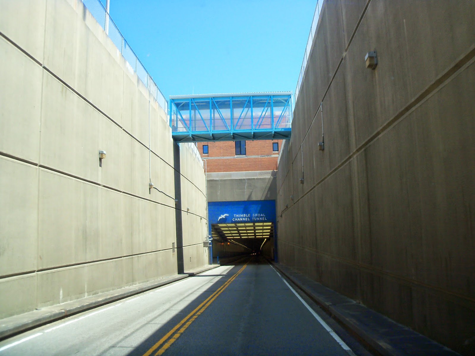
We followed US 13 right onto the Chesapeake Bay Bridge Tunnel. What an engineering marvel! The key features of the Bridge Tunnel are two 1-mile tunnels beneath Thimble Shoals and Chesapeake navigation channels and two pairs of side-by-side high-level bridges over two other navigation channels: North Channel Bridge (75 ft clearance) and Fisherman Inlet Bridge (40 ft clearance). The remaining portion is 12 miles of low-level trestle, 2 miles of causeway, and four man-made islands. The Bridge Tunnel is 17.6 miles long from shore to shore. Including land-approach highways, the overall length is 23 miles long and despite its length. What is more curious is ... there is only a height difference of 6 inches from the south to north end of the bridge–tunnel. The columns that support the bridge–tunnel's trestles are called piles. If placed end to end, the piles would stretch for about 100 miles. Man-made islands, each approximately 5 acres in size, are located at each end of the two tunnels. Between North Channel and Fisherman Inlet, the facility crosses at-grade over Fisherman Island, a barrier island which is part of the Eastern Shore of Virginia National Wildlife Refuge. The Virginia barrier island chain, including Fisherman Island National Wildlife Refuge, is one of only 17 sites in the United States classified as a “Wetland of International Importance.” The Refuge is the southernmost barrier island, located at the mouth of the Chesapeake Bay, and separated from the Eastern Shore of Virginia by about one-half mile of water.
The Refuge is designated at an Important Bird Area and has been growing!! In the late 1800’s it was only 25 acres, compared to today at 2,000 acres!! Because of the critical nature of its habitats for wildlife, Fisherman Island is closed to the public. We continued on US 13 on the DELMARVA pennisula. The peninsula encompasses Virginia, Maryland and Delaware. We found it amazing the number of poultry processing plants along this route.We spent the night at Holly Lakes Campground, it was definitely a very rustic campground. I can honestly say, we have never seen Christmas lights strung through the trees with beer can accents! The campground has over 1,200 sites, but it was quiet mid- week and it was a very restful night! They did have a unique looking goose or duck ...
Research has us believing that it is a  Toulouse goose. It is a large bird, with a ponderous appearance and large dewlaps. The goose generally has a placid disposition, and are better mixed with ducks because more aggressive geese will pick on these breed. They do not need a pond. However, being waterfowl, they love bathing and playing in water and will also mate in water. They are not great wanderers, preferring to stay close to home, making them ideal for this campground location. This goose appeared to be placid and preferred to follow around the smaller ducks as opposed to other geese. Tomorrow we cross to New Jersey on the Cape May-Lewes Ferry. Stay tuned!

Tuesday, June 3, 2014

Heading North Two Lane Adventure - 4th Leg

We spent the whole day on US 17. We left the bumper to bumper non- stop traffic of Myrtle Beach mid morning. We both agreed that all that congested traffic is not for us! We really do appreciate the slower pace of the two lane roads!
We followed part of Washington's Southern Tour. It occurred in the spring of 1791 mostly following the path of current US 17. In order to become acquainted with the American people, to know their hopes and problems, President George Washington decided to tour a section of the United States each year of his presidency. Worshipped as a hero, Washington had been saluted, wined and dined in all major towns he visited in the south. Just off us 17, near Wilmington NC is Moores Creek National Battlefield. This national marker is the site where nearly 1,000 North Carolina Patriots waited quietly with cannons and muskets poised to fire on the unsuspecting Loyalists as they charged across a partially dismantled Moores Creek Bridge on February 27, 1776. This dramatic victory ended British rule in the colony forever.
We saw pink garbage trucks and dumpsters, and wondered what were they about? Pink-Trash was born when INMAN Septic merged with Coastal Ladies Carting to launch Pink-Trash. The Company is New Hanover County’s one-stop-shop solution for Recycling, Trash, Dumpsters, Grease Trap & Septic Tank Services for your home or business. 1% of the billed amounts of their customers are contributed to Pretty in Pink Foundation. This foundation pays for cancer treatment for local women and men. In 2013, contributions paid for over $200,000 in life saving treatment for North Carolinas family, friends and neighbors.
Further up US 17, you cross over the New River. It is a 50-mile long river in southeastern North Carolina that empties into the Atlantic Ocean. My question is we saw the New a River, but what happened to the Old River? Maysville, North Carolina is known as the "Naturally Welcoming" community. It boasts tree lined streets and medians. We can see why they are so friendly! Carefree RV Resorts manages an RV resort in Kissimmee Fl, called Mill Creek, so when we passed Mill Creek Farms I just had to know more! Mill Creek farm is located in Johnston County North Carolina in a low area called Neuse River Islands. The 2,000 acre tract has been privately owned by the Lane family since the 1950’s, originally used simply for timber farming it was all but inaccessible. Russian razorback hogs were introduced to this area by adjoining landowners in the early 1960’s with limited success and only occasionally seen at best. In the 1970-80’s roads were constructed into the property and land was cleared for farming purposes. The Mill Creek Hunt Club came shortly there after as a primarily deer hunting club. Two hurricanes, Fran and Floyd, changed the property forever by displacing many domesticated pigs from farms in the area to this property. The pigs flourished presenting the farm with an uncontrollable number of feral hogs some with very suspicious razorback qualities. If you want to step back in time and find out about a fascinating tale of love, war and the strength of a Southern family. Check out Foscue Plantation, located on the Trent River in Pollockville, North Carolina. Have you ever wondered what southern plantation life was like in the 1800’s? To know what it’s like to share a Thanksgiving dinner where everything on the table came from your own fields and forests? To flee from your home when it’s taken over by unwanted intruders? The tours and history of the Foscoe Plantation can provide all this and more. Built in 1824 by Simon Foscue, Jr., the plantation house has been in the family for nine generations. The décor is high-style ante-bellum and retains a number of original furnishings. In addition, the family has continued to acquire antiques which are correct to the period. Placed on the National Register of Historical Places in 1971, it was one of the first in North Carolina to be designated. US 17 neither begins nor ends in North Carolina. Yet it is the thread that ties together many of the historical and natural wonders of the coastal region. This stretch of highway ties together Wilmington to Elizabeth City, nearly 300 miles to the north. The road has many names that are evocative of its role: the Ocean Highway and the Historic Albemarle Tour Highway to name a couple. Originally, US 17 was intended as the North Carolina segment of Interstate 95. But eastern Carolina politicians, appalled by the idea of an asphalt superhighway cutting through their farmlands, vetoed the idea, and the Interstate was diverted further west. Regardless, millions of people travel US 17 each year. The fact that it is not an interstate is a blessing since many of the gems along the route are fairly well kept secrets. All you need is a tank of gas, a road map, and time to spare, and you can be on your way to discovering the charm and history of eastern Carolina via US 17.