
We spent a day touring the Capitol Reef National Park. Capitol
Reef’s defining geologic feature is a “wrinkle or buckle” in the Earth’s crust.
It extends over 100 miles, from Thousand Lake Mountain to Lake Powell. This “wrinkle
or buckle” is a Waterpocket Fold. Along The Fold, rocks have been pushed upward
and erosion has cut through the layers, creating deep narrow canyons and
interesting formations.

In 1937, President Roosevelt set aside 37,711 acres of the
Capitol Reef area as a National Monument. Two bills were introduced into
Congress in 1970 to determine if Capitol Reef should become a national park.
The Department of Interior officials recommended that 254,000 acres be set
aside as a national park. A year later, the legislation was signed by President
Nixon in December 1971.

It was an eleven mile drive into the park from our
campground. The drive into the park was just as beautiful as what we have seen
already on our adventure!

The first recognizable formation we found was “Chimney Rock.”
It is a 325 foot partially eroded pillar of red sandstone. We headed out early
in the morning, so the light was in the wrong spot to get perfect pictures. We
tried again on our return trip, light was not much better! Did you know that "Chimney Rock" is a popular name ... there are 15 rock formations with this name in the Untied States and Canada. Wow, maybe we need to add seeing all of them to our bucket list!

We drove up to Panorama Point. A foot path from the Panorama
Overlook guided us along the canyon edge where views look down upon layer after
layer of various sandstone formations. Here, the diverse geology of Capitol
Reef National Park is quite evident with layers of reds, tans, browns and whites with trees and shrubs dotting the landscapes.

A short drive, on a gravel road, beyond Panorama Point, is Goosenecks Overlook.
From the parking area, a foot path (of sorts) climbs a ridge where the path
descends to the canyon rim. Carefully pick your way along the rock strewn
trail, because there are few barriers between you and the 800 foot drop to
Sulphur Creek below. From this view, the gooseneck displays strong evidence of
the powerful forces of relentless river currents.

Rick discovered a unique box
canyon here. Our friend, Charlie, said he could imagine the settlers getting
trapped in the box canyon by the Native Americans! We could have gotten closer to the edge of this box Canyon, but I am a big chicken!

We stopped at the Visitor Center and watched the movie on
Capitol Reef. This was the most unique theater, we have seen thus far. It was
bench seating with the screen lower than the seats and a picture window above
the screen. When the movie was ready to start, the curtains closed
automatically darkening the room.

The Gifford farm lies in the heart of the Fruita valley. It
is a green valley among the cliffs of the Waterpocket Fold, offering fruit in
season. The Gifford farmhouse represents the early Mormon settlement of the Fruita valley. The house depicts the typical basic nature of rural Utah farm homes of the early 1900s. It was inhabited by a few families who were about equally good Mormons,
frontiersmen and farmers. Water was carried to the house from the Fremont River and was used untreated.

A two-hole outhouse served the family until an indoor bathroom and plumbing was installed in later years. The homestead includes a barn and coral. Gifford added a kitchen in 1946 and the bathroom, utility
room, and carport in 1954. The house received
electricity in 1948. The Gifford family occupied the home for 41 years, until 1969 and were the last residents of Fruita. Dewey
Gifford sold his home and land to the National Park Service in 1969. With the Giffords' departure, the story of Fruita as a farming community
came to a close.

The Fruita Schoolhouse was were the Gifford children and all
the children in the Fruita Valley attended grade school. Classes had been conducted for two years before the Fruita Schoolhouse was built, in 1896. Even though only eight families lived in Junction, these farmers had large families. One raised thirteen children themselves, one of which, became the first schoolteacher at age twelve. Nettie's first class had 22 students, three of whom were her siblings.

Originally, there was a flat, dirt covered roof on the school. A peaked, shingled roof was added in 1912. The interior walls, originally bare and chinked logs, were plastered in 1935. The first desks were homemade, constructed of pine, and seated two students each. These were sometimes used to quiet unruly students. The teacher would seat a troublesome boy with a girl, and the resulting blow to his ego would often bring him under control.

Behind the school, we
found the boulder with FRUITA GRADE SCHOOL carved into it. Here is a picture from 1935, of the same rock. That is amazing!
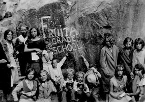 |
| photo courtesy of : NPS.gov |

The Fruita Orchards are still active in growing many
varieties of fruit. In season you can eat all the fruit you want while in the
orchard, but any you want to take out of the orchard you must pay for. The Mule
Deer are common residents in the Fruita orchard area. We were lucky enough to
see one enjoying all the fruit he could, while he was in the orchard! What a perfect picture of this majestic beast!

Down a little ways past the Fruit Schoolhouse, you can see
the Petroglyph Panel on Utah 24. What is a Petroglyph? It is pictures that are carved
or pecked into the rock, they depict people, animals and other shapes and
forms. Human-like figures usually have trapezoidal shaped bodies with arms,
legs and fingers. The figures are often elaborately decorated with headdresses,
ear bobs, necklaces, clothing items and facial expressions.

Abstract designs,
geometric shapes and hand prints are also common. Most are attributed to the
Fremont Culture, which existed in areas of Utah from approximately AD 600 to
1300. The Fremont people were contemporaries of the Ancestral Puebloans(Anasazi) of the Four Corners area.

The meaning of rock art is unknown. Artists
may have recorded religious or mythological events, migrations, hunting trips, travel
routes, and other important knowledge. Look closely at all the pictures to see the details.

Several more rock formations in the park have signs and names.
Including Twin Rocks, which is just as you would expect. Two rock formations
that look exactly the same.

The Egyptian Castle also is another formation that fits its name. It
sits on top of a high rock formation with tall spires all around it and
provides you with a mystical feels of a castle.
The scenic drive is composed of ten stops. Not all stops
have monuments that depict anything, so of the stops help you better understand
the rock formations.

Stop 1 - Most rock at Capitol Reef is sedimentary, formed in
layers from loose materials, like mud and sand. Geologists classify the rock
layers into various formations. Many formations also have different parts, or
members. These layers record the landscapes and lifeforms of a younger planet
Earth. Thin beds of reddish-brown shale were formed from silt and clay that
came to rest in the quiet waters of lagoons, mud flats, and coastal flood
plains. These layers are called the Moenkopi layer. The banded gray and
burgundy layers above the Moenkopi contain volcanic ash, is names as the ChinleFormation.

Stop 2 - The rugged western escarpment of Capitol Reef tells
the essentials of a complex story. Rock bands of differing thickness, colors,
and textures lay one upon another like layers of a cake. The rocks of Capitol
Reef were once sediments laid down in many different environments during the
past. Younger rocks lie on top of older rocks.

Stop 3 - The twisting Grand Wash spur road takes you into a
landscape dramatically different from the dark red hills along the base of
Capitol Reef. Grand Wash is a narrow, steep-walled canyon subject to dangerous
flash floods that often arrive with little warning. We started to turn down it,
but we are in a PT Cruiser, we will skip this turn-off!

Stop 4 - The massive, sheer cliffs of Wingate Sandstone have
far-reaching lines that intercept one another at all angles in the rock. Large
scale crossbedding indicates windswept drifted dunes of an ancient desert. Small
cracks are widened by frost and plant roots. Shallow holes in the cliff are
excavated as water erosion removes more weakly cemented sand grains, leaving
solution pockets and natural bridges.

Stop 5 - Vegetation is more abundant in Grand Wash. Although
relatively bare stone, or slickrock, dominates the landscape here, plants also
are plainly visible. Flash floods can roar down canyons, carrying debris that
crushes and smothers vegetation. Plant life survival requires fulfilling the need
for adequate water and protection from floods.

Stop 6 - The road now
winds through an older, deeper part of the Moenkopi formation. Uniform layers
of sandstone can be seen among the red shale beds, often forming small ledges. The
surfaces of many slabs are covered with ripple marks or mud cracks that formed
when pools of water dried under a hot sun. This formation was laid down by the
gently moving waters of coastal tidal flats.

Stop 7 - Slickrock Divide separates two large drainages. On
either side of this divide, streambeds channel rain runoff and debris into
Grand Wash to the north, and Capitol Gorge to the south. When rain does come to
Capitol Reef, it often descends in torrents. Large expanses of bare rock and
thin patches of soil can do little to absorb and hold it. However, rushing
water shapes this landscape by carrying away material already loosened by
weathering. Gravity draws loosened debris to washes where it is picked up by
moving water. Imagine all the torrents of a plateau converging upon a single
gorge and you will realize how floods develop in a "flash".

Stop 8 - The yellowish-gray Shinarump is a very distinct
member found
intermittently at the base of the Chinle Formation. Shinarump
sediments were laid down in the channels of rivers that meandered across a coastal
plain. Because rivers meander instead of blanketing an area, the Shinaump is
visible only sporadically. Shinarump also contains uranium ore. The old mine
tunnels at the mouth of Grand Wash penetrate the Shinarump. The Oyler Mine used to mine secondary Uranium minerals.

Stop 9 - The Capitol Gorge spur road is longer and more
winding than Grand Wash. Although a through road from 1884 to 1962, the drive
now ends in a few miles. These narrows twist through Wingate Sandstone, the
formation that forms the sheer cliffs along the west face of Capitol Reef and
the towering walls of Grand Wash. Capitol Gorge provides dramatic evidence of
the forces of erosion at Capitol Reef National Park.

Stop 10 - The Navajo Formation, over 1,400 feet thick in
places, caps the upper reaches of Capitol Gorge. Its white, rounded domes,
reminiscent of the nation’s capital building, inspired part of the name for
Capitol Reef. Prospectors with seafaring experience viewed this monocline as a
barrier to transportation, and supplied the nautical term "reef".
Capitol Reef was an awesome place to visit. I is hard to believe
that it was yet again, different than any of the other parks we have visited so
far!
No comments:
Post a Comment