
I have to share with you some hip and trendy things about
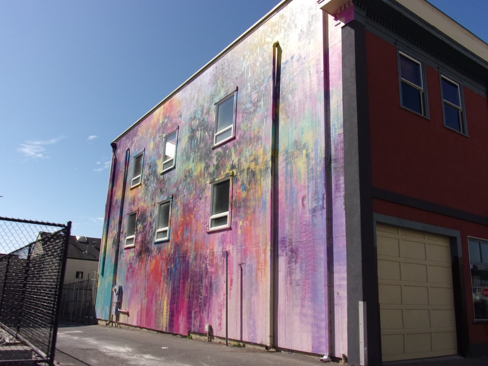
Eureka. Humboldt County is home to hundreds of artists, and this fact is apparent
when one notices the numerous murals that adorn many of the Eureka area
buildings. There are magnificent murals painted on the sides of buildings. Eureka
holds an Art Festival every year in mid-August. Artist work tirelessly to fill
Old Town, with color and creativity. Artist are given 5 days to finish their
murals. Renowned local artist Duane Flatmo has painted many of these, some
humorous and some depicting historical views of the area. Dan Kitchener's mural is on Eureka's Buhne
Building. Called Electric-City is created entirely in freehand spray paint on
the east side of the building. It breaks with the pale masonry of the buildings
around it, conjuring an illusion of deep perspective from a flat brick facade.
Muralist Duncan Jago and Joe Murdter painted the
mural on the De Paul Building, in Eureka. They painted it during the 2017
Eureka Art Festival. The working title is "Monet in space." It is the
simplest way to describe the impressionistic mural that features, abstracted
figures moving through space.

The Coral Sea Research Boat is part of the
Humboldt State University Oceanography Department. Students take classes about
the ocean and then go on a voyage out into the Pacific Ocean. This mural is
titled, Octopus Tsunami Wave.

Artist, Xavi Panneton, got the opportunity to
venture out to a space on the side of the Rodeway Inn building on V Street in
Eureka. The name of this mural is called ‘Living Wall’. He wanted to draw
inspiration from the nature of this area, from the forest and the ocean together.
It’s not really a painting of something specific, more like a mood..

This one is called Animals are People Too. It was
created by Duane Flatmo and Rural Burl Mural Bureau students. It’s a 15-feet-tall-by-80-foot-wide
mural that depicts animal heads on human bodies. It’s a varied collection of
creatures. Some are in suits, one has a top hat, and another brandishes a
guitar.

Duane Flatmo painted the mural on the Eureka CO-OP
store, in downtown Eureka. This mural style reminded me of the mural inside the
Jefferson City capitol building.
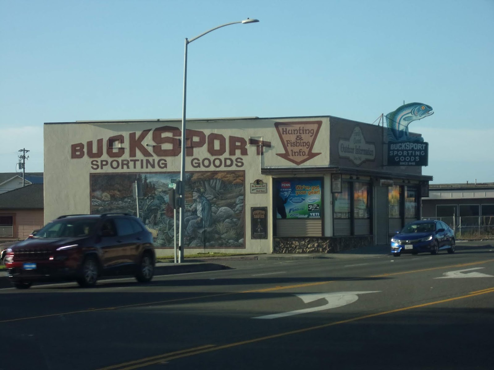
The Bucksport mural is on the side of the
Bucksport Sporting Goods Store. By Duane Flatmo, design by LW Duke. It depicts
rugged mountain men around a campfire, keeping a wary eye on a bear. On the
opposite side of the building are more mountain men in a precarious position
aboard their canoe in raging river rapids.

We departed Shoreline RV Resort via US 101 north. We back
tracked a bit. Outside of Eureka, we picked up Rosann & Paul, from their RV
Park, Crestwood. We all fell in line, for the last time … this trip!
We headed east on CA 299, which is a National Forest Scenic
Byway.

It was a lot of up and up, we hit the Lord Ellis
Summit, 2,267 feet of elevation. Naturally, what goes up must come down …. But,
then we went back up again. To the Berry Summit, at an elevation of 2,803 feet.
It is amazing, considering we started the day at sea level! These elevations do
provide beautiful views!

Six Rivers National Forest is one million acres of
primal recreation area. The Six Rivers National Forest is named for the six
major rivers that run within its boundaries: the Smith, Klamath, Trinity, Mad,
Van Duzen, and Eel. The Smith, Klamath, Trinity, and Eel Rivers comprise over
365 miles of designated Wild and Scenic River. There we go again, with the wild
and scenic waterways …..

President Harry S. Truman established the Six Rivers
National Forest by Presidential proclamation on June 3, 1947. Elevations across
the Forest range from nearly sea-level to approximately 7,000 feet. As a
result, the Six Rivers supports diverse ecosystems and landscapes. The Forest
is composed of extensive stands of coniferous forest, with moderate amounts of
oak woodland and grassland in the southern part of the Forest. These ecosystems
provide habitat for eight federally classified threatened and endangered
species, including the bald eagle and the peregrine falcon.

Willow Creek is a town with a flair for frontier
history. The China Flat Museum is home to the world’s largest collection of Big
Foot curios. Paul is a big fan of Big Foot fan and has the shirt to prove it! Unfortunately,
the museum is not open on Monday and Tuesday. We were able see other forms of
the big guy! He was on a mural on a modern building in town

Out of town, he was on the roof of a building, holding
an American flag. I never knew Big Foot was so patriotic!

The Shasta-Trinity National Forest, the largest in
California, was established by President Theodore Roosevelt’s proclamation of
1905. Initially, there were two forests; the Trinity National Forest
(headquartered in Weaverville) and the Shasta National Forest (headquartered in
Mt. Shasta City). The two forests were combined into one in 1954.

The forest encompasses 2.1 million acres with over
6,278 miles of streams and rivers. It ranges from 1,000 in elevation to the
spectacular Mt. Shasta with its impressive elevation of 14,162 feet. There are five
designated Wilderness Areas: Castle Crags, Chanchellulla, Mount Shasta, Trinity
Alps and Yolla Bolly-Middle Eel. A 154 mile section of the Pacific Crest Trail
runs in an east - west direction across the forest.

The main branch of the Trinity River is a designated
Wild and Scenic River which runs through the forest. Scenic Highway 299 makes
easy access to many points of interest. This major tributary of California's
Klamath River begins in the rugged Trinity Alps and makes its way through
wilderness before meeting up with the mighty Klamath. The Trinity is noted for
its salmon and steelhead fishery resources, as well as its attraction to
rafters, kayakers and canoeists. The North and South Forks of the Trinity and
the New River are included in the designation.

Driving along the Trinity River, on CA 299, we exited
the Shasta-Trinity National Forest and passed through the town of Big Bar. It
was then, that we could see the first signs of past fires.

Along Route 299 you can view the La Grange Mine
Markers. This mine was originally known as the Oregon Mountain group of claims,
first operated about 1862. In 1892 the mine was purchased by the La Grange
Hydraulic Gold Mining Company which brought water from Stuart's Fork through 29
miles of ditch tunnels and flumes, then delivered it to the mine pit under a
650 food head. Over 100,000,000 yards of gravel were moved and $3,500,000 in
gold produced. Large scale operations ceased in 1918.

The blight left by Carr Fire will overshadow the
areas surrounding Redding, California, long after the smoke fades.

Following Highway 299 for a while, and watched the path
of the grass fire that spread to more than 100,000 acres, destroyed more than
1,000 structures and killed at least six people.

We had a section of one way traffic, with a pilot
car. This is to allow the workers to repair the road and clear trees, etc away
from the road. They are chipping the trees and putting them over the edge on
the south side of the road and using a hydro-seeder on the dirt walls on the
north side of the road.

It began with a flat tire, officials say, with a
rim-riding trailer scraping the road and summoning sparks by Carr Powerhouse
Road near Whiskeytown Lake. Contagious in the hot, dry brush, it grew.

From there, the blaze snaked west to east along
Highway 299.

A large portion of Whiskeytown National Recreation
Area is gone, just gone.

Whiskeytown Lake was a great source of water for the
Carr Fire suppression. It was also a great place to moor the vessels and keep
them safe from the fire.

We had a second stop near the historic town of Shasta.
We talked to the flag lady as we waited for the pilot car. We asked her for a
good place to eat and a place to park the three coaches. She recommended a Mexican
place, just into Redding.

From mining towns to half-million-dollar homes, the
Carr Fire conjured waves and tornadoes of flames, painting a wake of
devastation in black embers and white ash.

Along every mile, from the west edge of Whiskeytown
Lake to the outskirts of Redding, it caught the vulnerable by surprise.

Arriving in Redding, we could see just how close the
fire got. The signs thank the firefighters and vow to rebuild!

So, we had our final lunch as a group, at Puerta Vallarta.
We enjoyed the meal and the comradery of our group!


The girls enjoyed margaritas and the boys
had non-alcoholic beverages!

We said our “see you laters” and went on our separate
ways!
No comments:
Post a Comment