
We departed Bordertown Casino & RV Resort, no richer,
but no poorer either. I guess that is the goal, when you go to a casino … if
you can’t win, don’t lose! I looked for a sign that welcomed us to Nevada, none
found!

We got back on US 395 and took it to I-80, where we skirted
around Reno, Nevada. Reno began as the preferred crossing point of the Truckee
River, for travelers on their way to the California gold rush of the late
1840's. With the discovery of the Comstock Lode in the nearby Virginia City
foothills in 1859, the river crossing became increasingly important for the
growing trade in mining and agriculture. Reno was officially established in
1868, the same year that the transcontinental railroad, which paralleled the
Truckee River, reached the town. In 1874, the University of Nevada was founded
as a land-grant university, and in 1885, the primary campus was built on a rise
of land overlooking Reno from the north.

From its inception, the university was
an integral component of the young town’s identity and contributed to Reno’s
reputation as a cultural center. This was reflected in Reno’s nickname,
“Biggest Little City in the World,” which arose as a result of the wide range
of cosmopolitan amenities in a city of its relatively small size. In 1931, Nevada legalized gambling. Reno was a front
runner in creating the model of destination hotel and casino gaming, a model
which has been replicated throughout the world. The transcontinental Lincoln
Highway, passed through the heart of downtown and many motor lodges sprang up
on either side of the Virginia Street core to support booming post-war
automobile tourism. For most of the 20th century, tourism and the gaming and
entertainment industries formed the backbone of Reno’s economy.

We traveled 30-miles on I-80. It is an east-west
interstate that runs over 400 miles across Nevada. It traverses mountains and
valleys, thank God we only had to take it from Reno to Fernley. I know why I
dislike Interstates, bump, bump, bump …. For 30-miles! We got off at exit 48 toward
US 50.

We are entering Pony Express Territory, from April of
1860 to October of 1861, dozens of brave Pony Express riders delivered mail
between Sacramento, California and St Joseph, Missouri. A distance of 2,000
miles, and it took Pony Express riders ten days, which was half the time the
stagecoach required for the same journey. By keeping the east connected with
the west, the Pony Express held the nation together. Young Pony Express riders
charged across the country on the fastest horses available. Over two thousand
miles of wilderness was crossed, including a section of high mountain desert in
Nevada. Today, this stretch of Nevada has been designated “Pony Express
Territory.” It is a 17-million acre museum, where visitors can experience
nature, history, art and science. Undisturbed and one of a kind, their doors
are always open in Pony Express Territory and there are no waiting lines. The
Loneliest Road roughly parallels the Pony Express Trail, which goes from Silver
Springs through Fallon and along the towns across Highway 50. Remnants of Pony
Express Stations are visible for much of the way along the Loneliest Road.

We followed Alternate US 50 E for just a little bit,
we were soon getting onto US 50 E and entering Fallon, Nevada. Fallon was named
after Mike Fallon, born in Ireland in 1849. Fallon was a Union Army drummer boy
in one of John Fremont's units. In 1853, Fallon settled in Forestville, CA with
his wife Eliza Bruner where they had four children. In about 1896, Fallon
traded his land in Forestville for an alfalfa ranch in Stillwater near present
day Fallon. His ranch home was located at a well-traveled crossroads to
Stillwater and surrounding areas. This was the logical site for a post office
and a small store and soon became the community we know today as Fallon. Fallon
was a major agricultural region famous for its “Hearts O Gold” cantaloupes. Cantaloupe
was shipped to all of the finest restaurants in the country. For 15 years, the
Lahontan Valley is known as the "King of Cantaloupe." Hybrids
developed in the Imperial Valley in California soon replaced the Heart of Gold
and farmers turned back to growing alfalfa. Today, warm weather and altitude
combine to produce high protein alfalfa that is exported to California and
Japan.

In 1942, following the attack on Pearl Harbor, one of
four airfields built for our nation's air defense in the Nevada desert was
constructed in Fallon. As the war in the Pacific escalated, the facility in
Fallon was utilized as a Naval Auxiliary Air Station to train torpedo, attack
and fighter pilots for action. The airfields at NAS Fallon were named for
Nevada's only Congressional Medal of Honor winner, Bruce Avery Van Voorhis, who
gave up his life in a mission against the Japanese.

Known throughout the Navy as the only facility in
existence where an entire carrier air wing can conduct comprehensive training
while integrating every element of the wing into realistic battle scenarios.
Fallon enjoys more than 300 clear flying days per year and gets the most out of
each of those days with its four bombing ranges, the electronic warfare range
and all of its other excellent training facilities. The 14,000-foot runway
remains the longest in the Navy, making Fallon a one-stop training facility
unequaled throughout the service. We were lucky enough to see 2 of the jets
take off, but they don’t stay visible long! Look close and you can see him!

In July 1986, Life magazine described Nevada’s US Highway
50 from Fernley to Ely as the “Loneliest Road in America.” Life said there were
no attractions or points of interest along the 287-mile stretch of road and
recommended that drivers have “survival skills” to travel the route. Highway 50
has its ups and downs, literally. The highway crosses nine mountain ranges,
most over 10,000 feet. Highway 50 is wide and open, but also scenic and
historic corridors. It retraces the route of the Pony Express and Overland
Stagecoach trails and passes through some of the best-preserved 19th century
mining towns in the state. It is seemingly untouched by man. Real emptiness
begins soon after Fallon.

From Fallon, US 50 passes through extensive salt
flats with areas of sand dunes for much of the next 50 miles east, until the
approach of the Clan Alpine Mountains, the first of many north-aligned ranges
between here and the Utah border.


Some travelers stopped on the loneliest road
to write a message in rocks, along the edge of the salt flats! Charlie & I
were not that bored yet, to do that! Not sure what we would write anyway! Here after
the road passes through only three towns of any significance - Austin, Eureka
and Ely, separated by 111, 70 and 77 miles respectively.

If you follow my blogs, you know how obsessed I am
with road crossing signs! Well, we found another new one to add to the list … a
Bull Crossing Sign. Yes, that is a bull, he has horns! I am thinking that it
might be a bit more unique than the pea fowl or turtle crossing signs.

Sand Mountain dominates the Salt Wells Basin and is
visible from Mt. Rose peak in the Carson Range 82 miles to the west. The dune
is important to off highway vehicle enthusiasts, biologists, Native Americans,
and geologists. It was created by the
windblown sand from the beaches of the prehistoric sea that once covered
Nevada. The Sand Mountain blue butterfly is only found here where it is depends
on the Kearney buckwheat plant. The dunes clearly marked the location of nearby
Sand Springs, improved and mapped in 1859 as a potential emigrant stop by Army
Lieutenant James H. Simpson. Sand Springs later served as the location of the
Sand Springs Pony Express Station in 1860 and the terminus of the 1866 Fort
Churchill and Sand Springs Toll Road.

We saw a B-17 Naval Range, in the middle of the
loneliest road. The Fallon Range Training Complex encompasses over 234,124
acres of land area including the B-16, B-17, B-19, B-20, Dixie Valley, and
Shoal Site training areas. Okay, so maybe the B-17 was just the number of the
range … not what is flown on it! We saw small targets and it made us think of
our brother-in-law Mike, he ran a military bombing range in New Jersey.

Alongside a stretch of the historic Lincoln highway,
U.S. Route 50, dubbed the Loneliest Road in America, is an isolated Wild
West-style saloon announced by a wooden sign that (accurately) describes its
location as “in the middle of nowhere.” Founded in 1857 by James Simpson, the
restaurant that stands today was once an active station and rest stop along the
historic Pony Express Trail, serving horses and their riders alike. Due to its
location between two gate-like cuts in the mountains—known as Eastgate and
Westgate—this station became known as Middlegate Station. When the Pony Express ceased operations in October of 1861,
Middlegate Station remained open, serving as a stage and freight stop for gold
and silver mines. Ever since, it has survived as the only gas station for
nearly 50 miles in both directions and a rare roadside eatery along the Lincoln
Highway.

The one thing I wanted to see on this stretch of road
was the “Shoe Tree.” You would think that with a whole lot of nothing on this
road, I could spot a tree full of shoes! Nope, no such luck! My directions told
us to drive east out of Fallon, along HWY 50. Tree is on the North side of the
highway between Middlegate and Cold Springs. Well, there really are not that
many trees …. This is the only one I found in that area! I did learn that on
December 30, 2011, the shoe tree was cut down by vandals. However, by 2017 the
locals have designated a tree nearby as the new shoe tree, and they say it is already
decorated with an impressive number of shoes. Not that I can confirm that fact!

Rock Creek was an important stagecoach stop on the
Overland Mail & Stage Company’s historic line along the Simpson route
between Salt Lake City and Genoa, Nevada, which was operated by John
Butterfield and later Wells, Fargo & Company. Fresh horses, blacksmith services, and
wagon-repair facilities were available here. The Pony Express constructed the
Cold Springs station in 1860 on the sagebrush bench eastward across the
highway. To the north are the ruins of a telegraph repeater and maintenance
station which serviced this segment of the transcontinental line, which was
completed between Sacramento and Omaha in 1861.
The line was abandoned in August 1869.
The coming of the transcontinental railroad and its parallel telegraph
line along the Humboldt River to the north spelled the demise of both the
telegraph line and the stage route here.

The rocks composing the walls of this stage station
and freighter stop were in neat array and roofed with bundles of willow twigs
in July 1861, when John Butterfield’s Overland Mail & Stage Company began
traversing this Central Route between Salt Lake City and Genoa, Nevada. The
spring on the hill was inadequate for both humans and horses. However, Division Superintendent Thomas
Plain’s support ranch, one mile to the west, kept this important team-watering
and replacement-stop operating. Completion of the first transcontinental
railroad spelled the eventual demise of the Overland Stage line. Butterfield sold out to Wells, Fargo &
Company in 1866, which suspended all operations on the Central Route in
February 1869. The company continued to
operate their diverted equipment on other lines until the early 1870s.

The town of Austin was our original destination for the
night, but the two campgrounds in the town were full. So onward we go! Austin, is
another former mining town. Austin sprang into being after William Talcott
discovered silver at this spot on May 2, 1862.
Talcott came from Jacobsville, a stage stop six miles to the west on the
Reese River. He was hauling wood out of Pony Canyon, directly below, when he
made the strike that set off the famous “Rush to Reese.” A town called Clifton
flourished briefly in Pony Canyon but fast growing Austin soon took over and
became the Lander County seat in 1863. Before the mines began to fail in the
1880s Austin was a substantial city of several thousand people. From Austin, prospectors fanned out to open
many other important mining camps in the Great Basin.
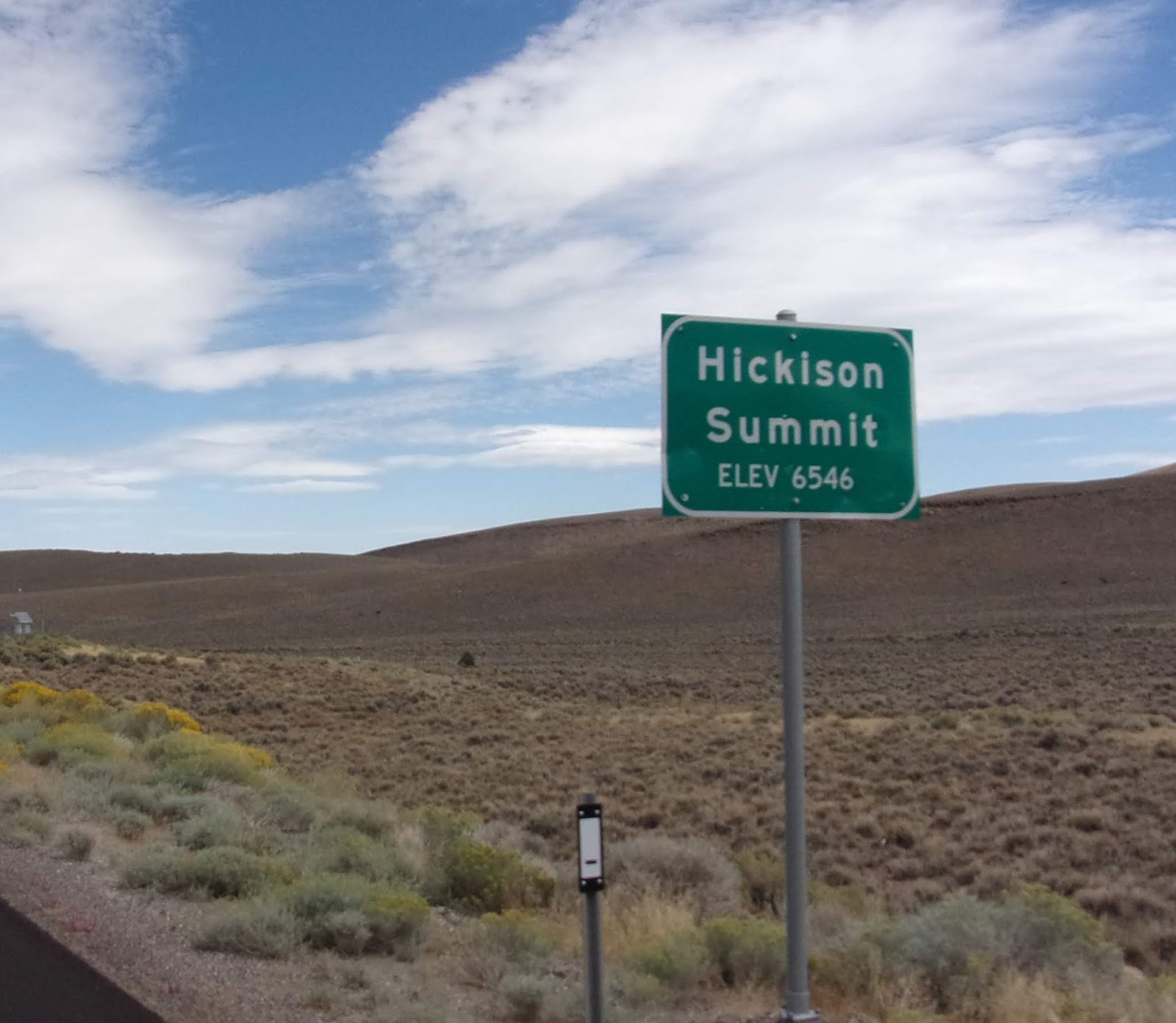
The Hickison Summit sits at an elevation of 6,594. The
summit was named after rancher John Hickison because the road to his ranch
passed over the summit. About one mile
northwest lies Hickison Summit, a natural pass between two low buttes. Passes
and canyons were common Native American hunting locations for funneling and
ambushing bighorn sheep and deer herds. Archaeological sites in the region
reveal a dominance of bighorn bones and horn, reflecting the bighorn’s
importance to Native Americans as food and raw material for tool
production. The bighorn lacked
resistance to diseases introduced by domestic sheep in the nineteenth century,
and this resulted in catastrophic bighorn population declines throughout the
West. Prehistoric Native American petroglyphs, images and designs are carved
into rock surfaces, and are interpreted along a short hiking trail.
Archaeologists hypothesize that the meanings for these designs include
ceremonial, female puberty markers; ritual hunting magic symbols; and rock art
or simply graffiti.

We arrived in Eureka, only 77 more miles to go to
reach Ely! Eureka is perhaps the best preserved example of a 19th century
mining town in the state. There are beautifully restored historic buildings and
authentic frontier cemeteries in Eureka. A story about Eureka, Charlie’s cousin
Frank (who we will visit in Grand Junction CO), messaged me about him and Charlie
doing some jobs in Eureka. Before I could read the message to Charlie, he said
that he worked a couple surveying jobs in Eureka with Frank. Funny how our
minds work and what triggers a memory!

The Eureka Opera House was built on the ashes of the
Odd Fellows Hall, destroyed by the great main street fire of August 1879. The
Opera House was used for the first time for the New Year’s Eve Costume Ball in
1880. The Opera House has always served as a gathering place for the people of
Eureka. It has been the site of entertainment of all types as well as the
annual Nob Hill Fire Company Masquerade Ball held every year from 1880 until
well into the 1900's. The first silent movie was shown in 1915 and then in the
1920s the opera house was changed into the Eureka Theatre and talkie shows were
presented. In 1923 the original oleo curtain on the stage was destroyed by fire
and was then replaced with the curtain with advertisements from local businesses
from 1924. The last movie was shown in 1958 and the building had fallen into
disrepair. In 1990 Eureka County acquired the structure and began a three year
restoration. The building received the 1994 National Preservation Honor Award
after being reopened on October 5, 1993. Today the Eureka Opera House is a full
service convention center and Cultural Arts Center. The building is used for
conventions, meetings, and community functions as well as cultural
presentations.

More ups and downs … into the valleys

and over another summit, or two or three ... eleven to be exact!

We arrived in Ely, Nevada … Our home for 2 nights! Ely
is a historic copper mining town. It is also home to the Nevada Northern
Railway Museum, one of the best preserved short line railroads in the county. I
will share more about Ely with you tomorrow!

(9163) Traveling on the Loneliest Road we were well rewarded
by the almost surrealistic intensity of the wild western landscape. We saw deep
blue skies and jagged stone towering above the desert floor. The hypnotic
rhythm of telephone poles marching in single file as a solemn procession beside
the road. So far, the Loneliest Road in America, Highway 50 is really not so
lonely, but one of the most beautiful and interesting Two Lane Roads we have driven in a while.
We have more of it to travel when we leave Ely too!
No comments:
Post a Comment