 Today is another long day for us … close to 300
miles. We are traveling from Amarillo Texas to Shawnee Oklahoma. We spent one
night at the Amarillo Ranch RV Resort or was it the Big Texan RV Ranch? We
learned that in May 2015, Bobby and Danny Lee, owners of the Big Texan
Restaurant, acquired the 24-acre Amarillo Ranch RV Park from the Sam Hill.
Today is another long day for us … close to 300
miles. We are traveling from Amarillo Texas to Shawnee Oklahoma. We spent one
night at the Amarillo Ranch RV Resort or was it the Big Texan RV Ranch? We
learned that in May 2015, Bobby and Danny Lee, owners of the Big Texan
Restaurant, acquired the 24-acre Amarillo Ranch RV Park from the Sam Hill.

To the east of this park is the Starlight Ranch Event
Center, which the Big Texan’s owners opened in May 2017. The restaurant has
acquired land to develop a themed tourist hub around the new location,
including the current RV park, hotels, retail space and an indoor water park.

As we departed, there was a beautiful red sky, never
mind all of the illuminated signs. Just enjoy the red sky. Because, by the time
we got away from the signs, the red sky was gone!

We were traveling on Interstate 40 E again. We have
seen several Triple X signs, but never an X X X rated grain elevators!

The wind turbines we saw today looked like they were
placed in a straight line! At one point it looked like we were going to drive
right into them, but I missed capturing a picture of that!

Roadside America calls this place, Stoner Patriot
Peace Garden, a contemplative outdoor space with an inclusive mix of patriotic,
religious, and stoner icons. Although there are no flowers, it is a garden of
signs for all faiths.

It is the brainchild of a Richard Daniel Baker, a
local farmer, retired telephone repairman, philanthropist, a dreamer and a
veteran. It is a many signs of dates, quotes, and inclusive thoughts that seem
haphazardly placed in this west Texas garden.
However, when viewed from above, they form, another peace sign.

In Groom Texas there is a big cross and round church at
exit 112. It is officially called "The Cross of Our Lord Jesus Christ."
It stands 19 stories tall in a landscape that is as flat as unleavened bread
and as empty as Jesus's Tomb. I-40 follows the path of old Route 66 and the
Mother Road's legacy of rope-'em-in salesmanship wasn't lost on the Texas
millionaire who bankrolled the Cross. It's more than just a 2.5-million-pound
steel hallelujah. It's also a heaven-scraping billboard, luring travelers to
other Christian shrines arrayed within its long shadow.
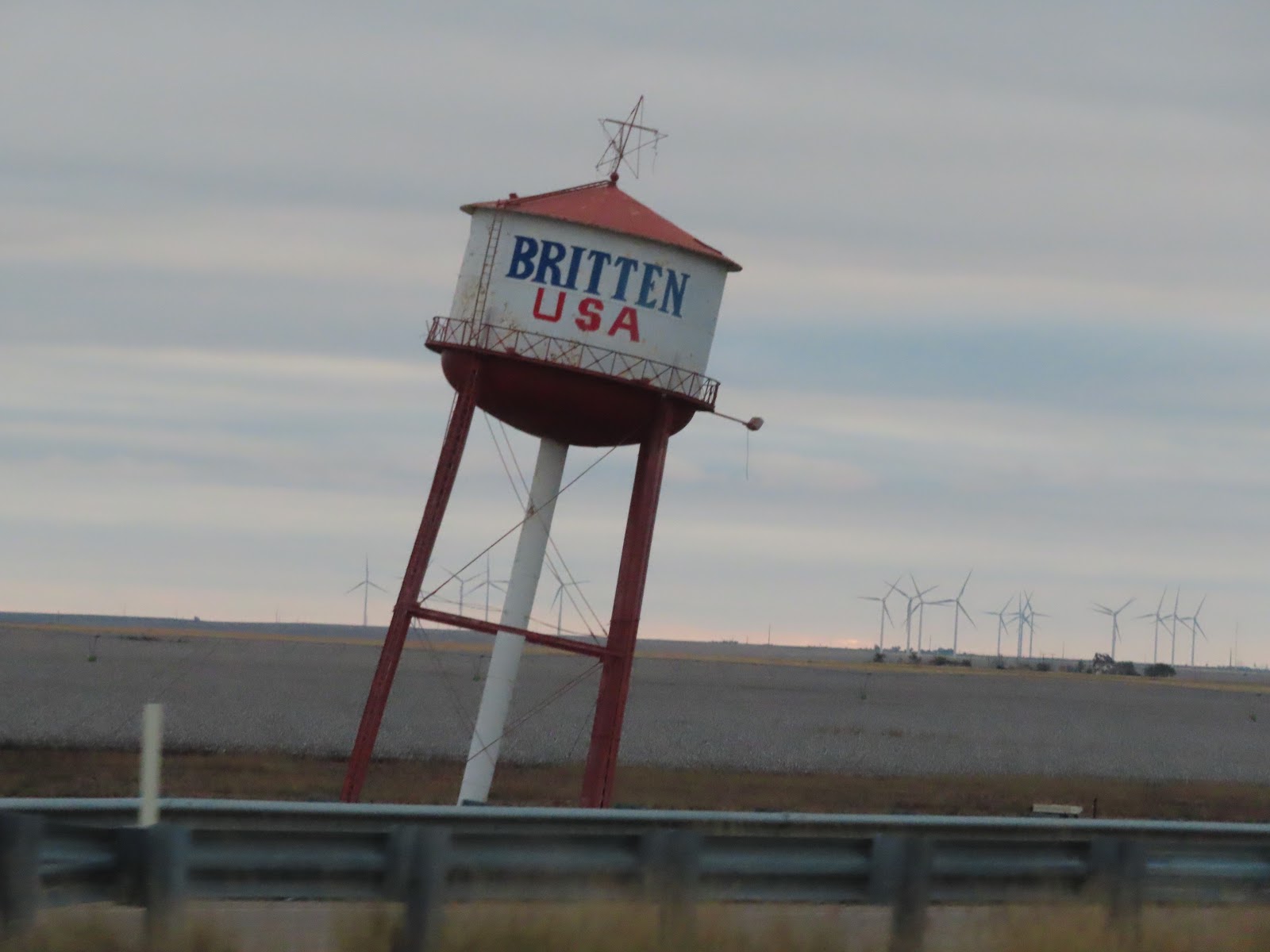
Before that big cross, Groom Texas’s prime attraction
was the old water tower. It wasn't exceptionally tall, yet, travelers
worshiped it all the same because it leaned to the side, a little. Some
thought it was nearly toppled by a clumsy aviator, while others chalked it up
to a passing tornado. The more imaginative placed blame on a senior prank.
Naturally, these were all just rumors and entirely unsubstantiated. The lean was deliberate, it worked like a
charm, too. Passing motorists pulled off the highway just to make sure they saw
what they thought they saw. Next thing they knew, they were finding themselves
in the parking lot of Ralph Britten's truck stop and restaurant. Originally, the tower was meant
to serve simply as the business's water supply. Around 1980, Ralph Britten
purchased it from the nearby town and transported it, in one piece, to Groom.
Finding a simpler solution for water storage, however, he decided instead to
employ the tower as an attention-getter. Britten and his crew, using only a
bulldozer to lift the massive tank into place, buried one side partway in the
ground and set the whole thing at an 80-degree angle, give or take. The tower
stands today as it did then … no anchors, no concrete, no guide wires. It's
just balanced there, two of its legs dangling mid-air.

I never knew that cotton was a TX crop. But, it is! Cotton,
wheat, and grain sorghum are the principal crops produced in the Texas
Panhandle. The cotton growing area represents a portion of two cotton
production regions, that of the Rolling Plains and the eastern portion of the
Trans-Pecos Region. The Rolling Plains may be the last to harvest since cotton
may be planted there as late as June 20 to achieve a normal harvest. Cotton
harvest will commence there in mid to late October or maybe as late as
November. That explains why, it was not harvested yet!

We left early enough today that we finally started to
see the sunrise on the horizon.

It was uneventful as we passed over the Texas and
Oklahoma state line. There was a stone “Oklahoma” sign, but not much else. The
good news about Oklahoma, is the gas prices are better than we have had in a
while.

Charlie’s favorite bologna has a distribution center
in Elk City Oklahoma, Bar S Foods. Too bad, we don’t have any cinnamon rolls ….
Yum, yum!

Never knew that General Tommy Franks had a Leadership Institute
and Museum in Oklahoma. It was created by General Tommy Franks and his wife,
Cathryn. It is foundation dedicated to telling the story of the United States Military
and to educate. The institute invests in the nation's future leaders through
several education and outreach programs including the Mobile Classroom and Road
Show, the Inspired Leadership Challenge and the Four Star Leadership with
General Tommy Franks program.
 The world-class Museum is housed in a remodeled,
9,500-square-foot building in downtown Hobart, Oklahoma. Exhibitions are
ordered chronologically, following General Tommy Franks life and career, while
also showcasing the changes in the American military from WWII to the present,
as told through the lives of soldiers.
The world-class Museum is housed in a remodeled,
9,500-square-foot building in downtown Hobart, Oklahoma. Exhibitions are
ordered chronologically, following General Tommy Franks life and career, while
also showcasing the changes in the American military from WWII to the present,
as told through the lives of soldiers.
I am a firm believer in clean energy and I love to see
new wind turbines going up. We have seen our share this trip, right, Nancy Ragland?!

The Canadian River, the largest tributary of the
Arkansas River, rises in the Sangre de Cristo Mountains in southern Colorado
and flows south and southeastward. According to some sources, the river's name
came from early explorers who thought that it flowed into Canada. It is roughly
760 miles long with a stretch of about 190 miles is in Texas. The river is
dammed to form the Conchas and Ute reservoirs in northeastern New Mexico before
it enters Texas. The Canadian crosses the Panhandle, flowing eastward and northeastward.
Most of the river's course across the Panhandle passes through a gorge 500 to
800 feet below the plateau. Particularly in its lower reaches in Oklahoma, the
riverbed contains great amounts of quicksand. This and the deep gorge make the
river difficult to bridge.

We found a Natural Gas collection site near mile
marker 118 on Interstate 40, between Groom and Yukon. Charlie was wondering if
it was a Williams Energy site. Do you know Don & Linda? Well anyway, it
made us think of you and smile!

The railway company laid its track through Yukon in 1891, causing the abandonment of the nearby town of Frisco. Situated in proximity to fertile farmland, Yukon quickly thrived as the urban center for area farmers. Beginning in about 1898 Yukon began attracting a size-able Bohemian population. Following World War I and the dissolution of Bohemia into Czechoslovakia, the Yukon Bohemians became "Czechs." This heritage is still recognized today. Yukon has been proclaimed "the Czech Capital of Oklahoma" and since 1966 has held an annual Czech Day in October. A tangible reminder of the Czech presence is the historic Jan Zizka Lodge Number 67, popularly known as Czech Hall. Not sure who is more popular the Czechs or Garth Brooks, they both call Yukon home!

In Oklahoma City, there was a very interesting sculpture
over expressway. I learned that in conjunction with the southern relocation of
a portion of I-40 near downtown, the city also constructed the Skydance
Pedestrian Bridge. It is a visually stunning addition that allows foot traffic
to freely cross this highly-congested area of the interstate highway. Construction
of the Skydance Pedestrian Bridge began in August 2011, just as the I-40
construction entered final stages. The estimated $6.6 million construction cost
was funded by both city and federal money, about $3.5 million coming from the
Oklahoma State Department of Transportation's federal funding and the rest from
the city of Oklahoma City. The Skydance Pedestrian Bridge design is said to be
inspired by the "sky dance" of the scissor-tailed flycatcher,
Oklahoma's state bird. The 18-story structure is 30-feet wide and stretches
440-feet across the semi-depressed section of the 10-lane I-40 south of
downtown. Wings rise above the bridge, reaching as high as 185 feet in the air,
and a 66-inch high ornamental metal railing spans the length of the bridge. The
bridge is made of stainless steel panels that shimmer in the sun, and the
wings, made from a translucent material, appear to glow from within, creating a
stunning visual display

Tinker Air Force Base is southeast of downtown Oklahoma City.
It is one of the largest and most important military installations in the US. It
covers more than five thousand acres, boasts two ten-thousand-foot runways, is
home to seven thousand military personnel, and fifteen thousand civilian
employees. The base is home to the Oklahoma City Air Logistics Center, 552d Air
Control Wing, 507th Air Refueling Wing, 513th Air Control Group, Navy Strategic
Communications Wing One, Defense Logistics Agency's Defense Distribution Depot
Oklahoma City, Third Combat Communications Group, Thirty-eighth Engineering
Installation Group, and Defense Megacenter Oklahoma City. The air base was
named for Maj. Gen. Clarence L. Tinker, a one-eighth Osage from Pawhuska,
Oklahoma, who lost his life in the Pacific while leading a flight of LB-30s on
a bombing strike against the Japanese in June 1942.

We arrived in Shawnee Oklahoma at the Heart of Oklahoma Expo
Center, location of the Oklahoma Good Sam Rally and our home for the next three
nights.
No comments:
Post a Comment