
We departed the Texarkana KOA on US 93 south, working
our way back onto US 82 East. It is another dreary rainy morning to travel.

Texas High School had the biggest American and Texas
flags I have ever seen at a High School.

We crossed into Arkansas by crossing State Line Ave. State
Line Ave is what separates Texas and Arkansas. As we crossed State Line Avenue,
there was a War Memorial in the center median. Five flagpoles fly the United
States flag, the POW/MIA flag, the Arkansas flag, the Louisiana flag, the
Oklahoma flag, and the Texas flag. In early 1983, some of our city's leaders in
Texarkana came up with the idea to honor veterans from the Korean and Vietnam
Wars from the Four States Area immediately surrounding Texarkana. Because of
different reasons, they floundered with this idea for almost four years, before
letting it die a slow death. In April 1987, Vietnam Veterans of America chapter
#278, approached these leaders and asked if they could take over where they had
left off. After several months of largely unsuccessful fundraising events, they
decided we needed to show the area they meant to build this memorial. Way short
of the fundraising goal, they held the groundbreaking ceremony on July 25,
1988. It worked - funds and material donations started coming in. A local
government contractor set the ball in motion with a donation of $5,000. After
several months of hot, hard work, shedding blood, sweat, and tears, it came
together. Even though they said it could not be done, on November 12, 1988, they
dedicated the Korean/Vietnam Memorial in Texarkana.

Magnolia is home to Southern Arkansas University
Campus. Southern Arkansas University is a public university. It was founded in
1909 as the Third District Agricultural School (TDAS). The school was later
elevated to a junior college, Magnolia A&M, in 1925, and a four-year
college, Southern State College, in 1951. Renamed Southern Arkansas University
in 1976, the University has grown to host over 4,000 students, serving as an
educational cornerstone of the Magnolia community and Southwest Arkansas.

The Farmers Bank and Trust Reception Center and the
Story Arena are unique components of Southern Arkansas University. The Story
Arena is a multipurpose, covered arena located on US 82, west of the Mulerider
Stables. The facility is a 78,000 square foot covered rodeo-style arena with a
dirt floor and seating for approximately 1,400. The Farmers Bank and Trust is the
7,500 square foot reception area that sits in front of the arena.

There was a huuuuuge Tuscan Style Mansion outside of
Magnolia on US 82. I could not find out anything about the home or the owner,
but it was an awesome looking home! Too big for us … you have to clean all
those rooms!

The welcome sign for El Dorado, claims it is Arkansas
original Boomtown. El Dorado is Spanish for the gilded one. Matthew F. Rainey
became the first resident of El Dorado by accident. Rainey’s wagon broke down
there in 1843, and being unable to get replacement parts, he held a sale of his
possessions. The sale went so well that he bought more goods and opened a
store. It is not known if Rainey was responsible for naming his new home in
recognition of his good fortune.

We don’t know her story either …. But, we saw this
lady walking her mule along the side of US 82 on the edge of El Dorado,
Arkansas.

The town of Crossett was named after Edward S.
Crossett, a leading entrepreneur in the lumber industry's emergence in
Arkansas. In May 1899, Crossett joined with three partners to form the Crossett
Lumber Company, which then sought to build a lumber mill in the town of
Hamburg. Displeased with the reception the proposed mill was receiving there,
the company selected a site in the forest about 12 miles southeast of Hamburg,
where Crossett was born as a tent city constructing the company's mill. Lumber
from initial milling operations was used to build a permanent mill, company
offices and employee housing. Crossett remained a classic "mill town"
into the mid-1940s with Crossett Lumber owning all the town's homes and
businesses until 1946. Though some early lumber towns were abandoned when the
supply of harvestable trees was exhausted, Crossett's future was secured
through improved forest management practices and through the manufacture of
diverse forest-related products, including wood alcohol, turpentine, chemicals
needed by soap and paint manufacturers, charcoal, food board and flakeboard.

Ouachita River comes from the Ouachita Mountains of
west-central Arkansas. It flows in a generally southeasterly direction to join
the Red River in Louisiana after flowing for over 600 miles. The Ouachita has
been a navigation route since the late 18th century. Six locks and dams were
built on the river prior to 1924. There are three multipurpose dams
(hydropower, flood control, recreational facilities) on the upper Ouachita
within the Ouachita Mountains: Blakely Mountain and Carpenter dams near Hot
Springs National Park, impounding Lakes Ouachita and Hamilton, and Remmel Dam,
impounding Lake Catherine.

In 2011, Hamburg was designated a Preserve America
Community. The town was created in 1849. Two of the first public buildings were
built the next year, the courthouse and the county jail. During the Civil War,
the town provided troops to the Confederacy and several companies of the Third
Arkansas Infantry that fought with the Army of Northern Virginia, commanded by
Hamburg lawyer Van H. Manning. The town escaped military action during the war,
though Union troops briefly occupied it during Reconstruction. The city’s
economy was divided among agriculture and forestry due to the town’s geographic
location. Immediately east and west are prairie regions dedicated to rice and
soybean culture.
A few miles east, cotton reigns in the Mississippi Delta. On
the north and the south, timber is plentiful. Through the early 1900s,
agriculture dominated though lumber production became important in later years.
After the Depression, social shifts occurred when farmers gave up attempts to
live off their land. Many left the region or went to work in sawmills or paper
mills. These days, the downtown square, with its gazebo, now serves as
home-base to the annual Armadillo Festival, held the first weekend in May since
1970.
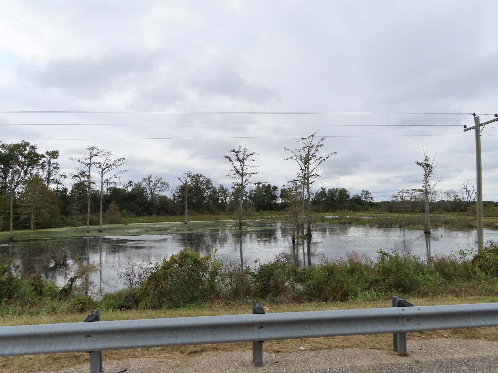
I took this picture and loved the reflection. I am
calling it the “Arkansas Bayou.”

There are many Cat Fish Farms on Hwy 82 near Lake
Village. I learned they feed the fish a soybean grain mixture to stop them from
seeking food elsewhere in the ponds. Many politicians and entrepreneurs hoped
catfish in the Mississippi Delta could become what chicken is in the Ozarks.
That was before Vietnamese and Chinese fish flooded the American market. Today
there are about a third the number of catfish farms there were in 2000, and
they are making about half as much money. According to the United States
Department of Agriculture, in 1998, 156 Arkansas catfish farms produced sales
valued at more than $55 million. In 2013, 49 farms made more than $28 million.

Lake Village is located along the Great River Road
National Scenic Byway and lies on the "C" shaped curving shore of
picturesque Lake Chicot, a 20-mile long abandoned channel of the Mississippi
River that is Arkansas's largest natural lake. Lake Chicot State Park offers
cabins, campgrounds, a marina and other recreational assets. The downtown Jack
R Rhodes Lakefront Park provides a community swimming area, walking path, small
amphitheater, boat ramp and picnic pavilions.

Just before the Arkansas and Mississippi border, we
crossed over the Mississippi River. The Mississippi River is one of the world’s
major river systems in size and habitat. It is also one of the world's most
important commercial waterways and one of North America's great migration
routes for both birds and fishes. Native Americans lived along its banks and
used the river for sustenance and transportation. Early European explorers used
the Mississippi to explore the interior and the northern reaches of what was to
become the US. Fur traders plied their trade on the river and soldiers of
several nations garrisoned troops at strategic points, at various times, along
the river when the area was still on the frontier. White settlers from Europe
and the US arrived on steamboats displacing the Native Americans of their lands
and converting the landscape into farms and cities.

We crossed from Arkansas to Mississippi. The
Mississippi welcome sign boasts they are the “birthplace of America’s Music.” The
University of Mississippi Blues Archive contains the world’s largest collection
of blues music. The Mississippi Delta is the birthplace of Blues music, the
only music recognized as truly original to America. The Mississippi Blues
Trail, a virtual trail with markers throughout the state and beyond.

In Greenville Mississippi, we came across a guy
walking that has lots of stuff. I am never going to assume someone is homeless,
but he sure looks like he was down on his luck. Or he was just a serious
collector of stuff. He had so much stuff, he would push one cart forward, then
go back and get the second cart and push that one forward. It seems like a lot
of work!

Leland is most noted for being the boyhood home of
Jim Henson, creator of the Muppets. Along Highway 82 as you enter Leland you
will find the Jim Henson Delta Boyhood Exhibit, made possible through a gift
from the Henson Family. The Museum houses many artifacts and memorabilia from
Henson's early creative years, and is a must-see for any Kermit enthusiast. The
museum includes a real Kermit the Frog in a display case as well as an
impressive Muppets collection. There's a kid play area with toys and puzzles
and enough good museum items to impress adults. We were going to stop, but
could not find a place to pull the RV and car off the road.

Indianola, Mississippi has had a number of names. It
was first called Indian Bayou and then in quick succession became Eureka,
Belengate, and then Indianola. Some people think that the name was from an
Indian princess named Ola. But no matter how many names this town has had,
Indianola is known around the world as one of the most important stops on
Mississippi’s famous Blues Trail. In the 1880s, Indianola was a sawmill town,
but it soon developed as a farming community. Agri-economy is still a big
business, and the surrounding area produces cotton, soybeans, corn, rice, and
plenty of catfish. It is located almost in the center of the Delta, midway
between the Mississippi River and the rolling hill country, and is intersected
by Highways 82 and 49, making it an important crossroads town.

The Moorhead Mississippi welcome sign boasts “Where
the Southern Crosses the Yellow Dog.” Just what does that mean? WC Handy,
"The Father of the Blues," immortalized the crossing of the Southern
Railway and the Yazoo Delta (aka the "Yellow Dog") Railroad at
Moorhead in his 1914 song "Yellow Dog Rag," better known under its
later title, "Yellow Dog Blues." Handy wrote that he first heard the
line "Goin' where the Southern cross the Dog" sung by a guitarist at
the Tutwiler train station. Moorhead became a hub not only of rail
transportation but of blues activity in local juke joints.

This past April, Mississippi Governor Phil Bryant
signed Senate Bill 2458 that renamed a portion of US Highway 82 in Leflore
County, which ran through the crash site, YANKY 72 Memorial Highway.

One year ago, a horror unfolded in a Mississippi
Delta soybean field, when an East Coast Marine Corps Reserve KC−130T on its way
to California went down. Fifteen Marines and one Navy corpsman perished that
fateful day ― July 10, 2017. Six miles from that crash site, in Itta Bena,
Mississippi, there is a monument to the victims. The “Yanky 72” memorial is
named after the aircraft’s call sign. Clifton Addison, a Marine Corps League
member and memorial committee chairman who led an effort that raised more than
$100,000 for the memorial. Each man had a story. Some were fathers, brothers,
husbands, friends – but each one was a proud member of our US Armed Services. Seven
of the troops were with Marine Corps Forces Special Operations Command 2d
Raider Battalion. They were traveling for pre-deployment training in Arizona.
The rest belonged to the reserve unit Marine Aerial Refueling Squadron 452 out
of Newburgh, New York.

Entering Greenwood Mississippi, their welcome sign
explains they are the Cotton Capitol of the World. Is that possible? The wealth
of the antebellum South was based on growing “white gold,” and Greenwood
prospered into the Cotton Capital of the World because of its location. In the
heart of the Delta and a high point on the Yazoo River, Greenwood was a prime shipping
point to connect with the Mississippi River ports of Vicksburg, New Orleans,
and St. Louis. Today, Greenwood houses the second largest U.S. cotton exchange,
with about one fifth of the North America’s crop warehoused and sold here.

There was a bunch of ivy growing over everything
along both sides of Hwy 82. It reminds me of the kudzu ivy that grows in
Georgia! It’s monstrous green forms climbing telephone poles and trees on the
edges of the roads. It was introduced from Asia in the late 19th century as a
garden novelty, but not widely planted until the 1930s, kudzu is now America’s
most infamous weed.

Just off the Winona exit on I-55 is a large cross.
There is no associated church that is visible from either I-55 or Hwy 82. This
is a cross without a church. We have seen large crosses before, but they were
usually associated with a church, this cross is next to a Holiday Inn Express.

This was our longest day … there are just no campgrounds
along this section of Hwy 82. We arrived at the Starkville KOA, it is on a
lake, but the lake low, but we did capture an awesome sunset!
No comments:
Post a Comment