
Departed Archview RV Resort, heading South on 191. This route offered us one more look at the amazing views! We are going to miss these views!

Route 191 is also known as Dinosaur Diamond. There was ‘Dinosaur Tracks’ museum near our
campground and I wondered why Route 191 was tagged as Dinosaur Diamond Highway.
It is a multi-state byway that is accessible from various points in both
Colorado and Utah. This ancient dinosaur mega-highway offers some of the best
museums, collections of fossils and bones, learning and activity centers, and
open, active excavations that are still making new discoveries today. Various
sites display tracks and bones still unearthed in the ground. Some of the largest,
most perplexing creatures have been discovered along this byway. The only part
of the road we traveled was from Interstate 70 to the Colorado River on Route
191. Our Grandson, Connor, would love this highway and all the dinosaur stuff
along it!

We passed through Moab, one more time as we headed south. Moab
is really a great town for the adventurer to make as “base camp.” You can find
any type of adventure, form the tame to the wildly adventurous!
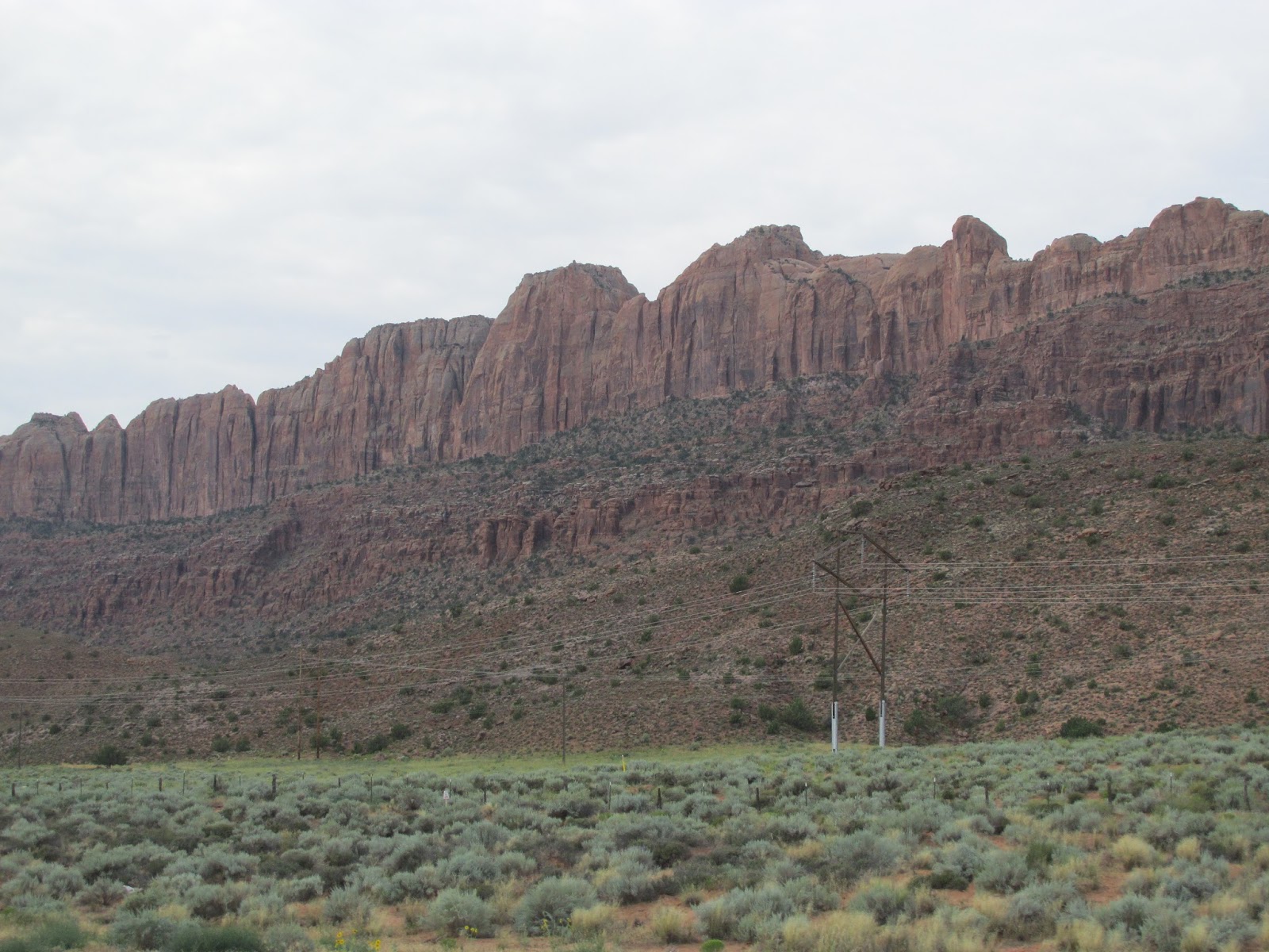
 South of Moab, the scenery is just as amazing! While your are driving south on Route 191, you have the rock
cliffs on the west and the LaSal Mountain Range on the east. This scenery is beautiful just
beautiful!
South of Moab, the scenery is just as amazing! While your are driving south on Route 191, you have the rock
cliffs on the west and the LaSal Mountain Range on the east. This scenery is beautiful just
beautiful!

We also were sharing the road with a couple of bikers. In Utah, helmets must be optional, too bad these riders are not smart enough to wear them all the time!

Wilson Arch is located on Hwy 191. It is a great place to
view an arch because of its conspicuous placing. It sits right off the highway;
you can't miss it during daylight hours. When you drive Hwy 191 between Moab and Monticello, you can’t
miss the Wilson Arch. But did you know, if you look to the west, in the
distance you can see some lesser known arches and rock formations in that area.
Looking Glass Rock is visible from Hwy 191, but the arch hidden on the back
side of the large sandstone formation isn’t.

When we drove the La Sal Mountian loop, we drove through a
portion of the Manti-La Sal National Forest. Then today we drove along another
portion of this National Forest. This forest covers almost 2,000 square miles. The
forest is divided into three districts: the La Sal District at Moab in the La
Sal Range near Moab, in the La Sal District at Monticello in the Abajo
Mountains west of Monticello, and the Manti Division on the Wasatch Plateau
west of Price. The only area we have not visited in this forest, is the Manti
Division on the Wasatch Plateau.

Church Rock this oddly shaped sandstone formation along Hwy
191 was erroneously associated with Marie Ogden's nearby utopian community
"Home of the Truth". One of Utah's interesting pages of history tells
about Church Rock, and how the gumdrop shaped rock earned its name. Seems Marie
Ogden's Home of the Truth, a Utopian community, was responsible. With a small
band of followers, Ogden's group moved onto a tract of barren land along Utah's
Route 211 in 1933. Members, abiding by a strict code of conduct, were expected
to work for the common goals of the settlement. Women tended to the domestic
chores and men worked the arid farm acreage. Not far from their farm, the group
set upon a grand plan to hollow out the entire center of a Church Ruins sandstone
dome, by hand, to build a church. Today, the only evidence of this ambitious
plan is the beginnings of a 16 by 24 foot opening chiseled into the rock. But
as Paul Harvey would say … the rest of the story is … The rectilinear opening
at the base of the formation was not, however, an attempt to hollow out the
rock to make it into a church as local lore would have it, but was in fact
dynamited and cut out of the stone by the property owner during the 1940s to
store salt licks and feed for cattle.

Traveling along the Blue Mountain Ridge, we saw windmills
near the base of them. There are pros and cons to these alternative energy
sources. Traveling in southeast Utah, we have fallen in love with the scenery. Monticello
locals say their views, will never be the same. There are 27 massive wind
turbines, called the Latigo Wind Project, along the ridge just north of
Monticello. Each gleaming white tower is 250 feet tall, with three blades each
350 feet in diameter. When aligned vertically, the tower and blade
configuration will rise almost 450 feet above its base.

We stopped for a rest area behind a closed service station, someone took some time to paint this beautiful mural on the building. And look, it is purple! Nice!

It is amazing that after all these rock formations and mountain
ranges we were traveling across such flat terrain.

We saw our first large body of water that was not a river. Recapture
Recreation Area and Reservoir. It is off the beaten path a bit, but it is a
quiet place to camp, relax and catch warm water fish. It's nestled in some of
the most beautiful country Utah has to offer.

Blanding is the gateway to Utah's Canyon Country. Blanding
offered us a beautiful view of “old town” charm with potted flowers, tree lined
sidewalks and unique clock. With a population of over 3,000, it is the most populated city in San Juan County. It was settled in the late 19th century by Mormon settlers, predominantly from the famed Hole-In-The-Rock expedition. I will blog about that expedition in a later blog.

Blanding is located near both the Navajo and White Mesa Ute Native American reservations, and a significant percentage of Blanding's population has family ties to these nearby cultures. Blanding is a gateway to an abundance of nearby natural and archaeological resources.

After Monticello, Route 191, is now known as America’s Byway
- Trail of the Ancients. An ancient trail to modern-day discovery, this federally
designated, in 2005, National Scenic Byway circles through the ancient Puebloan (Anasazi)
Country of southeastern Utah. An extension of this route continues into Colorado, to Mesa Verde and Canyons of
the Ancients National Monument, which we will travel on later. The Anasazi - the "Ancient Ones" to the later Navajo, guarded their secrets closely. We know they dominated the Colorado Plateau for hundreds of years, yet basic questions about them - who they were, how they lived, what they believed - remain less than fully resolved. This route across the broken, arid terrain of their former civilization is heavily laden with clues like cliff dwellings, rock art, and pottery shards.

Skirting the edge of the UTE Mountain Tribal lands.The Southern Ute reservation consists of timberlands on high mountains with elevations over 9,000 feet in the eastern portion, and flat arid mesas on the west. Seven rivers run through the reservation and water is a valuable resource. Its ownership became a central issue between the Ute people and non-Indians who lived on fee lands on the checker boarded Southern Ute Reservation and for the Ute Mountain people who were surrounded by non-Indians who deprived them of water for their people. The conflicts were ultimately settled by the 1988 Ute Water Rights Settlement Act. The Southern Ute Tribe has approximately 1,400 tribal members, with half the population under the age of 30. The Southern Ute Reservation is situated on a 681,000 acres reservation.


These different landscapes culminated with rock cliffs on what looks like three sides of you!

Heading into Bluff, Utah we learned that the population is about 250.

We passed Bluff Fort. I will tell you more about the Fort in a later blog.

We found the only Mexican Restaurant in town!

We arrived at Cottonwood RV Park, passing by a Sinclair gas station, an automatic laundry (not sure what is automatic about a laundromat,) a closed gas station, a closed parts store, a small cafe and the only steak house in town! This is our home for the next three nights!
No comments:
Post a Comment