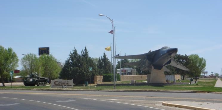
We departed Travelers World RV Park in Clovis NM and the next thing we saw, was Cannon Air Force Base. There are approximately 6,000 military and civilian personnel on this base. The base covers almost 4,000 acres of land. The Melrose Air Force Range training area, which is approximately 25 miles west of the base, is used for air-to-ground, small arms and electronic combat training. It is approximately 70,000 acres, and operations there cover 2,500 square miles of airspace. Cannon AFB is home to Air Force Special Operations Command’s 27th Special Operations Wing. The wing is one of four Air Force active-duty special operations wings within AFSOC.

Cannon Air Force Base can trace its roots back to the late 1920s when Portair Field, a civilian passenger facility, was built on the site. Portair Field was a terminal for early commercial transcontinental journeying. Portair Field was renamed Clovis Municipal Airport in the 1930s. The war years saw the introduction of heavy bomber training to the “Llano Estacado.” It is a Spanish term for Staked Plain, referring to a region that includes portions of eastern New Mexico and northwest Texas. In September 1942, Clovis Municipal Airport became Clovis Army Air Field. Flying operations nearly came to an end with postwar demobilization, aside from the rare refueling of transient aircraft. Clovis Army Air Field had “closed its doors” by May 1947, as the base went on the inactive list. Although it remained in the hands of Air Training Command until late July 1951, when it was obtained by Tactical Air Command. At that time, an Air National Guard unit, the 140th Fighter-Bomber Wing, was activated, mobilized to active duty and stationed there. Cannon Air Force Base was named in honor of the former commander of the Tactical Air Command, Gen. John K. Cannon. In February 1959, the base entered into a relationship with the 27th Fighter Wing that continues to this day, albeit with the new mission of special operations. When the base transitioned from Air Combat Command to Air Force Special Operations Command in October 2007, the 27th Fighter Wing was re-designated the 27th Special Operations Wing.

The last town in New Mexico is Texico. The name is a portmanteau of "Texas" and "New Mexico". The town of Farwell borders Texico on the Texas side of the border. After Farwell, we took 84 East.
We passed by the headquarters for Parmer County Cotton Growers. We never thought that cotton was grown in TX. It always seemed like something that was grown in the South. Who knew?

We came into the Town of Muleshoe. It is home to the Muleshoe National Wildlife Refuge. It is the oldest national wildlife refuge in Texas and was established in 1935. Most of the short-grass prairie habitat has never seen a plow and stands today as it did hundreds of years ago. Important to migratory birds and many resident species of wildlife, the refuge is best known for hosting one of the largest concentrations of lesser sandhill cranes in North America. It is estimated that every year approximately 15 percent of the lesser sandhill crane population depends upon the refuge between the fall and spring. Muleshoe National Wildlife Refuge offers wildlife-dependent recreation, including wildlife watching and photography. The over 6,000-acre refuge is part of the National Wildlife Refuge System, a national network of lands and waters set aside for the benefit of wildlife, habitat and you.

We came to Littlefield Texas and learned that it was the hometown of Waylon Jennings. The late country music singer was born and raised in Littlefield and residents are always proud to brag about it. Jennings passed away in 2002, but his legacy lives on in Littlefield thanks to his younger brother. James Jennings is the owner and operator of Waymore's liquor store, which is located along Waylon Jennings Boulevard. James makes his money selling the liquor, but he honors his brother with a little room in the back of the store. Floor to ceiling and door to door, history is preserved inside the walls in the back room of the store. James has dedicated the room to Waylon by filling it with memorabilia. Album covers, posters, photographs and hundreds of other items that belonged to Waylon a can be found in the back room at Waymore's. The timeless treasures attract Waylon fans from all around the world. There is no charge to tour the museum. The memories displayed on the walls are priceless.

We passed by several Pecan Orchards near Lubbock. Pecans in Texas? I thought that Pecans were a southern thing too. The pecan tree was designated the official state tree of Texas in 1919 (the pecan pie was also adopted as the state pie of Texas). Fossil remains found in Texas show that the native pecan tree was here long before humans came on the scene. Remarkably long lived, the pecan can survive more than a thousand years and grow over 100 feet tall. Besides producing the delicious pecan nut, pecan wood is used in baseball bats, hammer handles, furniture, wall paneling, flooring, carvings, and firewood.

On Route 84, we passed the Stars and Stripes Drive In Theater. It has been showing movies to the Lubbock Region since August of 2003. However, the drive-in story goes all the way back to 1948 when the owners grandfather started the Sky-Vue Drive-In Theater in Lamesa, Texas. He grew up hearing great stories about the people, the events, and the food that made this small west Texas business the pride of the town. While experiencing his first drive-in movie at the Sky-Vue in June of 2002, he felt a calling to share this slice of Americana. In January of 2003 he purchased a Lubbock cotton farm, and on August 21st Stars & Stripes Drive-In Theater started showing double-features and serving Rockin' Eats. The theater offers a retro setting with three outdoor screens for double features, plus an on-site American cafe. The first movie playing, Charlie and I saw already with our son and granddaughter in Phoenix.
After Lubbock, we headed east on US 82. We will be traveling east on US 82 all the way to Georgia! On the Welcome to Ralls Texas sign it has “in God we trust” on the bottom of the sign. It is very nice to see that, in this crazy, crazy world!

We stopped at the Silver Falls Rest Area, which shares a border with Blanco Canyon. Blanco Canyon, which snakes through the county near Crosbyton east on Texas Highway 82, is a historical site whose story reaches back to prehistory. The canyon provided man water, shelter, game, and vegetation throughout time.

To the ancient inhabitants, it was seen as a Garden of Eden, where wanderers could rest. In the nineteenth and early twentieth century, it was a favorite hunting site of Comanche Chief Quanah Parker. Blanco Canyon was also the site of the important running battle between the Comanche and the U.S. 4th Cavalry under Col. MacKenzie.

From the battle MacKenzie learned valuable lessons that led to the final defeat of the proud Comanche. You can access part of the canyon at Silver Falls Rest Area. The rest area contains newly constructed rest facilities, WiFi access, information about canyon history and a Works Progress Administration built stone staircase leading down into the creek bed. There were signs that said "watch for Rattlesnakes" so no walking in the grass or creek bed for me!
As we drove, we learned that not all of TX is flat! And we found some more rocks for Charlie to see!


The sign read Dickens County Springs 1891, it looks like it is by a park? At one time, water covered this area. Sandstone, the prominent rock around this site, is porous, causing exposed strata at canyon rims to form a natural drainage outlet for upland aquifers, making possible the existence of these springs. Situated at the head of a canyon ravine immediately below the Upper Prairie Region of the Rolling Plains, the ancient springs have been a favored human habitat since the earliest human occupation in this region.

Many nomadic tribes have used the site, leaving behind a wealth of archeological evidence. John A. Askins and his family settled near these springs in late 1883, and it became known to pioneers as Askins Springs. A traveling real estate developer called Dr. M. S. Crow arrived here in 1891 and was a driving force in the organization of the town of Dickens about a half-mile west of the Askins land. In 1891 he gave a speech proclaiming his intent to give ten acres around "Crow Springs," as he called them, to the town of Dickens. The new city park became known as Dickens Springs. In 1978 the departments of Anthropology and of Park Management at Texas Tech University made an intensive survey of the land surrounding Dickens Springs. Though many artifacts were lost to souvenir hunters, the university workers uncovered a variety of ancient tools, rarely of local origin.

 We stopped at the Narrows Rest Area and I caught a glimpse of a road runner. Not the cartoon road runner, but the real bird! This most famous bird in the southwest, featured in folklore and cartoons, known by its long tail and expressive crest. The Roadrunner walks and runs on the ground, flying only when necessary. It can run 15 miles per hour, probably with much faster spurts when chasing a fast-running lizard or other prey. Its prowess as a rattlesnake fighter has been much exaggerated, but it does eat a remarkable variety of smaller creatures.
Before you get to the town of Vera, all you see is rows and rows of windmills. I know there is a great deal of controversy over them, but I still like to see them! What was interesting about these, is there were two that were a darker grey than the rest of the windmills. They really stood out! Vera was originally known as White Flat for the local terrain. That is one of the reasons for all the wind turbines. However, the name posed a problem when a post office was applied for around 1890. The town was then renamed after Vera Kellogg, the daughter of early an early settler (Holt Kellogg). Stock-raising and farming were the first businesses and these were joined by cotton production about 1900. During a series of school consolidations, Vera came out on top - but finally lost out in 1960 when students started attending classes in Seymour or Benjamin. From just 100 people reportedly living there in 1960, Vera hit a record high in 1970 with 276 people and then declining.
Before we got into the heart of Seymour Texas, we spotted La Siesta Motel and RV Park. We stopped to see if they had a space for the night. They did, twenty five bucks for water, electric and wi-fi. Not bad! This will be our home for one night!
No comments:
Post a Comment