OK in part one of our Activities around Moab, I left
off at the Wetland Preserve on Kane Creek Blvd, picking up from there …. As we
were driving on Kane Creek Blvd hugging the Colorado River on our right, I was
snapping pictures, the scenery is beautiful, the Colorado River and the Red
Rocks stretch as far as you can see.
 About three miles down the road, on the left there
was the Moonflower Canyon, it offers some petroglyphs and hiking trails. It's absolutely gorgeous. This is a popular
rock art panel that is easy to access from a passenger car. This petroglyph
dates from the Archaic to Formative Periods. The highlight of visiting this
site is the log ladder. The ladder is located on the left side of the rock art
panel hidden in a chimney. The ladder is a reconstruction of those used by
Native Americans. The ladder was constructed by jamming logs into the cliff
side. There is a small, eight sites, BLM walk-in campground.
About three miles down the road, on the left there
was the Moonflower Canyon, it offers some petroglyphs and hiking trails. It's absolutely gorgeous. This is a popular
rock art panel that is easy to access from a passenger car. This petroglyph
dates from the Archaic to Formative Periods. The highlight of visiting this
site is the log ladder. The ladder is located on the left side of the rock art
panel hidden in a chimney. The ladder is a reconstruction of those used by
Native Americans. The ladder was constructed by jamming logs into the cliff
side. There is a small, eight sites, BLM walk-in campground.
The sandstone cliffs with petroglyphs represent an outdoor
gallery during earlier times. Native Americans painted and chipped their
religious visions, important events and their history. The Antiquities Act of 1906 and Archaeological Resources
Protection Act provides serious penalties to vandals. It is sad, these
petroglyphs are the most susceptible to graffiti. Why do people have the urge
to carve their names into these rocks that hold our history?
Further down the road are home that look
like they are built into the rock. Plus several open caves, all were posted
with “no trespassing signs.”
 But, it makes you very curious … what is in these
caves?
But, it makes you very curious … what is in these
caves?
 We found one mobile home on the top of the rocks,
with a gas line running along the rock to the mobile home. From across the
river, we got a few additional pictures … strange place to live? Or is it a
business? We could not find a road up there, but they must have access someway,
besides the metal steps?!
We found one mobile home on the top of the rocks,
with a gas line running along the rock to the mobile home. From across the
river, we got a few additional pictures … strange place to live? Or is it a
business? We could not find a road up there, but they must have access someway,
besides the metal steps?!
A bit further down the road, there was two Pueblo
style stone homes along the front of the rock.
They were not posted and I ventured a
little way into them …
I was too chicken to go too far in … but they were
pretty cool!
At the Kane Creek campground at the end of the paved
road offered full hook-up sites. It had an unfinished grey adobe style home at
the top of the hill.
PIC #36 Turning around, we headed back toward town, where we
passed a very large and impressive home on Kane Creek Blvd. It is probably the
only home worth the Boulevard designation!
On Monday, August 1st, we took a drive on River Road
Scenic Byway, Route 128. This road runs from Route 191 to Interstate 70 in
Cisco. Charlie told us this was a road they used to use to go between Arizona
and Colorado, when they wanted to cut part of I-70 off.
This road starts at 191 and the Colorado River
Bridge. It follows along the banks of the Colorado River with rock formations
and cliffs on both sides, providing breathtaking views. About three miles down
the road, we passed Negro Bill Canyon. The canyon offers an impressive Navajo
Sandstone gorge containing many hidden secrets including the massive Morning
Glory Natural Bridge, the sixth longest natural rock span in the US. It is a
four mile hike that follows a perennial stream.
PIC #64 About thirteen miles down the road, the gorge widens
as we pass the Castle and Professor Valleys, which have been the shooting
locations for many western movies and some commercials.
About twenty one miles down the road, you can see
Fisher Towers. Fisher Towers are composed of Moenkopi and Cutler Sandstones
that have eroded into many fantastical shapes.
After leaving the valley, the road widens farther
up the river gorge where we could see rafters getting in the river.
We arrived at the Historic Dewey Bridge. It was the
longest wooden suspension bridge in the Utah. Too bad, the Dewey Bridge was
destroyed in April, 2008, by a 7-year old boy, from Grand Junction Colorado. He
was camping with his parents about a quarter-mile away, wandered down to the
river, and started a brush fire with matches. The suspension bridge was the
second-longest west of the Mississippi; only the Golden Gate was longer. The Bridge’s value was estimated at $530,000.
No insurance would cover the cost to rebuild, so the metal components of the
bridge remain today. After the bridge over the Colorado River, the road proceeds
across open desert toward the ghost town of Cisco.
We turned around before we reached I-70 and headed
west on 128. Our destination was the Red Cliffs Lodge for lunch, a tour of the
film museum and wine tasting at Castle Creek Winery.
We thought that we would
enjoy our lunch in the beautiful dining room, but they were having an open air
BBQ. So, we walked around the Lodge and made our way to the pavilion. The lunch
spread was amazing and very cost effective, $10.50 per person for all you can
eat! They had burgers, hot dogs and grilled chicken, all the fixins, four
different salads, fresh fruit and huge cookies! We ate too much, but it all was
delicious!
Good thing we had to walk up to the winery, we
could walk off a bit of our lunch! For the wine tasting, we were able to select
3 different varieties. I selected what I thought would be three that were kind
of sweet and fruity … the only one was … but then again, I am not a real wine connoisseur!
The Castle Creek Winery touts itself as Utah's first and largest winery. It was
the 2016 winner in "The Best of Utah" competition. Some of the group
purchased wine and other items they had for sale there. We left the winery and
walked back to the Lodge to view the museum.
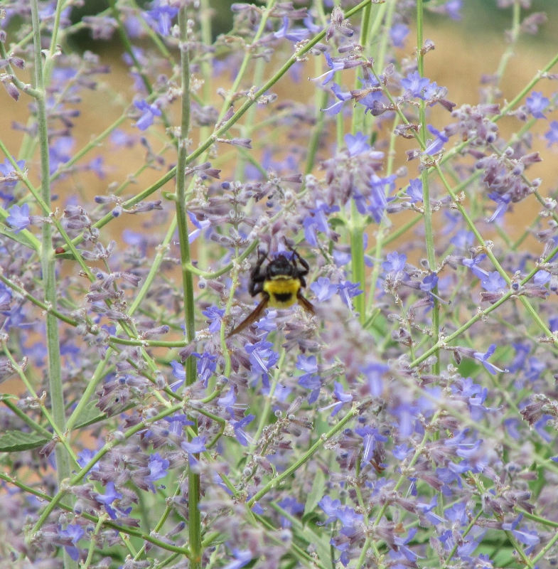
On the way, we passed their gardens and beautiful flowers …
I am a sucker for both!
Lavender being pollinated by a bee!
 We also had to look at some vintage automobile that were on display between the lodge and the winery!
 This was our second tour of
the Movie Museum, it does not disappoint! There have been many movies filmed in
the Moab area and on the Colorado River that runs through Moab.
This was our second tour of
the Movie Museum, it does not disappoint! There have been many movies filmed in
the Moab area and on the Colorado River that runs through Moab.
The Red Cliff
Lodge has a museum dedicated to these movies and the boost it gave the local
economy. Some of them surprised us that they were filmed here! Here are some of
the movie names: Mission Impossible II, The Adventures of Joe Dirt, Galaxy
Quest, Chill Factor, Lost Treasure of Dos Santos, Con-Air,
Breakdown, Riders of
Purple Sage, Larger Than Life, The Great American West, Lightening Jack, City
Slickers II, Geronimo: An American Legend, Slaughter of the Innocents, Knights,
Thelma and Louise, Indiana Jones and the Last Crusade, Sundown, Nightmare at
Noon, The Survivalist, MacGyver (TV Pilot), Choke Canyon, Rio Conchos, The
Comancheros, Warlock, Rio Grande and Wagon Master … just to name a few!
After our museum tour, we decided to drive the La
Sal Mountain Loop Scenic Backway.

This drive offered us expansive views of
spectacular scenery ranging from the rock mountain tops, to green forests and unbelievable
views of the red rock landscapes below. We started in Castle Valley and ended
up back on Route 191.
Near the summit of our drive, we ran into a group
of horses standing in the middle of the road. They looked at us, but never
moved an inch as we went off the road around them.
Just a bit down the road, we found one more lone
horse.
A few hairpin turns later and a few feet lower in
elevation, we found a cow along the side of the road and a second cow was
laying along the road in the shade.

On Monday night, before we went to the grocery store. We toured
Potash Road (Route 279) it runs along the north side of the Colorado River
opposite Kane Creek Blvd.
Where we were able to see the Potash Road Rock Art
Sites. There was two areas, both had the "Indian Writing"
interpretive road sign and pull out adjacent to the river.
Looking 20 feet up
the rock wall on the cliff side of the road we could see petroglyphs from the
Formative Period.
There was a line of people that looked like "paper
dolls," as well as a wide variety of other animal and abstract images. The
round holes carved into the sandstone underneath the left side of the
petroglyph panel once held the roof poles of a structure which was excavated by
archaeologists prior to road construction.

We found two people that were rock climbing these shear cliffs. It is not a real clear picture, but they were close to the road and pretty high up!

We found a family of turkeys in a walk-in BLM camping area. I saw them on the way down the road, but was not sure ... I thought they might be buzzards. On the way back we pulled into the parking area and this is what we saw.
A parent and a young turkey even jumped on a split rail fence for us!
Tomorrow we depart Moab for Bluff Utah, one last sunrise to enjoy!

 About three miles down the road, on the left there
was the Moonflower Canyon, it offers some petroglyphs and hiking trails. It's absolutely gorgeous. This is a popular
rock art panel that is easy to access from a passenger car. This petroglyph
dates from the Archaic to Formative Periods. The highlight of visiting this
site is the log ladder. The ladder is located on the left side of the rock art
panel hidden in a chimney. The ladder is a reconstruction of those used by
Native Americans. The ladder was constructed by jamming logs into the cliff
side. There is a small, eight sites, BLM walk-in campground.
About three miles down the road, on the left there
was the Moonflower Canyon, it offers some petroglyphs and hiking trails. It's absolutely gorgeous. This is a popular
rock art panel that is easy to access from a passenger car. This petroglyph
dates from the Archaic to Formative Periods. The highlight of visiting this
site is the log ladder. The ladder is located on the left side of the rock art
panel hidden in a chimney. The ladder is a reconstruction of those used by
Native Americans. The ladder was constructed by jamming logs into the cliff
side. There is a small, eight sites, BLM walk-in campground. 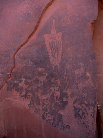

 But, it makes you very curious … what is in these
caves?
But, it makes you very curious … what is in these
caves?  We found one mobile home on the top of the rocks,
with a gas line running along the rock to the mobile home. From across the
river, we got a few additional pictures … strange place to live? Or is it a
business? We could not find a road up there, but they must have access someway,
besides the metal steps?!
We found one mobile home on the top of the rocks,
with a gas line running along the rock to the mobile home. From across the
river, we got a few additional pictures … strange place to live? Or is it a
business? We could not find a road up there, but they must have access someway,
besides the metal steps?!


 We also had to look at some vintage automobile that were on display between the lodge and the winery!
 This was our second tour of
the Movie Museum, it does not disappoint! There have been many movies filmed in
the Moab area and on the Colorado River that runs through Moab.
This was our second tour of
the Movie Museum, it does not disappoint! There have been many movies filmed in
the Moab area and on the Colorado River that runs through Moab. 


No comments:
Post a Comment