

Every year the main street of Custer SD is adorned with
buffalo statues which various artists paint. They remain alone the street for
the summer and then are auctioned off in the fall. These are some of the
statues from this year.

Did I mention that we saw two of Pattye Starrett's favorite things ... a purple house that is home to an ice cream parlor! Bonus!

The 1881 Courthouse Museum is an American historical museum
located in Custer, South Dakota. The museum is housed in the original Custer
County Courthouse which served as a center for government in Custer County and
the Dakota Territory from 1881 to 1973. In November 1972, the 3-story red-brick
courthouse was designated a historic site by the U.S Department of Interior.
Following completion of a new courthouse located across the street, the
original building was given to the Custer County Historical Society in 1973.
The 1881 Custer County Courthouse museum was opened on September 6, 1976, by
the Custer Country Historical Society. The museum houses exhibits about the
Lakota Native American culture, the 1874 expedition of George Custer, and the
lives of Victorian-era settlers in the Black Hills and Dakota Territory.

The Four Mile Ghost Town, located exactly four miles west of
Custer. It is one of the Black Hills last ghost towns. During the 1800s if a
township was not given a name they were assigned numbers to help aid the
stagecoaches, and that’s how the name Four Mile Town came to be.
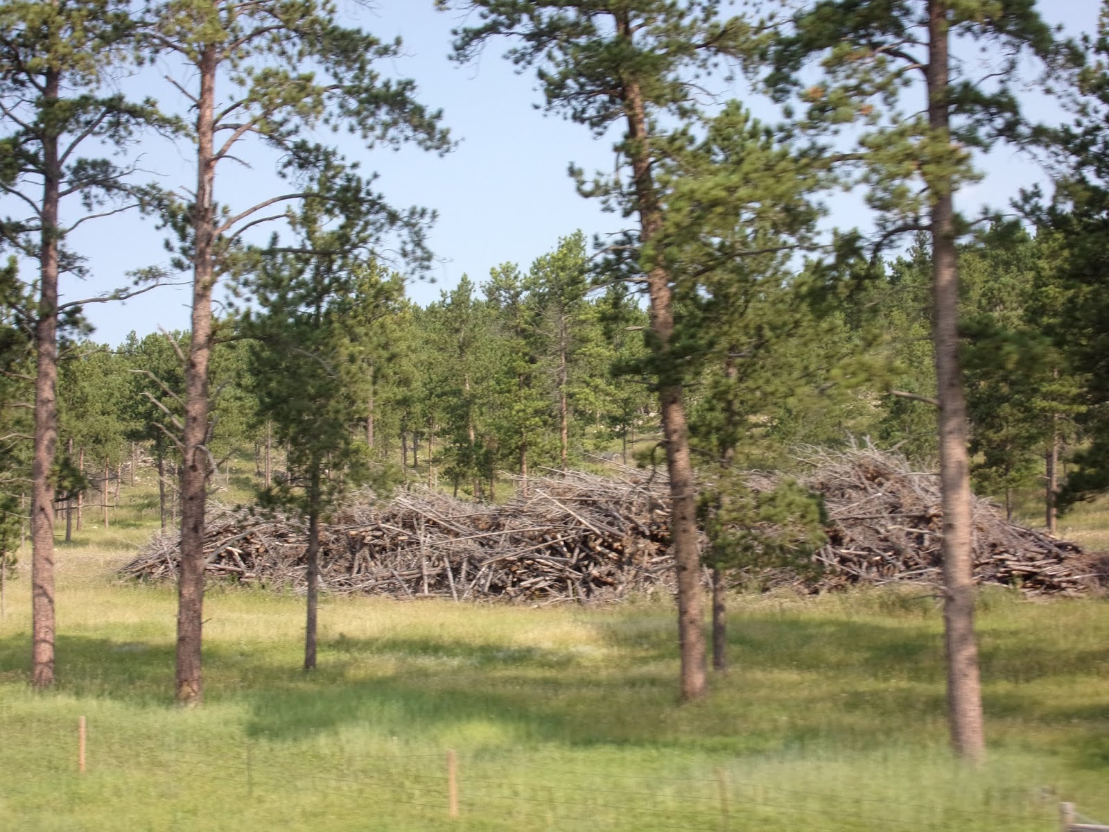
As we drove, we could see piles of dead brush. We learned
that is there is enough snow, this winter, those piles will be burned. The
thinning is done to stop the Mountain Pine Beetle from jumping from tree to
tree and to give more room to other trees to grow.

If you follow my blogs, you know how much I love unique "crossing" signs ... well you can add another one to the list ... I think this tops the peafowl crossing sign!

We passed acres upon acres that were left bare from a fire,
just charred tree trunks remain. The underbrush has started to grow back, but
there is no trees yet! It is a very slow process to grow the forest back. August
of 2000 an enormous wildfire started just west of Jewel Cave. Named the Jasper
Fire, it burned a total of 83,508 acres in the southern Black Hills and
approximately 90% of the land area of Jewel Cave National Monument. Due to the
hot, dry conditions and an abundance of fuel on the forest floor, the fire
spread quickly and with severe intensity. In just the first day, the fire
consumed an average of about seven football fields of forest per minute.

Saw a sign that indicated that we are leaving the Black Hills
National Forest. We have seen these signs before, as we weaved in and out of
the forest, but I believe we really are leaving this time.

We left South Dakota and entered Wyoming. It is the 10th
largest by area, the least populous and the second least densely populated
state in the country. Wyoming is bordered by Montana, South Dakota, Nebraska, Colorado,
Utah, and Idaho.

In Wyoming we saw oil pumpers, also called donkeys. Wyoming ranks
eighth nationally in crude oil production. Last year they produced 75.6 million
barrels of crude oil. The Mike Murphy #1 well was the first oil well drilled in
Wyoming. It was drilled in 1884 next to a natural oil seep and was the
discovery well for the Dallas field, which is still an active oil field today. Salt
Creek field is the most prolific oil field in Wyoming. In 2017, it produced
more than 4.1 million barrels. Since its 1889 discovery, Salt Creek field has
produced more than 715 million barrels of oil, with an estimated 1.8 billion
barrels still remaining in reserve.

The first refinery in Wyoming was built in Casper and began
processing crude oil in 1895. It had an initial capacity of 50–100 barrels of
oil per day. In comparison, Casper’s existing Little America refinery has a
total operable capacity of 25,500 barrels per stream day. Horizontal wells now
account for 87 percent of all new oil and gas wells drilled in the United
States. In 2017, 88 percent of the approved oil and gas permits in Wyoming were
for horizontal wells.

In Newcastle Wyoming, we turned onto US 85 N. Our first rest
stop was at the Salt Creek Overlook. Below us are Salt and Beaver creeks where the bur oak grows. Above the valley floor, Ponderosa pine and aspen groves cling to the limestone cliffs, clay soil and red sandstone. History, geology and wildlife are alive and well in the Salt Creek Valley. The Sioux believed the Great Spirit lived in these hills. Pioneers came here to mine for coal and oil. Small towns, like nearby Cambria, sprang up as fast as they were deserted. Tales of gunfights, stage robberies and gambling are kept alive by those who never left.

White-tailed deer roam through the pines and aspens. Wild turkeys scratch through leaves and needles along the creek bottoms, in search of acorns and seeds. Brought here from New Mexico in 1948, turkeys are now the most widespread game bird in northeastern Wyoming. These shy, elusive birds don’t let humans get too close. At night, they roost in treetops and return to the ground at daybreak to forage. Watch closely and you could see one of these magnificent birds!


It is amazing how Rod can fit us all in,
with a bunch of motorcycles there already!

In the early 1920’s, the Cambria Fuel Company recognized the
need to have an appropriate facility to host company events, as well as be
suitable and accessible to the community to hold meetings and gatherings in a
park-like setting. The inside of the
building would be spacious and accommodating for every need. The outside
amenities would be made to hold company and community picnics and other
events. Hence, the original name was
given and known by as the “Cambria Casino Park”.

Vision became reality when construction started in 1923 for
the new facility, and five years later it was completed in 1928, at a cost of
$250,000. The facility was built in a
European Tudor style, replete with custom stone walls supplied from local
quarries. Shortly after the completion
of the building, two major events occurred that changed the course of its
future history. First, was the closing
of the Cambria Fuel Company and the coal mine, and in 1929, was the crash of
the stock market. The Great Depression
had begun… The Cambria Fuel Company’s property was sold off in pieces. The property originally known as the Cambria
Casino Park was sold and eventually through the years, the property was
acquired by the Napolitano family and has been in the family ever since.

They get that white stuff in the winters up here. I am told
winter can last 8 months … so, they keep their snow fences up all year. They
look much sturdier than the ones that go up and come down every year in NY!

Four Corners is a small unincorporated town in northeastern
Wyoming, at the intersection of US Route 85 and Wyoming Hwy 585. Originally a
stage station on the famous stagecoach road connecting Cheyenne and the Union
Pacific Railroad with the gold fields of Deadwood. Today it looks pretty
abandoned, but maybe a small store and post office serving nearby ranches, vacation
homes, and tourist camps.

Our first glimpse of Devils Tower was from 20 miles away as
the crow flies, it is truly an impressive structure.

As we arrived at Devils Tower KOA, we were greeted by the "dawn patrol."


The dawn patrol are fellow caravanners that volunteer to go ahead of the group and help get the gaggle of RVs off the road and into sites.

We were assigned a spot in
the first row, making the view of Devils Tower spectacular and uninterrupted!
It was hot, hot when we arrived, so we got set up and took shelter under the
large oak tree next to our site. We enjoyed the view of the tower and the
breezes that blew. The line to get into Devils Tower was long all day, we are
told that it gets better around 5 pm.

We decide to head up to Devils Tower around five o’clock.
Located in the northeast corner of Wyoming, it is the country's first national
monument. It was established in 1906 by President Theodore Roosevelt. It is a towering
butte that is made up of igneous rocks. Devils Tower is a jaw-dropping
geological feature that rises almost 900 feet above Wyoming's rolling prairies.

While Devils Tower National Monument garnered significant
attention as the backdrop in Close Encounters of the Third Kind, the tower is
sacred to many Northern Plains Indian tribes, as well as the Kiowa Tribe, who
made their homes in the Black Hills region. With oral storytelling and a
history that dates back thousands of years, today American Indian tribes
continue to hold sacred ceremonies at the tower. Like many significant sites in
the area, its name has a story. Native Americans have several names for the
butte, including Bear’s House and the Great Gray Horn. The name Devils Tower
came from a mistaken translation of a conversation with a Native speaker during
an 1875 military expedition.

While the Tower is a favorite climbing spot, attracting
hundreds of climbers each summer, however several Plains Indian tribes consider
climbing a desecration of a sacred place. Therefore, most climbers honor a
voluntary climbing ban during the month of June each year. It is during that
time when Native ceremonies are conducted around the breathtaking landmark. Personal
and group ceremonies, like Sweat lodges, sun dances, and others are still practiced
at the monument today. The most common ritual that takes place at the Tower are
prayer offerings. Colorful cloths or bundles are placed near the Tower, commonly
seen along the park's trails, and represent a personal connection to the site.
They are similar to ceremonial objects from other religions, and may represent
a person making an offering, a request, or simply in remembrance of a person or
place.

Back to the climbers, we saw them on three sides of the Tower. The first recorded climb of Devils
Tower occurred over ten years before its establishment as a national monument.
Willard Ripley and William Rogers were two ranchers living near the Tower in
the 1890s. Working together, the two managed to construct a simple stake ladder
which they used to climb to the Tower's summit. As years went on an untold
number of people used it to scale the Tower columns. But by the 1920s the
ladder was in a state of serious disrepair. The bottom section has since been
removed, with the top 200 feet restored by the park service in 1972. Visitors
today can still see the old stake ladder - it is visible with the naked eye,
but more easily spotted with binoculars or a good camera zoom.

The ladder marks the beginning of a long history of climbing
at Devils Tower. Although it was used by others after its construction, only a
handful of stories survive. In 1937, a group of rock climbers sought to make
history by scaling the sides without the use of a ladder. They would start a
new tradition of climbing that still exists to this day.

Prior to 1937, rock climbing was evolving as a sport in
several places around Europe. Fritz Wiessner was a German-American climber and
member of the American Alpine Club (based in New York). Climbing with Lawrence
Coveney and William House, Wiessner led the trio in the first free climb of
Devils Tower. Wiessner helped set the standard of rock climbing at the Tower,
and his name is still attached to the route he and his cohorts pioneered in 1937.

The following year, Jack Durrance began the second
expedition up the Tower columns. He studied the route Wiessner used the year
before, and determined there could be a slightly easier option. What became
known as the "Durrance Route" is today the most popular climbing
route on the Tower. Considered by many to be the least difficult route, it
still provides a challenge to experienced climbers scaling the Tower for their
first time. Within a few years, Durrance would return to the Tower to climb it
again. This next expedition would not be for recreation, however: Jack Durrance
was leading a rescue mission.

Throughout 1941, the eyes of the nation were fixed on the
next "Great War." Europe and Asia were in turmoil, and many knew it
was only a matter of time before the United States joined the fray. However the
attention of the American people, and indeed those around the world, would be
diverted for a short time in October 1941. The story of George Hopkins
captivated people across the globe. A man had gotten himself stuck on the top
of Devils Tower. How he got up there, why he could not get down, and what was
being done to rescue him were conversation topics around many dinner tables.
 The parachutist drew a lot of attention to a little national monument in
northeast Wyoming. In the end, Jack Durrance led a part of eight climbers to
the summit to bring Hopkins down after being stranded for six days. We met a group of three climbers that had scaled the Tower, it only took them 11 hours!
The parachutist drew a lot of attention to a little national monument in
northeast Wyoming. In the end, Jack Durrance led a part of eight climbers to
the summit to bring Hopkins down after being stranded for six days. We met a group of three climbers that had scaled the Tower, it only took them 11 hours!
No matter what your reason for your visit or what is most
inspiring to you, there is something for everyone to enjoy. Nancy and I enjoyed
being as close to it as legally possible, without getting a permit to climb it!
We took the short 1.3 mile loop around the base of it.

This allowed us to
capture pictures from all sides and also to see our RV at the Devils Tower KOA. Our rig is in the first row, right next to the tree in the center of the picture.

We told our husbands we were only going up for a closer look and we started
walking and we were not sure how far around we were … so, we kept pushing
forward, thinking it might be shorter than turning around. Oh, were we wrong …
39 minutes later we finished the 1.3 mile loop! But, we got some awesome
pictures!

On our way out of the park, we stopped at Prairie Dog town,
they are just too cute! The prairie dog town at Devils Tower is found in the
floodplain along the main park road, just past the entrance. It is distinctive
for the dirt mounds which the animals construct, and the low vegetation that is
clipped for improved colony safety.

Prairie dogs build up large stores of body fat to carry them
through the fall and winter months. Unlike most other members of their family,
black-tailed prairie dogs do not hibernate. They may remain underground for
several days during periods of harsh weather, but a return to milder winter
conditions will find their towns bustling with activity.

Plump prairie dogs are an important component of the diet of
many animals. Badgers, coyotes, foxes, bobcats, golden eagles and various hawks
all take their toll; rattlesnakes and bull snakes occasionally prey on the
young. Prairie dogs rely on their excellent hearing and vision to avoid these
predators. From their vantage point atop the burrow mound, they can listen and
scan the sky and prairie for danger. Upon spotting an enemy and announcing its
presence to the rest of the town, the prairie dog dives into its burrow, emerging
to give an "all clear" call when the danger has passed.

Prairie dogs warn of territorial trespassers from adjacent coteries or approaching danger by emitting a series of "barks," which sound more like high-pitched squeaks. Specific threats are associated with distinctive vocalization patterns that serve to alert all residents of a town to the common threat. Prairie dogs spend about half of their lives above ground. We could hear them making all kinds of sounds … not sure if they are announcing our arrival or warning others we are dangerous! When we left, I thought I could hear them giving the “all
clear” sign.

An excellent view, as we left the park!

Another awesome day with Yankee RV Caravan Northwest Expedition.
No comments:
Post a Comment