Day 55 of 117 on our “Go West, Young Man” Two Lane Adventure – Monday 8/20/18
Departed Anderson Camp on I-84 W for just 1 exit. Then we throttled down and will cruise along several scenic byways lined with gushing waterfalls and towering rock formations. We will be meandering roads into deep canyons and teetering on the edge of rivers.
It was a dreary morning, but the sun was trying to peek through the clouds and haze.
We are traveling on mostly flat, barren scenery with volcanic outcroppings here and there. There are many stories to tell in this remote and sparsely populated region of Idaho. The Sheepeater Indians, ancestors of the Shoshone lived along the rivers here, hunting and fishing the forest’s bounty. Rock shelters display pictographs and contain remnants of mussel shells and other items these Native Americans used.
All of the traveling we are doing today is on US Route 93, a 2 lane road for all the way. This is our kind of traveling!
We came into Shoshone, Idaho (with a silent “e”) and were greeted by a welcoming mural.
At one time Shoshone was the only railroad depot in Idaho, even though it’s been a town of just 1,100 to 1,400 people for the last century. The railroad tracks here are still active, and Union Pacific and Amtrak trains still pass through.
It is still flat and the tumbleweed is starting to blow.
We pasted an interesting barn and silo. Once I got looking at the picture, it looks more like it was a dutch style windmill. It’s one of those roadside oddities, that makes you go hhmmmm?!
Richfield, with a population of 467, was established in 1909. It is located along Highway 93 between Shoshone and Carey. Richfield borders the Craters of the Moon National Monument, with close proximity to Shoshone Ice Caves, Mammoth Cave and the Wood River Valley. Since 1954, Richfield has been home to Outlaw Day. It has been held continually every June, since then. There are some events unique only to Richfield. Outlaw Day is an event that was started by some local cowboys wanting to raise money for a community pool which soon turned into an annual event for friends and families to get together every year to kick up their heels and reminisce about past years fun! Activities include Community Breakfast, Parade, Greased Pic Race, Rodeo Events, Mud Race, Pole Bending, 3 Man Cow Race and a Street Dance.
We are traveling on the Peaks to Craters Scenic Byway, without a doubt this byway has the most diverse stretch of road in Idaho. The byway features world-class fly fishing on beautiful Silver Creek and a unique rock formation known as the “Queens Crown.” Idaho’s first national monument, Craters of the Moon National Monument and Preserve, has thousands of acres of lava fields and distinctive rock formations.

Shortly before the entrance to Craters of the Moon, we past a historical marker for Goodale’s Cutoff. Who is Goodale and what did he cut off? A little background first … The Oregon Trail followed the course of the Snake River. In 1852, John Jeffrey began promoting a spur trail which traced traditional Shoshoni migration routes. He wanted to generate business for his ferry at the mouth of the Blackfoot River. Although the cutoff received some use from 1852 to 1854, it was not until a decade later that a large percentage of Oregon Trail traffic chose the route. In 1862 an emigrant party asked guide Tim Goodale to lead them west from Fort Hall on the cutoff pioneered by Jeffrey. They hoped the alternate trail would enable them to reach the Salmon River gold fields more directly. Goodale succeeded in leading a group of 1,095 people, 338 wagons, and 2,900 head of stock safely from Fort Hall to Boise. It took this enormous wagon train -- the largest to travel any section of the Oregon Trail -- over 3 hours to get into or out of camp. The growing Indian hostility along the trail resulted in increased demand for a safe alternative. In 1863, seven out of every ten wagons en route from Fort Hall to Boise took Goodale's Cutoff instead of the main Oregon Trail. Goodale's Cutoff is visible at many points along Highway, 20/26/93 between Craters of the Moon National Monument and Carey.

The Sawtooth National Forest is on our left and it is flat, flat, flat on the right. The Sawtooth National Recreation area has over 700 mile of trails, 40 peaks rising over 10,000 feet and 300 plus high mountain alpine lakes. Sounds like a haven for the outdoorsmen!
We knew we were getting close to the Craters of the Moon, as the surrounding desert landscape changed around us into black hardened lava rock.
We are probably the only RV caravan that takes the coaches and their towed vehicles on the 7-mile loop road at Craters of the Moon. Craters of the Moon is a vast ocean of lava flows with scattered islands of cinder cones and sagebrush.
There are just a few places in the world where you can explore underground lava tubes and see where molten lava once flowed for miles on end and Craters of the Moon is one of them.
Many of the 750,000 acres of Craters of the Moon National Monument and Preserve are undeveloped, rugged dirt and gravel roads and warrant a high-clearance, 4-wheel drive vehicle with good tires. We will stick to the loop road!
While seemingly barren, the park’s lava fields and arid sagebrush areas sustain a surprising diversity of plant life. The dwarf buckwheat plants grow with such regular spacing that you might think someone planted them. But the regular spacing occurs naturally because the plants compete for water through their extensive root systems.
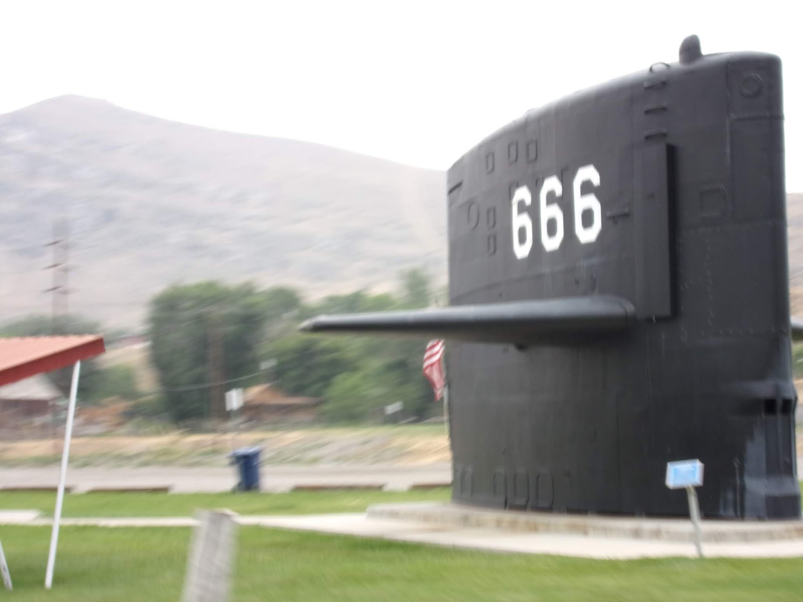
In Arco, the “First City in the World to be Lit by Atomic Energy” you can see a submarine in the desert. Passing through this rural Idaho town of mountains and sagebrush you may ask … What on earth is a submarine sail doing in the middle of the desert? The explanation came when the tall sail, or conning tower, of USS Hawkbill (SSN 666) was officially dedicated to Arco during its "Atomic Days." It was no small task establishing Hawkbill's sail as the only known "Submarine in the Desert." But because of Arco's history in nuclear power development, town enthusiasts latched onto the idea, and when Hawkbill was decommissioned in 2001, the Naval Historical Society donated it to them.

Once the sail was donated, the next step was moving Hawkbill some 1,000 miles from the sea to the high desert. The move was laborious, but made easier when a group of truck drivers agreed to transport the sail in three parts for just the cost of gasoline. Arco, with a population of 1,023, was the site where nuclear propulsion for submarines began. During the Cold War, all of southeast Idaho was a hotbed of nuclear testing and advancements - but because their studies were classified, no one knew about it. Over the last several decades, some 40,000 Sailors trained in nuclear operations at three prototype nuclear power plants in the Arco region. The project hit a glitch when state troopers spotted the massive tonnage moving down the highway on three separate trucks and deemed it too dangerous to continue.

Hawkbill had the unfortunate chronological numbering of 666, earning it the nickname of "Devil Boat." But the ominous biblical numeral never affected its many missions. The submarine deployed 10 times to the Pacific and six times to the Arctic Ocean, where it joined the National Science Foundation in several crucial studies at the North Pole. Now entrusted with Hawkbill, Arco town leaders plan to make it the cornerstone to their future museum, which will highlight nuclear advancements during and after the Cold War.
On the mountain range outside of Arco there is an impressive display of numbers. Every year, the graduating high school class climbs this mountain to paint gigantic numbers of their graduation year on the side of the mountain. As far as we could tell, a tradition that dates back all the way to the 1920’s!
The Lost River Mountain Range was on our right for miles. There are 8 named peaks along this range, with the Leatherman Peak is more easily recognizable summits in the range as it towers above the adjacent Leatherman Pass by over 1600 feet. The peak was officially named in 1917 after Henry Leatherman, who hauled freight in the area during the late 1800’s. But the highest at 12,228 feet is the Borah Peak. Known locally as Mount Borah rather than Borah Peak, this mountain boasts nearly 6000 feet of prominence, making it one of the rare prized ultra-prominence peaks. The standard route, aptly named Chickenout Ridge, should have you rethinking the climb, unless you are well-seasoned!
Nestled beneath the White Knob Mountains and towering Mackay Peak, sits the Mackay Reservoir. In the high desert of the Big Lost River Valley, Mackay Reservoir supports populations of stocked rainbow trout and self-sustaining kokanee. High catch rates of kokanee are the norm in many years. Summer fishing is popular from a boat and from shore. Winter anglers can discover great ice fishing.
The middle fork of the Salmon River is 104-miles of free-flowing whitewater, where every bend reveals a new dramatic vista and a challenge to boaters’ skills. The Middle Fork is one of the original eight rivers in the nation designated as Wild and Scenic in 1968. Today it is an internationally recognized whitewater, wilderness float trip. It boasts many class III and IV rapids.
We passed through Grand View Canyon, at least that is what the sign called it. The canyon has for years been called Box Canyon by the longtime residents of the area.
The highway through the canyon is approximately 2 miles of twists and turns with rock croppings close to the road. Scenic equals scary, one caravaneer might say.
We transitioned onto the Salmon River Scenic Highway. The route follows the Salmon River through the Salmon-Challis National Forest. Even though the Main Salmon Rover is within the Frank Church-River of No Return Wilderness. There is a 79-mile “wild” section that allows powerboats, unlike other Wilderness Rivers. This portion of the river is not as technically difficult as the Middle Fork of the Salmon River.
In Challis we saw some Helitack helicopters. Helitack crews are teams of firefighters who are transported by helicopter to wildfires. Helicopters provide rapid transport, enabling helitack crews to quickly respond and assess a wildfire situation. Helitack crews may land near a wildfire or, if equipped and trained, rappel from a hovering helicopter. Once on the ground, crews build firelines using hand tools, chainsaws, and other firefighting tools. They often remain overnight in remote locations.
Thanks to the keen eye of Rosann, we were able to get a picture of what we thought was an elk herd by creek. But looking at the blurry picture now, I am not so sure …. Are they Big Horns? Hmmmmm???
In 1948, after more than a decade on the road and riding the rails, this interesting character got an idea. Working along the banks of Idaho’s Salmon River, fishing and doing some small-scale mining, he figured it was time to settle down. At the age of 32, the restless hermit, Richard Zimmerman, figured the best place to settle was right there in Salmon, Idaho—inside the hill, in a cave dug with his own hands. The people of Salmon soon coined a new name for Zimmerman, who became “Dugout Dick.” The construction of the original cave took several months, and once it was done, Dugout realized he needed a way to make some money. Although the original promise of the land had been its seclusion, Dugout hammered out 14 more caves over the next few years to draw people in.

Dugout was never actually deeded the land, and although essentially a squatter, local authorities and the Bureau of Land Management (BLM) understood his place in the history of Idaho wanderers and settlers. They granted him lifetime rights, with the understanding that the land would be reclaimed by the BLM after he passed away. He squeezed as much time as he could out of the deal, living off the land until the age of 94. After Dugout died, the BLM came in, and (to the dismay of locals and media alike) destroyed the caves citing health and safety concerns. Yet today, located on the hillside, along the Salmon River off US Hwy 93, one can see a glimpse of the former cave village. And by traversing the old wooden bridge and following a dirt road a memorial and the old cabin.

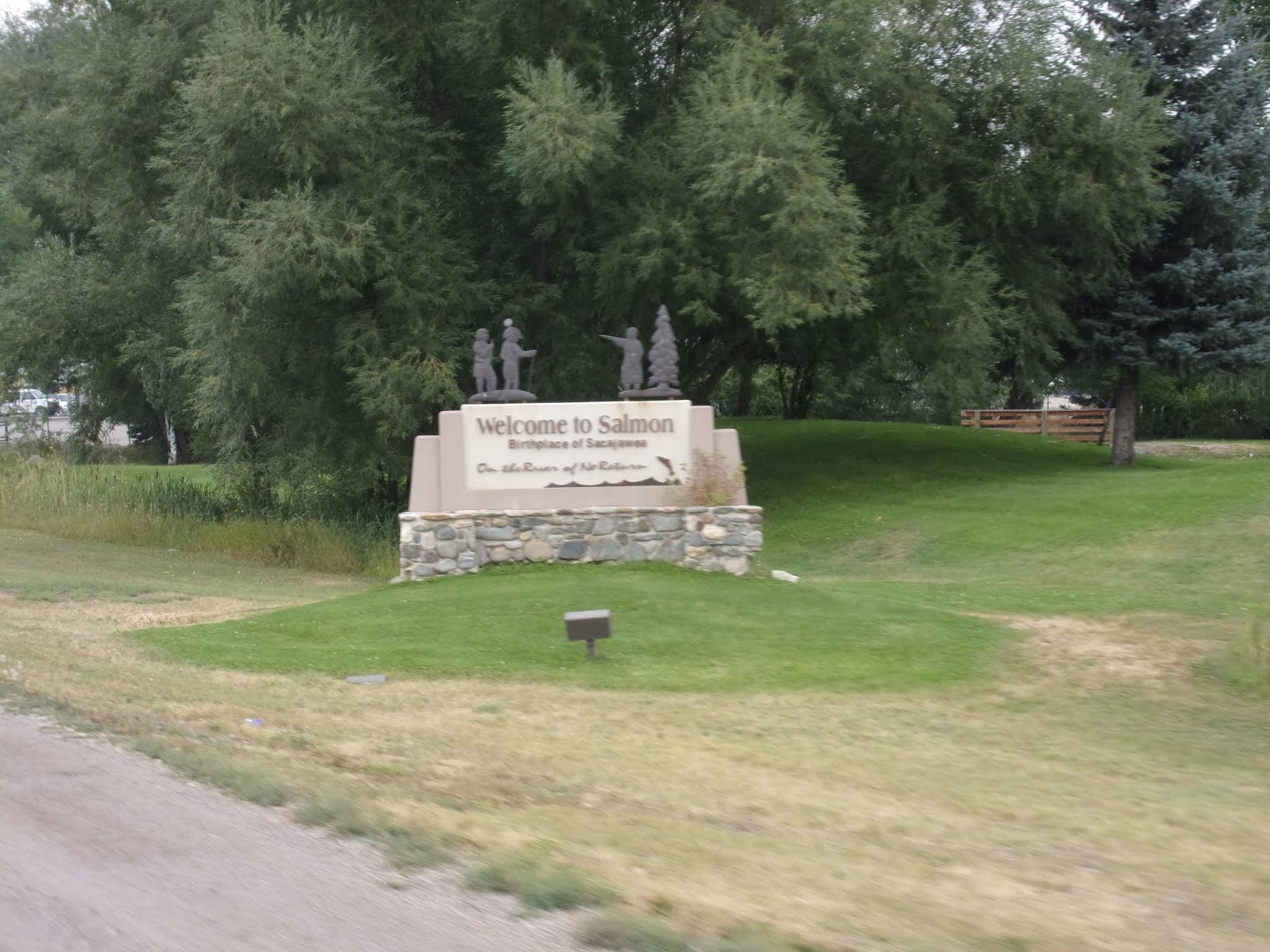
North of Challis, Highway 93 enters the Lemhi Valley and the mountains town of Salmon. Salmon conforms why Idaho is called the whitewater capital of the world. That’s because the Salmon River, or the “River of No Return” flows right through town.
Other epic adventurers from Salmon are Sacajawea, we will visit her center tomorrow. Also, American Ninja Warrior’s “Cowboy Ninja”, Lance Pekus. He may be the best athlete you’ve never heard of. The strapping, young Idaho cowboy, who runs cattle at his father-in-law’s ranch in Salmon and works seasonally for the US Forest Service, is making a name for himself on the TV sports competition “American Ninja Warrior.” His sexy signature look highlights his brawny physique: Shirtless, jeans and black cowboy hat.
The rain started just before we arrived at Wagonhammer campground, along the Salmon River. The Wagonhammer Springs are where Lewis & Clark camped on their expeditions.
Went to get gas, spotted deer, 2 eagles and ducks! No elk, bear or moose!
Another spectacular sunset and another good day on our Yankee RV Caravan!


No comments:
Post a Comment