 We spent 3 nights at Mt Desert Narrows, outside of Bar
Harbor.
We spent 3 nights at Mt Desert Narrows, outside of Bar
Harbor.
In those 3 days we toured Arcadia National Park, Bar Harbor
and the “back-side” or “quiet-side” of the island.
Before I tell you what we saw, I want to share some history.
Before the Europeans arrived from across the Atlantic, the Wabanaki Indians
inhabited the island. It is believed that the Wabanaki traveled to the island
from their home near the Penobscot River’s headwaters. During the summer, they
used the island to hunt, fish and gather berries near Somes Sound. Their
complete history can be viewed at the Abbe Museum in the park and there is an
expanded Abbe Museum in Bar Harbor. Many of Mt Desert Island’s towns bear the
names of the first settlers, like Abraham Somes. Artists arrived and word of
the island’s natural beauty spread. By the late 1800s, Bar Harbor had 30 hotels
and a reputation as a summer resort. This reputation was sealed soon after,
when America’s most socially prominent families … the Rockefellers, Morgans,
Fords, Astors, Vanderbilts and Pulitzers … began summering in Bar Harbor. They
built magnificent summer “cottages” of palatial dimensions, entertained
lavishly and forever altered the rustic character of the island.

Arcadia National Park is located on the rock-bound Maine
island of Mount Desert. It was first established as Sieue de Monts National
Monument, by President Woodrow Wilson, it was the first national park east of
the Mississippi. More importantly it was the first national park whose land,
over 50,000 acres, was donated entirely by private citizens.
 In Arcadia Nat’l Park we found soaring granite cliffs, sand
and cobblestone beaches and everything in between. Famed for its beauty and
rich wildlife, Arcadia, established in 1916, offers something of interest for
everyone. Experience the glorious views at the top of Cadillac Mountain, the
surf at Thunder Hole on Ocean Drive, and beautiful Sand Beach and majestic
Otter Cliffs.
In Arcadia Nat’l Park we found soaring granite cliffs, sand
and cobblestone beaches and everything in between. Famed for its beauty and
rich wildlife, Arcadia, established in 1916, offers something of interest for
everyone. Experience the glorious views at the top of Cadillac Mountain, the
surf at Thunder Hole on Ocean Drive, and beautiful Sand Beach and majestic
Otter Cliffs.
Driving the 27-mile long Park Loop Road is a scenic drive
offering a spectacular sampling of the island’s coast and interior features.
Most of the loop is one-way, with two-way traffic from Cadillac Mountain to the
horse stables, including Jordan’s Pond.
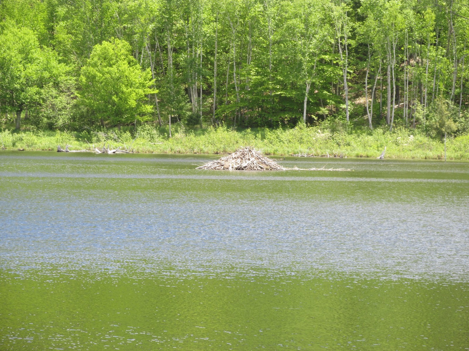
The Beaver Dam Pond is exactly what it sounds like … we saw
beaver mounds, but did not see any beavers!
 Thunder Hole is an ever-changing natural feature which does
not perform on a time table. Timing is everything here. As wind-driven tides
sweep into this narrow granite channel, air becomes trapped, escaping with a
thunderous bellow. The best time to hear it is at three-quarter rising tide
with a rough sea. At low tide on a calm day, Thunder Hole is stubbornly silent.
There are also wonderful views from Otter Cliff too.
Thunder Hole is an ever-changing natural feature which does
not perform on a time table. Timing is everything here. As wind-driven tides
sweep into this narrow granite channel, air becomes trapped, escaping with a
thunderous bellow. The best time to hear it is at three-quarter rising tide
with a rough sea. At low tide on a calm day, Thunder Hole is stubbornly silent.
There are also wonderful views from Otter Cliff too.
Until we arrived in Maine, I have never heard of the Gulf of Maine. I learned it is a large gulf of the Atlantic Ocean on the east coast of North America. It is marked by Cape Cod, Massachusetts in the southwest and Cape Sable Island, Nova Scotia in the northeast. This area definitely shows why it is called 'the Rocky Coast of Maine.'

Arcadia Nat’l Park is dotted with glacier-carved ponds and
lakes, Jordan Pond is perhaps the prettiest. Its waters are clear and cool. Its
shores are flanked by Penobscot Mountain and Pemetic Mountain. The view that
sets Jordan Pond apart lies to the north, and rising from the shore are a pair
of rounded mountains, aptly named, The Bubbles. While we were taking pictures,
Jack called them Double D.

A drive to Cadillac Mountain will never disappoint any
visitors, with its unbeatable 360 degree views … even on a cloudy day!

We saw a
cruise ship, the American Constellation, in Bar Harbor. Standing on the summit
at 1,530 foot is breathtaking and you are standing on the tallest mountain on
the Atlantic coast, north of Brazil.

Some visitors come to Cadillac Mountain at
dawn to see the sun rise in one of the first places in the US. We all scrambled
over the granite dome, cautiously of course!
On the back-side of the island, we saw …

Ike’s Point, was the first pull off we made. There was a
sign that talked about having your park pass ready. So, we drove down this
cut-off road and we quickly learned that we were heading down a boat launch!

We
backed back to the parking area and walked down. The water was calm and blue
and offered amazing views of Echo Lake, Echo Lake, Echo Lake! This was one of
the many times the ladies are snapping pictures and the three men are using their
binoculars!

Southwest Harbor is a town known for its boat building,
unique shops and working harbor.

At Clark’s Point, we drove down the hill and parked
on a bridge at low tide and walked on the docks.

We saw the Coast Guard Station
and Beal’s Lobster Pier.

In town, we parked near a small strip mall, that included a restaurant
called “Chow Maine”, we walked the town. We enjoyed Sawyer’s Market, for their eclectic
selection of gourmet and everyday items! Everyone enjoyed a taste of pizza from
Sawyer’s Specialties.

The public library is home to a statue titled “Sisters” …
it made me smile! There is a visitor information center in the old school and
we picked up some good information.

In Seawall the low tide exposes wide beaches of rocks.
During our trip, it was foggy. But, on a clear day these exposed rock beaches
create a dramatic foreground to Great Cranberry Island.

Bass Harbor is famous for its lighthouse. The Bass Harbor
Head Lighthouse rises from the rocky southernmost tip of Mt Desert Island. It
is one of the most photographed lighthouses on the East Coast. It was built in
1858, but is now fully automated and managed by the US Coast Guard.


Enjoyed lunch at Thurston’s Lobster Pound in Bernard, we saw the lobsters in the pre and post cooking status.

Bernard is one of the most genuine fishing communities on the island. That
statement is evident by the presence of all the lobster traps ready to to
deployed!

The blooms on the island were beautiful!

Tremont is less frequented by summer visitors, therefore
many miss the opportunity to see the island as it was before it became a resort
destination.

At Pretty Marsh Harbor, where we (well Jackie & I) walked
on the Ocean floor. Everyone else told us to keep the mud off our shoes!
Driving on Cape Road was exciting … especially riding with Jack & Jackie.
It was a paved road, then it became dirt … there was a grader working the road
and the drive became a bit more exciting … but it became paved again and all
was good!

We took the turn onto the dead end road, Beech Hill. The
information we had, said we could see the mountain form this road. We hiked on
a wet path for a while … Betty had us all laughing, when she said “I am not
enjoying this hike!” Betty and Charlie turned around, Walter, Jack, Jackie and
myself ventured a bit further … but ended up turning around when we ran into a
Ranger that said “there is nothing to see on this trail.” LOL

Somesville is a quaint village founded by the island’s first
settlers. It sits near the head of Somes Sound, The historic nature of the area
is immediately evident, even the houses have deed restrictions to help ensure
that the village retains its original character.

We took photographs on an icon curved bridge near the
gardens and museum. Limit of 5 people on the bridge, so no group photo … just
couples!

Bar Harbor is both a town and a village. The town occupies
about 1/3 of the island. Within the town are several villages including
Salisbury Cove, Hulls Cove, Town Hill and Bar Harbor. The village of Bar Harbor
is generally referred to as “downtown.” It is the commercial center of the
island with many shops, restaurants, lodging establishments, entertainment and
the town pier.

The day we toured downtown, there was another cruise ship in
port, the Maasdam F. It’s route is Quebec, Bar Harbor, Boston, Bar Harbor and
Quebec.

We watched a Seagull grab a crab out of the shallow water.
She continued to pick at it until she was able to enjoy her meal!
 We walked on the Sandbar, naturally, it is only available
during low tides. It is really more of a gravel and shell bar, than it is sand,
it takes you to Bar Island. It is open for about 3 hours, twice a day, during
low tide.
We walked on the Sandbar, naturally, it is only available
during low tides. It is really more of a gravel and shell bar, than it is sand,
it takes you to Bar Island. It is open for about 3 hours, twice a day, during
low tide. 
If you walk all the way across, onto the island, there is another
mile of trail that leads to the highest point on the island for a nice view
back at the village of Bar Harbor and Frenchman Bay. We did not walk that far!

We enjoyed walking in and out of all the shops. Just like
most tourist areas, the items in every shop were very similar to the shop next
to them. There were a couple exceptions, they were shops that sold items made
100% in Maine.
We had seen friends take friends to a place that had
huuuggge Blueberry Muffins. We found out that was Jordan’s Restaurant, so that
is where we lunched! We all had something different for lunch, but between the
three couples, we took home a dozen Blueberry muffins! Yum, yum, yum!
We never saw a sunrise, as this far north they come very
early! I am not even thinking about waking up at 3:50 am! One day Jackie really
wanted to go up to Cadillac Mountain to see the sunrise … I thought about it
for a while, but then I thought better and figured we better not!
No trip is complete ... without a few funny pictures ... enjoy ours!


No comments:
Post a Comment