When we first woke up on Thursday June 15, 2017, it
was over cast and could not get a good picture of the sun rise, but we did watch
the lobster fisherman check and set traps.
A side note ... cameras are interesting ... this picture was taken with a Canon Power Shot SX170IS. Great picture, quick focus, easy to use.
They bait the traps with fish, once they pull the
traps up, if there is any fish left, they throw it in the air and the sea gulls
get it.
Next side note ... this picture was taken with an Android phone, the LG G5. Awesome colors, my colors are always better on the phone, but can't focus and zoom as quickly!
We departed Ocean View RV Park, onto Highway 428 and
out of the town of Port au Choix. There was a cute homemade sign at a business.
I am not sure why he was apologizing for the government, but I can understand
about the bad roads!

On Highway 428, back toward the Viking Trail, you can
see the Keppel Island Lighthouse is on an island just outside of the town of
Port Saunders. The town of Port Saunders got its name when three British war
ships returned from Battle Harbour, Labrador. A ship under the command of
"Admiral Saunders" came here and Port Saunders bears his name to the
present day. Port Saunders had its real beginning when a ship named the
"Modest" under the command of Captain Arnold from Halifax, Nova
Scotia arrived with lumber to build a lobster canning factory for
"Shurhand & Forest". James Singer, from Nova Scotia, built the
first house and was followed by more settlers from nearby settlements who were
interested in the lobster fishery. The factory operated until 1960 when it was
shut down because it was considered no longer profitable. In addition to the
lobster fishery, people began to fish cod and herring. Everyone grew their own
garden vegetables. In the meantime, the French Settlers had built their rooms
on Keppel Island.

The French Settlers had their own fishing boats and
would salt and later dry their fish before sending it back to France. In
addition to the cod fishery, they used nets to drag the rivers for salmon which
they split and sent back to France. In 1958, Cyde House built the first fish
plant in the area which split and salted codfish. This led the way for further
economic development of the town. The following year saw the addition of a
general store, post office, and even a commercial wharf was built. In years
past, when boats were the dominant mode of travel, Port Saunders was a major
port of call. Evidence of this remains in some of the old buildings on the
wharves. Near the mouth of the harbor is Keppel Island where the lighthouse
guides the harbor entrance. The lighthouse was a kerosene burning lighthouse
when it was first built in 1901. The island itself was a Spanish burial ground,
and later French settlers built houses on the island. Today, tourists can visit
the island and view the lighthouse. Their harbor has been a haven for many
ships throughout history and that proud marine tradition still continues with the
modern fishing industry of today.
We headed north on Highway 430 once again. It is a quick
trip today, less than 80 miles! So, I will talk about some of the unique things
we have seen in Newfoundland.
On our drive through The Great Northern Peninsula we
noticed what looked like garden plots squeezed in along the Viking Trail. There
are some single plots or 2 or 3 together often fenced in with an assortment of
logs and boards or sometimes with netting. We started to see people working in
these roadside gardens cultivating the soil into neat rows and getting ready to
plant. Some of these plots were a great distance from any houses or populated
areas and we weren’t sure how these remote gardens came to be.
Most of the plots that we were driving past were
started in the late 1960′s when the highway was constructed. Up until then
gardening had been a challenge due to the lack of plentiful and fertile soil
along the coast. However, when the major road was built the dirt was piled up
alongside the road where it could be put to great use in growing the main
Newfoundland crops of potatoes, carrots, cabbages, beets, turnips and other
root vegetables. No garden would be complete without a row of cabbage. The only
no trespassing signs are plastic bags fluttering from the poles, old clothes
drenched in urine draped on the sides, and the makeshift fencing. The growing
season is short and the vegetables are moved to outdoor root cellars for
storage.
As we traveled on the Great Northern Peninsula, the
Northern tip of the island of Newfoundland, we traveled in the lowlands along
the coastline, with the Long Range Mountains providing a spectacular backdrop.
The coastline presents a kaleidoscope of bays and inlets, islands, jagged
headlands, with forested areas inland. There are over 69 distinct communities
in close proximity to one another. These communities share services such as
schools, health care and other public services. On the Long Range Mountains, we
saw more snow!
Highway 430, the Viking Trail, follows the coastline
up to St. Anthony at the most northern tip of the peninsula. The ferry link to
Southern Labrador operates from St Barbe, where we are headed today. With the
completion of the Trans Labrador Highway in 2009, the Great Northern Peninsula
is now connected to mainland Canada via the 60 mile crossing from St Barbe,
Newfoundland to Labrador.
We have seen the thousands and thousands of dollars worth of fishing equipment stacked in piles along the roadside on the highway. There are lobster traps by the thousands and crab traps by the hundreds. There are nets and lines. We had all seen them. People here leave their doors unlocked and their stores miles from their houses and never worry about their things. Life on the "rock" is often harsh and brutal, particularly in the winter, and that the person one might steal from, might be the very same person who the next day will be lifting you from the freezing sea. It’s the Code and no enforcement is needed. It is just understood.
Driving along the highway, there are special bridges
for snowmobiles and 4-wheelers. As well as, homemade ramps over the culverts on
the side of the road.
Another familiar sight along Newfoundland and
Labrador roads, especially in the Northern Peninsula, was an endless stacks of
roadside woodpiles. A fee is paid to the
government, to obtain a permit to cut wood on public land. Then the wood is hauled to a roadside area
for storage, where longer logs are arranged in a pyramid, teepee style, to
allow them to dry out.
Once seasoned, the wood is chopped to stove-length
and stacked in neat, standard size rows.
Winter lasts at least six months in Newfoundland, and fuel prices are
very high, so most families go through lots of firewood each year. Like the
roadside gardens, these woodpiles are not targets for theft. According to locals, you don't steal from
your neighbor in Newfoundland. The harsh
conditions and often brutal winters require a culture of interdependence for
survival.
The wood is a means of glowing red hot stoves, huge
kettles of steaming stews meant to be shared with family and friends all winter
long. There is no need to steal, because even the firewood will be shared with
all, if needed, and everyone knows it. What a wonderful way to live... and some
call these people poor… they are rich!
The dominate tree in this area is Black Spruce. It is
a slow-growing, small to medium-sized conifer that normally grows tall and is
skinny. The pinecones can last up to 30 years in clusters. It is lightweight but
stronger than white spruce. It is classified as medium in strength, but above
average in stiffness. Black spruce is widespread in Canada and is found growing
in every province and territory. It is a typical tree of the forest. It marks
the northern limit of tree growth and black spruce trees near this limit are
often found to be up to 90 years old with a bole diameter of 2 inches.
Plum Point was originally known as Old Ferolle, but
the community's name was changed to Plum Point in 1931 to distinguish it from
New Ferolle. The community's first European inhabitants were Basque fishermen.
They used Plum Point as a base for final preparations before their annual
return to Europe from their summer fishery. It was later used by the French
during the time that France had the French Shores in Newfoundland as a fishing
room. In 1884, there were 30 settlers but the area was later abandoned and the
next recorded settler was Henry Coombs in 1897. Residents of Plum Point relied
on the fishery - mainly cod, lobster and herring for their livelihood. In 1928,
the International Pulp and Paper Company began a pulpwood cutting operation in
the area.

The population of the town remained small until the 1960's when a
number of families from Current Island and St. Genevieve Bay resettled here.
These new residents combined with the completion of the highway along the Great
Northern Peninsula, Route 430, in 1969 saw Plum Point become a small service
center for the area. These services include; automotive, gas, food and accommodations. Plum Point include a K-12 school, Viking Trail
Academy, we passed by just as the kids were getting out for recess. We found
them running alongside the road with their hockey sticks in hand.
 |
| Photo Credit: Jack-n-Jackie Laubach |
There are also hiking trails and an abundance of
wildlife and birds to see. Jack and Jackie spotted this Eagle.
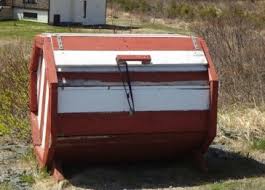
Beyond urban areas, virtually every house in
Newfoundland has a wooden receptacle near the roadside for the purpose of
storing garbage. They come in an endless
variety of designs, some to match the house, some just whimsical. Some sport the house number, and some even
support the mailbox. Whatever the
design, they keep seabirds, bears or whatever other wildlife your neighborhood
harbors out of your garbage.
St Barbe is an important transportation site for the
Great Northern Peninsula, the community is the site for the Strait of Belle
Isle Ferry. The MV Apollo crosses daily from St Barbe to Blanc Sablon, Quebec
and Labrador. St Barbe is also home to the region's ice arena and host a
variety of events such as broomball, skating, and hockey. In addition, St Barbe
is proud to host the annual Straits Festival each summer.
We arrived at St Barbe RV Park, our home for two
nights. It is a simple RV park, but has all we need! The all gravel lot has
back in sites to accommodate 26 rigs, with electric. There is a central dump
and a building. The building features cable TV, Wi-Fi, affordable laundromat,
showers, and kitchen facilities. The entire park is fenced in and there is a
path to the waterside to view incredible sunsets!

After we got set up, we took a trip further north.
Located between Anchor Point and Bear Cove is the small community of Deadman's
Cove. It is on a small flat plain, at the edge of the open waters of the Strait
of Belle Isle. Local residents believe that the community received its name
when this part of the coast was part of the French shore. One evening the
settlers heard fighting and arguments on a passing French vessel. The next
morning three French sailors were found dead by the seashore. For a short
period of time it was called Gengeville (a prevalent local surname), but it did
not last. The name later changed to "Deadman's Cove. James Chambers, a
seal fisherman, was the first known seasonal inhabitant of Deadman's Cove. The
settlers harvested the cod, herring, scallop, shrimp and seals, supplemented by
winter logging and the operation of the Genge farming business. It is here,
where we saw our first clear view of icebergs. They are a pretty awesome sight!
They even take on shapes, the first one we saw looked like a swan.
Our next stop was Flowers Cove. It was once called
French Island Harbor. Some people still call it "The Harbor". Local
lore claims that Flowers is a generic term used in Italian for any rock just
appearing on the surface of the water. During his mapping expeditions in 1764,
Captain James Cook labeled Flower's Cove "Flour Cove". The period of
greatest growth in population in the area occurred during its first period of
settlement. In 1951 the population stood at 281 and by 1966 it had reached 338.
The early economy of the area was based on seals, herring, cod and some
furring. Driving around, we found a mural that portrayed seven key features of
Flowers Cove, the lighthouse, the lighthouse keeper’s residence, Thrombolites,
Marjorie’s Bridge, White Rocks and a church. We had to find all seven!
The Flower's Cove Lighthouse is only viewed from a
distance. It sits on an island off the
town of Flower's Cove. The Lighthouse on Flowers Island was first put into
service on Nov. 7, 1899 on land then leased from Newfoundland by the Canadian
Government. Canada, which was a separate country from Newfoundland until 1949,
wanted to protect ships that traveled north of Flowers Cove through the Strait
of Belle Isle.
Flower's Cove is famous for thrombolites, very rare
fossils which can be seen on the coast in the southern part of the town,
remnants of bacteria and algae. Some of the most primitive life forms on the
plant, Thrombolites, can be found hiding in plain sight, among the rocks of
Flowers Cove. Thrombolites are the only known forms of life from over 3 billion
to 630 million years ago. They are extremely rare and can only be matched to
the other side of the world in Australia. Along the coastline, these bun
shaped, unicellular creatures have left a large reminder for us to witness
their existence in the fossil records. This amazing geological find can be
viewed from the town’s Thrombolites Walking Trail, a very easy 15 minute walk.
The most famous and largest church is the St.
Barnabas Anglican Church. It is also known as Skin Boot Church, as leather
shoes were sold for the church fund when the church was built in the 1920s.
It may seem hard to believe today, but years ago before
the construction of the Viking Trail highway, Marjorie’s Bridge was the only
way to get across Lawless Brook on your way up or down the coast of the Great
Northern Peninsula. That is, if you weren’t walking. Today, the bridge, while
was originally constructed over 100 years ago, connects a walking trail from
Burke’s Road to Lawless Point. It was lovingly restored and named after
Marjorie “Burke” Myers.

The White Rocks trail is dedicated to the memory of
the First World War Veteran Lt Albert S Rose. The white rocks are limestone
(calcium carbonate) and dolomite (calcium magnesium carbonate). There are
clefts eroded deep in the limestone and it is there that plants grow in their
shady rock gardens. The trail is raised off the marshy areas by a wooden plank
walkway. On a sunny clear day, the views are spectacular. They were very good
the day of our visit.
 |
| Photo Credit: Jack-n-Jackie Laubach |
One of the province’s largest concentrations of
moose occurs in this wilderness area. Jack, Jackie, Walter & Betty saw a
Moose.
We all enjoyed an early afternoon happy hour with
little known facts about more of the caravaneers. Some of us enjoyed an optional
dinner at Dockside Motel & Restaurant. Charlie suggested a cheeseburger, and
he made an excellent choice, because was that ever delicious!
It was a restful evening, in preparation for our trip
to Labrador tomorrow. Nights in Newfoundland, would not be complete without a
sunset! Okay, tonight and many nights in Newfoundland, the sun sets too late!


 The White Rocks trail is dedicated to the memory of
the First World War Veteran Lt Albert S Rose. The white rocks are limestone
(calcium carbonate) and dolomite (calcium magnesium carbonate). There are
clefts eroded deep in the limestone and it is there that plants grow in their
shady rock gardens. The trail is raised off the marshy areas by a wooden plank
walkway. On a sunny clear day, the views are spectacular. They were very good
the day of our visit.
The White Rocks trail is dedicated to the memory of
the First World War Veteran Lt Albert S Rose. The white rocks are limestone
(calcium carbonate) and dolomite (calcium magnesium carbonate). There are
clefts eroded deep in the limestone and it is there that plants grow in their
shady rock gardens. The trail is raised off the marshy areas by a wooden plank
walkway. On a sunny clear day, the views are spectacular. They were very good
the day of our visit.


No comments:
Post a Comment