
On Friday June 16, 2017 we carpooled to the St Barbe
Ferry dock, about 1/2 mile from the campground, for our long anticipated ferry ride to Labrador. This Ferry, reminds
me of the Cape May – Lewes Ferry, except you can put cars below deck as well as
above.


On this ferry route, you sail the Strait of Belle
Isle, nicknamed Iceberg Alley for the numerous icebergs that move along here. Initially,
icebergs were a bane for Newfoundland and Labrador trap fishermen. The massive
chunks of ice that have broken off of northern glaciers would drift through
waters taking whatever fishing gear that lay in its path with it. But with
changing times it’s something they have come to embrace, as the beauty of this
ice rose just can’t be denied. They are revered so much, that they have a
10-day Iceberg Festival in early June. We saw several, and they were as
breathtaking, big and blue, as we had heard!

We departed the Blanc Sablon Port, in Quebec, which
is the western terminus of the ferry and drove thru 500 yards of Quebec. Does that mean we can say we were in Quebec?


We crossed into Labrador and headed north to Route
510. Welcome to the "Big Land," Labrador is also known as "the Rock." The first 50 miles of Route 510, as far as Red Bay, are paved, and the
remaining stretch to Happy Valley-Goose Bay is gravel. They are starting to
paving from Happy-Valley, Goose Bay south toward Red Bay. But, it is a slow and
expensive process. They have 80 miles done and it is over 4 million dollars!

L'Anse-au-Clair is the first community that you'll
come to in Labrador. It was founded by the French in the early 1700s. It is a
scenic fishing out-port with local craft stores. There's also a restored early
20th-century church, which now serves as the Gateway to the Labrador Visitor
Center displaying the history and heritage of the area and information on what
to see and do. The nearby Jersey Room Hiking Trail leads to an interpretation
area on Jerseymen from the Channel Islands who fished here in the 17th century.

L’Anse Amour National Historic Site of Canada
overlooks the waters of the Strait of Belle Isle near the small modern
community of L’Anse Amour. It is the location of the Maritime Archaic Burial
Mound where archaeologists discovered the oldest known funeral monument in
North America. The Maritime Archaic people buried a 12-year-old boy here 7,500
years ago with an elaborate reverence that is unique for that era. Aboriginal
people lived here as early as 9,000 years ago when it was on the edge of the
retreating glaciers. A series of small campsites and burial grounds are all
that remain of these early relatives of Paleo-Indian caribou hunters of
northeastern North America. The descendants of these early inhabitants of
southern Labrador later fished and hunted whales in the Strait of Belle Isle.
The numerous species of fish and seabirds along the coast also supported later
bands of Inuit and even Newfoundland's Beothuk Indians who made their homes
here. Some of the artifacts found at the site have been reproduced and are on
display at the Labrador Straits Museum and Craft Shop just a few miles away
overlooking L'Anse Amour. The museum features displays on the contribution
women have made to the Straits area.
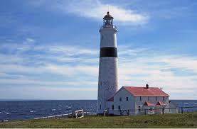
Lighthouses were built to provide a guidepost to
mariners at sea, bridging the gap between ships and shore. They worked in
isolated areas, amidst harsh weather conditions, to provide safe guidance. A visit
to the Point Amour Lighthouse Provincial Historic Site is a must! The Point
Armour Lighthouse was first designated a heritage lighthouse under Canada’s
Heritage Lighthouse Protection Act in December 2013. One of the iconic symbols
of the Labrador Straits, with countless tales passing from generation to
generation, particularly of the Wyatt family and their 84-year reign of light keeping.
The tour, built in 1857, stands at 109-foot lighthouse, the second tallest and
one of the two oldest still working in Canada. The light has been automated
since 1995.

The beacon was initially placed there to guide the ships.
Nonetheless, the region was still the home of many shipwrecks. The most famous
is the HMS Raleigh which went aground near Point Amour on August 8, 1922. The 605
foot, 700 crew British warship, which weighed some 12,000 ton, was steaming
from Port Saunders toward Forteau Bay where officers were to partake in some
salmon and trout fishing. With the kind of heavy fog that often cloaks the
coast obscuring its path, the Raleigh approached its destination, barely
missing a massive iceberg in its path. While avoiding the collision with the
icy giant, the vessel veered into shallow waters, the rocks of Forteau Bay
ripping a 360 foot gash through the belly of the ship, grounding it just 200
yards from shore. Eleven lives were lost and the remaining officers and crew, more
than 680 people spent the night scattered about the buildings of the Point
Armor Light station.

I love the road signs! But, I should say … the road
was rough before we got to this sign! The speed limit was 80 kph, which is 50
mph … you cannot got 50 mph on these roads!

We continued to see icebergs as we headed further
north. You cross the Forteau River, that runs into
the Atlantic Ocean. In the summer months, trout and salmon anglers will be
standing in the many pools, steadies and rattles. The cooler weather we have
been not enjoying, has its benefits … it has kept the black-flies at bay! At
this time of year, they are taking no prisoners, whenever the air is warm and
calm. Where it's cool and breezy, they're not much of a problem. Thank God for
the cooler weather!

The first European settlers on the Southern Labrador
Coast came from England, the island of Jersey in the English Channel near
France, and Newfoundland, and in the mid-19th century most arrivals were from
Dorset, Devon and Somerset. After that, settlers tended to be Newfoundlanders
moving north, such as those who eventually settled at L'Anse-au-Loup – Captstan
Island, West St. Modeste and further north in Lodge Bay in what were at first
only temporary summer fishing stations.
During the month of August, Forteau is the home of the
annual Labrador Straits Bakeapple Folk Festival. The event is named for the
golden-colored berries, also called cloudberries, which grow in abundance along
this coast. They are a great delicacy when prepared as jams, jellies or sauces.
The festival has lots of berry picking, but the fun also includes baking
contests, traditional music, dance, song and storytelling. A variety of
distinct craft items are sold during the festival. They range from caribou skin
mittens and rug work to tapestries, carvings and colorful embroidered clothing.

At the end of the paved section of Route 510 you'll
find Red Bay. Red Bay is a natural harbor residing in the bay that gives it its
name, both names in reference to the red granite cliffs of the region. Because
of the sheltered harbor it was used during World War II as a mooring site for
naval vessels. In the bay are Penney Island and Saddle Island, which were used
by the Basques for their whaling operations. Before we toured the Museum and
Interpretive Center, we had to deliver our gifts and eat lunch.

For the last 30 years, Yankee RV Tour Caravaneers,
have brought staples to a village leader in Red Bay. Marilyn and her husband
Bim, have helped the members of the most remote Inuit villages in Labrador. She
collects items that are donated and shares them with the villages she visits.
Rod, our caravan Wagonmaster, and owner of Yankee RV Tours, provides us a list
of items she needs.

Marilyn is a unique, strong, dedicated woman … she has had more foster
children than we can count, she helps anyone in need and works hard to pass her
Inuit heritage onto the next generation. She owns a restaurant that is open in
Red Bay, during the warm months, The Whaler Restaurant. This is where we had
lunch and left our gifts. We had every car and the beds of three pick-up trucks
full of boxes and bags. We had to make a fireman’s chain to get all of the
boxes into the restaurant.

Red Bay is a fishing village and former site of several
Basque whaling stations on the southern coast of Labrador. Between 1530 and the
early 17th century, Red Bay, known as Balea Baya (Whale Bay), was a major
Basque whaling area. The site is home to three Basque whaling galleons and four
small chalupas used in the capture of whales. The discovery of these vessels
makes Red Bay one of the most precious underwater archaeological sites in the
Americas. Red Bay has been designated a National Historic Site of Canada, and
since 2013 it is one of seventeen Canadian sites added to the UNESCO World
Heritage List.

Sailors from southern France and northern Spain sent 15
whaleships and 600 men a season to the remote outpost on the Strait of Belle
Isle to try to catch the right whale and bowhead whales that populated the
waters there. In 1565, a ship, believed to be the San Juan, sank in the waters
off Red Bay during a storm. Other, smaller vessels, such as chalupas, have also
been recovered from the waters. Another galleon was found 25–35 feet below water in 2004. It
was the fourth trans-oceanic ship to have been found in the area. A cemetery on
nearby Saddle Island holds the remains of 140 whalers. Many of the people
buried there are thought to have died from drowning and exposure. Historians believe
that a decline in whale stocks eventually led to the abandonment of the whaling
stations in Red Bay. Today, we visited the interpretive center to learn the history.
The Red Bay National Historic Site Interpretative Center introduces you to this
site, the world's first industrial-scale whale fishery. Archaeologists have
uncovered an astounding number of tools and personal effects that confirm
European habitation of this coast during the 16th and 17th centuries. Many of
these are now conserved in the Interpretation Center. A Basque chalupa recovered from the waters of the bay and on
display in the museum. It is over 400 year old, reconstructed, whaling chapula!
The museum showcases extensive exhibits featuring actual artifacts from years
of archaeology work including actual Basque clothing, eating and drinking
utensils.

There is a large rusty shipwreck visible from the the Interpretation Center. It is the remains of the ship the Bernier that grounded in
1966 in the Red Bay Harbor by Saddle Island.

There is still plenty of snow outside of Red Bay. We
took this picture along the roadside, this is left over from the highway
department’s snow blower. Standing in front of it, gives you an idea of how
large this bank still is!

But, the snow is still in many more areas, than just
along the banks of the road.

On our way back down Route 510, we stopped at the
wooden bridge over the Pinware River. It is amazing that midway, the treed
scenery ends briefly at the bridge over the stunning Pinware River gorge. The
Pinware River, stocked with a healthy supply of salmon traveling upstream to
spawn.


As the road cuts east, you get views of the large
ponds or lakes, carved by glaciers and where hills dip down to the coast.

At County Cat Pond there are a few “summer” homes sit
in a mostly uninhabited landscape. More ponds are visible as the road as the
route cuts through a glacial landscape scattered with boulders. The unusually
large number of boulders – glacial erratics, as they're called. A glacial
erratic is a piece of rock that differs from the size and type of rock native
to the area in which it rests. "Erratics" take their name from the
Latin word errare (to wander), and are carried by glacial ice, often over
distances of hundreds of miles. Erratics can range in size from pebbles to
large boulder. Erratics provide an important tool in characterizing the
directions of glacier flows. Erratic distributions and glacial till properties allow for
identification of the source rock from which they derive, which confirms the
flow direction, particularly when the erratic source outcrop is unique to a
limited locality. Erratic materials may be transported by multiple glacier
flows prior to their deposition, which can complicate the reconstruction of the
glacial flow.

Did I mention the rough roads? They had ample signage indicating the roads were rough, but it was a mute point ... because most of the entire stretch we drove was rough!

We got back to the docks on time and waited for the ferry to arrive. They really do fill the ferry to the maximum when they load them!

The two Charlies were tired out from driving and navigating the rough roads and from our days adventure to Labrador!

When we got back to St Barbe, Yankee had a hot turkey sandwich dinner ready at the restaurant across from the campground.

The evening would not be complete, without a sunset!
No comments:
Post a Comment